just checking declination for Suunto M3 global

Bushwalking gear and paraphernalia. Electronic gadget topics (inc. GPS, PLB, chargers) belong in the 'Techno Babble' sub-forum.
Forum rules
TIP: The online Bushwalk Inventory System can help bushwalkers with a variety of bushwalk planning tasks, including: Manage which items they take bushwalking so that they do not forget anything they might need, plan meals for their walks, and automatically compile food/fuel shopping lists (lists of consumables) required to make and cook the meals for each walk. It is particularly useful for planning for groups who share food or other items, but is also useful for individual walkers.

just checking declination for Suunto M3 global

Postby gordononline » Sat 23 Nov, 2013 4:44 pm

IMG_0848.JPG
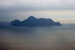
Pic of the declination adjustment
Hi

I normally navigate with a compass that I have to use Grid to Magnetic subtraction in ACT to account for declination.

I just bought a Suunto M3 global compass and I am setting the declination for the area covering the topo map for Perisher Valley [8525-2-S]. This map has NM 13.3 degrees east of GN.

While my understanding is that I should move the declination adjustment so that the red arrow in the inner dial is 13.3 (or close to) degrees east of the white N (north) mark on the outer black Bezel, I am cautious that I don't want to end up 26.6 degrees off target.

So for east declination the red inner arrow should be east of the outer bezel's white arrow? I tested this by applying this and another SILVA compass that didn't have declination adjustment to a map and when I subtracted the 13 degrees from the SILVA bearing it seemed to match what my SUUNTO shows.

Does this seem right?

I've attached a photo of the adjustment in case my message isn't clear.
gordononline
Nothofagus cunninghamii
 
Posts: 6
Joined: Sat 02 Mar, 2013 4:34 pm
Region: Australian Capital Territory
Gender: Male

Re: just checking declination for Suunto M3 global

Postby Mark F » Sun 24 Nov, 2013 9:44 am

It seems correct. When the red North end of the compass needle covers the red arrow then the N (0 deg on the bezel) indicates true north. You just match the compass set up with what you see on the map rose (the diagram showing the declination).
"Perfection is attained not when there is nothing more to add, but when there is nothing more to remove".
User avatar
Mark F
Lagarostrobos franklinii
 
Posts: 2301
Joined: Mon 19 Sep, 2011 8:14 pm
Region: Australian Capital Territory
Gender: Male

Re: just checking declination for Suunto M3 global

Postby GPSGuided » Sun 24 Nov, 2013 9:48 am

Yep, you've got it right. Mine has the same... Unless I am out by 24 or so degrees too (in Sydney). ;)

The only annoying thing is, they are always a degree or two out with my iPhone and GPS. As they say, man with 3 compasses won't know where to head.
Just move it!
User avatar
GPSGuided
Lagarostrobos franklinii
 
Posts: 6801
Joined: Mon 13 May, 2013 2:37 pm
Location: Sydney
Region: New South Wales

Re: just checking declination for Suunto M3 global

Postby neilmny » Sun 24 Nov, 2013 9:56 am

Mark F wrote:It seems correct. When the red North end of the compass needle covers the red arrow then the N (0 deg on the bezel) indicates true north. You just match the compass set up with what you see on the map rose (the diagram showing the declination).


Wouldn't that be Grid North Mark?
I think he is setting the declination for Magnetic North / Grid North
(I know there is very little difference)
User avatar
neilmny
Lagarostrobos franklinii
 
Posts: 2576
Joined: Fri 03 Aug, 2012 11:19 am
Region: Victoria
Gender: Male

Re: just checking declination for Suunto M3 global

Postby photohiker » Sun 24 Nov, 2013 10:14 am

neilmny wrote:
Mark F wrote:It seems correct. When the red North end of the compass needle covers the red arrow then the N (0 deg on the bezel) indicates true north. You just match the compass set up with what you see on the map rose (the diagram showing the declination).


Wouldn't that be Grid North Mark?
I think he is setting the declination for Magnetic North / Grid North
(I know there is very little difference)


Probably. Also, another issue with using the map rose is that the degrees declination varies over time, so accuracy is out the window if the map is not recent.
Michael
User avatar
photohiker
Lagarostrobos franklinii
 
Posts: 3097
Joined: Sun 17 May, 2009 12:31 pm
Location: Adelaide, dreaming up where to go next.

Re: just checking declination for Suunto M3 global

Postby GPSGuided » Sun 24 Nov, 2013 10:23 am

photohiker wrote:Probably. Also, another issue with using the map rose is that the degrees declination varies over time, so accuracy is out the window if the map is not recent.

I understand that the magnetic declination in our region is pretty stable with annual rate of change smaller than what we can adjust on such a unit. Not so with North America. Otherwise one can easily obtain the current value in the Internet age through various web sites.
http://magnetic-declination.com/
Just move it!
User avatar
GPSGuided
Lagarostrobos franklinii
 
Posts: 6801
Joined: Mon 13 May, 2013 2:37 pm
Location: Sydney
Region: New South Wales

Re: just checking declination for Suunto M3 global

Postby gordononline » Sun 24 Nov, 2013 4:12 pm

Thanks all, new compass, worth checking. Too embarrassing ending up in the wrong spot.

I also saw a you-tube video of a guy using this compass in NZ in an area with around 23 degrees east declination -
http://www.youtube.com/watch?v=0y6XREbL_Lg

.... at around 3.30 mins into the video you can clearly see that the declination is set east.

Peace

Doug
gordononline
Nothofagus cunninghamii
 
Posts: 6
Joined: Sat 02 Mar, 2013 4:34 pm
Region: Australian Capital Territory
Gender: Male

Re: just checking declination for Suunto M3 global

Postby Strider » Mon 25 Nov, 2013 7:47 am

GPSGuided wrote:
photohiker wrote:Probably. Also, another issue with using the map rose is that the degrees declination varies over time, so accuracy is out the window if the map is not recent.

I understand that the magnetic declination in our region is pretty stable with annual rate of change smaller than what we can adjust on such a unit. Not so with North America. Otherwise one can easily obtain the current value in the Internet age through various web sites.
http://magnetic-declination.com/

The rate of change is also provided on map.
User avatar
Strider
Lagarostrobos franklinii
 
Posts: 5875
Joined: Mon 07 Nov, 2011 6:55 pm
Location: Point Cook
Region: Victoria
Gender: Male

Re: just checking declination for Suunto M3 global

Postby GPSGuided » Mon 25 Nov, 2013 10:19 am

gordononline wrote:Thanks all, new compass, worth checking. Too embarrassing ending up in the wrong spot.

There's a simple descriptor on that site too that's worth a reminder.
http://magnetic-declination.com/what-is ... nation.php
Just move it!
User avatar
GPSGuided
Lagarostrobos franklinii
 
Posts: 6801
Joined: Mon 13 May, 2013 2:37 pm
Location: Sydney
Region: New South Wales

Re: just checking declination for Suunto M3 global

Postby photohiker » Mon 25 Nov, 2013 10:40 am

Strider wrote:
GPSGuided wrote:
photohiker wrote:Probably. Also, another issue with using the map rose is that the degrees declination varies over time, so accuracy is out the window if the map is not recent.

I understand that the magnetic declination in our region is pretty stable with annual rate of change smaller than what we can adjust on such a unit. Not so with North America. Otherwise one can easily obtain the current value in the Internet age through various web sites.
http://magnetic-declination.com/

The rate of change is also provided on map.


True that :)

Image

This is for WOJ, and also, on this map, the variation between grid and true north is significant.

Not all maps have a usable map rose but this one has a method built into the map, and information regarding variability over the sheet (this is from OSGB Inverness and Loch Ness 1:50k):

Image

Lastly, if you're covering a lot of ground, declination is not a set and forget operation. On my Scotland walk, I started with 4 degrees 19 minutes west at Dornie and finished with 2 degrees 52 minutes west at Montrose. In practice, most of my off track walking was in the first half so I set the declination to about 4 degrees and changed it to about 3 degrees at the halfway mark. I used the compass a lot and didn't get lost. :)
Michael
User avatar
photohiker
Lagarostrobos franklinii
 
Posts: 3097
Joined: Sun 17 May, 2009 12:31 pm
Location: Adelaide, dreaming up where to go next.


Return to Equipment

Who is online

Users browsing this forum: No registered users and 56 guests

cron