Has anyone here been into Pillans Lake? What can you tell me about it? It looks like a good spot, with a 4wd track going in (only when Lake Augusta is nearly empty) and 2 huts nearby (with rather dull names: 'Hut Number 4' and 'Kerrisons Hut Number 2').
Are the huts still there? Are they any good? Is there good camping anywhere near the lake? Sheltered areas? The maps indicate scattered pencil pine forest which sounds nice.
Is it easy to walk around to the far side of Lake Augusta and pick up the track (assuming the lake is not empty and I can't just follow the track straight through)? I've heard of a route that passes by Tin Hut lake... is that easy to find and follow?
I'm thinking of doing a winter weekend walk sometime, and this just looks interesting to me... lakes everywhere... I love what I've seen of the thousand lakes area so far.
Any Info on Pillans Lake?
Forum rules
Tasmania specific bushwalking discussion. Please avoid publishing details of access to sensitive areas with no tracks.
Tasmania specific bushwalking discussion. Please avoid publishing details of access to sensitive areas with no tracks.
18 posts
• Page 1 of 1
Any Info on Pillans Lake?
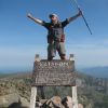
![]() by Son of a Beach » Fri 25 Jul, 2008 7:53 pm
by Son of a Beach » Fri 25 Jul, 2008 7:53 pm
- Son of a Beach
- Lagarostrobos franklinii

- Posts: 6917
- Joined: Thu 01 Mar, 2007 7:55 am
- ASSOCIATED ORGANISATIONS: Bit Map (NIXANZ)
- Region: Tasmania
- Gender: Male
Re: Any Info on Pillans Lake?
![]() by norts » Fri 25 Jul, 2008 9:20 pm
by norts » Fri 25 Jul, 2008 9:20 pm
I cant help you withPillans but dont plan on driving around Lake Augusta, I went up there in June to walk into the Walls. I didnt know there was a locked gate just after Bernachi. I had planned to drive to Lake Ada, Added about 18 ks to a 4 day walk.
Roger
Roger
-
norts - Lagarostrobos franklinii
- Posts: 2005
- Joined: Wed 01 Aug, 2007 10:45 am
- Location: Germantown Tas.
- Region: Tasmania
Re: Any Info on Pillans Lake?
![]() by BarryJ » Fri 25 Jul, 2008 9:31 pm
by BarryJ » Fri 25 Jul, 2008 9:31 pm
The gate usually isn't opened until sometime in October although it can be open during winter. Ring the ranger station at Liawenee to check the gate status. I am not sure of the status of the huts; they may well be private and locked!
There is, of course, another boom gate at the point where the Pillans/Julian 4WD track starts at Lake Augusta. This usually isn't opened until the level in Lake Augusta has been down for some time.
There is, of course, another boom gate at the point where the Pillans/Julian 4WD track starts at Lake Augusta. This usually isn't opened until the level in Lake Augusta has been down for some time.
- BarryJ
- Athrotaxis cupressoides

- Posts: 207
- Joined: Sun 11 Mar, 2007 6:56 pm
- Location: Glenorchy, Tasmania
- Region: Tasmania
- Gender: Male
Re: Any Info on Pillans Lake?
![]() by Robbo » Fri 25 Jul, 2008 11:23 pm
by Robbo » Fri 25 Jul, 2008 11:23 pm
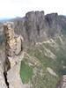
I walked from the Walls to Pillans via Butters, and then to Augusta, last November. Hut 4 is a locked hut - I have the phone numbers listed on the hut if you are interested. Hut 2 is an open hut. The further east you walk the drier the more straggly the vegetation becomes. There is very few Pencil Pines east of Butters from memory. The fishermen I have spoken to tell me that it is a good fishing lake. The walking is rather easy through the whole of the area. A good walk may be from Ada to Taleh Lagoons, then up Quail Gully to the Pillians and then back around to Ada.
I've attached a photo looking down over the northern end of Pillans.
Tony Robinson
I've attached a photo looking down over the northern end of Pillans.
Tony Robinson
- Attachments
-
- Pillans.jpg (42.03 KiB) Viewed 12778 times
"The place between your comfort zone and your dream is where your life takes place." Nick Vujicic.
-
Robbo - Athrotaxis cupressoides
- Posts: 288
- Joined: Sat 07 Jun, 2008 8:31 pm
- Location: Melbourne
- ASSOCIATED ORGANISATIONS: Gilson College
- Region: Victoria
- Gender: Male
Re: Any Info on Pillans Lake?
![]() by Son of a Beach » Sat 26 Jul, 2008 9:30 am
by Son of a Beach » Sat 26 Jul, 2008 9:30 am
norts wrote:I cant help you withPillans but dont plan on driving around Lake Augusta, I went up there in June to walk into the Walls. I didnt know there was a locked gate just after Bernachi. I had planned to drive to Lake Ada, Added about 18 ks to a 4 day walk.
Roger
I was planning to walk rather than drive from Lake Augusta (at about Bernachi), anyhow, so that's not a bit deal for me. So I guess I'd like to get some idea of how easy it would be to walk around the north east side of Augusta to meet up with the Pillans track at the North side of the lake. I'm guessing it would be mostly fairly easy, but there are two river crossings: Ouse and Thompsons. Does anyone know what these are like at Lake Augusta?
- Son of a Beach
- Lagarostrobos franklinii
- Posts: 6917
- Joined: Thu 01 Mar, 2007 7:55 am
- ASSOCIATED ORGANISATIONS: Bit Map (NIXANZ)
- Region: Tasmania
- Gender: Male
Re: Any Info on Pillans Lake?
![]() by heplittledoggie » Sat 26 Jul, 2008 1:27 pm
by heplittledoggie » Sat 26 Jul, 2008 1:27 pm
The 'usual' walking route (well the one that I use anyway) is via Tin Hut Lake, starting from the road at the eastern shore of Augusta. That way you could park at the gate and walk the road to the eastern shore. Up Christys Creek system is another way. I'd be surprised if you could get across Augusta at the moment - it's very shallow and fills quickly (maybe similar for Ouse and Thompsons rivers?), but from Bernacchi might be possible (I've never gone in that way).
Interesting read on this site:
http://www.sportsfishtasmania.com/phpBB ... d3718a1473
Interesting read on this site:
http://www.sportsfishtasmania.com/phpBB ... d3718a1473
- heplittledoggie
- Nothofagus gunnii

- Posts: 21
- Joined: Thu 24 Jul, 2008 11:29 pm
- Region: Tasmania
Re: Any Info on Pillans Lake?
![]() by flyfisher » Tue 12 Aug, 2008 9:58 pm
by flyfisher » Tue 12 Aug, 2008 9:58 pm
Nick, if you are going to walk to Pillans from Bernachi, there was an old 4wd track leading nw from near the Bernachi end of the dam to the right of the rocks. This goes through Thompson's rivulet and on to a ford in the Ouse river.There was a bridge hereabouts many moons ago to give access to Allisons hut (no1)
which is just under little Splitrock.
If lake Augusta is not at a high level the easier way is to cross the Lake on the 4wd track starting at 55s463276e 5365737n. There is a foot bridge over the James river at the ford in the middle of the lake bed.
From Allisins hut climb following track to n then nw till over the hill when you can see a fair way out in good weather.Approaching lake Julian ,Kerrisons hut can be seen to the left along a spur track.both this hut and Allisons are open to the public. From Kerrisons heading north anound the small lake then west will give access to Pillans shoreline.An old track to the shore may be found in this area,and I think the hut was meant to be built on the shore but vehicles became bogged so the hut was built at present location.
Another good access to the eastern side of Pillans is from a start at the sw end of Augusta 55s459094e 5364096n then up the track past huts alongside the lake and on nw to Stumps lake (named after "Stump "Jordan )then past Wadleys lake (for Reg Wadley) continuing on to meet Pillans where a crossing can be made at calf deep in summer.55s 451825e 5370303n.
Yet another approach is from the Lake Fanny track ,leaving the track at 55s450583e 5364192n just past Christy's lagoon and heading basicly north up Christys creek , past Lunka lake and small lagoons to the southern end of Pillans.
This whole area is nice walking ,if a little rocky but very exposed and best visited in nice weather
Hope this is of some help.
Flyfisher
which is just under little Splitrock.
If lake Augusta is not at a high level the easier way is to cross the Lake on the 4wd track starting at 55s463276e 5365737n. There is a foot bridge over the James river at the ford in the middle of the lake bed.
From Allisins hut climb following track to n then nw till over the hill when you can see a fair way out in good weather.Approaching lake Julian ,Kerrisons hut can be seen to the left along a spur track.both this hut and Allisons are open to the public. From Kerrisons heading north anound the small lake then west will give access to Pillans shoreline.An old track to the shore may be found in this area,and I think the hut was meant to be built on the shore but vehicles became bogged so the hut was built at present location.
Another good access to the eastern side of Pillans is from a start at the sw end of Augusta 55s459094e 5364096n then up the track past huts alongside the lake and on nw to Stumps lake (named after "Stump "Jordan )then past Wadleys lake (for Reg Wadley) continuing on to meet Pillans where a crossing can be made at calf deep in summer.55s 451825e 5370303n.
Yet another approach is from the Lake Fanny track ,leaving the track at 55s450583e 5364192n just past Christy's lagoon and heading basicly north up Christys creek , past Lunka lake and small lagoons to the southern end of Pillans.
This whole area is nice walking ,if a little rocky
Hope this is of some help.
Flyfisher
If you don't know what I'm talking about, then you need to drink more.
-
flyfisher - Athrotaxis selaginoides

- Posts: 1528
- Joined: Sat 14 Jul, 2007 8:39 pm
- Location: hobart
- ASSOCIATED ORGANISATIONS: landrover owners club of tasmania
- Region: Tasmania
Re: Any Info on Pillans Lake?
![]() by Son of a Beach » Wed 13 Aug, 2008 10:22 am
by Son of a Beach » Wed 13 Aug, 2008 10:22 am
Thanks guys... it's great to get insight into these areas from those who know them well.
- Son of a Beach
- Lagarostrobos franklinii
- Posts: 6917
- Joined: Thu 01 Mar, 2007 7:55 am
- ASSOCIATED ORGANISATIONS: Bit Map (NIXANZ)
- Region: Tasmania
- Gender: Male
Re: Any Info on Pillans Lake?
![]() by roseart » Fri 16 Sep, 2011 4:03 pm
by roseart » Fri 16 Sep, 2011 4:03 pm
I am wondering if anyone has walked from Lake Ironstone across to Pillians Lake 
If this is can be accomplished we are considering venturing onto the Walls of Jerusalem
via Lake Butters and onto Zion Gate.
If anyone has any experience of this area any information would be greater appreciated
This is a walk hopefully we will attempting late January, 2011
when the weather might be abit reasonable .
.
If this is can be accomplished we are considering venturing onto the Walls of Jerusalem
via Lake Butters and onto Zion Gate.
If anyone has any experience of this area any information would be greater appreciated
This is a walk hopefully we will attempting late January, 2011
when the weather might be abit reasonable
- roseart
- Nothofagus gunnii
- Posts: 32
- Joined: Mon 05 Nov, 2007 6:20 pm
Re: Any Info on Pillans Lake?
![]() by Vee » Sun 25 Oct, 2015 5:53 pm
by Vee » Sun 25 Oct, 2015 5:53 pm
Howdy All
We are thinking about walking from the Talleh Lagoons Track up towards Lake Pillans to spend 2 nights fishing and exploring. Where are the best spots to camp?
All advice most welcome. And..... where are the best fishing spots ???
Cheers and thanks
Vee
We are thinking about walking from the Talleh Lagoons Track up towards Lake Pillans to spend 2 nights fishing and exploring. Where are the best spots to camp?
All advice most welcome. And..... where are the best fishing spots ???
Cheers and thanks
Vee
- Vee
- Nothofagus gunnii
- Posts: 43
- Joined: Mon 09 Feb, 2009 6:37 pm
- Region: Tasmania
Re: Any Info on Pillans Lake?
![]() by flyfisher » Sun 25 Oct, 2015 8:31 pm
by flyfisher » Sun 25 Oct, 2015 8:31 pm
Hi, there is good fishing in the southern end of Pillans, but pay attention to the small lagoons to the south of the main lake.
Camping can be done anywhere you can find somewhere flat without too many rocks.
Lunka has some good spots as does Hunters.
Good luck and don't forget to post results.
FF
Camping can be done anywhere you can find somewhere flat without too many rocks.
Lunka has some good spots as does Hunters.
Good luck and don't forget to post results.
FF
If you don't know what I'm talking about, then you need to drink more.
-
flyfisher - Athrotaxis selaginoides
- Posts: 1528
- Joined: Sat 14 Jul, 2007 8:39 pm
- Location: hobart
- ASSOCIATED ORGANISATIONS: landrover owners club of tasmania
- Region: Tasmania
Re: Any Info on Pillans Lake?
![]() by Vee » Mon 26 Oct, 2015 8:40 am
by Vee » Mon 26 Oct, 2015 8:40 am
Hi flyfisher.
Thanks for the advice. Plan is to go this coming weekend. The ifs says gate is open to Ada. Will report in when we return; hopefully with some big tales of fishing
Cheers
Thanks for the advice. Plan is to go this coming weekend. The ifs says gate is open to Ada. Will report in when we return; hopefully with some big tales of fishing
Cheers
- Vee
- Nothofagus gunnii
- Posts: 43
- Joined: Mon 09 Feb, 2009 6:37 pm
- Region: Tasmania
Re: Any Info on Pillans Lake?
![]() by Son of a Beach » Mon 26 Oct, 2015 10:39 am
by Son of a Beach » Mon 26 Oct, 2015 10:39 am
(Yes, the gate is open. We drove through to Ada two weeks ago.)
- Son of a Beach
- Lagarostrobos franklinii
- Posts: 6917
- Joined: Thu 01 Mar, 2007 7:55 am
- ASSOCIATED ORGANISATIONS: Bit Map (NIXANZ)
- Region: Tasmania
- Gender: Male
Re: Any Info on Pillans Lake?
![]() by Vee » Mon 26 Oct, 2015 11:52 am
by Vee » Mon 26 Oct, 2015 11:52 am
Thanks son of a beach. Always good to hear from someone who has been there recently.
- Vee
- Nothofagus gunnii
- Posts: 43
- Joined: Mon 09 Feb, 2009 6:37 pm
- Region: Tasmania
Re: Any Info on Pillans Lake?
![]() by north-north-west » Mon 26 Oct, 2015 12:13 pm
by north-north-west » Mon 26 Oct, 2015 12:13 pm
From Talleh Lagoons through Quail Gully to Butters is very easy walking, and beautiful country. Can't comment on Butters to Pillans but it looks similar. The east side of Augusta up to Wild Dog Tier and through to Ironstone is also pretty easy going, and the country across to Pillans also looks open. Even if picking up the 4WD track north of Augusta is tricky, cross-country navigation and walking should be straightforward.
Go for it. It's a lovely area.
Go for it. It's a lovely area.
"Mit der Dummheit kämpfen Götter selbst vergebens."
-

north-north-west - Lagarostrobos franklinii
- Posts: 15404
- Joined: Thu 14 May, 2009 7:36 pm
- Location: The Asylum
- ASSOCIATED ORGANISATIONS: Social Misfits Anonymous
- Region: Tasmania
Re: Any Info on Pillans Lake?
![]() by flyfisher » Mon 26 Oct, 2015 12:22 pm
by flyfisher » Mon 26 Oct, 2015 12:22 pm
Yep, what nnw said is spot on.
FF
FF
If you don't know what I'm talking about, then you need to drink more.
-
flyfisher - Athrotaxis selaginoides
- Posts: 1528
- Joined: Sat 14 Jul, 2007 8:39 pm
- Location: hobart
- ASSOCIATED ORGANISATIONS: landrover owners club of tasmania
- Region: Tasmania
Re: Any Info on Pillans Lake?
![]() by Vee » Mon 26 Oct, 2015 8:35 pm
by Vee » Mon 26 Oct, 2015 8:35 pm
Thanks nnw. Sounds like we have lots to do
- Vee
- Nothofagus gunnii
- Posts: 43
- Joined: Mon 09 Feb, 2009 6:37 pm
- Region: Tasmania
Re: Any Info on Pillans Lake?
![]() by Vee » Tue 03 Nov, 2015 8:07 am
by Vee » Tue 03 Nov, 2015 8:07 am
Happy to report we had a good trip.
Day 1 we headed into Talleh Lagoons; caught one big fish which we had for tea and the remainder for breakfast with toast. It's a tricky business trying to cook a whole fish which is 2 foot long in a trangia size frypan - but we did it quite well. Stuffed him with bacon and cherry tomatoes and wrapped him in tinfoil with heaps of butter. Then kind of steamed the fish with a little water in the frypan' moving him along gently!
On day 2 we then fished our way north along the lagoons and headed up Quail Gully (where you suggested nnw) then we went over to Lunka. The wind was coming out of the north and it was quite unpleasant; so we decided against heading north and explored the area, did some fishing and camped at the lagoons at the southern end. There was a pair of black swans nesting in one of the lagoons. Are they very common up that way? The island out in Lunka is a sight to behold being covered in very old pencil pines. That night the wind blew and it rained.
Day 3, however was reasonably fine and we headed home via Christy's Creek seeing heaps of big fish; but they were a bit tricky to catch. The only one we hooked was way too big!!
Thanks for all the advice; it was a fun filled trip.
- Vee
- Nothofagus gunnii
- Posts: 43
- Joined: Mon 09 Feb, 2009 6:37 pm
- Region: Tasmania
18 posts
• Page 1 of 1
Who is online
Users browsing this forum: Google Adsense [Bot] and 38 guests