My family and I just blogged a 2-day (driving) wander through the West Coast. Nelson Falls was the biggest walk we did on our loop. While this is more of a nature trail than bushwalk, you will find my blog entry describes our passing through some classic tasmanian bushwalking territory. It sure served well to whet the appetite. In the space of only 7 hours driving over 2 days, we passed tracks such as:
St Valentines Pk*
Mt Pearse
Mt Farrell
Mt Murchisson*
The Tyndals
The Eldons
Mt Jukes
Nelson Falls*
Donaghys Hill*
Frenchmans Cap*
Jane River
Mt Gell
The King Williams
Mt Rufus
Pine River (a southern access route to the Walls)
Rats Castle*
Wild Dog Tier
Projection Bluff*
Quamby Bluff*
The walks marked with an Asterisk are ones I have completed in the past. There are still plenty on the 'to do list!' I hope this gives some useful suggestions to other forum folk.
West Coast Wandering
Forum rules
Tasmania specific bushwalking discussion. Please avoid publishing details of access to sensitive areas with no tracks.
Tasmania specific bushwalking discussion. Please avoid publishing details of access to sensitive areas with no tracks.
17 posts
• Page 1 of 1
West Coast Wandering
![]() by tastrekker » Tue 08 Jan, 2008 7:31 pm
by tastrekker » Tue 08 Jan, 2008 7:31 pm
-

tastrekker - Athrotaxis cupressoides

- Posts: 499
- Joined: Thu 20 Sep, 2007 9:04 pm
- Location: Lenah Valley
- Region: Tasmania
- Gender: Male
Re: West Coast Wandering
![]() by walkinTas » Wed 09 Jan, 2008 8:06 pm
by walkinTas » Wed 09 Jan, 2008 8:06 pm
So lets see, I'm guessing you did a round trip in through Ridgley, around the West Coast to Queenstown, then along the Murchison Hwy to Bronte, and up over the lakes highway to Deloraine, and home, or something similar?
Where does the track to the Eldons start, and how hard is the walk into Lake Ewart.
Where does the track to the Eldons start, and how hard is the walk into Lake Ewart.
Last edited by walkinTas on Wed 09 Jan, 2008 11:47 pm, edited 2 times in total.
- walkinTas
- Lagarostrobos franklinii

- Posts: 2918
- Joined: Thu 07 Jun, 2007 1:51 pm
- Region: Tasmania
Re: West Coast Wandering
![]() by corvus » Wed 09 Jan, 2008 9:22 pm
by corvus » Wed 09 Jan, 2008 9:22 pm
G'day All ,
I am a regular visitor to Queeni now and as I drive from Devonport I would like some advice as to easy one dayer in the area to break the drive.
corvus
I am a regular visitor to Queeni now and as I drive from Devonport I would like some advice as to easy one dayer in the area to break the drive.
corvus
collige virgo rosas
-

corvus - Vercundus gearus-freakius

- Posts: 5488
- Joined: Mon 23 Apr, 2007 7:24 pm
- Location: Devonport
- Region: Tasmania
- Gender: Male
Re: West Coast Wandering
![]() by TassieMargie » Thu 10 Jan, 2008 10:22 am
by TassieMargie » Thu 10 Jan, 2008 10:22 am
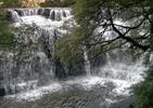
I can recommend the Montezuma Falls walk as I have done it. It says it takes about 3 hours return but I reckon it will take you as long as you want to take. Take a bit of lunch with you and enjoy the scenery and you could make it last all day if you wanted to.

- TassieMargie
- Atherosperma moschatum

- Posts: 81
- Joined: Sat 05 Jan, 2008 10:09 am
- Location: Rosebery Tasmania
- Region: Tasmania
Re: West Coast Wandering
![]() by Son of a Beach » Thu 10 Jan, 2008 10:57 am
by Son of a Beach » Thu 10 Jan, 2008 10:57 am
TasTrekker - I didn't see the Raglan Range on your list there!  The track (old Franklin Dam exploration bulldozer track) starts from almost across the other side of the Lyell Highway to the Nelson Fall walk, I believe (I took a shortcut, so didn't do the highway end of it).
TassieMargie - nice shot! I've not managed to get to the Montezuma Falls yet. I'm going to have to rectify that.
TassieMargie - nice shot! I've not managed to get to the Montezuma Falls yet. I'm going to have to rectify that.
- Son of a Beach
- Lagarostrobos franklinii
- Posts: 6918
- Joined: Thu 01 Mar, 2007 7:55 am
- ASSOCIATED ORGANISATIONS: Bit Map (NIXANZ)
- Region: Tasmania
- Gender: Male
Re: West Coast Wandering
![]() by TassieMargie » Thu 10 Jan, 2008 11:14 am
by TassieMargie » Thu 10 Jan, 2008 11:14 am
Thanks Nik. It is a really cool walk. It is easy and you can take your time and just look around.We went down there after a bit of rain so there was a fair bit of water going over it at the time.
tastrekker, I haven't heard of some of the places on your list. Nelson Falls is beautiful and have driven past most of the others. Thanks for the info, will have to check these places out one day
tastrekker, I haven't heard of some of the places on your list. Nelson Falls is beautiful and have driven past most of the others. Thanks for the info, will have to check these places out one day
- TassieMargie
- Atherosperma moschatum
- Posts: 81
- Joined: Sat 05 Jan, 2008 10:09 am
- Location: Rosebery Tasmania
- Region: Tasmania
Re: West Coast Wandering
![]() by Joe » Thu 10 Jan, 2008 1:18 pm
by Joe » Thu 10 Jan, 2008 1:18 pm
montezuma are spectacular. we did it on mountain bike..the track really lends itsself to bikes...nice and wide and plenty muddy in places. was filthy by time we got back to car.
-

Joe - in vino veritas
- Posts: 669
- Joined: Mon 26 Mar, 2007 10:35 pm
- Location: Devonport Tas
- ASSOCIATED ORGANISATIONS: Stoney Creek Outdoor Equipment.
- Region: Tasmania
Re: West Coast Wandering
![]() by tastrekker » Thu 10 Jan, 2008 9:48 pm
by tastrekker » Thu 10 Jan, 2008 9:48 pm
corvus wrote:G'day All ,
I am a regular visitor to Queeni now and as I drive from Devonport I would like some advice as to easy one dayer in the area to break the drive.
corvus
I have done Mt Murchison which is easy in that there is a very well defined, easy to follow track right from the Anthony Road. However, despite the road being fairly high on the mountain side, it's still a long steep haul to the summit.
Also on the Anthony Road, it's possible to get into the Tyndal Range. This is mostly trackless east of the roadexcept one 4WD trail that goes all the way to Lake Spicer. I think it is quite rough so I don't think many 4WDs go in there any more. Approx 10km along the track there's a ridge on the north shoulder of Walford Peak. This spot would offer awesome views of the rarely visited Eldons in the far SW corner of the Cradle Reserve. Quite a long day walk at 10km each way but possibly achievable if the 4WD track makes for easy walking. Maybe it's MTB-able? You would need the 1:25000 map with you. (Get a free low-res image from TheList)
On the western section of the Cradle Link Road, Mt Cripps has a short walking track up it according to the map. You get to it from a logging road off the south side of the Link Road west of the Black Bluff Range. On the Range itself, it's a very pleasant day walk to traverse the range south to Mt Beecroft, then descend into the fourways campsite where you can view Fosseys "incredibly beautiful waterfall" on the Vale River. The valley is very open and scrub free so it's easy to follow the river upstream back to the Link Rd for a change of scenery.
I completely agree with the comments re Montezuma. Very worthwhile. There are several other waterfalls along the southern section of the railway that are worth a visit if time permits.
Outside Zeehan, there are walks up Mts Zeehan and Agnew along with a number of walking possibilities to historic mining areas such as Cumberland Lake.
Back up toward the north west coast, I believe Mt Pearce has a track up it just south of Waratah amidst a sea of tree farming. Within Waratah itself, there's the walk down to the old powerstation below the waterfall and just out of Waratah Magnet is a great place for walking and/or MTB riding. Also near Magnet is the recently taped walk to Philosiphers Falls on the upper Arthur River. Valentines Peak while close to the Ridgley Hwy is actually climbed from Kara Road (which is not the road to Lake Kara) which in turn comes off the road between Hampshire and Upper Natone. Not a big detour from a Devonport-Queenie trip via Natone and Hampshire.
Even closer to the NW coast, Burnie is the undisputed waterfall capital of Tas with over a dozen falls within 30 mins drive of the city centre. Sadly many of these are on private property and difficult to visit. I can PM some tips though. I expect Mr taswaterfalls.com would also be full-bottle on this info.
My wife is calling out other suggestions in the Cradle area such as Quail Falls (huge single drop - short walk to a stunning spot) and Weaning Paddock Falls (close to the road but on private property).
-
tastrekker - Athrotaxis cupressoides
- Posts: 499
- Joined: Thu 20 Sep, 2007 9:04 pm
- Location: Lenah Valley
- Region: Tasmania
- Gender: Male
Re: West Coast Wandering
![]() by tastrekker » Thu 10 Jan, 2008 9:53 pm
by tastrekker » Thu 10 Jan, 2008 9:53 pm
walkinTas wrote:So lets see, I'm guessing you did a round trip in through Ridgley, around the West Coast to Queenstown, then along the Murchison Hwy to Bronte, and up over the lakes highway to Deloraine, and home, or something similar?
That's basically it.
walkingTas wrote:Where does the track to the Eldons start, and how hard is the walk into Lake Ewart.
The Eldons are an amazing destination and warrant their own topic. I'll start one off soon when I have some more time.
-
tastrekker - Athrotaxis cupressoides
- Posts: 499
- Joined: Thu 20 Sep, 2007 9:04 pm
- Location: Lenah Valley
- Region: Tasmania
- Gender: Male
Re: West Coast Wandering
![]() by TassieMargie » Fri 11 Jan, 2008 10:59 am
by TassieMargie » Fri 11 Jan, 2008 10:59 am
Thanks for the info tastrekker. Could you elaborate a bit more on the Mt Murchison track? Please?
- TassieMargie
- Atherosperma moschatum
- Posts: 81
- Joined: Sat 05 Jan, 2008 10:09 am
- Location: Rosebery Tasmania
- Region: Tasmania
Re: West Coast Wandering
![]() by pazzar » Sat 15 Oct, 2011 4:38 pm
by pazzar » Sat 15 Oct, 2011 4:38 pm
Just out of interest, is there a gate across the access road to Lake Spicer? I was thinking of bagging Walford Peak when I'm up there next and wondered about access.
Cheers,
Jared
Cheers,
Jared
"It's not what you look at that matters, it's what you see."
-
pazzar - Lagarostrobos franklinii
- Posts: 2657
- Joined: Thu 09 Jul, 2009 5:22 pm
- Location: Hobart
- Region: Tasmania
- Gender: Male
Re: West Coast Wandering
![]() by Taurë-rana » Sun 16 Oct, 2011 7:47 am
by Taurë-rana » Sun 16 Oct, 2011 7:47 am
Last time I went in there was a gate, but that was a number of years ago now. I think Parks Queenstown had the key. It was very definitely a 4WD track then.
Peak bagging points: 170ish
Recent walks - Picton, Wylds Crag, Rogoona
Recent walks - Picton, Wylds Crag, Rogoona
-
Taurë-rana - Phyllocladus aspleniifolius

- Posts: 960
- Joined: Mon 14 Jan, 2008 8:28 pm
- Location: Devonport
- Region: Tasmania
Re: West Coast Wandering
![]() by MJD » Sun 16 Oct, 2011 2:11 pm
by MJD » Sun 16 Oct, 2011 2:11 pm
It has a gate. A friend from work and a few others were in there a few months ago on their quad bikes.
Carpe diem
-

MJD - Athrotaxis selaginoides

- Posts: 1017
- Joined: Mon 26 May, 2008 11:24 pm
- Region: Tasmania
Re: West Coast Wandering
![]() by pazzar » Sun 16 Oct, 2011 4:52 pm
by pazzar » Sun 16 Oct, 2011 4:52 pm
So the trusty Corolla probably wouldn't make it down anyway? I guess its not that far to walk down to Walford.
"It's not what you look at that matters, it's what you see."
-
pazzar - Lagarostrobos franklinii
- Posts: 2657
- Joined: Thu 09 Jul, 2009 5:22 pm
- Location: Hobart
- Region: Tasmania
- Gender: Male
Re: West Coast Wandering
![]() by flyfisher » Sun 16 Oct, 2011 8:53 pm
by flyfisher » Sun 16 Oct, 2011 8:53 pm
It's about 9k's each way, and no. the trusty corolla would struggle, for sure.
ff
ff
If you don't know what I'm talking about, then you need to drink more.
-
flyfisher - Athrotaxis selaginoides
- Posts: 1528
- Joined: Sat 14 Jul, 2007 8:39 pm
- Location: hobart
- ASSOCIATED ORGANISATIONS: landrover owners club of tasmania
- Region: Tasmania
Re: West Coast Wandering
![]() by Twinhuon » Thu 17 May, 2012 11:26 am
by Twinhuon » Thu 17 May, 2012 11:26 am
Hi
You mentioned Quails falls near Cradle
I have not been to these before. Can you give me the details to get there.
Twinhuons
You mentioned Quails falls near Cradle
I have not been to these before. Can you give me the details to get there.
Twinhuons
- Twinhuon
- Nothofagus cunninghamii

- Posts: 1
- Joined: Thu 17 May, 2012 11:19 am
- Region: Tasmania
Re: West Coast Wandering
![]() by GerryDuke » Thu 17 May, 2012 4:25 pm
by GerryDuke » Thu 17 May, 2012 4:25 pm
I have Quaile's Falls covered on my site Twinhuon. A very pretty walk. I would like to get back there soon. There was a 'private property' signs nailed to the tree last time I went past though.
http://www.touringtasmania.info/quaile%27s_falls.htm
GD
http://www.touringtasmania.info/quaile%27s_falls.htm
GD
-
GerryDuke - Athrotaxis cupressoides
- Posts: 419
- Joined: Sun 18 May, 2008 12:04 am
- Location: KINGSTON BEACH, TASMANIA
- Region: Tasmania
- Gender: Male
17 posts
• Page 1 of 1
Who is online
Users browsing this forum: No registered users and 17 guests