Greystone Bluff
Forum rules
Tasmania specific bushwalking discussion. Please avoid publishing details of access to sensitive areas with no tracks.
Tasmania specific bushwalking discussion. Please avoid publishing details of access to sensitive areas with no tracks.
13 posts
• Page 1 of 1
Greystone Bluff
![]() by Dolerite Walker » Tue 26 Aug, 2014 2:53 pm
by Dolerite Walker » Tue 26 Aug, 2014 2:53 pm
Does anyone know whether it was affected by the bushfire of ~2 years ago that hit the Western Arthurs?
- Dolerite Walker
- Atherosperma moschatum

- Posts: 66
- Joined: Tue 03 Sep, 2013 10:52 am
- Region: Tasmania
- Gender: Male
Re: Greystone Bluff
![]() by icefest » Tue 26 Aug, 2014 4:39 pm
by icefest » Tue 26 Aug, 2014 4:39 pm
Men wanted for hazardous journey. Low wages, bitter cold, long hours of complete darkness. Safe return doubtful.
-

icefest - Lagarostrobos franklinii

- Posts: 4517
- Joined: Fri 27 May, 2011 11:19 pm
- Location: www.canyoninginvictoria.org
- Region: Victoria
Re: Greystone Bluff
![]() by icefest » Tue 26 Aug, 2014 4:49 pm
by icefest » Tue 26 Aug, 2014 4:49 pm
Do you want me to try to get a decent recent hi-res pic of the area?
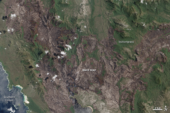
And this is a satellite image from yesterday, same as the second one, that depicts the amount of regrowth:

And this is a satellite image from yesterday, same as the second one, that depicts the amount of regrowth:
Men wanted for hazardous journey. Low wages, bitter cold, long hours of complete darkness. Safe return doubtful.
-
icefest - Lagarostrobos franklinii
- Posts: 4517
- Joined: Fri 27 May, 2011 11:19 pm
- Location: www.canyoninginvictoria.org
- Region: Victoria
Re: Greystone Bluff
![]() by icefest » Tue 26 Aug, 2014 5:12 pm
by icefest » Tue 26 Aug, 2014 5:12 pm
Here is a closeup from the 7th of February this year:

Men wanted for hazardous journey. Low wages, bitter cold, long hours of complete darkness. Safe return doubtful.
-
icefest - Lagarostrobos franklinii
- Posts: 4517
- Joined: Fri 27 May, 2011 11:19 pm
- Location: www.canyoninginvictoria.org
- Region: Victoria
Re: Greystone Bluff
![]() by Doonish » Wed 27 Aug, 2014 9:34 pm
by Doonish » Wed 27 Aug, 2014 9:34 pm
We took advantage of the fires to climb Robinson pretty easily earlier in the year.
Spent a lot of time looking across to Greystone wondering - and the visible aspects looked as scrubby and unpleasant as ever.
Spent a lot of time looking across to Greystone wondering - and the visible aspects looked as scrubby and unpleasant as ever.
- Doonish
- Atherosperma moschatum
- Posts: 54
- Joined: Sat 15 Sep, 2012 12:19 pm
- ASSOCIATED ORGANISATIONS: Fullers Bookshop
- Region: Tasmania
- Gender: Male
Re: Greystone Bluff
![]() by pazzar » Wed 27 Aug, 2014 9:46 pm
by pazzar » Wed 27 Aug, 2014 9:46 pm
I don't think it burnt that close on that side. If it had, every man and his dog would have been there at some point this year. Unfortunately the traditional approach over the Monolith's is still the way to go.
"It's not what you look at that matters, it's what you see."
-
pazzar - Lagarostrobos franklinii
- Posts: 2657
- Joined: Thu 09 Jul, 2009 5:22 pm
- Location: Hobart
- Region: Tasmania
- Gender: Male
Re: Greystone Bluff
![]() by icefest » Wed 27 Aug, 2014 10:54 pm
by icefest » Wed 27 Aug, 2014 10:54 pm
It looks like you have no problems climbing it from the west, via the burn scar leading up to Green Head, but that would entail a crossing of the crossing gorge, which doesn't look like fun.
Men wanted for hazardous journey. Low wages, bitter cold, long hours of complete darkness. Safe return doubtful.
-
icefest - Lagarostrobos franklinii
- Posts: 4517
- Joined: Fri 27 May, 2011 11:19 pm
- Location: www.canyoninginvictoria.org
- Region: Victoria
Re: Greystone Bluff
![]() by ILUVSWTAS » Thu 28 Aug, 2014 9:16 am
by ILUVSWTAS » Thu 28 Aug, 2014 9:16 am
pazzar wrote: Unfortunately the traditional approach over the Monolith's is still the way to go.
I think the true traditional approach is either over Green Head or Giblin.
Nothing to see here.
-

ILUVSWTAS - Lagarostrobos franklinii
- Posts: 11027
- Joined: Sun 28 Dec, 2008 9:53 am
- Region: Tasmania
- Gender: Male
Re: Greystone Bluff
![]() by north-north-west » Thu 28 Aug, 2014 1:08 pm
by north-north-west » Thu 28 Aug, 2014 1:08 pm
ILUVSWTAS wrote:pazzar wrote: Unfortunately the traditional approach over the Monolith's is still the way to go.
I think the true traditional approach is either over Green Head or Giblin.
Bugger tradition - how much would it cost to hire a chopper for a small group?
"Mit der Dummheit kämpfen Götter selbst vergebens."
-

north-north-west - Lagarostrobos franklinii
- Posts: 15493
- Joined: Thu 14 May, 2009 7:36 pm
- Location: The Asylum
- ASSOCIATED ORGANISATIONS: Social Misfits Anonymous
- Region: Tasmania
Re: Greystone Bluff
![]() by doogs » Thu 28 Aug, 2014 2:48 pm
by doogs » Thu 28 Aug, 2014 2:48 pm
pazzar wrote:I don't think it burnt that close on that side. If it had, every man and his dog would have been there at some point this year.
Dogs aren't allowed in National Parks in Tasmania
icefest wrote:It looks like you have no problems climbing it from the west, via the burn scar leading up to Green Head, but that would entail a crossing of the crossing gorge, which doesn't look like fun.
I been eyeing off the approach from the burn scar on Green Head for a while, reckon it's the go...but there'd still be a fairly long scrub bash to get to the top of Castle Greyskull. There's a bit of detail on the Crossing river on the paddling web pages with some photos, doesn't sound too bad to cross above the gorge.
Do you want to build a snowman?
-

doogs - Lagarostrobos franklinii
- Posts: 3649
- Joined: Mon 11 Oct, 2010 4:32 pm
- Region: Tasmania
- Gender: Male
Re: Greystone Bluff
![]() by icefest » Thu 28 Aug, 2014 3:34 pm
by icefest » Thu 28 Aug, 2014 3:34 pm
doogs wrote:I been eyeing off the approach from the burn scar on Green Head for a while, reckon it's the go...but there'd still be a fairly long scrub bash to get to the top of Castle Greyskull. There's a bit of detail on the Crossing river on the paddling web pages with some photos, doesn't sound too bad to cross above the gorge.
It wouldn't be easy, but there is a clear burned path upwards:
I'm up for it this summer!

Men wanted for hazardous journey. Low wages, bitter cold, long hours of complete darkness. Safe return doubtful.
-
icefest - Lagarostrobos franklinii
- Posts: 4517
- Joined: Fri 27 May, 2011 11:19 pm
- Location: www.canyoninginvictoria.org
- Region: Victoria
Re: Greystone Bluff
![]() by jmac » Thu 28 Aug, 2014 7:37 pm
by jmac » Thu 28 Aug, 2014 7:37 pm
Greystone was relatively easy from the west, even before the fire. It's just the getting to the west that is difficult. Matt and I found the west ridge virtually clear all the way to the top when we came through from the west coast a few years ago. The eastern flanks of Greystone and Green Head certainly deserve their reputation for steep thick scrub though. Tough country.
- jmac
- Athrotaxis cupressoides

- Posts: 175
- Joined: Wed 11 Nov, 2009 11:03 am
- Region: Tasmania
- Gender: Male
Re: Greystone Bluff
![]() by icefest » Thu 28 Aug, 2014 7:41 pm
by icefest » Thu 28 Aug, 2014 7:41 pm
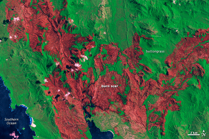
A bit more fun with the image, shows a better map of the burnt areas:
It looks like there is a clear burnt path north from crossing river.

It looks like there is a clear burnt path north from crossing river.
Men wanted for hazardous journey. Low wages, bitter cold, long hours of complete darkness. Safe return doubtful.
-
icefest - Lagarostrobos franklinii
- Posts: 4517
- Joined: Fri 27 May, 2011 11:19 pm
- Location: www.canyoninginvictoria.org
- Region: Victoria
13 posts
• Page 1 of 1
Who is online
Users browsing this forum: andrewp and 49 guests