Tasmania specific bushwalking discussion.
Forum rules
Tasmania specific bushwalking discussion. Please avoid publishing details of access to sensitive areas with no tracks.
Fri 05 Feb, 2010 11:49 am
frenchy_84 wrote:Can someone please post a photo of the difficult section of the notch? i have only done Mt Anne as a day trip so i havent seen the difficult section that may make some turn back?
Hi Frenchy,
There are several ways to tackle the notch.
Its been a few years since I've been there, but from memory getting into the notch from Shelf Camp's side isn't too difficult.
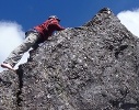
From there you can either climb directly up the other side.
Most people would have difficulty with this and a pack hauling rope would be required.
From memory its a ~4m climb?
we had several people in our party that weren't keen to climb out of the notch.
The other option is to descend the gully below the notch on the western side, then sidle around Mt Lot before
heading to the summit. This way isn't too difficult at all, with very minimal scrambling in the gully.
If you got to the top of Mt Anne, then I can't see why you'd have any difficulty here.
A few people weren't comfortable in the gully with their packs on so they passed them down a couple of sections.
This route was fairly well trodden.
A bit of cord for pack hauling would probably be handy either way.
Cheers
Aaron
Fri 05 Feb, 2010 12:02 pm
This is a bit naughty - but I got this off the web sometime ago.
I suspect it could be one of Dave Nobles?

- Notch.jpg (184.29 KiB) Viewed 13996 times
There are a number of descriptions you can find on the web by searching - from memory there is one of 4 people in the notch passing packs up each step in a relay.
Fri 05 Feb, 2010 12:28 pm
thanks guys. it was more of a general interest question than a technical one. im not particularly concerned of the climb myself, i just wanted to see what it looks like.
Cheers
Fri 05 Feb, 2010 2:55 pm
adj wrote:The other option is to descend the gully below the notch on the western side, then sidle around Mt Lot before
heading to the summit. This way isn't too difficult at all, with very minimal scrambling in the gully.
That's what I did last year. It was lousy weather and sod-all visibility, but I got through there without any trouble and without taking the pack off.
Fri 05 Feb, 2010 5:23 pm
Hard to get a good photo. Photo is looking down from the first climb out of the Notch. It is about 5 or 6 M I think.
I am late 40's short and over weight but was able to climb in and out of the Notch with out pack hauling.
I think it just depends on your experience on rock. I would rather do the Notch than all the boulder hopping, now that worries me.
I did the circuit last weekend
Roger
- Attachments
-

- IMG_0051 (Large).JPG (96.93 KiB) Viewed 13969 times
Mon 08 Feb, 2010 2:02 pm
Great shot Roger - wish we'd been able to see it before we went!
nakedape
Mon 08 Feb, 2010 8:57 pm
From what I can gather in the thread, it seems that this trek can get a bit icey in some places.
Is this during winter or does it actually get icey during summer?
Is it possible to attempt this hike during the winter?
I have never done a 'real' winter hike before. Is it a suitable route to start on?
Mon 08 Feb, 2010 9:02 pm
Climbing Mt Anne in winter can be hazardous as you are going up from the south = lots of shade, there's one section that is usually wet and it slopes towards the drop, so great care would be needed. I know it's been done in winter. If I were considering the Anne circuit in winter I'd have to keep in the forefront of my mind the prospects of turning back at some point, and remain aware of my perceptions on the surrounds. Oh crap, I'm getting old...
Mon 08 Feb, 2010 9:07 pm
benh wrote:From what I can gather in the thread, it seems that this trek can get a bit icey in some places.
Is this during winter or does it actually get icey during summer?
Is it possible to attempt this hike during the winter?
I have never done a 'real' winter hike before. Is it a suitable route to start on?
Having another read of your questions, I got a couple of inches of snow in Feb 2008 at shelf camp.
And I would say no this would probably not be a good excursion to learn about winter walking. Maybe the Walls would be a better option, at least you're only half a solid day from the car (but days are much shorter in Winter down here). Even then, we didn't quite get to Wild Dog Creek one winter, early '90s I think. A metre of snow, and more fell overnight.
Mon 08 Feb, 2010 9:28 pm
benh wrote:I have never done a 'real' winter hike before. Is it a suitable route to start on?
No.
Saying that its feasible to walk up to the Eliza Plateau / shelf's camp without too much trouble in winter.
However it is difficult to navigate up there under snow in the fog,
and the summit in Winter would generally requires some technical climbing skills and a rope to do it safely.
Best left to the experts.
I wouldn't turn up and attempt this as your first real winter hike.
Something like the Overland or Walls would be more suitable.. but you still need to be careful navigation
wise. Quite a few cases of people getting a bit lost up that way in winter after heavy snow falls and bad weather.
Cheers
Aaron
Tue 09 Feb, 2010 9:36 am
Content removed by poster
Last edited by
Ent on Tue 30 Nov, 2010 7:40 am, edited 1 time in total.
Tue 09 Feb, 2010 8:28 pm
If I wanted to do a "first real snow walk" in Tasmania, I'd to to Mt Field. Camp by K Col hut if the weather is good, camp by Newdegate Hut if the weather is not so good, and retire to the hut if it all gets too much.
JamesMc
Wed 10 Feb, 2010 12:22 pm
benh wrote:I have never done a 'real' winter hike before. Is it a suitable route to start on?
The closest I've been to the summit so far was an autumn day with a brilliant clear blue sky (as in my avatar) and a fair bit of snow on top.
I piked it halfway through the big boulder field on the last saddle. Trying to find a safe way through there, without being able to see the rocks . . . I wouldn't advise it. Walls, Field, the Overland - all would be better first goes than something like that.
Fri 26 Feb, 2010 12:55 pm
I am hoping to tackle the circuit over the long weekend, weather permitting. How long would you suggest the circuit takes? Is 3 days plenty of time to get through and climb a couple of the peaks?? I have not been to Mt Anne before, but I was comfortable enough climbing through the Western Arthurs, so I am looking forward to the challenge.
Mon 26 Apr, 2010 10:45 pm
pazzar wrote:I am hoping to tackle the circuit over the long weekend, weather permitting. How long would you suggest the circuit takes? Is 3 days plenty of time to get through and climb a couple of the peaks?? I have not been to Mt Anne before, but I was comfortable enough climbing through the Western Arthurs, so I am looking forward to the challenge.
Hi there,
I was going to ask this very same question - is three days enough to have a go at the circuit? Planning a three-day trek over the second weekend of May with a friend from the mainland. We are both quite fit (he runs marathons) and I have had fairly extensive walking experience in Tassie (Overland x2, Mt Field x5, Freycinet circuit, Maria x2, Adamson's, South Cape Rivulet x2 etc).
Don't mind a bit of snow, but how will this alter - or render impassable - the circuit (if at all)?
Also, what is the best idea re: car parking?
Any input would be much appreciated
Tue 27 Apr, 2010 10:35 am
3 days should be heaps of time to get everything you want done.
I have been through the circuit a couple of times & done Anne a couple of times as day walks.
My first time through the circuit a group of 6 of us did the whole circuit in 9 hours (ie. a day walk) + the road back to the car (in horizontal rain & cloud).
The second time me & a mate did it in 2 very comfortable days (just after Xmas 2008), minus going up Anne as we'd already been up twice & it wasn't our aim.
On this trip day 1 was to the Lonely Tarns with a side trip (half an hour) to Eve Peak & at least an hour on the summit of Mt Lot (see attached photo).
Day 2 was a side trip to Lots Wife (a couple of hours return including morning tea on the summit), on to Sarah Jane & a side trip up this (half an hour return) & out, again, including the 9km (?) walk along the road back to the car (a pleading request to a couple to give us a lift up the road falling on deaf ears

).

- Beautiful conditions from the summit of Mt Lot.
3 days should give you time to do all the peaks including Anne (or at least in summer it is ample time, make adjustments for shorter days).
ie.
Day 1 - to Shelf Camp, side-trip to summit Anne on the way through.
Day 2 - to the Lonely Tarns / Lake Picone (should have heaps of time to do Lots Wife as a side-trip).
Day 3 - out to the car (take a mountain bike & chain it up to a tree in the forest or take 2 cars tho, the road walk is tedious to say the least).
4 days at this time of year would also give you time to go up Schnells Ridge &/or visit Lake Judd.
Have fun out there & be aware that we are heading towards winter so the conditions can get awfully bad awfully quickly - be prepared for 4 seasons!
Cheers.
Stu.
Tue 27 Apr, 2010 11:13 am
A STUNNING Panorama Stu, I stretched it out full size over my two 24" monitors and totally lost focus on work for a few minutes!
Wed 28 Apr, 2010 9:14 pm
Hey Stu, thanks heaps for the info and advice - is a massive help. Really looking forward to next weekend now
Thu 29 Apr, 2010 1:53 am
Agreed Eggs, Great panorama Stu.
Thu 29 Apr, 2010 2:02 pm
Impressive photo Stu and equally impressive times for the circuit. The circuit is on my must do sometime soon - probably next summer now.
Cheers
Andrew
Thu 29 Apr, 2010 8:05 pm
a very long shot, but give me a yell if you see my camera; i lost it somewhere around the carpark a couple of months back

don't go out of your way though; i hope you have as much fun as i did!
Wed 05 May, 2010 10:49 pm
Will do Paul. Don't give up hope - I once got my full camera kit back about a month after I accidentally left it behind in the carpark at Charlotte Pass (Mt Kosciuszko circuit). Stranger things have happened

Will let you know if we come across anything.
Andrew.
Sat 24 Jul, 2010 6:26 pm
the notch as seen from shelf camp. looks daunting, we didn't attempt it this trip.
- Attachments
-

- The Notch from Shelf camp.
Mon 26 Jul, 2010 5:27 pm
I have some photo's on flickr of the notch. I put them there because I kept hearing about the notch but couldn't find any photos of it.
So here is the link if you're interested. There are a couple of small videos as well...taken on my camera though so not great video quality.
http://www.flickr.com/photos/taspicsvns ... 425564266/There is also another small climb after the notch. They are both fairly tame climbs. Just take your time and pack haul and it will be fine.
Love this walk!
Tue 27 Dec, 2011 11:02 pm
this thread has some great info, looking to do the 3 day circuit jan 6, 7, 8 with a couple friends, will report back
Tue 27 Dec, 2011 11:32 pm
I didn't think the Notch was that bad, there's a bit of exposure so best take a rope. I met a guy in Hobart who lost his pack over the edge and later retrieved it with Chapman's help. I managed to summit Mt Anne which was quite an effort for me, I don't like heights too much and there's tricky bit involving skirting over a slippery slab; I used the cracks in it to get over this bit.
Enjoy.
Sat 11 Feb, 2012 7:13 pm
frenchy_84 wrote:Can someone please post a photo of the difficult section of the notch? i have only done Mt Anne as a day trip so i havent seen the difficult section that may make some turn back?
i guess not......?
Sat 11 Feb, 2012 8:25 pm
After seeing some of these great photo's

I really think I've lost the plot even considering doing this circuit, but just in case I still go ahead with it can anyone tell me what the water situation is at shelf camp? Thanks.
Sun 12 Feb, 2012 6:10 am
Snowzone wrote:After seeing some of these great photo's

I really think I've lost the plot even considering doing this circuit, but just in case I still go ahead with it can anyone tell me what the water situation is at shelf camp? Thanks.
It's really not that hard.....
Water at shelf camp is usually reliable, several big pools in the rocks.
© Bushwalk Australia and contributors 2007-2013.