Page 1 of 1

Mt. Lorymer, Mt. Riana, Dial Range

PostPosted: Thu 25 Sep, 2008 11:23 am
by sthughes
Anyone know anything about Mt. Lorymer? Does it have a decent view, is it worth a look? I noticed a few things on the net mention the Mt. Lorymer "lookout' so I'm thinking perhaps it has a view?

What about Mt. Riana? Is there even a track? Does it have a view or are there too many trees? I can't seem to find anything on this one.

Is there anything else in the Dial Range worth a look? I've done pretty much everything north of a line from Mt. Duncan to Purtons Flats but nothing much in the south of the range. I'm after shorter walks sort of no more than 5-6 hours.

Re: Mt. Lorymer, Mt. Riana, Dial Range

PostPosted: Fri 26 Sep, 2008 8:05 pm
by Joe
Do you use OziExplorer? If so I have a map I calibrated up myself from forestry map of the area that shows all the walking tracks in the area. Lorymer would have an ok view if you get above the trees i would imagine. My map shows a definite track to the summit of Lorymer...but no tracks on Mt Riana. Mt Riana is actually on the other side of the Cookes Road which is the one you can drive out on after the Duncan carpark that brings you out in Riana township itself. So if there was a track it should be visible from this road as there is no way you would come in from the western side I wouldnt think,

Re: Mt. Lorymer, Mt. Riana, Dial Range

PostPosted: Fri 26 Sep, 2008 8:24 pm
by sthughes
No I don't have OziExplorer - only Mapsource and of course good ol Google Earth. I've got a pretty good idea of the route up Lorymer - it's on Tasmaps and Google Earth. I guess I'll have to go up to see if it's worth a look, still a peak bagged either way. :P
As for Riana I figured it would come off Ironcliff/Cookes Road but not sure where, if it exists at all - might have to have a drive through (not sure how good the road will be after all the rain but I can have a look). I have been through there before but I didn't see it - of course at the time I wasn't looking either. There also appears to be a road/track starting up the west side and terminating in bush in the middle of no where - made me wonder??
Anyway I might scoot up Lorymer tomorrow morning, check out Riana if possible and try and get back to Devonport in time for lunch and the big game!

Re: Mt. Lorymer, Mt. Riana, Dial Range

PostPosted: Fri 26 Sep, 2008 8:30 pm
by flyfisher
and try and get back to Devonport in time for lunch and the big game!


GO THE CATS !!!!!!!

FF

Re: Mt. Lorymer, Mt. Riana, Dial Range

PostPosted: Fri 26 Sep, 2008 8:34 pm
by sthughes
Oi - Thats unTasmanian - go the mighty Tassie Hawks!

(actually I'm an eagles supporter - but the Hawks are still a bird of prey and I hope they deal with the Cats like the Eagles in 92 and 94! Oh sorry to bring that up FF :P )

Re: Mt. Lorymer, Mt. Riana, Dial Range

PostPosted: Sat 27 Sep, 2008 1:48 pm
by sthughes
Well I went up Mount Lorymer this morning and fonud out first hand what it's like. I can tell you the "lookout" doesn't involve much looking out, in fact there aren't any views on the track (practically a road) at all. I left the car at the gate at 8am and was back before 10. I did take my MTB and ride the flat stuff for the first km or so. But apart from that it was very casual walking. Could do it in 2-2.5 hrs with ease all on foot (if you are desperate for a walk) Best suited to blind people really though! :P

Went for a drive to find a track up Mt. Riana - didn't find it but I piked out on Cookes Road when it started getting steep - the Yaris really isn't suitable for that stuff. Blew the indicator fuse on that track - I think it was trying to tell me to "get stuffed I'm not a 4x4". :roll:

Re: Mt. Lorymer, Mt. Riana, Dial Range

PostPosted: Thu 09 Oct, 2008 7:01 pm
by Speculator
taswaterfalls.com wrote:Do you use OziExplorer? If so I have a map I calibrated up myself from forestry map of the area that shows all the walking tracks in the area. Lorymer would have an ok view if you get above the trees i would imagine. My map shows a definite track to the summit of Lorymer...but no tracks on Mt Riana. Mt Riana is actually on the other side of the Cookes Road which is the one you can drive out on after the Duncan carpark that brings you out in Riana township itself. So if there was a track it should be visible from this road as there is no way you would come in from the western side I wouldnt think,


Thanks for the info on Lorymer STH, I was curious about it myself. Now I know not to bother. I'd hoped it might have good views of Gunns Plains, but I guess not. Actually, best views of the Gunns Plains are from Loytea Peak, you get a great sense of height from standing on the edge of that cliff looking down the plains.

Just for reference, this is the map BWT was referring to:

Image

L8r.

Re: Mt. Lorymer, Mt. Riana, Dial Range

PostPosted: Fri 10 Oct, 2008 10:48 am
by paulpeakbagger
I have climbed Mt Riana a couple of times, the last time in 2002. Both times we followed the road from near Mt Duncan south to the southeasten end of the Mt Riana ridge. We climbed up through some ferny going on to the ridgetop and followed the ridge to the summit. It is rocky and open going and you get views out to the west from a few spots. There is no track but the navigation is fairly easy.

Re: Mt. Lorymer, Mt. Riana, Dial Range

PostPosted: Sat 10 Apr, 2010 10:53 am
by isoma
Went up Mt Riana yesterday as the weather was too poor to consider Mt Ironstone. As noted above, no tracks. Most direct route IMO is to start from the next saddle south of Mt Duncan carpark on Cookes Rd. There was a big blaze on a tree painted red - dont know if this was for bushwalkers or from previous forestry operations?
Whilst up in the scrub looking for the summit I also stumbled across a geocache placed by one of the forum members on 15/05/08 - no names in the logbook though.

Re: Mt. Lorymer, Mt. Riana, Dial Range

PostPosted: Wed 26 Sep, 2012 9:12 pm
by Taurë-rana
Tortoise and I meandered up Mt Riana today. After practicing my 4WD skills in my Subi (not kidding, I would not want to be going along Hales Rd in a 2WD any more), we parked near the tree with the red blaze. We headed steadily up through forest full of manferns, and further up, a few interesting outcrops of rock with brilliant green moss and ferns on them. Once on top we wandered south until we ran out of ground that was going up, and figured we had reached the top. We had lunch with a nice view back across the Dial Range, no we didn't take several hours to get up, just don't like to rush out of bed in the morning!
Kathy Riana small.jpg
Climbing up past the manferns

We decided to make the trip a round one, so kept heading south along the ridge, occasionally picking up old yellow tapes, and finding some great views over the farmland and back to the mountains. More interesting rocky outcrops with ferns and moss and old man's beard added to the attractiveness of the walk. We also found some new shocking pink tapes which were very jarring leading us to consider the colours that perhaps should or shouldn't be used to tape a track - yellow, orange and blue don't seem offend the senses quite so much, perhaps because they are a bit closer to colours found naturally in the bush.

We followed the ridge until it petered out where we plunged left into a bit of a tangle of dead bracken fern and dead trees. Not far through this though we came out onto Hales Rd, just near a gate. It would probably have been a bit better to veer off the ridge slightly earlier as it was more open a bit further north. A pleasant 15 minute walk along the road, sussing out the best route through the washouts as we went brought us back to the car after an enjoyable and fairly leisurely 3 hours. This was another walk that was originally just an excuse to earn a point and enjoy the bush, but turned out to be a nice walk in its own right.

Once back in the car we continued to follow Hales Rd and then Cookes Rd, with one tricky washout giving me the opportunity to feel the Subi's AWD limited slip diff system and it felt very good! It was very nice to actually have the opportunity to use it as a 4WD. Not sure how long this road will be passable by anything other than a proper 4WD, and even they may be limited before long by a spot where the road has fallen away at the side, making it narrow.
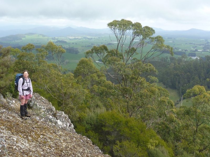
Me Riana small.jpg
A good place to enjoy the views