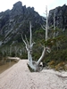
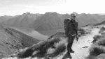
Mt Anne summit
Tasmania specific bushwalking discussion. Please avoid publishing details of access to sensitive areas with no tracks.
Mt Anne summit
![]() by devoswitch » Thu 09 Jan, 2014 6:33 am
by devoswitch » Thu 09 Jan, 2014 6:33 am
- Attachments
-
-
-
devoswitch - Athrotaxis cupressoides

- Posts: 409
- Joined: Mon 30 Dec, 2013 5:36 pm
- Region: Tasmania
- Gender: Male
-
devoswitch - Athrotaxis cupressoides
- Posts: 409
- Joined: Mon 30 Dec, 2013 5:36 pm
- Region: Tasmania
- Gender: Male
Re: Mt Anne summit
![]() by Strider » Thu 09 Jan, 2014 6:46 am
by Strider » Thu 09 Jan, 2014 6:46 am
-
Strider - Lagarostrobos franklinii

- Posts: 5875
- Joined: Mon 07 Nov, 2011 6:55 pm
- Location: Point Cook
- Region: Victoria
- Gender: Male
Re: Mt Anne summit
![]() by tibboh » Thu 09 Jan, 2014 7:03 am
by tibboh » Thu 09 Jan, 2014 7:03 am
-
tibboh - Athrotaxis selaginoides

- Posts: 1305
- Joined: Sat 26 Jan, 2013 3:54 pm
- Region: Tasmania
- Gender: Male
Re: Mt Anne summit
![]() by gayet » Thu 09 Jan, 2014 7:10 am
by gayet » Thu 09 Jan, 2014 7:10 am
i had planned a relaxed night or 2 at Lake Judd for this week! But work got in the way again. By the time I do get away I guess the weather will be foul. But better than the office!
- gayet
- Phyllocladus aspleniifolius

- Posts: 952
- Joined: Sat 12 Feb, 2011 8:01 pm
- Location: Wallan
- Region: Victoria
- Gender: Female
Re: Mt Anne summit
![]() by devoswitch » Thu 09 Jan, 2014 8:33 am
by devoswitch » Thu 09 Jan, 2014 8:33 am
-
devoswitch - Athrotaxis cupressoides
- Posts: 409
- Joined: Mon 30 Dec, 2013 5:36 pm
- Region: Tasmania
- Gender: Male
-
devoswitch - Athrotaxis cupressoides
- Posts: 409
- Joined: Mon 30 Dec, 2013 5:36 pm
- Region: Tasmania
- Gender: Male
-
Strider - Lagarostrobos franklinii
- Posts: 5875
- Joined: Mon 07 Nov, 2011 6:55 pm
- Location: Point Cook
- Region: Victoria
- Gender: Male
Re: Mt Anne summit
![]() by Graham51 » Sun 12 Jan, 2014 6:50 am
by Graham51 » Sun 12 Jan, 2014 6:50 am
- Attachments
-
- Mt Anne from Pandanni Shelf
- 045 (Custom).JPG (109.32 KiB) Viewed 16466 times
-
Graham51 - Lagarostrobos franklinii
- Posts: 3458
- Joined: Mon 11 Oct, 2010 7:19 pm
- Region: Tasmania
- Gender: Male
Re: Mt Anne summit
![]() by tibboh » Sun 12 Jan, 2014 7:06 am
by tibboh » Sun 12 Jan, 2014 7:06 am
Graham51 wrote: It's a great looking mountain whichever direction you view it from.
Sure is.....Tasmania's Matterhorn
-
tibboh - Athrotaxis selaginoides
- Posts: 1305
- Joined: Sat 26 Jan, 2013 3:54 pm
- Region: Tasmania
- Gender: Male
Re: Mt Anne summit
![]() by Strider » Sun 12 Jan, 2014 7:36 am
by Strider » Sun 12 Jan, 2014 7:36 am
I reckon Pindar's Peak would take that title!tibboh wrote:Graham51 wrote: It's a great looking mountain whichever direction you view it from.
Sure is.....Tasmania's Matterhorn
-
Strider - Lagarostrobos franklinii
- Posts: 5875
- Joined: Mon 07 Nov, 2011 6:55 pm
- Location: Point Cook
- Region: Victoria
- Gender: Male
Re: Mt Anne summit
![]() by gayet » Sun 12 Jan, 2014 8:42 am
by gayet » Sun 12 Jan, 2014 8:42 am
gayet wrote:Jealous!
i had planned a relaxed night or 2 at Lake Judd for this week! But work got in the way again. By the time I do get away I guess the weather will be foul. But better than the office!
Ok. Going out there on Tuesday. Hopefully I can get Lake Judd to myself for at least 1 night.
Given the forecast for the area, and that I have just weighed my pack and gear (2 nights food and some water included), I need some thoughts on ditching the heavy waterproof stuff. Pack comes in at ~21kg
I hope to get away with a easily squashable light thin waterproof (to some degree anyway) jacket and perhaps leave the pants behind as well. That should cut the load by over 1 kg.
Thoughts?
- gayet
- Phyllocladus aspleniifolius
- Posts: 952
- Joined: Sat 12 Feb, 2011 8:01 pm
- Location: Wallan
- Region: Victoria
- Gender: Female
Re: Mt Anne summit
![]() by Strider » Sun 12 Jan, 2014 9:06 am
by Strider » Sun 12 Jan, 2014 9:06 am
Perhaps post a gear list in a separate thread for critique? You must be able to lose some weight somewhere.
-
Strider - Lagarostrobos franklinii
- Posts: 5875
- Joined: Mon 07 Nov, 2011 6:55 pm
- Location: Point Cook
- Region: Victoria
- Gender: Male
Re: Mt Anne summit
![]() by gayet » Sun 12 Jan, 2014 9:22 am
by gayet » Sun 12 Jan, 2014 9:22 am
- gayet
- Phyllocladus aspleniifolius
- Posts: 952
- Joined: Sat 12 Feb, 2011 8:01 pm
- Location: Wallan
- Region: Victoria
- Gender: Female
-
Strider - Lagarostrobos franklinii
- Posts: 5875
- Joined: Mon 07 Nov, 2011 6:55 pm
- Location: Point Cook
- Region: Victoria
- Gender: Male
Re: Mt Anne summit
![]() by biggbird » Sun 12 Jan, 2014 10:33 am
by biggbird » Sun 12 Jan, 2014 10:33 am
- biggbird
- Phyllocladus aspleniifolius
- Posts: 763
- Joined: Wed 25 Apr, 2012 10:43 am
- Region: Tasmania
- Gender: Male
Re: Mt Anne summit
![]() by gayet » Sun 12 Jan, 2014 11:26 am
by gayet » Sun 12 Jan, 2014 11:26 am
- gayet
- Phyllocladus aspleniifolius
- Posts: 952
- Joined: Sat 12 Feb, 2011 8:01 pm
- Location: Wallan
- Region: Victoria
- Gender: Female
Re: Mt Anne summit
![]() by tibboh » Sun 12 Jan, 2014 4:34 pm
by tibboh » Sun 12 Jan, 2014 4:34 pm
-
tibboh - Athrotaxis selaginoides
- Posts: 1305
- Joined: Sat 26 Jan, 2013 3:54 pm
- Region: Tasmania
- Gender: Male
Re: Mt Anne summit
![]() by devoswitch » Sun 12 Jan, 2014 4:56 pm
by devoswitch » Sun 12 Jan, 2014 4:56 pm
Graham51 wrote:I went up there via NE Ridge, getting to the summit on Friday. We had three days of magnificent weather as well. It's a great looking mountain whichever direction you view it from.
It sure is a really good looking mountain. I'm interested in the way you went up there. While descending mount Eliza and looking over at the ridge to the west of Mt anne I noticed a large cave just below the ridge line. Has anyone else noticed this before.
-
devoswitch - Athrotaxis cupressoides
- Posts: 409
- Joined: Mon 30 Dec, 2013 5:36 pm
- Region: Tasmania
- Gender: Male
Re: Mt Anne summit
![]() by wayno » Mon 13 Jan, 2014 7:59 am
by wayno » Mon 13 Jan, 2014 7:59 am
gayet wrote:I am very much of the view that the lightweight "spray" type jacket will handle the forecast - obviously if that changes for the worse I'll reconsider. The pants can go. The down vest can go as a long sleeved merino and fleece will suffice (already in). I could swap the Goondie out for the Terra Nova but the goondie is more comfortable. I have been trying to get out there for months now. I might finally make it!
you actually trust forecasts? I take them with a grain of salt and take a bit more gear than the forecast suggests i need
-
wayno - Lagarostrobos franklinii
- Posts: 8685
- Joined: Sun 19 Jun, 2011 7:26 am
- Location: NZ
- Region: New Zealand
- Gender: Male
Re: Mt Anne summit
![]() by Joomy » Wed 15 Jan, 2014 10:57 pm
by Joomy » Wed 15 Jan, 2014 10:57 pm
Graham51 wrote:I went up there via NE Ridge, getting to the summit on Friday. We had three days of magnificent weather as well. It's a great looking mountain whichever direction you view it from.
Wow! Never seen a photo from that Aspect before. It looks even more impressive if possible.
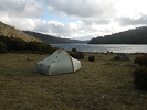
From waking up on shelf camp with the mists revealing the valley below and our first good view of Anne through to swimming next to our campsite at the lonely tarns in the still, hot evening of the following day is probably the most perfect walking experience I've ever had.
- Joomy
- Phyllocladus aspleniifolius
- Posts: 601
- Joined: Tue 22 May, 2012 6:40 pm
- Region: Australian Capital Territory
- Gender: Male
Re: Mt Anne summit
![]() by stepbystep » Thu 16 Jan, 2014 7:48 am
by stepbystep » Thu 16 Jan, 2014 7:48 am
Joomy wrote:From waking up on shelf camp with the mists revealing the valley below and our first good view of Anne through to swimming next to our campsite at the lonely tarns in the still, hot evening of the following day is probably the most perfect walking experience I've ever had.
I always like to hear stories like that. Anne beguiles many a walker!
-

stepbystep - Lagarostrobos franklinii
- Posts: 7625
- Joined: Tue 19 May, 2009 10:19 am
- Location: Street urchin
- Region: Tasmania
- Gender: Male
Re: Mt Anne summit
![]() by devoswitch » Thu 16 Jan, 2014 6:06 pm
by devoswitch » Thu 16 Jan, 2014 6:06 pm
-
devoswitch - Athrotaxis cupressoides
- Posts: 409
- Joined: Mon 30 Dec, 2013 5:36 pm
- Region: Tasmania
- Gender: Male
Re: Mt Anne summit
![]() by tibboh » Fri 17 Jan, 2014 6:26 am
by tibboh » Fri 17 Jan, 2014 6:26 am
viewtopic.php?f=3&t=8748
-
tibboh - Athrotaxis selaginoides
- Posts: 1305
- Joined: Sat 26 Jan, 2013 3:54 pm
- Region: Tasmania
- Gender: Male
Re: Mt Anne summit
![]() by devoswitch » Fri 17 Jan, 2014 8:59 am
by devoswitch » Fri 17 Jan, 2014 8:59 am
-
devoswitch - Athrotaxis cupressoides
- Posts: 409
- Joined: Mon 30 Dec, 2013 5:36 pm
- Region: Tasmania
- Gender: Male
Re: Mt Anne summit
![]() by icefest » Sat 18 Jan, 2014 7:26 am
by icefest » Sat 18 Jan, 2014 7:26 am
-

icefest - Lagarostrobos franklinii
- Posts: 4517
- Joined: Fri 27 May, 2011 11:19 pm
- Location: www.canyoninginvictoria.org
- Region: Victoria
Re: Mt Anne summit
![]() by SergejD » Wed 29 Jan, 2014 6:31 pm
by SergejD » Wed 29 Jan, 2014 6:31 pm
- SergejD
- Nothofagus gunnii

- Posts: 13
- Joined: Thu 10 Oct, 2013 8:02 pm
- Region: Other Country
- Gender: Male
Re: Mt Anne summit
![]() by lajs » Sat 31 Oct, 2015 7:56 pm
by lajs » Sat 31 Oct, 2015 7:56 pm
Alternatively, before the track begins to contour round the right hand side of the summit block follow the left side instead where a gully with less exposure leads to the top.
(From http://bushwalk.com/wiki/index.php/Anne,_Mount)
Can anyone comment on this alternative route? In terms of locating and following the track and difficulty of the ascent?
I am not particularly fond of free climbing, exposure, narrow ledges etc. (I am not completely incapable but prefer to avoid).
Any pictures or a map showing the alternative route would be greatly appreciated.
- lajs
- Nothofagus gunnii
- Posts: 14
- Joined: Sat 18 Oct, 2014 8:40 pm
- Region: Queensland
Re: Mt Anne summit
![]() by devoswitch » Sun 01 Nov, 2015 4:43 am
by devoswitch » Sun 01 Nov, 2015 4:43 am
-
devoswitch - Athrotaxis cupressoides
- Posts: 409
- Joined: Mon 30 Dec, 2013 5:36 pm
- Region: Tasmania
- Gender: Male
Re: Mt Anne summit
![]() by Tortoise » Sun 01 Nov, 2015 11:13 am
by Tortoise » Sun 01 Nov, 2015 11:13 am
lajs wrote:I have read about an alternative route to the summit of Mt Anne:Alternatively, before the track begins to contour round the right hand side of the summit block follow the left side instead where a gully with less exposure leads to the top.
(From http://bushwalk.com/wiki/index.php/Anne,_Mount)
Can anyone comment on this alternative route? In terms of locating and following the track and difficulty of the ascent?
I am not particularly fond of free climbing, exposure, narrow ledges etc. (I am not completely incapable but prefer to avoid).
Any pictures or a map showing the alternative route would be greatly appreciated.
We went looking for it last summer, with a vague description of 'cairns in a gully', and 'not airy at all'. We found a sort of gully, with cairns leading into it on the west side of Anne, but I'm convinced that wasn't it. It leads to rock walls, which I only got up with considerable help and difficulty. So much so that we decided to try the conventional route on the way down. I think the 'easy' route must be on the north side, up from Pandani Shelf, or at least closer to that than we tried. Maybe start a separate thread to get the specifics. I still hope to find it one day.
-

Tortoise - Lagarostrobos franklinii
- Posts: 5343
- Joined: Sat 28 Jan, 2012 9:31 pm
- Location: NW Tasmania
- Region: Tasmania
- Gender: Female
Who is online
Users browsing this forum: No registered users and 33 guests