Hi all,
Looking to head up Western Creek Track next week. Can anyone advise on:
- Condition of Westrope Road
- Condition of road to the carpark
- Any downed trees after the recent rough weather..?? (Road & Tracks)
- what the scramble up Mt Ironstone is like from this side..??
Any info greatly appreciated.
Rgds,
Thomas.
Western Creek Track
Forum rules
Tasmania specific bushwalking discussion. Please avoid publishing details of access to sensitive areas with no tracks.
Tasmania specific bushwalking discussion. Please avoid publishing details of access to sensitive areas with no tracks.
20 posts
• Page 1 of 1
Western Creek Track
![]() by Thomas » Thu 21 Aug, 2014 7:05 pm
by Thomas » Thu 21 Aug, 2014 7:05 pm
-

Thomas - Athrotaxis cupressoides

- Posts: 130
- Joined: Wed 14 Jul, 2010 8:41 am
- Region: Tasmania
- Gender: Male
Re: Western Creek Track
![]() by Tortoise » Thu 21 Aug, 2014 8:38 pm
by Tortoise » Thu 21 Aug, 2014 8:38 pm
Hi Thomas,
Westrope Rd was fine and dandy for 2wd earlier this year, don't know about recent storm damage.
I parked on westrope Rd rather than follow the 4wd track for Western Ck track, though somebody more enthusiastic would have taken my subaru up it - a few ruts near the beginning, and starting to overgrow in places iirc.
I went up Ironstone via Syd's track and stumbled on a pad/cairned route that reached the plateau a little east of the summit (not quite like it's represented on the LISTmap.) I just followed my nose up scree fields, being easier than scrub. I haven't gone across from there to Western Cr track yet. My choice of Syd's over Western was influenced by a higher starting point, and not having to worry re the creek being too high to cross above the waterfall.
Have you tried searching this site? (Not always easy to find stuff, though) There were some comments somewhere about Ironstone from the W Ck track i vaguely remember.
-

Tortoise - Lagarostrobos franklinii

- Posts: 5343
- Joined: Sat 28 Jan, 2012 9:31 pm
- Location: NW Tasmania
- Region: Tasmania
- Gender: Female
Re: Western Creek Track
![]() by Thomas » Thu 21 Aug, 2014 10:19 pm
by Thomas » Thu 21 Aug, 2014 10:19 pm
Thx Tortoise - I will do a search. I did look at Syds Track on Open Street Map...is that the one from the end of Westrope Rd..??
Rgds,
Thomas.
Rgds,
Thomas.
-
Thomas - Athrotaxis cupressoides
- Posts: 130
- Joined: Wed 14 Jul, 2010 8:41 am
- Region: Tasmania
- Gender: Male
Re: Western Creek Track
![]() by Graham51 » Thu 21 Aug, 2014 10:21 pm
by Graham51 » Thu 21 Aug, 2014 10:21 pm
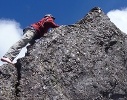
I climbed Mt Ironstone from Whiteleys Hut a few years ago. We had deep snow drifts to contend with in many places but didn't have too much trouble finding a way up. The part I didn't like was this creek crossing. Even with the wire, with the river in flood, it was treacherous and, in retrospect, I shouldn't really have crossed it.
- Attachments
-
- 9325_1199387780974_7224482_n[1] (Custom).jpg (31.91 KiB) Viewed 11303 times
-

Graham51 - Lagarostrobos franklinii
- Posts: 3458
- Joined: Mon 11 Oct, 2010 7:19 pm
- Region: Tasmania
- Gender: Male
Re: Western Creek Track
![]() by Thomas » Thu 21 Aug, 2014 10:35 pm
by Thomas » Thu 21 Aug, 2014 10:35 pm
Thx Graham51 - keen to get to the top of ironstone if possible. I believe it's best to stay off the 'Loop Track' ...?? Other posts say it's a nasty walk..??
Rgds,
Thomas
Rgds,
Thomas
-
Thomas - Athrotaxis cupressoides
- Posts: 130
- Joined: Wed 14 Jul, 2010 8:41 am
- Region: Tasmania
- Gender: Male
Re: Western Creek Track
![]() by Thomas » Sat 23 Aug, 2014 7:47 pm
by Thomas » Sat 23 Aug, 2014 7:47 pm
Hi all,
Just wondering - if i'm only after the climb of Mt Ironstone, would I be best to consider Syd's Track..??
Rgds,
Thomas.
Just wondering - if i'm only after the climb of Mt Ironstone, would I be best to consider Syd's Track..??
Rgds,
Thomas.
-
Thomas - Athrotaxis cupressoides
- Posts: 130
- Joined: Wed 14 Jul, 2010 8:41 am
- Region: Tasmania
- Gender: Male
Re: Western Creek Track
![]() by Tortoise » Sun 24 Aug, 2014 7:56 pm
by Tortoise » Sun 24 Aug, 2014 7:56 pm
Hi Thomas,
The following is a useful website, and has details re Syd's track. Westrope Road keeps going past the turn off to Syd's, to the northern approach to Mother Cummings Peak (and other forestry tracks)
http://tastracks.webs.com/greatwesterntiers.htm#587098178
I personally wouldn't rely on the Western Creek track this time of year, because of the creek crossing. The majority of people i've heard of going up Ironstone go from Syd's (the easiest as far as I could figure) or the Meander Valley (lots of discussion here re road status there).
Waiting for others to comment...
Thx Tortoise - I will do a search. I did look at Syds Track on Open Street Map...is that the one from the end of Westrope Rd..??
The following is a useful website, and has details re Syd's track. Westrope Road keeps going past the turn off to Syd's, to the northern approach to Mother Cummings Peak (and other forestry tracks)
http://tastracks.webs.com/greatwesterntiers.htm#587098178
I personally wouldn't rely on the Western Creek track this time of year, because of the creek crossing. The majority of people i've heard of going up Ironstone go from Syd's (the easiest as far as I could figure) or the Meander Valley (lots of discussion here re road status there).
Waiting for others to comment...
-
Tortoise - Lagarostrobos franklinii
- Posts: 5343
- Joined: Sat 28 Jan, 2012 9:31 pm
- Location: NW Tasmania
- Region: Tasmania
- Gender: Female
Re: Western Creek Track
![]() by Thomas » Sun 24 Aug, 2014 8:11 pm
by Thomas » Sun 24 Aug, 2014 8:11 pm
Hey Tortoise - Decided to go with Syds...that's if I don't change my mind & tackle mother cummings..!! The only attraction to WCT are the cascades & falls for pictures... 
Thx for the info - appreciate it.
Rgds,
Thomas.
Thx for the info - appreciate it.
Rgds,
Thomas.
-
Thomas - Athrotaxis cupressoides
- Posts: 130
- Joined: Wed 14 Jul, 2010 8:41 am
- Region: Tasmania
- Gender: Male
Re: Western Creek Track
![]() by Tortoise » Sun 24 Aug, 2014 8:33 pm
by Tortoise » Sun 24 Aug, 2014 8:33 pm
Actually, I went up Mother Cummings one day (played on the plateau to the south of the peaky bit, where the high point is), car camped the night and went up Syd's to Ironstone the next day.
Lovely falls on Western Creek...
Lovely falls on Western Creek...
-
Tortoise - Lagarostrobos franklinii
- Posts: 5343
- Joined: Sat 28 Jan, 2012 9:31 pm
- Location: NW Tasmania
- Region: Tasmania
- Gender: Female
Re: Western Creek Track
![]() by Thomas » Sun 24 Aug, 2014 9:09 pm
by Thomas » Sun 24 Aug, 2014 9:09 pm
Arrgghh.....now you've got me thinking on WCT again....!!!!!!
Whats the cairned route like across the plateau to ironstone....??? (Syds track)
Rgds,
T.
Whats the cairned route like across the plateau to ironstone....??? (Syds track)
Rgds,
T.
-
Thomas - Athrotaxis cupressoides
- Posts: 130
- Joined: Wed 14 Jul, 2010 8:41 am
- Region: Tasmania
- Gender: Male
Re: Western Creek Track
![]() by Tortoise » Sun 24 Aug, 2014 9:21 pm
by Tortoise » Sun 24 Aug, 2014 9:21 pm
Thomas wrote:Arrgghh.....now you've got me thinking on WCT again....!!!!!!
Whats the cairned route like across the plateau to ironstone....??? (Syds track)
Rgds,
T.
Sorry, Thomas - rather naughty of me.
Can you afford 2 trips? If heaps of water around, go for the falls, not being committed to get across Western creek in high water. Maybe do Ironstone a different time when not heaps of water if necessary. Or do Ironstone first if that's the real prize (it is!) and weather permits.
Can't quite remember - Syd's takes you onto the plateau, and cairns go a bit further, but not all the way. I just went by map and aimed for the path of least resistance (with GPS backup) - which led me to stumble on the other route I mentioned earlier (on LISTmap). I wouldn't want to rely on dodgy compass readings if the mist rolled in. It was nice to know i could find my way back home to Syd's track.
-
Tortoise - Lagarostrobos franklinii
- Posts: 5343
- Joined: Sat 28 Jan, 2012 9:31 pm
- Location: NW Tasmania
- Region: Tasmania
- Gender: Female
Re: Western Creek Track
![]() by pazzar » Mon 25 Aug, 2014 7:32 am
by pazzar » Mon 25 Aug, 2014 7:32 am
If you like waterfalls, then I can highly recommend the Smoko Creek track (Starts at the same place as Mother Cummings). Well marked at least until the plateau, and plenty of waterfalls to keep you entertained. There is a creek crossing on it up high that could be a little bit dodgy if the water is high though. I was there 18 months ago, but not sure of the road quality since then. You have to cross a rather large creek at the start since the bridge is down.
"It's not what you look at that matters, it's what you see."
-
pazzar - Lagarostrobos franklinii
- Posts: 2657
- Joined: Thu 09 Jul, 2009 5:22 pm
- Location: Hobart
- Region: Tasmania
- Gender: Male
Re: Western Creek Track
![]() by bauera » Tue 26 Aug, 2014 9:23 pm
by bauera » Tue 26 Aug, 2014 9:23 pm
Thomas, I was on WCT a couple weeks back. It was fine. The creek crossing at the waterfall was nowhere near as high as in the photo Graham51 (I think) posted but it was after a night of rain and snow (fresh snow was beautiful, by the way). It really was not much of a hazard. And you get the bonus of those lovely creekside views. We parked at Westrope Rd but track up to park area is only couple hundred metres and would be okay for careful 2wd. I've only walked Syd's once, many years ago, so poor memory. Just remember a lot of fog on Ironstone and difficulty following cairns as a result. You might be able to do a circuit, but personally I would start with Syds and come out WCT because start of WCT is easy to find from Whiteleys hut, whereas for Syds I have no reference for finding the start on plateau.
- bauera
- Athrotaxis cupressoides
- Posts: 106
- Joined: Sun 14 Dec, 2008 1:32 pm
- Region: Tasmania
Re: Western Creek Track
![]() by Thomas » Tue 26 Aug, 2014 9:34 pm
by Thomas » Tue 26 Aug, 2014 9:34 pm
Thx bauera .... invaluable info...!
I certainly considered a loop walk, and with the start of the two tracks only being 1 km apart at their starting point, it's certainly manageable. ! I think for memory, I measured around the 13km mark for the loop....
thx again,
T.
I certainly considered a loop walk, and with the start of the two tracks only being 1 km apart at their starting point, it's certainly manageable. ! I think for memory, I measured around the 13km mark for the loop....
thx again,
T.
-
Thomas - Athrotaxis cupressoides
- Posts: 130
- Joined: Wed 14 Jul, 2010 8:41 am
- Region: Tasmania
- Gender: Male
Re: Western Creek Track
![]() by ozidave » Sun 31 Aug, 2014 3:45 pm
by ozidave » Sun 31 Aug, 2014 3:45 pm
G'day,
We went up Syd's on Saturday and cut across to Whiteley's hut (by managing to lose the track in heavy fog and instead go straight across on a compass bearing) where we camped. We came down Western Creek Track on Sunday with no problems. The creek crossing was half way up our boots.
There's a few trees down on the walking track but all the ones on the road have been cleared up.
- ozidave
- Nothofagus gunnii

- Posts: 18
- Joined: Wed 24 Apr, 2013 8:29 pm
- Region: Tasmania
- Gender: Male
Re: Western Creek Track
![]() by Thomas » Thu 04 Sep, 2014 6:38 pm
by Thomas » Thu 04 Sep, 2014 6:38 pm
Thx for the post Ozidave. I headed up last thursday with my Brother - will post some notes soon - struck the same issue with low cloud & had to abandon Ironstone climb. Looking to do Syds next Saturday - what's the track like..??
Regards
T.
Regards
T.
-
Thomas - Athrotaxis cupressoides
- Posts: 130
- Joined: Wed 14 Jul, 2010 8:41 am
- Region: Tasmania
- Gender: Male
Re: Western Creek Track
![]() by Thomas » Thu 16 Oct, 2014 6:08 pm
by Thomas » Thu 16 Oct, 2014 6:08 pm
Hi all,
Well - did manage to get up Western Creek on the 28th August - wandered around, took some snaps & headed back down. Western Creek was interesting.... .... Whiteleys Hut was rustic..!
Weather was average @ best so didn't really have a crack @ Ironstone on this occasion.
Attached some snaps from the day.
Rgds,
Thomas.
Well - did manage to get up Western Creek on the 28th August - wandered around, took some snaps & headed back down. Western Creek was interesting....
Weather was average @ best so didn't really have a crack @ Ironstone on this occasion.
Attached some snaps from the day.
Rgds,
Thomas.
- Attachments
-
-
-
-
Thomas - Athrotaxis cupressoides
- Posts: 130
- Joined: Wed 14 Jul, 2010 8:41 am
- Region: Tasmania
- Gender: Male
Re: Western Creek Track
![]() by Tortoise » Thu 16 Oct, 2014 6:13 pm
by Tortoise » Thu 16 Oct, 2014 6:13 pm
Hi Thomas,
thanks for the post. Sounds very familiar. I had 2 or 3 times up there in cloud before the perfect day for Ironstone - which was worth waiting for! I was very glad of the wire a couple of times to help the creek crossing. Wouldn't be any fun going over the falls...
thanks for the post. Sounds very familiar. I had 2 or 3 times up there in cloud before the perfect day for Ironstone - which was worth waiting for! I was very glad of the wire a couple of times to help the creek crossing. Wouldn't be any fun going over the falls...
-
Tortoise - Lagarostrobos franklinii
- Posts: 5343
- Joined: Sat 28 Jan, 2012 9:31 pm
- Location: NW Tasmania
- Region: Tasmania
- Gender: Female
Re: Western Creek Track
![]() by Thomas » Thu 16 Oct, 2014 7:02 pm
by Thomas » Thu 16 Oct, 2014 7:02 pm
Hmmmm...true about the falls below - ouch would be an understatement..! That's my bro in the last picture..!
Can I ask - which approach did you finally use to reach the summit of Ironstone..?
Rgds,
T.
Can I ask - which approach did you finally use to reach the summit of Ironstone..?
Rgds,
T.
-
Thomas - Athrotaxis cupressoides
- Posts: 130
- Joined: Wed 14 Jul, 2010 8:41 am
- Region: Tasmania
- Gender: Male
Re: Western Creek Track
![]() by Tortoise » Thu 16 Oct, 2014 7:31 pm
by Tortoise » Thu 16 Oct, 2014 7:31 pm
Tortoise wrote:Can't quite remember - Syd's takes you onto the plateau, and cairns go a bit further, but not all the way. I just went by map and aimed for the path of least resistance (with GPS backup) - which led me to stumble on the other route I mentioned earlier (on LISTmap). I wouldn't want to rely on dodgy compass readings if the mist rolled in. It was nice to know i could find my way back home to Syd's track.
Can I ask - which approach did you finally use to reach the summit of Ironstone..?
Unfortunately i didn't take pics in the right place, and
BUT - I crossed the open valley/plain, just aiming towards what looked like the easiest route to the top of the Ironstone plateau. To get there, i tended to go for boulder fields, which were much quicker than dodging scrub. I came up onto the plateau a fair way east of the summit, and found a big cairn on the top on the way to the summit that marked the pad back down that I followed - grassier than my route up. Following that I found the cairned route that becomes a track down to the Meander Valley. (Roughly marked on theLISTMAP - though i'm sure it still came up east of the summit, not just to the west as you see when you zoom in) I just left it wherever it seemed to easiest to head back to Syd's.
Not sure if that helps. I'm scratching my head over your pics on the Mt Ironstone thread. My memory is full of holes, but i think i aimed much further east than you seem to be - maybe (only maybe) about the middle of the line of cliffs on the left hand side of your pic with the tree trunk marker. On the other hand it might have been the right hand end of them.
-
Tortoise - Lagarostrobos franklinii
- Posts: 5343
- Joined: Sat 28 Jan, 2012 9:31 pm
- Location: NW Tasmania
- Region: Tasmania
- Gender: Female
20 posts
• Page 1 of 1
Who is online
Users browsing this forum: No registered users and 52 guests