Page 1 of 1
LIST Open Data - QGIS Style Sheets
Posted: Sat 02 Jun, 2018 11:11 am
by tastrax
Hi Folks,
I am doing some work in QGIS 3.0 using the free data available from the LIST Open data site
https://listdata.thelist.tas.gov.au/opendata/If anyone is interested I would be happy to share style sheets for layers to make everyone's life a bit easier and to encourage use of QGIS.
Style sheets allow you change the line colours, thickness etc at different zoom levels as well as change when labels appear and disappear. A few samples might also help you get the hang of styles, labelling and QGIS in general.
I have attached one for the contours layer (in a zip file).
Re: LIST Open Data - QGIS Style Sheets
Posted: Sat 02 Jun, 2018 1:42 pm
by neilmny
Hi Phil,
I haven't upgraded to QGIS 3 as yet and I'd like to ask a couple of questions I hope you don't mind.
Currently using 2.18.19.1 and I was wondering if 3.3 can be set up without uninstalling 2.18.
My concern is that I have 2.18 just the way I want it and I don't want upgrading to send me back to the start set up wise.
The impression I get from what I read is that 3.3 is a whole new ball game....is that the case?
It's a fantastic program and I've been using it since 2.14??? or so thanks in advance.
Neil.
Re: LIST Open Data - QGIS Style Sheets
Posted: Sat 02 Jun, 2018 4:28 pm
by tastrax
Yep, you can load 3 and it will go in a completely separate installation folder, You can also open any old projects in 3.0 BUT if you style things with any of the new styling features then you may no longer be able to open the projects in 2.18.
If you do set up 3.0 then you can also start getting it up to the same spec as your 2.18 with plugins etc. I usually run two versions at any one time.
The style file will work in 2.18 or 3.0 as its nothing special.
Re: LIST Open Data - QGIS Style Sheets
Posted: Sat 02 Jun, 2018 4:36 pm
by neilmny
Great news thanks Phil.
That's what I would like to do, run both until I have V3 up to speed (it's already at V3.0.3).
I'll have a look and see if your style file works with my VicData contours.
Thanks again. Neil.
PS. Your style worked but I had to change the data field to "ALTITUDE" to match my Vic Data.
Here is my contours style that I use. Sort of same only different.
I realise this is not the same data source but the concepts are the same. just need to match the data fields to get them working.
Re: LIST Open Data - QGIS Style Sheets
Posted: Sat 02 Jun, 2018 8:41 pm
by tastrax
No worries neilmy - happy to help out with anything QGIS. Still learning, but using it on a regular basis for a few organisations across the country so style files by state are a welcome time saver!
Do you know that if you name the qml the same as the corresponding shp file and keep them in the same directory, it will apply the style file every time you open the layer! That also saves time!
Re: LIST Open Data - QGIS Style Sheets
Posted: Sun 03 Jun, 2018 7:44 am
by neilmny
tastrax wrote:.............Do you know that if you name the qml the same as the corresponding shp file and keep them in the same directory, it will apply the style file every time you open the layer! That also saves time!
No I didn't.....and.....wow that is a fast way to add a styled layer

I have a whole bunch of styles for each layer type that I constantly upgrade as I decide I need new features to display or discover a way to display features better.
Those styles are in one folder and I just add them to a new layer as I go. If I could ever decide that enough tweeks are enough this method would be great.
If I just named say a roads layer "Roads" it would work too, but I generally give the layers some sort of regional identity. I have only developed maps for chunks of bushwalking interest like the Grampians, ANP and Kosciuszko NP (it links to the ANP) and the shape files are named similarly.
ie. KNP Points, KNP Roads, KNP OSM Polygons, KNP Contours 20M etc. etc.
It's a lot of fun and the various zoomed in maps have proven very useful out in the sticks.
Another thing I've found is that the OSM data (basis for the roads and points and some polygons in my maps) proves to be quite accurate on the ground.
Re: LIST Open Data - QGIS Style Sheets
Posted: Sun 03 Jun, 2018 11:24 am
by CasualNerd
I haven't downloaded yet, but this will allow me to darken contour lines etc to make them easier to read when printed right ?
I've barely played with QGIS, this is very helpful thanks.
Re: LIST Open Data - QGIS Style Sheets
Posted: Sun 03 Jun, 2018 1:02 pm
by neilmny
Yes Phil's contour style actually changes the line thickness based on elevation which makes the line appear darker.
Mine does too but there is an issue with text (labelling).
I've discovered that my contour style doesn't work correctly in QGIS 3.0.3. The style has text scaling (pixel) based on zoom level.
This does not work in version 3 and I've spent about 3 hours trying to fix it to no avail.
The style works correctly in version 2.18 and most likely earlier versions.
Re: LIST Open Data - QGIS Style Sheets
Posted: Sun 03 Jun, 2018 2:11 pm
by andrewp
Hi Phil,
I would appreciate your QGIS style sheets. I am using v3.0.3. I am using QGIS with VIC shapefile data to create maps for rogaining (a bit like orienteering).
The TAS shapefiles are by municipality. Do you combine them, or just have a layer for each?
Also could you suggest which layers are most useful for bushwalking maps.
Re: LIST Open Data - QGIS Style Sheets
Posted: Sun 03 Jun, 2018 2:55 pm
by tastrax
Hi andrewp,
Some of the layers in list open data are statewide - others are just by municipality. You can merge them if you want to but be aware they can become quite large and cumbersome. Style sheets make it pretty quick either way. As to which layers - that's up to you but contours, hydrology and the walking tracks out of the road layer would be the most useful.
neilmy - I will grab some vic layers and check out your style and see if we can get the scaling resolved in 3. Do you have a link for the contours layer anywhere?
Re: LIST Open Data - QGIS Style Sheets
Posted: Sun 03 Jun, 2018 3:40 pm
by tastrax
neilmy - try replacing $scale with @map_scale in version 3
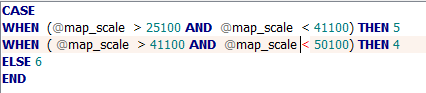
- mapscale.PNG (4.29 KiB) Viewed 24548 times
Re: LIST Open Data - QGIS Style Sheets
Posted: Sun 03 Jun, 2018 3:45 pm
by neilmny
Hi Phil,
This is a zip of the 20m contour shape file for part of the Eildon NP.
There are some 10 metre contours that I just excluded using the qml file attach above.
CRS is GDA94 although it seems V3.0.3 doesn't need to know that

It is Vic Data and available under CC$ license - Copyright © The State of Victoria, Department of Environment, Land, Water & Planning 2016.
License - Creative Commons Attribution 4.0 International
The web site for Vic Data is -
https://www.data.vic.gov.au/"Data.Vic is the place to discover and access Victorian government open data
You will find data that Victorian government departments and agencies have opened and made available to the public.
You can use it anyway you like build apps and tools, use it for research, gain insights and understanding."
Re: LIST Open Data - QGIS Style Sheets
Posted: Sun 03 Jun, 2018 3:46 pm
by neilmny
tastrax wrote:neilmny - try replacing $scale with @map_scale in version 3........
OK Phil, I tried map_Scale but not @map_scale I'll see how it goes.
.............
Much appreciated Phil thank you.
Excellent....that was the secret. Proportional text scaling is working in V3.0.3.
I've attached my style versions for Vic Data watercourses (VIC Hydro_whole state_CC4) and 20m Contours (Contours 10_20m_whole state_CC4).
Re: LIST Open Data - QGIS Style Sheets
Posted: Sat 09 Jun, 2018 10:20 am
by tastrax
I had a chance to do a first pass on the LIST Hydrology areas this morning. Styles only - no labelling or zoom layering
Re: LIST Open Data - QGIS Style Sheets
Posted: Tue 12 Jun, 2018 1:50 pm
by CasualNerd
tastrax, I know there were some beginner QGIS tutorial PDF's on the wildcare server and a LIST web services guide but they're not very helpful now I've installed QGIS 3.
Do you know of any updated guides or places to start ?
Re: LIST Open Data - QGIS Style Sheets
Posted: Tue 12 Jun, 2018 3:06 pm
by tastrax
I reckon it will be a while before all the guides get updated as QGIS3 wont become a long Term Release for a few months yet. The old guides wont change all that much although some menu items have changed locations. Yell out if you need something specific.
Docs in preparation for QGIS3 -
https://docs.qgis.org/testing/en/docs/
Re: LIST Open Data - QGIS Style Sheets
Posted: Tue 12 Jun, 2018 3:30 pm
by CasualNerd
Thanks, all GIS is a bit frustrating to me atm, not knowing the terminology !
Re: LIST Open Data - QGIS Style Sheets
Posted: Mon 18 Jun, 2018 5:23 pm
by conclavia
Thank you Phil! I've been banging my head against BaseCamp for a few years and your post inspired me to check out QGIS and start playing around with the LIST data. Now I'm hooked

I'd love to see any other style sheets you put together for the LIST data sets. Here's my first stab at one for Transport Segments... I've only tried it with my local Clarence area, so still want to validate it against the other regions.
Have you run into any definitions of the categories they use in the attribute data? Unfortunately the Product Information Sheets that they link to are pretty light on detail.
Re: LIST Open Data - QGIS Style Sheets
Posted: Mon 18 Jun, 2018 9:50 pm
by tastrax
I am in Clarence too so if you want some tuition I am available!
Here are the hydrology ones I have worked up so far - areas gets a bit tough with tidal areas as well as mudflats, land and sea included
and here is my latest for the transport network - still playing with labels! (as you will soon tell!)
Join Wildcare and come along to this session!
https://wildcaretas.org.au/event/11380/
Re: LIST Open Data - QGIS Style Sheets
Posted: Mon 18 Jun, 2018 10:02 pm
by tastrax
These are the transport Types and classes for the state
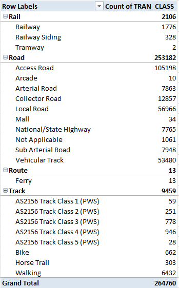
- LIST_Roads.PNG (18.14 KiB) Viewed 24087 times
Re: LIST Open Data - QGIS Style Sheets
Posted: Tue 19 Jun, 2018 6:55 pm
by conclavia
Thanks, Phil! That sounds great... my wife and I have both signed up and will definitely be coming along to the session. We've just moved to Cambridge so it wouldn't be much of a stretch to say you're just down the road!
I ran into some trouble with labels disappearing when I tried to get them to curve with the lines. I'm still working my way through the tutorial, so hopefully the answer might become clear once I understand a bit more of what I'm actually doing

At the moment I've got a bit side-tracked writing a script to download all the datasets that I want and get them all nicely organised with the right styles following your tip about naming them the same as the shp files.
That table is very helpful! I was definitely missing a few road types and had completely left out rail and ferries. Out of curiosity, what do you find the best way to get the attribute data into Excel so you can work with it? I've been using a tool called geopandas to explore it but that looks a lot like a pivot table to me
Cheers,
Wayne.
Re: LIST Open Data - QGIS Style Sheets
Posted: Wed 20 Jun, 2018 10:11 am
by tastrax
Easiest way to get the attributes into excel is either select all the attribute table, copy and then paste into excel (it even picks up field names) or Right Click the layer name and save as CSV. After that, pivot tables are easy!
Re: LIST Open Data - QGIS Style Sheets
Posted: Thu 12 Jul, 2018 11:01 am
by LeftRightShoot
Thank you so much for this!
Re: LIST Open Data - QGIS Style Sheets
Posted: Thu 12 Jul, 2018 4:07 pm
by tastrax
No worries. One thing that Wayne has found is that the transport layer is trimmed at the shoreline/coast so there are bridges missing between local government areas. That means the Tasman Bridge and Risdon Bridge are both missing even if you have Clarence, Hobart and Glenorchy transport layers! I think he has reported this to LIST so hopefully they will fix the issue with the most recent downloads.
Re: LIST Open Data - QGIS Style Sheets
Posted: Thu 19 Dec, 2019 9:13 pm
by tastrax
I have some updated notes on using LIST data in QGIS 3.X for anyone that is interested. This has all the new URL's for some of the services after they changed to https/MapServer in the URL's
Re: LIST Open Data - QGIS Style Sheets
Posted: Sat 08 Feb, 2020 8:44 am
by neilmny
Hi Phil,
Are you using QGIS 3.10 these days.
I seem to use 3.10.2 rather than 3.4.15 but have both installed. (Still have 2.18.28 installed as well????)
There was a couple of glitches in 3.4.14 and earlier that might have been fixed in 3.4.15 but 3.10 versions didn't have the problem.
One was bringing a searched or selected element to the top when viewing the attributes table by clicking the "Move selection to top" button.
In 3.4.14 and earlier it just didn't seem to work or perhaps how the selection was made was critical. In 3.10 it has always worked.
Pondering uninstalling 3.4....have I missed something?
regards, Neil.