Game: Where-is-it (Aussie)
Only administrators may post new topics to this forum. Registered users can post replies.
Re: Game: Where-is-it (Aussie)
![]() by johnw » Mon 27 Feb, 2023 1:55 pm
by johnw » Mon 27 Feb, 2023 1:55 pm
In Nature's keeping they are safe, but through the agency of man destruction is making rapid progress - John Muir c1912
-
johnw - Lagarostrobos franklinii

- Posts: 9616
- Joined: Wed 23 Jan, 2008 11:59 am
- Location: Macarthur Region - SW Sydney
- Region: New South Wales
- Gender: Male
Re: Game: Where-is-it (Aussie)
![]() by GBW » Mon 27 Feb, 2023 3:56 pm
by GBW » Mon 27 Feb, 2023 3:56 pm
-
GBW - Athrotaxis selaginoides

- Posts: 1175
- Joined: Fri 02 May, 2014 9:03 am
- Location: Melbourne
- Region: Victoria
- Gender: Male
Re: Game: Where-is-it (Aussie)
![]() by johnw » Mon 27 Feb, 2023 4:10 pm
by johnw » Mon 27 Feb, 2023 4:10 pm
In Nature's keeping they are safe, but through the agency of man destruction is making rapid progress - John Muir c1912
-
johnw - Lagarostrobos franklinii
- Posts: 9616
- Joined: Wed 23 Jan, 2008 11:59 am
- Location: Macarthur Region - SW Sydney
- Region: New South Wales
- Gender: Male
Re: Game: Where-is-it (Aussie)
![]() by GBW » Mon 27 Feb, 2023 4:27 pm
by GBW » Mon 27 Feb, 2023 4:27 pm
-
GBW - Athrotaxis selaginoides
- Posts: 1175
- Joined: Fri 02 May, 2014 9:03 am
- Location: Melbourne
- Region: Victoria
- Gender: Male
Re: Game: Where-is-it (Aussie)
![]() by johnw » Tue 28 Feb, 2023 11:12 am
by johnw » Tue 28 Feb, 2023 11:12 am
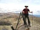
GBW wrote:What are these poles for? There were a few along this section and near Smiths Lookout.
My first thought when I saw the photo was snow poles but the number and position looks odd.
They are close to an old vehicle trail though, maybe some very deep drifts occur only in certain spots?
NSW:
- On Kangaroo Ridge, Kosciuszko NP via Charlotte Pass NSW
In Nature's keeping they are safe, but through the agency of man destruction is making rapid progress - John Muir c1912
-
johnw - Lagarostrobos franklinii
- Posts: 9616
- Joined: Wed 23 Jan, 2008 11:59 am
- Location: Macarthur Region - SW Sydney
- Region: New South Wales
- Gender: Male
-

crollsurf - Lagarostrobos franklinii
- Posts: 2315
- Joined: Tue 07 Mar, 2017 10:07 am
- Location: Sydney
- Region: New South Wales
- Gender: Male
Re: Game: Where-is-it (Aussie)
![]() by johnw » Tue 28 Feb, 2023 2:43 pm
by johnw » Tue 28 Feb, 2023 2:43 pm
icefest wrote:This is a flow measuring station, and part of the infrastructure used to convert river height into flow.
The hut is used to store the machinery and electronics.
The flying fox is used to put flow sensors into the river at set points to try and estimate the actual flow per second for that river level.
The table of flow rate vs river level is used to interpolate the flow for other river levels.
Thanks for this icefest, that all makes sense. Guthega Dam is just downstream a couple of kms.
I only stumbled onto the measuring station because I was somewhat off course.
crollsurf wrote:Overlooking Betts Creek?
Not Betts Creek but you're not too far away. Just need the landform name.
In Nature's keeping they are safe, but through the agency of man destruction is making rapid progress - John Muir c1912
-
johnw - Lagarostrobos franklinii
- Posts: 9616
- Joined: Wed 23 Jan, 2008 11:59 am
- Location: Macarthur Region - SW Sydney
- Region: New South Wales
- Gender: Male
-

eggs - Lagarostrobos franklinii
- Posts: 10778
- Joined: Fri 23 May, 2008 2:58 pm
- Location: Para Vista, South Australia
- Region: South Australia
Re: Game: Where-is-it (Aussie)
![]() by johnw » Tue 28 Feb, 2023 7:06 pm
by johnw » Tue 28 Feb, 2023 7:06 pm
eggs wrote:Maybe Kangaroo Ridge?
Yes eggs. I've been back there a few times. Very underrated area for walking IMHO. Go up Mt Stillwell and head wherever you like from there.
In Nature's keeping they are safe, but through the agency of man destruction is making rapid progress - John Muir c1912
-
johnw - Lagarostrobos franklinii
- Posts: 9616
- Joined: Wed 23 Jan, 2008 11:59 am
- Location: Macarthur Region - SW Sydney
- Region: New South Wales
- Gender: Male
Re: Game: Where-is-it (Aussie)
![]() by johnw » Fri 03 Mar, 2023 9:27 am
by johnw » Fri 03 Mar, 2023 9:27 am
In Nature's keeping they are safe, but through the agency of man destruction is making rapid progress - John Muir c1912
-
johnw - Lagarostrobos franklinii
- Posts: 9616
- Joined: Wed 23 Jan, 2008 11:59 am
- Location: Macarthur Region - SW Sydney
- Region: New South Wales
- Gender: Male
Re: Game: Where-is-it (Aussie)
![]() by eggs » Fri 03 Mar, 2023 11:29 am
by eggs » Fri 03 Mar, 2023 11:29 am
Yes John - got to Stilwell but would love to have explored further.
This is from a now defunct route in the NT.
-
eggs - Lagarostrobos franklinii
- Posts: 10778
- Joined: Fri 23 May, 2008 2:58 pm
- Location: Para Vista, South Australia
- Region: South Australia
Re: Game: Where-is-it (Aussie)
![]() by eggs » Sun 05 Mar, 2023 5:04 pm
by eggs » Sun 05 Mar, 2023 5:04 pm
-
eggs - Lagarostrobos franklinii
- Posts: 10778
- Joined: Fri 23 May, 2008 2:58 pm
- Location: Para Vista, South Australia
- Region: South Australia
Re: Game: Where-is-it (Aussie)
![]() by north-north-west » Sun 05 Mar, 2023 6:26 pm
by north-north-west » Sun 05 Mar, 2023 6:26 pm
-

north-north-west - Lagarostrobos franklinii
- Posts: 15412
- Joined: Thu 14 May, 2009 7:36 pm
- Location: The Asylum
- ASSOCIATED ORGANISATIONS: Social Misfits Anonymous
- Region: Tasmania
Re: Game: Where-is-it (Aussie)
![]() by eggs » Sun 05 Mar, 2023 7:32 pm
by eggs » Sun 05 Mar, 2023 7:32 pm
-
eggs - Lagarostrobos franklinii
- Posts: 10778
- Joined: Fri 23 May, 2008 2:58 pm
- Location: Para Vista, South Australia
- Region: South Australia
Re: Game: Where-is-it (Aussie)
![]() by north-north-west » Mon 06 Mar, 2023 10:03 am
by north-north-west » Mon 06 Mar, 2023 10:03 am
Staying in the NT. Fill in the missing names: I'm walking from ... to ... on a track.
- Attachments
-
-
north-north-west - Lagarostrobos franklinii
- Posts: 15412
- Joined: Thu 14 May, 2009 7:36 pm
- Location: The Asylum
- ASSOCIATED ORGANISATIONS: Social Misfits Anonymous
- Region: Tasmania
Re: Game: Where-is-it (Aussie)
![]() by north-north-west » Thu 09 Mar, 2023 6:47 am
by north-north-west » Thu 09 Mar, 2023 6:47 am
-
north-north-west - Lagarostrobos franklinii
- Posts: 15412
- Joined: Thu 14 May, 2009 7:36 pm
- Location: The Asylum
- ASSOCIATED ORGANISATIONS: Social Misfits Anonymous
- Region: Tasmania
Re: Game: Where-is-it (Aussie)
![]() by eggs » Thu 09 Mar, 2023 9:24 am
by eggs » Thu 09 Mar, 2023 9:24 am
May have been coming from Ormiston Gorge?
It depends whether you were going east of west.
-
eggs - Lagarostrobos franklinii
- Posts: 10778
- Joined: Fri 23 May, 2008 2:58 pm
- Location: Para Vista, South Australia
- Region: South Australia
Re: Game: Where-is-it (Aussie)
![]() by north-north-west » Thu 09 Mar, 2023 11:58 am
by north-north-west » Thu 09 Mar, 2023 11:58 am
-
north-north-west - Lagarostrobos franklinii
- Posts: 15412
- Joined: Thu 14 May, 2009 7:36 pm
- Location: The Asylum
- ASSOCIATED ORGANISATIONS: Social Misfits Anonymous
- Region: Tasmania
Re: Game: Where-is-it (Aussie)
![]() by eggs » Thu 09 Mar, 2023 2:40 pm
by eggs » Thu 09 Mar, 2023 2:40 pm
This is in SA.
-
eggs - Lagarostrobos franklinii
- Posts: 10778
- Joined: Fri 23 May, 2008 2:58 pm
- Location: Para Vista, South Australia
- Region: South Australia
Re: Game: Where-is-it (Aussie)
![]() by johnw » Fri 10 Mar, 2023 2:34 pm
by johnw » Fri 10 Mar, 2023 2:34 pm
In Nature's keeping they are safe, but through the agency of man destruction is making rapid progress - John Muir c1912
-
johnw - Lagarostrobos franklinii
- Posts: 9616
- Joined: Wed 23 Jan, 2008 11:59 am
- Location: Macarthur Region - SW Sydney
- Region: New South Wales
- Gender: Male
Re: Game: Where-is-it (Aussie)
![]() by eggs » Fri 10 Mar, 2023 7:06 pm
by eggs » Fri 10 Mar, 2023 7:06 pm
Over to you.
-
eggs - Lagarostrobos franklinii
- Posts: 10778
- Joined: Fri 23 May, 2008 2:58 pm
- Location: Para Vista, South Australia
- Region: South Australia
Re: Game: Where-is-it (Aussie)
![]() by johnw » Fri 10 Mar, 2023 8:08 pm
by johnw » Fri 10 Mar, 2023 8:08 pm
eggs wrote:Deep Creek was all I needed and the climb up is in view, but you cannot see the cove from Tapanappa.
Over to you.
I wish people on the internet would label their photos correctly. I found several almost exact matches claiming to be from Tapanappa LO
NSW:
- Looking towards Mt Northcote from near the northern end of Lake Albina, Kosciuszko NP via Charlotte Pass NSW
In Nature's keeping they are safe, but through the agency of man destruction is making rapid progress - John Muir c1912
-
johnw - Lagarostrobos franklinii
- Posts: 9616
- Joined: Wed 23 Jan, 2008 11:59 am
- Location: Macarthur Region - SW Sydney
- Region: New South Wales
- Gender: Male
Re: Game: Where-is-it (Aussie)
![]() by GBW » Fri 10 Mar, 2023 9:18 pm
by GBW » Fri 10 Mar, 2023 9:18 pm
-
GBW - Athrotaxis selaginoides
- Posts: 1175
- Joined: Fri 02 May, 2014 9:03 am
- Location: Melbourne
- Region: Victoria
- Gender: Male
Re: Game: Where-is-it (Aussie)
![]() by johnw » Sat 11 Mar, 2023 10:14 am
by johnw » Sat 11 Mar, 2023 10:14 am
GBW wrote:Mt Northcote from Albina Lake?
Spot on GBW, all yours.
In Nature's keeping they are safe, but through the agency of man destruction is making rapid progress - John Muir c1912
-
johnw - Lagarostrobos franklinii
- Posts: 9616
- Joined: Wed 23 Jan, 2008 11:59 am
- Location: Macarthur Region - SW Sydney
- Region: New South Wales
- Gender: Male
Re: Game: Where-is-it (Aussie)
![]() by GBW » Sun 12 Mar, 2023 3:59 pm
by GBW » Sun 12 Mar, 2023 3:59 pm
-
GBW - Athrotaxis selaginoides
- Posts: 1175
- Joined: Fri 02 May, 2014 9:03 am
- Location: Melbourne
- Region: Victoria
- Gender: Male
Re: Game: Where-is-it (Aussie)
![]() by Walk_fat boy_walk » Sun 12 Mar, 2023 8:36 pm
by Walk_fat boy_walk » Sun 12 Mar, 2023 8:36 pm
Sent from my SM-S906E using Tapatalk
- Walk_fat boy_walk
- Lagarostrobos franklinii
- Posts: 2312
- Joined: Sat 21 Nov, 2009 6:59 am
- Gender: Male
Re: Game: Where-is-it (Aussie)
![]() by GBW » Mon 13 Mar, 2023 8:17 am
by GBW » Mon 13 Mar, 2023 8:17 am
-
GBW - Athrotaxis selaginoides
- Posts: 1175
- Joined: Fri 02 May, 2014 9:03 am
- Location: Melbourne
- Region: Victoria
- Gender: Male
Re: Game: Where-is-it (Aussie)
![]() by Walk_fat boy_walk » Mon 13 Mar, 2023 3:56 pm
by Walk_fat boy_walk » Mon 13 Mar, 2023 3:56 pm
Sent from my SM-S906E using Tapatalk
- Walk_fat boy_walk
- Lagarostrobos franklinii
- Posts: 2312
- Joined: Sat 21 Nov, 2009 6:59 am
- Gender: Male
Re: Game: Where-is-it (Aussie)
![]() by ribuck » Mon 13 Mar, 2023 7:21 pm
by ribuck » Mon 13 Mar, 2023 7:21 pm
-

ribuck - Athrotaxis selaginoides
- Posts: 1893
- Joined: Wed 15 May, 2013 3:47 am
- Region: Other Country
- Gender: Male
Re: Game: Where-is-it (Aussie)
![]() by eggs » Mon 13 Mar, 2023 10:11 pm
by eggs » Mon 13 Mar, 2023 10:11 pm
-
eggs - Lagarostrobos franklinii
- Posts: 10778
- Joined: Fri 23 May, 2008 2:58 pm
- Location: Para Vista, South Australia
- Region: South Australia
Return to Games and Competitions
Who is online
Users browsing this forum: Google [Bot] and 105 guests