NSW & ACT specific bushwalking discussion.

Forum rules

NSW & ACT specific bushwalking discussion. Please avoid publishing details of access to sensitive areas with no tracks.
Post a reply

1857 grose river Bridale track

Mon 10 Mar, 2025 8:37 pm

some of you might have seen articles regard a very early survey of the Grose river...
"..Following a preliminary survey in 1857, a group of army engineers were given the 6 week assignment of constructing a bridle track up the Grose River Gorge, from the Nepean River near Yarramundi.."
"..Where the track ran beside the river, it has long since been washed away. But in many places, it climbed above the flood level. Here, the hand-made stone embankments are still in place.
A map believed to date from the 1930's (Department of Lands) shows a "trail, negotiable route or doubtful track" from Yarramundi to Blue Gum Forest.."

now my question is.. has anyone on this forum actually walked along the lower sections of the Grose river and spotted any relics of this path that was built?

apparently the project was cancelled after 18 months of effort building it after HQ started asking questions as to where and what the 50 person strong group was doing... :D

Re: 1857 grose river Bridale track

Tue 11 Mar, 2025 1:01 pm

Yes is is still visible in quite a few places lower down and is known as the Engineers Track. There is a publication on it which I have at home somewhere.

K

Re: 1857 grose river Bridale track

Tue 11 Mar, 2025 1:41 pm

Plenty of stone work on the track is visible and in good condition. There are some paint markings on a rock face on the southern side of the river, west of Burralow creek. These markings look very old style. The engineers were taken from Tas (Port Albert ?) as they had northing to do there and put on the bridle track. The plan was to eventually put a railway along it. I can't recall who commissioned the work but it is in a book here somewhere. Whomever it was left the engineers to their own devices and when the track was complete (thinking it took a lot longer than 6 weeks) it was inspected and there was no way a rail system could go there. It was a huge waste of money.

The valley was surveyed again mid last century to see if it was suitable for a dam but that was knocked on the head due to significant resistance and protest. I actually had dinner with the bloke who did that survey. We were at the Barrington guest house and he was the random dinner partner.

Re: 1857 grose river Bridale track

Tue 11 Mar, 2025 8:22 pm

Currently planning a trip with a mate.
I have done bits and pieces in several sections in the last few years.
"Doing bits and pieces" = scrambling about in thick scrub and lawyer vine looking for the damn thing. I have found clear parts/evidence of the track but (without having comparative experience from the past) my feeling is its a lot more difficult than it used to be.
Anyone i've talked to who's done it recently says it's *&%$#!. But i'm keen to give it a go. I know various exit points if its getting painful... and some of my sorties have been pretty painful so i know what i'm in for.

Edit: have I seen remnants of the track along the lower part - yes, I think so. Largely stone work propping up a bit of a pad. I couldn't tell you exactly where though (although above burralow creek sounds right). In the upper part, the same - there's a nice couple of bits below the darling causeway and under Ikara head that are quite obvious (and then suddenly, absolutely nothing at all and the worst lawyer vine I've encountered more or less). Then the whole section from Burra Korain -> Blue Gum Forest follows where the track was, as well, and is is common use, i.e., it is still the track; you can still see remnants, perhaps, but, because it's been in use for a long tim, how much is actually what the engineers did and how much has been fixed/reconstructed/looped over etc etc is anyone's guess I suppose. In the middle section, the bits and pieces I've looked at, under faulckonbridge and linden, yeah, not much.

Edit 2: had a look through some old pics. The only ones I could find was the section under Ikara ridge up near the top:

Image

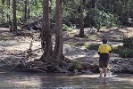
And here's me trying to recreate a photo taken on the track in the 1870s with Ikara head in the background (no top hat and tails for me I'm afraid)

Image

Image

Couple of things worth noting - there's a famous story of a couple of Tiger Walkers from the Sydney Bushwalkers running it from Blue Gum -> Yarramundi in 20 hours - I think Max Gentle and the other being Dot English/Butler who did it in her classic barefoot style. Can't talk about the track/route without mentioning that.

Also, as alluded to already, it was never going to work as a route for the railway - I seem to remember that the fella(s) in charge were well aware of that after not very much time at all, but had their contract for the bridal trail and pushed on none-the-less.it was completed though, all the way to the Hartley Vale siding on the darling causeway.

Re: 1857 grose river Bridale track

Sun 20 Apr, 2025 9:06 pm

that sounds promising... great pictures also!

Re: 1857 grose river Bridale track

Sun 20 Apr, 2025 9:38 pm

actually i suspect the engineers track is a different thing as the track im thinking of was explored and built much earlier and started where the Grose enters the Nepean in the 1850-1860's
ive walked the engineers track from "the Causeway" around under Ikara head and up to the Victoria falls rd..
lol.. i lost the trail of yellow spray paint blobs multiple times around the base of ikara and that was in 08-01-2017!
wow.. I had to look it up.. :)
bell station to Mt Victoria station the hard way in a day!!

Re: 1857 grose river Bridale track

Mon 21 Apr, 2025 7:26 am

dnaylor wrote:actually i suspect the engineers track is a different thing as the track im thinking of was explored and built much earlier and started where the Grose enters the Nepean in the 1850-1860's
ive walked the engineers track from "the Causeway" around under Ikara head and up to the Victoria falls rd..
lol.. i lost the trail of yellow spray paint blobs multiple times around the base of ikara and that was in 08-01-2017!
wow.. I had to look it up.. :)
bell station to Mt Victoria station the hard way in a day!!


The engineers track was started in 1858 after a preliminary survey the year before. I have spent a considerable amount of time on the Grose and not seen any evidence of an alternate track. The area around the confluence of the Grose and Nepean/Hawkesbury has been significantly developed and there are no traces of any old track there now.
Post a reply