Not sure if it's been looked at but the old SBW magazines are always worth checking
Search of all for the term
https://ozultimate.com/sbw/wiki/start?d ... =syncarpia
Here are three which might be of interest
https://ozultimate.com/sbw/wiki/193807?s[]=syncarpia
https://ozultimate.com/sbw/wiki/194112?s[]=syncarpia
https://ozultimate.com/sbw/wiki/195306?s[]=syncarpia
Syncarpia camp site on Govett's Creek, Blue Mountains
Forum rules
NSW & ACT specific bushwalking discussion. Please avoid publishing details of access to sensitive areas with no tracks.
NSW & ACT specific bushwalking discussion. Please avoid publishing details of access to sensitive areas with no tracks.
48 posts
• Page 2 of 2 • 1, 2
Re: Syncarpia camp site on Govett's Creek, Blue Mountains
![]() by Allchin09 » Fri 10 May, 2024 3:55 pm
by Allchin09 » Fri 10 May, 2024 3:55 pm
Tackling the unknown and the awesome one adventure at a time!
Try www.bushwalkingmaps.com
Try www.bushwalkingmaps.com
- Allchin09
- Phyllocladus aspleniifolius

- Posts: 715
- Joined: Fri 27 Apr, 2012 3:24 pm
- ASSOCIATED ORGANISATIONS: Sydney Bush Walkers
- Region: New South Wales
- Gender: Male
Re: Syncarpia camp site on Govett's Creek, Blue Mountains
![]() by Allchin09 » Fri 10 May, 2024 4:31 pm
by Allchin09 » Fri 10 May, 2024 4:31 pm
I also just checked a Dunphy publication relating to Central Blue Mountains Place-Names.
It was prepared for the Place-names Comittee of the Blue Mountains National Park Trust.
Dated 1965
Section 4 name #74
Not overly helpful in confirming the location
It was prepared for the Place-names Comittee of the Blue Mountains National Park Trust.
Dated 1965
Section 4 name #74
Syncarpia Camp
Bushwalkers' and rock-climbers' camping place on upper part of Govetts Leap Creek, between Arethusa Falls and Junction Rock, since 1933 (Syncarpia = turpentine tree)
Not overly helpful in confirming the location
Tackling the unknown and the awesome one adventure at a time!
Try www.bushwalkingmaps.com
Try www.bushwalkingmaps.com
- Allchin09
- Phyllocladus aspleniifolius
- Posts: 715
- Joined: Fri 27 Apr, 2012 3:24 pm
- ASSOCIATED ORGANISATIONS: Sydney Bush Walkers
- Region: New South Wales
- Gender: Male
Re: Syncarpia camp site on Govett's Creek, Blue Mountains
![]() by tom_brennan » Fri 10 May, 2024 5:35 pm
by tom_brennan » Fri 10 May, 2024 5:35 pm
Allchin09 wrote:Not sure if it's been looked at but the old SBW magazines are always worth checking
Note that the new URL for SBW magazines (and other history) is https://history.sbw.org.au
I did search them, but I was a bit surprised how few references there were, and that none of the references were very specific.
I imagine there must be some other old clubs with publications that would give a pointer!
Bushwalking NSW - http://bushwalkingnsw.com
-
tom_brennan - Athrotaxis selaginoides

- Posts: 1428
- Joined: Wed 29 Sep, 2010 9:21 am
- Location: Sydney
- Region: New South Wales
- Gender: Male
Re: Syncarpia camp site on Govett's Creek, Blue Mountains
![]() by marron » Fri 10 May, 2024 5:51 pm
by marron » Fri 10 May, 2024 5:51 pm
Thanks Tom and Allchin.
I suspect any specific Syncarpia will be whatever the user of the name wants it to be... and that may have always been the case.
Wherever it is/was, there's some lovely turpentine in that nook
I suspect any specific Syncarpia will be whatever the user of the name wants it to be... and that may have always been the case.
Wherever it is/was, there's some lovely turpentine in that nook
-
marron - Atherosperma moschatum

- Posts: 77
- Joined: Sun 16 Jan, 2022 10:29 am
- Region: New South Wales
Re: Syncarpia camp site on Govett's Creek, Blue Mountains
![]() by marron » Sun 09 Jun, 2024 5:28 pm
by marron » Sun 09 Jun, 2024 5:28 pm
I know this is now way off Syncarpia discussion (although that Dunphy map puts Syncarpia up the creek... ) but I had a crack at getting to the junction of Katoomba and Govetts creeks today via the, er, directions supplied by the early 20th century tourist map which places Arethusa there*. I know those buggers were hardy but I doubt they got there that way unless they were happy to swim (I thought long and hard about it myself, and decided against it - probably about 200 metres short, hence the long think, but just wasn't worth it - I'll try coming down the creek from bruce's walk or something next time). I'll write up a bit of a report later maybe. But yep, still a mystery as to what they were identifying as Arethusa.
*i didn't notice above, but one of those tourist maps is from the "Dunphy collection" which probably explains where he got his info from for the 60s designation, even though by then Arethusa was clearly the name of the falls that drop into Govetts gorge at the end of the canyon.
*i didn't notice above, but one of those tourist maps is from the "Dunphy collection" which probably explains where he got his info from for the 60s designation, even though by then Arethusa was clearly the name of the falls that drop into Govetts gorge at the end of the canyon.
-
marron - Atherosperma moschatum
- Posts: 77
- Joined: Sun 16 Jan, 2022 10:29 am
- Region: New South Wales
Re: Syncarpia camp site on Govett's Creek, Blue Mountains
![]() by keithj » Mon 10 Jun, 2024 8:16 pm
by keithj » Mon 10 Jun, 2024 8:16 pm
I've explored the area.
Arethusa Canyon
In mid 90s I did Arethusa Canyon dropping into Katoomba Ck fairly high close to the power lines. We encountered much quicksand (I recall briefly losing a boot), various tyres, drums & sawn timber, before a looong trek down to the abseils. The canyon was first done in sixties?, so anything labelled Arethusa Falls in earlier maps could only be viewed from above, unless it was the final big drop. So I believe that Arethusa Falls is correctly labelled on the NSW Topo maps. This is close to where Alpheous Canyon joins from the South. Reversing the lower section of Alpheous is the usual exit from Arethusa Canyon - OSM has this exit route marked. It entails a couple of rope assisted climbs, some swims and a short grade 19(?) climb.
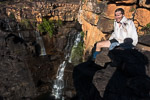
I did Arethusa Canyon again in 2023 - this is a photo from the top of the Falls. Alpheous is directly behind me.
Higher up Govetts Ck
I did some exploratories in 2020 similar to marrons recent trip. On one trip I found some old cairns ...
...and got to within 10m of creek level, well below the junction with Katoomba Creek via this route. There was a huge triangluar (tombstone?) shaped 10m high rock in the creek almost within reach of the edge.... might be worth a visit ?
The rock is visible on the NSW aerial shots.
Arethusa Canyon
In mid 90s I did Arethusa Canyon dropping into Katoomba Ck fairly high close to the power lines. We encountered much quicksand (I recall briefly losing a boot), various tyres, drums & sawn timber, before a looong trek down to the abseils. The canyon was first done in sixties?, so anything labelled Arethusa Falls in earlier maps could only be viewed from above, unless it was the final big drop. So I believe that Arethusa Falls is correctly labelled on the NSW Topo maps. This is close to where Alpheous Canyon joins from the South. Reversing the lower section of Alpheous is the usual exit from Arethusa Canyon - OSM has this exit route marked. It entails a couple of rope assisted climbs, some swims and a short grade 19(?) climb.
I did Arethusa Canyon again in 2023 - this is a photo from the top of the Falls. Alpheous is directly behind me.
Higher up Govetts Ck
I did some exploratories in 2020 similar to marrons recent trip. On one trip I found some old cairns ...
...and got to within 10m of creek level, well below the junction with Katoomba Creek via this route. There was a huge triangluar (tombstone?) shaped 10m high rock in the creek almost within reach of the edge.... might be worth a visit ?
The rock is visible on the NSW aerial shots.
- keithj
- Athrotaxis cupressoides

- Posts: 307
- Joined: Sun 01 Nov, 2015 7:27 pm
- Region: New South Wales
- Gender: Male
Re: Syncarpia camp site on Govett's Creek, Blue Mountains
![]() by marron » Tue 11 Jun, 2024 7:31 am
by marron » Tue 11 Jun, 2024 7:31 am
I saw the tombstone rock, took a photo which I will upload later. I think it would be doable, but a bit sketchy (and definitely sketchy on my own!)
Edit:
Here's the tombstone. As you can see, maybe, maybe. Also, on my first attempt at getting down I would have been up above it and I don't think I saw it from that angle - or perhaps there was another drop I was looking at first before I could even get there - sketchy, like I said.
https://i.ibb.co/b76T7hy/20240609-124001.jpg

https://i.ibb.co/Q9yBpZg/20240609-123927.jpg

It seems most people these days do Arethusa from much further down, access via Mt Hay Rd. I'd be surprised if people hadn't explored the upper reaches of Govetts/Katoomba much earlier than when the canyon proper was done in the 50s/60s (or 30s, if you count Butler and co scaling the falls and walking up as far as they could) - even if the maps are wrong about placing the final falls, people would have been walking the creek imo. Those maps saying "get down this way", even if they are innacurate, suggest people were heading down one way or another to me. Anyway.
If you came in at the power lines I suppose you don't recall if there were any impressive waterfalls along the way? Haha.
Edit:
Here's the tombstone. As you can see, maybe, maybe. Also, on my first attempt at getting down I would have been up above it and I don't think I saw it from that angle - or perhaps there was another drop I was looking at first before I could even get there - sketchy, like I said.
https://i.ibb.co/b76T7hy/20240609-124001.jpg
https://i.ibb.co/Q9yBpZg/20240609-123927.jpg
It seems most people these days do Arethusa from much further down, access via Mt Hay Rd. I'd be surprised if people hadn't explored the upper reaches of Govetts/Katoomba much earlier than when the canyon proper was done in the 50s/60s (or 30s, if you count Butler and co scaling the falls and walking up as far as they could) - even if the maps are wrong about placing the final falls, people would have been walking the creek imo. Those maps saying "get down this way", even if they are innacurate, suggest people were heading down one way or another to me. Anyway.
If you came in at the power lines I suppose you don't recall if there were any impressive waterfalls along the way? Haha.
-
marron - Atherosperma moschatum
- Posts: 77
- Joined: Sun 16 Jan, 2022 10:29 am
- Region: New South Wales
Re: Syncarpia camp site on Govett's Creek, Blue Mountains
![]() by bushwalkindudeman » Tue 11 Jun, 2024 8:22 pm
by bushwalkindudeman » Tue 11 Jun, 2024 8:22 pm
Hello Marron, Keith, I have enjoyed reading about you trying to piece together this puzzle so thought i would join in with some info..
I know this catchment well, both Govetts and Katoomba Creek down to the canyon.. you will be disappointed to hear there is no waterfall at the junction..
There is access down the obvious spur via a well defined walking track. Once you reach the cliffline and the track runs out, there is a bit of a small scramble down to the East which isn't super obvious immediately, before it follows a rough track steeply to the creek. You prob pop out about 40m upstream of the Junction in the Katoomba Creek arm.
As for the tombstone rock, i had sussed this out as a way in/out, but i think a lack of hand holds and overall steepness, and slipperiness kind of ruled it out as an option. From above maybe with ropes?
There is however a way up through the cliffs up the 2nd creek to the West of the rock, best viewed on Six maps. It is steep, muddy, goes under and over some rock slabs with an awkward scramble up the last section, but it does go.. would be difficult to find from above.
It is worth exploring this area above the creekline.. you may just stumble across something interesting as I'm certain Keith may have
Regards, Jeff
- bushwalkindudeman
- Nothofagus cunninghamii

- Posts: 3
- Joined: Mon 10 Jun, 2024 7:26 pm
- Region: New South Wales
Re: Syncarpia camp site on Govett's Creek, Blue Mountains
![]() by bushwalkindudeman » Tue 11 Jun, 2024 8:36 pm
by bushwalkindudeman » Tue 11 Jun, 2024 8:36 pm
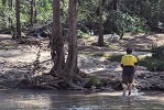
... Also, coming into the area, from Bruces walk on Katoomba Ck and heading downstream is a worthwhile trip with some nice scenery, looping back exiting via the spur i mentioned.. i believe a couple compulsory(or just easier)swims so best done in summer...
I do think the section you walked through is the prettiest section.. again best done in summer (you can swim/scramble up/down what you mentioned as twin falls)
I do think the section you walked through is the prettiest section.. again best done in summer (you can swim/scramble up/down what you mentioned as twin falls)
- bushwalkindudeman
- Nothofagus cunninghamii
- Posts: 3
- Joined: Mon 10 Jun, 2024 7:26 pm
- Region: New South Wales
Re: Syncarpia camp site on Govett's Creek, Blue Mountains
![]() by marron » Wed 12 Jun, 2024 11:03 am
by marron » Wed 12 Jun, 2024 11:03 am
Thanks Jeff!
Yes that was my assessment of the tombstone as well.
Interesting to note about the second creek, thanks for that too. I assume the spur with the walking track is the one between Katoomba/Govetts?
And now I 'm quite curious about this interesting thing - in the area above the tombstone yeah?
Anyway - I now wonder if the identification of the Arethusa Falls on those early tourist maps was actually simply a view of Arethusa Falls proper from Carne's Wall? Haven't been out that far myself.
Edit: oh, and yeah, it was deep near the falls, though they aren't very high; i opted to cross to the left and it was a relatively straightforward scramble up and over and around above them.
-
marron - Atherosperma moschatum
- Posts: 77
- Joined: Sun 16 Jan, 2022 10:29 am
- Region: New South Wales
Re: Syncarpia camp site on Govett's Creek, Blue Mountains
![]() by bushwalkindudeman » Wed 12 Jun, 2024 7:10 pm
by bushwalkindudeman » Wed 12 Jun, 2024 7:10 pm
Yes, the spur is the one heading North between the two creeks..
I wonder if the simple answer for the mis-marking on the map is exactly that, and it just gets compounded over time on other versions of maps, just repeating original error..?
There is the track to the fork between Govetts coming in from the South West and Alpheus canyon (Lerida Gorge) catchment coming from South East.. the Spur is heading the same direction.. maybe just plonked the 'Arethusa' in the wrong spot? Haha
Did you come down the creek to the east of the twin waterfall? Leads into a larger open area on the big U bend in the creek? Bit of a boulder hop up some large boulders and around to the spot where you took the photo? (Right side, heading upstream)?
- bushwalkindudeman
- Nothofagus cunninghamii
- Posts: 3
- Joined: Mon 10 Jun, 2024 7:26 pm
- Region: New South Wales
Re: Syncarpia camp site on Govett's Creek, Blue Mountains
![]() by marron » Wed 12 Jun, 2024 8:03 pm
by marron » Wed 12 Jun, 2024 8:03 pm
Good theory, makes a bit of sense.
Yes, i came down east (downstream) of the twin falls, into a bit of an amphitheatre with a creek flowing south into Govetts at that point and some sheer walls on the opposite side of Govetts itself. I didn't come down the creek itself, my approach was more like:

(leaving out some exploratory attempts to get down to the west etc)
Some big boulders around, I actually climbed up the bank a little to get around them rather than rock hop over, fairly easy to get to that spot with the little falls.
Yes, i came down east (downstream) of the twin falls, into a bit of an amphitheatre with a creek flowing south into Govetts at that point and some sheer walls on the opposite side of Govetts itself. I didn't come down the creek itself, my approach was more like:
(leaving out some exploratory attempts to get down to the west etc)
Some big boulders around, I actually climbed up the bank a little to get around them rather than rock hop over, fairly easy to get to that spot with the little falls.
-
marron - Atherosperma moschatum
- Posts: 77
- Joined: Sun 16 Jan, 2022 10:29 am
- Region: New South Wales
Re: Syncarpia camp site on Govett's Creek, Blue Mountains
![]() by marron » Wed 12 Jun, 2024 8:10 pm
by marron » Wed 12 Jun, 2024 8:10 pm
Also, just for interests sake, an article from 1931 with some interesting details about the falls, convicts, a lost bushwalker, lerida gorge....
https://trove.nla.gov.au/newspaper/article/159794272
https://trove.nla.gov.au/newspaper/article/159794272
-
marron - Atherosperma moschatum
- Posts: 77
- Joined: Sun 16 Jan, 2022 10:29 am
- Region: New South Wales
Re: Syncarpia camp site on Govett's Creek, Blue Mountains
![]() by johnw » Fri 14 Jun, 2024 12:04 pm
by johnw » Fri 14 Jun, 2024 12:04 pm
Test post - Recent posts by keithj not displaying in this topic.
John W
In Nature's keeping they are safe, but through the agency of man destruction is making rapid progress - John Muir c1912
In Nature's keeping they are safe, but through the agency of man destruction is making rapid progress - John Muir c1912
-
johnw - Lagarostrobos franklinii

- Posts: 9684
- Joined: Wed 23 Jan, 2008 11:59 am
- Location: Macarthur Region - SW Sydney
- Region: New South Wales
- Gender: Male
Re: Syncarpia camp site on Govett's Creek, Blue Mountains
![]() by keithj » Fri 14 Jun, 2024 1:40 pm
by keithj » Fri 14 Jun, 2024 1:40 pm
I can neither confirm nor denymarron wrote:And now I 'm quite curious about this interesting thing - in the area above the tombstone yeah?
Anyway - I now wonder if the identification of the Arethusa Falls on those early tourist maps was actually simply a view of Arethusa Falls proper from Carne's Wall? Haven't been out that far myself.
There have been people & cattle in the valley long before the first tourist maps. If I'd been a drover, I would have explored up to the creek to Arethusa Falls, especially as it is a valley that is hidden round the corner. All the other routes into the Grose are hard for cattle. They would probably have been the first to see it as it would be hard to spot from anywhere on the escarpment above unless you were right on the edge. Don't know who named it though or when.
I would agree - a tourist map printer is unlikely to be a cartographer with much care for accuracy.bushwalkindudeman wrote:maybe just plonked the 'Arethusa' in the wrong spot? Haha
Pretty sure there weren't. It was a loong day getting past the occasional quicksand. So you could probably reverse it (in summer) starting at your recent entry point. I recall a small jump that saw me waist deep in the sand - we went carefully after that.marron wrote:If you came in at the power lines I suppose you don't recall if there were any impressive waterfalls along the way? Haha.
You could get to the top of Arethusa Falls by following the track marked on OSM (take a few short ropes) and explore up to the last abseil.
And the top of the tombstone was hard to get to from above. No footholds near the edge ... just loose dirt & no reliable vegetation.
- keithj
- Athrotaxis cupressoides
- Posts: 307
- Joined: Sun 01 Nov, 2015 7:27 pm
- Region: New South Wales
- Gender: Male
Re: Syncarpia camp site on Govett's Creek, Blue Mountains
![]() by marron » Fri 14 Jun, 2024 4:18 pm
by marron » Fri 14 Jun, 2024 4:18 pm
Thanks Keith!
Eric Lowe named Vida/Lerida but Arethusa is named in the 1890s at least, so yeah, who knows.
Eric Lowe named Vida/Lerida but Arethusa is named in the 1890s at least, so yeah, who knows.
-
marron - Atherosperma moschatum
- Posts: 77
- Joined: Sun 16 Jan, 2022 10:29 am
- Region: New South Wales
Re: Syncarpia camp site on Govett's Creek, Blue Mountains
![]() by tom_brennan » Sun 16 Jun, 2024 7:13 pm
by tom_brennan » Sun 16 Jun, 2024 7:13 pm
keithj wrote:The canyon was first done in sixties?
An SBW party descended the whole canyon in Oct 1938. Likely to be the first technical canyoning descent in Australia (I don't know about other parts of the world, but I imagine it would be fairly early on that scale)! See https://history.sbw.org.au/wiki/193812?s[]=arethusa#club_gossip
Bushwalking NSW - http://bushwalkingnsw.com
-
tom_brennan - Athrotaxis selaginoides
- Posts: 1428
- Joined: Wed 29 Sep, 2010 9:21 am
- Location: Sydney
- Region: New South Wales
- Gender: Male
Re: Syncarpia camp site on Govett's Creek, Blue Mountains
![]() by marron » Wed 26 Jun, 2024 5:34 pm
by marron » Wed 26 Jun, 2024 5:34 pm
A couple of great little tidbits about Syncarpia and Arethusa in this arcticle from the Katoomba Daily in 1932 thanks to my father who went looking for any info and turned it up (my emphasis in bold:
First one = where people were looking at Arethusa from in order to be able to name it/spot it.
Second one = pretty clear reference to Syncarpia, putting it quite near the junction of Greaves/Govetts. (edit: hmmm... right bank? is that right bank proper? if so, that's my site no. 2, I guess)
Third one = fairly authoritative description of the wrong spot.
Most questions more or less answered now, I feel - except, what the hell were people looking at from the Grand Canyon road from Medlow.
A HIKING FEAT
-----------------
LADIES BRAVE DANGERS TO
FOOT OF ARETHUSA FALLS
------------
MAJESTIC SIGHT
------------
In a recent issue we referred
to photographs taken of Are-
thusa Falls by Mr. A. Manning,
and stated they were the first
pictures of this famed beauty
spot that we had heard of. We
learn, however, that a party, on
New Year's Day, worked its way
up the gorges to the foot of
the falls, when some fine ama-
teur pictures were taken.
In view of the popularity of hik-
ing on the Mountains at the present
time, and the many references made
to the almost inaccessible Arethusa
Falls, the following article from
Chas. J. Shaw, of Leura will be
read with interest. He states:
"In your issue of the 21st I not-
iced a paragraph about Arethusa
Falls and I am enclosing a snap
taken at the foot on January 1st
of this year. We had several times
looked down on these falls — a
gorgeous view - from the height
of a spur off Mt. Hay track, and
hearing the roar of water coming up
from the depths, and determined to
get right to them. On last New
Years' Day our small party started
from Medlow down the Grand Can-
yon until we readied [b]a part where
the gorge opens out and a fair-
sized creek comes in on the right.
On the right bank of this new
creek, near the junction with the
Canyon creek, is a beautiful camp-
ing spot under tall trees. [/b]Here we
left our belongings and made our
way up the gully between towering
cliffs on both sides. For part of the
way you can follow the remains of
an old track, with stone steps here
and there, but later you have to
make your way as best you can and
the going is fairly rough. Probably
the best way is to make for the top
of the tallus and follow that until
you come within view of the Falls,
and then glissade down to the creek
level near the foot of the falls.
Of course, if you leave bits
of yourself behind in the pro-
cess, you must grin and con-
sider it part of the game.
Anyway, we there fairly ...
late, and I think ... two ladies who
formed half of the party can pos-
sibly be congratulated on being the
first of their sex to get there. Any
dissentient voices?
We got back to camp just as
dusk was falling, and the crumbs
that were left after our meal made
the ants weep with disappointment.
That night we slept under the
stars, seemingly a thousand miles
from civilisation. A thunderstorm
passed overhead and woke us up
with a few heavy drops, but, hav-
ing had its joke, went on its way.
I believe the name Arethusa is
from a Greek legend of a goddess
turned into a waterfall. Is that
right? Anyway, whoever named this
waterfall Arethusa had a nice fancy.
[b]Mr. F. Walford first told us that
these falls were not in the position
as marked on most maps.[/b] As a mat-
ter of fact, Leura, Minna Ha Ha,
and Katoomba Creeks all junction
in a large pool at that spot and
then flow on through a deepening
gully until they finally jump down
Arethusa Falls into the inlet of the
Grose Valley that we climbed up.
First one = where people were looking at Arethusa from in order to be able to name it/spot it.
Second one = pretty clear reference to Syncarpia, putting it quite near the junction of Greaves/Govetts. (edit: hmmm... right bank? is that right bank proper? if so, that's my site no. 2, I guess)
Third one = fairly authoritative description of the wrong spot.
Most questions more or less answered now, I feel - except, what the hell were people looking at from the Grand Canyon road from Medlow.
-
marron - Atherosperma moschatum
- Posts: 77
- Joined: Sun 16 Jan, 2022 10:29 am
- Region: New South Wales
48 posts
• Page 2 of 2 • 1, 2
Return to New South Wales & ACT
Who is online
Users browsing this forum: No registered users and 39 guests