Page 1 of 1
Mt Guouogang
Posted: Thu 22 Sep, 2016 4:55 pm
by bold
How do you pronounce mt guouogang
Re: Mt Guouogang
Posted: Thu 22 Sep, 2016 6:08 pm
by ribuck
Gue - oh - a - gang
The first syllable rhymes with "glue"
The emphasis is on the second syllable
Re: Mt Guouogang
Posted: Thu 22 Sep, 2016 6:15 pm
by ribuck
In Caro Ryan's three peaks video, 20 seconds in, she pronounces it "Goo wow gang":
https://www.youtube.com/watch?v=9_uSnyL7TeI
Re: Mt Guouogang
Posted: Thu 22 Sep, 2016 6:25 pm
by bold
Thanks
Re: Mt Guouogang
Posted: Thu 22 Sep, 2016 6:31 pm
by puredingo
But IS there a correct way to pronounce such names? For are these not just misheard interpretations by the European settlers on the Aboriginal language.
Re: Mt Guouogang
Posted: Fri 23 Sep, 2016 1:18 am
by ribuck
puredingo wrote:But IS there a correct way to pronounce such names?
The correct way is the way that is understood by other people. That is not always the same as the traditional or original pronounciation.
The Gangerang bushwalkers sketch map annotates the mountain "Ku-o-wo-gang", which I presume is meant to be a pronounciation guide.

- 20160922_161126.jpg (67.32 KiB) Viewed 16438 times
Re: Mt Guouogang
Posted: Fri 23 Sep, 2016 5:57 am
by puredingo
Yep, that's true. So I wonder how the K got turned into G over time?
Re: Mt Guouogang
Posted: Fri 23 Sep, 2016 6:08 am
by jonnosan
That sketch map seems to place 'Mt Guouogang' half way down a steep slope ? Bizarely the topo seems to also have two spots labelled as Mt Guouogang - the summit (where the Jenolan trig station is) and the same spot as the above map. Any ideas what's going on there?
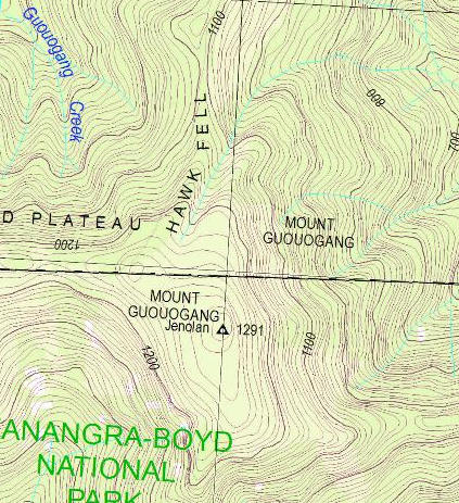
- Screen Shot 2016-09-23 at 6.04.42 AM.png (504.01 KiB) Viewed 16423 times
Re: Mt Guouogang
Posted: Fri 23 Sep, 2016 6:23 am
by ribuck
jonnosan wrote:That sketch map seems to place 'Mt Guouogang' half way down a steep slope ? Bizarely the topo seems to also have two spots labelled as Mt Guouogang - the summit (where the Jenolan trig station is) and the same spot as the above map. Any ideas what's going on there?
Heh, that's funny. Take a look at the sketch map and you'll see an arrow leading from the bottom of the "G" to the actual position. Don't be misled by the dot near the M; that's just a symbol to indicate that it's a government-approved name. Maybe the topo map copied the location from the sketch map and missed the (easy-to-miss) arrow.
Re: Mt Guouogang
Posted: Fri 23 Sep, 2016 12:45 pm
by kanangra
It is pronounced Gwow o gang.
K.
Re: Mt Guouogang
Posted: Fri 23 Sep, 2016 8:01 pm
by DaveNoble
kanangra wrote:It is pronounced Gwow o gang.
K.
I seem to recall Myles Dunphy pronouncing it that way.
Dave
Re: Mt Guouogang
Posted: Sat 24 Sep, 2016 8:23 am
by kjbeath
puredingo wrote:Yep, that's true. So I wonder how the K got turned into G over time?
I've been told by someone expert in Aboriginal languages that there is a sound in their languages which is somewhere between a G and a K, so it was recorded as either a G or K. This makes it difficult for someone from an English background to pronounce the words correctly without first learning how to make the sound. Apparently not easy.
This is similar to what happens in Japanese where there is a sound between an L and an R.
Re: Mt Guouogang
Posted: Mon 26 Sep, 2016 4:03 pm
by Allchin09
jonnosan wrote:That sketch map seems to place 'Mt Guouogang' half way down a steep slope ? Bizarely the topo seems to also have two spots labelled as Mt Guouogang - the summit (where the Jenolan trig station is) and the same spot as the above map. Any ideas what's going on there?
The attachment Screen Shot 2016-09-23 at 6.04.42 AM.png is no longer available
Where'd you get that screenshot from Jonno?
The latest version of the map looks like this.

- Capture23.PNG (1.05 MiB) Viewed 16237 times
Re: Mt Guouogang
Posted: Mon 26 Sep, 2016 4:06 pm
by Allchin09
kjbeath wrote:puredingo wrote:Yep, that's true. So I wonder how the K got turned into G over time?
I've been told by someone expert in Aboriginal languages that there is a sound in their languages which is somewhere between a G and a K, so it was recorded as either a G or K. This makes it difficult for someone from an English background to pronounce the words correctly without first learning how to make the sound. Apparently not easy.
This is similar to what happens in Japanese where there is a sound between an L and an R.
Re pronunciation, maybe Jim Barretts latest book, Gandanguurra: The language of the mountain people and beyond (see
http://shop.megalongbooks.com.au/bookwe ... 0994513502) may shed some light on the matter. I'll have a flick through it when it's next in my hand.
Re: Mt Guouogang
Posted: Mon 26 Sep, 2016 6:21 pm
by ribuck
puredingo wrote:Yep, that's true. So I wonder how the K got turned into G over time?
If you say it the sketch map way, Ku-o-wo-gang, the sound at the beginning is hardly distinguishable from a G.
As Allchin09 posted, the actual sound was probably between a G and a K.
We see the same thing in other nearby names. In written works from the 19th-century, the area south of modern-day Katoomba is spelled variously as Kedumba, Godoomba, Good-doom-bah, Katumba, and Katta-toon-bah. From
"Aboriginal Placenames: Naming and Re-naming the Australian Landscape, edited by Luise Anna Hercus, Harold James Koch" in which, unfortunately, I don't see a mention of Guouogang.
Re: Mt Guouogang
Posted: Mon 26 Sep, 2016 7:26 pm
by jonnosan
Allchin09 wrote:
Where'd you get that screenshot from Jonno?
From
http://topo.notto.be/I think that's pulling tiles from the NSW lands dept server as described here:
viewtopic.php?f=36&t=23130
Re: Mt Guouogang
Posted: Mon 26 Sep, 2016 8:25 pm
by Allchin09
I believe that topo.notto.be used to be pulling the tiles from the Spatial Services (new name for LPI) server, but stopped a while back when there were some server changes. It now displays an older cached copy.
maps.ozultimate.com should give you the latest version. For example look at the difference between the two around the base of Sublime Point
Re: Mt Guouogang
Posted: Tue 27 Sep, 2016 6:01 pm
by Allchin09
I had a look through Jim's book, but couldn't find a reference. I'm sure if you read through the whole thing and learnt the language from it, then you might have a better understanding of pronunciation.
The earliest map of the area that I have is a 'Map of the Colony of New South Wales' by Survey General Mitchell published 1834. The spelling appears to be Guowogang. It is interesting to note the nearby Konangaroo (what we now call Kanangra Creek) and Jenolan marked near the current day Mt O'Reilly. Colong is also spelt Collong, and what we know as Kanangra Walls was Thurat.