I'm finally getting out for my first walk since lockdown and am pondering including Mount Macdonald in my route. Just wondering if anyone knows if the route from the summit to Upper Jamieson Hut is still very overgrown? I've avoided it in the past when I've been with my partner but looks like I'll be solo this time so a bit more scrub is acceptable. However I'm not after anything too brutal!
Thanks
Mount Macdonald - Upper Jamieson Hut track condition
Forum rules
Victoria specific bushwalking discussion. Please avoid publishing details of access to sensitive areas with no tracks.
Victoria specific bushwalking discussion. Please avoid publishing details of access to sensitive areas with no tracks.
27 posts
• Page 1 of 1
Mount Macdonald - Upper Jamieson Hut track condition
![]() by Drew » Wed 17 Nov, 2021 8:39 am
by Drew » Wed 17 Nov, 2021 8:39 am
- Drew
- Phyllocladus aspleniifolius

- Posts: 788
- Joined: Fri 13 Jan, 2012 11:16 am
- Region: Victoria
- Gender: Male
Re: Mount Macdonald - Upper Jamieson Hut track condition
![]() by Hiking Exped » Wed 17 Nov, 2021 11:49 am
by Hiking Exped » Wed 17 Nov, 2021 11:49 am
Hi Drew,
Not made it up there this year as yet, but at the end of the Green Season last year it was not too bad. The higher part off the summit was fine, then as it steeply drops away over the rocky parts it was ok, but further down at the bottom of the main spur it was a bit overgrown in and around the saddles. There were some trees down, but it was not too much of a Commando course. I turned right along Low Saddle Road though as ascended up onto the Bluff. As such not sure what the final 1km to the hut is like as not done that for a few years.
Let me know how you go as it’s on my list again later this year.
- Hiking Exped
- Athrotaxis cupressoides

- Posts: 149
- Joined: Wed 13 Oct, 2021 8:05 am
- Region: Victoria
- Gender: Male
Re: Mount Macdonald - Upper Jamieson Hut track condition
![]() by Drew » Wed 17 Nov, 2021 2:44 pm
by Drew » Wed 17 Nov, 2021 2:44 pm
Thanks HIking Exped, that's promising. I might not decide on my route until tomorrow when I arrive, but sounds like it's worth considering. Depends on my appetite for road walking - hard to avoid large stretches of it if I want to include McDonald in a circuit walk.
- Drew
- Phyllocladus aspleniifolius
- Posts: 788
- Joined: Fri 13 Jan, 2012 11:16 am
- Region: Victoria
- Gender: Male
Re: Mount Macdonald - Upper Jamieson Hut track condition
![]() by Drew » Wed 17 Nov, 2021 6:01 pm
by Drew » Wed 17 Nov, 2021 6:01 pm
Although now that there's a severe weather warning for tomorrow I'm having second thoughts... Very wet soils and extreme winds sound like a recipe for trees falling on my tent!
- Drew
- Phyllocladus aspleniifolius
- Posts: 788
- Joined: Fri 13 Jan, 2012 11:16 am
- Region: Victoria
- Gender: Male
Re: Mount Macdonald - Upper Jamieson Hut track condition
![]() by paidal_chalne_vala » Wed 17 Nov, 2021 6:36 pm
by paidal_chalne_vala » Wed 17 Nov, 2021 6:36 pm
@hongomania on Ski dot com dot au tried to bush bash his way up the North face of Mt. McDonald in late 2020. The heat and the scrub drove him back. He is young , very fit and hardcore.
It is a hero hike/ scrub bash/ climb/ grovel
There is no track anymore. Even the Timbertop kids have given up on that route.
My friend and I went up to Mt. McDonald from the Nobs Track on the AAWT around the same time as @Hongomania did.
The heat drove us back from the true summit. The AAWT from the Nobs track to the summit area is quite overgrown indeed. :-0 .I have contacted BTAC about getting a working bee started up there and clearing that route on the AAWT.
- paidal_chalne_vala
- Lagarostrobos franklinii

- Posts: 2754
- Joined: Sun 22 Jan, 2012 10:30 pm
- ASSOCIATED ORGANISATIONS: VNPA.BTAC.Friends of Baw Baw.Mt.Bogong Club.
- Region: Victoria
- Gender: Male
Re: Mount Macdonald - Upper Jamieson Hut track condition
![]() by Drew » Thu 18 Nov, 2021 3:20 pm
by Drew » Thu 18 Nov, 2021 3:20 pm
Thanks PCV - rather different report to Hiking Exped's! Perhaps he nailed the route and hongomania got his line wrong?
Well, all academic for me for the time being. After seeing the nasty wind forecast I decided to be sensible and stay home today. I'm planning to go up tomorrow if the forecast looks alright, but won't have time for McDonald. Maybe just a well-worn Helicopter Spur - The Bluff circuit from 8 Mile Flat instead.
Well, all academic for me for the time being. After seeing the nasty wind forecast I decided to be sensible and stay home today. I'm planning to go up tomorrow if the forecast looks alright, but won't have time for McDonald. Maybe just a well-worn Helicopter Spur - The Bluff circuit from 8 Mile Flat instead.
- Drew
- Phyllocladus aspleniifolius
- Posts: 788
- Joined: Fri 13 Jan, 2012 11:16 am
- Region: Victoria
- Gender: Male
Re: Mount Macdonald - Upper Jamieson Hut track condition
![]() by Hiking Exped » Fri 19 Nov, 2021 4:35 pm
by Hiking Exped » Fri 19 Nov, 2021 4:35 pm
I’m certainly not mega fit, and use just a map and compass…hahahaha
As I said it was overgrown in parts and trees were down, but I could still work out the spur and use animal tracks a bit, It was a cool midweek hike in May and I did not have the heat to deal with. Like much of this area the tracks are very overgrown. Even some of the AAWT gets very overgrown. The Rangers and working bees do there best, but some tracks are just not used enough. At least no real blackberry problem here, unlike some others,
The forecast, yep that’s a downer.
Hope you get a trip in though.
I’ll be up around the Bluff midweek weather depending,
- Hiking Exped
- Athrotaxis cupressoides
- Posts: 149
- Joined: Wed 13 Oct, 2021 8:05 am
- Region: Victoria
- Gender: Male
Re: Mount Macdonald - Upper Jamieson Hut track condition
![]() by neilmny » Mon 22 Nov, 2021 11:38 am
by neilmny » Mon 22 Nov, 2021 11:38 am
Drew wrote:Thanks PCV - rather different report to Hiking Exped's! Perhaps he nailed the route and hongomania got his line wrong?
Well, all academic for me for the time being. After seeing the nasty wind forecast I decided to be sensible and stay home today. I'm planning to go up tomorrow if the forecast looks alright, but won't have time for McDonald. Maybe just a well-worn Helicopter Spur - The Bluff circuit from 8 Mile Flat instead.
How did the weather turn out Drew?
I'm seeing overstated risk being anounced by the BOM all the time. Used to be they just provided a weather forecast and some warnings (mostly sheep graziers) from time to time.
Seems these days every time the wind blows there is another mostly unnecessary warning. It's got to be a product of the ambulance chasers.
It used to be you went into the bush knowing it was entirely at your own risk and consequences.
A very sad situation. What will it be like for my grandsons, will adventure be going out to the supermarket?
Sorry for the rant but it does trouble me.
-
neilmny - Lagarostrobos franklinii
- Posts: 2576
- Joined: Fri 03 Aug, 2012 11:19 am
- Region: Victoria
- Gender: Male
Re: Mount Macdonald - Upper Jamieson Hut track condition
![]() by Drew » Mon 22 Nov, 2021 12:09 pm
by Drew » Mon 22 Nov, 2021 12:09 pm
How did the weather turn out Drew?
I'm seeing overstated risk being anounced by the BOM all the time. Used to be they just provided a weather forecast and some warnings (mostly sheep graziers) from time to time.
Seems these days every time the wind blows there is another mostly unnecessary warning. It's got to be a product of the ambulance chasers.
It used to be you went into the bush knowing it was entirely at your own risk and consequences.
A very sad situation. What will it be like for my grandsons, will adventure be going out to the supermarket?
Sorry for the rant but it does trouble me.
No worries Neil, you do make a fair point I think! I delayed until Friday to avoid the wind. So I have no idea whether the severe winds did eventuate on Thursday, but from Friday to Sunday the weather was pretty benign. It does seem that the weather forecasters are finding it particularly difficult lately. Maybe to do with volatile weather related to La Niña? Within a couple of days the forecast for Sunday changed from predictions of high amounts of rain and strong winds to sunny and light winds! Mountain Forecast's prediction was for less rain and wind than BOM's, and ended up being more accurate.
If heading out for a longer trip of course you take what comes, but for a short trip I'll definitely take it into consideration. For me, if the weather is awful then it's not a lot of fun and can sometimes be dangerous, so staying home is worth considering. I hope that BOM aren't getting more risk averse/liability conscious - I'd just like a forecast that's as accurate as possible so I can decide for myself.
- Drew
- Phyllocladus aspleniifolius
- Posts: 788
- Joined: Fri 13 Jan, 2012 11:16 am
- Region: Victoria
- Gender: Male
Re: Mount Macdonald - Upper Jamieson Hut track condition
![]() by Heremeahappy1 » Wed 24 Nov, 2021 10:21 pm
by Heremeahappy1 » Wed 24 Nov, 2021 10:21 pm
"I'm seeing overstated risk being anounced by the BOM all the time. Used to be they just provided a weather forecast and some warnings (mostly sheep graziers) from time to time."
Agreed +1. I'm no longer a fan of BOM. The modelling used on https://www.mountain-forecast.com/ seem to get it right more often than not for Alpine regions.
Agreed +1. I'm no longer a fan of BOM. The modelling used on https://www.mountain-forecast.com/ seem to get it right more often than not for Alpine regions.
- Heremeahappy1
- Athrotaxis cupressoides
- Posts: 218
- Joined: Tue 21 Nov, 2017 6:26 am
- Location: Gippsland
- Region: Victoria
- Gender: Male
Re: Mount Macdonald - Upper Jamieson Hut track condition
![]() by LLSC » Sat 18 Dec, 2021 4:23 pm
by LLSC » Sat 18 Dec, 2021 4:23 pm
I just returned from a 5 day loop, starting with Mt McDonald, ending with The Bluff, essentially based on an amalgum of a few of the walks in Glenn van der Knijff's 'Bushwalks in the Victorian Alps'. We started from the junction of Brock's Road and Low Saddle Road. The walk up LS Road is plain sailing and the turn-off to the access track is easy enough to spot. It is a little overgrown, then joins the track that used to (I do not think it still goes down to the hut, based on others' comments on this forum) go from Upper Jamieson Hut to Mt McD. (Interestingly, the current version of the SV map of the area does not show much of this track at all: only about 1/2 a km up from Low Saddle Road.) The reality is that the track is there and marked in places with pink tape; in places, there is a evidence of a proper benched track. However, it runs out before the second saddle, near the 1108 knoll. We spent a while, fanning out, looking for it, trying to stay on the higher ground. Getting hot and tired, we decided to stop, have lunch and regroup. After lunch, we found that we were two steps away from the track down to the main Mt McD ridge. We took a bit longer than most others seem to: it was about 4 hours from that last saddle up to the summit. For us it was best to go slowly and have frequent rests. It is a little overgrown (better than I had expected from earlier comments) down low but gets steep as it goes up. Difficult effort but not technically demanding. Our progress slowed when my son reached up to clamber up one rock ridge and noticed a 2 foot long dark snake (?alpine copperhead) about 2 feet in front of his face. My son decided to back off and take a different path. That was the first of about 5 similar snakes we saw over the 5 days.
Great views from the top of Mt McDonald, then walked down the east side. It's not much more than a foot pad to get to the junction with Nob's Track. After getting water from the usual spot I.5 km down Nob's Track, we got back to camp at ~9:30 before starting to cook tea. Potential lesson here: if you plan a big day, why not drive up the night before and camp near the start of the walk? They say you live and you learn: I'm not so sure.
Day 2 and I had forgotten that the ascent of The Nobs, then sidling the trackless area NW of High Cone, is slow and difficult. Square Top was straightforward (as opposed to last time, coming from the north, we tried to go the easy way and sidle Square Top and had a miserable time of trying to get up to the high ground track) and Mt Clear was also pretty good. I looked for the reported water source just to the west of the track, a little before the summit of Mt Clear and only found a bit of wetness on some rocks; nothing like running water, despite the wet season. We had intended turning west on Mount Clear Track, to camp in the saddle ~1km along. However, we decided we wanted to camp at water instead of having to go walking for it, so walked on to Chesters Yard. Beautiful, small campsite with an excellent stream.
Day 3 there was rain forecast but we got up and over the King Billies before it came. However, while we had planned to head to Mt Magdala to camp near Hellfire Creek, the thought of shelter during a storm made us change plans and we headed for Lovick's Hut. I had assumed a hut like that would have a water tank: Wrong! We were able to catch a fair bit of rain in a tarp as the water ran off the roof of the hut before a newly arrived 4WD owner offered his water.
Day 4 looked like being a very short (~6km) walk to Bluff Hut, so at Mt Lovick, we dropped packs and walked out to Square Head Jinny. There is a disused 4WD track for the first 300 m or so but it's a fairly straightforward walk out through fairly open forest. A very pleasant walk with good views just before the end of the point. Fortunately, Bluff Hut had a water tank, although the water was strangely, a barbecue flavour. Maybe it gets tainted by the smoke from the chimney, near the tank. Surprisingly, no-one else was camped there and it has a large, soft, flat grassy area which is good for camping.
Day 5 and we were up before dawn and wandered out to the lookout just 100 m north of the hut: great views of Square Head Jinny and other mountains. As the track to The Bluff sidles Mt Eadley Stoney, there is nothing to indicate where the summit is: we just got lucky and went up from the track at the right place. The views from here were the best of the week: a huge panorama from Mt Buller to Mt Cobbler, Cross Cut Saw and beyond. Then up The Bluff and down the very steep Bluff Track. Not dangerous or scarey: just one for us to take our time on until it levelled off once it got lower. That would be a very tiring climb up! Rather than try our luck with the reportedly overgrown Jamieson Spur, we walked down Refrigerator Gap Track back to the car. It was a great week's walking. I'll get to Hellfire Creek another time.
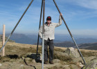
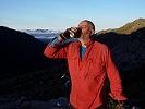
- Attachments
-
- Bluff Hut
-
- View from Mt Eadley Stoney to Mt Buller
-
- Eadley Stoney summit
-
- Square Head Jinny (closer, mid/foreground) and Mt Cobbler behind, from Bluff Hut just before dawn
- LLSC
- Nothofagus gunnii

- Posts: 41
- Joined: Sat 18 Nov, 2017 9:05 am
- Region: Victoria
- Gender: Male
Re: Mount Macdonald - Upper Jamieson Hut track condition
![]() by north-north-west » Sat 18 Dec, 2021 4:52 pm
by north-north-west » Sat 18 Dec, 2021 4:52 pm
There used to be a horse track down via Square Head Jinny. I walked it about ten years ago - more or less followable but reduced to a faint pad. The old 4WD track it empties onto, however, was a wee bit nightmarish due to the approximately 7,592 fallen trees on it. Not to mention regrowth and flood damage.
Fun, in a sick kind of way. Glad you didn't try to go that way.
Fun, in a sick kind of way. Glad you didn't try to go that way.
"Mit der Dummheit kämpfen Götter selbst vergebens."
-

north-north-west - Lagarostrobos franklinii
- Posts: 15493
- Joined: Thu 14 May, 2009 7:36 pm
- Location: The Asylum
- ASSOCIATED ORGANISATIONS: Social Misfits Anonymous
- Region: Tasmania
Re: Mount Macdonald - Upper Jamieson Hut track condition
![]() by paidal_chalne_vala » Sat 18 Dec, 2021 4:56 pm
by paidal_chalne_vala » Sat 18 Dec, 2021 4:56 pm
I enjoyed your trip report. There is usually water flowing next to the 4 x 4 track just before you get to the Lovick's hut when coming from King Billy. There is no tank there as you discovered.I am intrigued about your North Face ascent of Mt. McDonald.
I am still interested in walking to the summit of Mt. McDonald from Low Saddle, up the AAWT. That might have to wait until Nov. 2022.
I am still interested in walking to the summit of Mt. McDonald from Low Saddle, up the AAWT. That might have to wait until Nov. 2022.
Last edited by paidal_chalne_vala on Sun 19 Dec, 2021 8:19 am, edited 1 time in total.
- paidal_chalne_vala
- Lagarostrobos franklinii
- Posts: 2754
- Joined: Sun 22 Jan, 2012 10:30 pm
- ASSOCIATED ORGANISATIONS: VNPA.BTAC.Friends of Baw Baw.Mt.Bogong Club.
- Region: Victoria
- Gender: Male
Re: Mount Macdonald - Upper Jamieson Hut track condition
![]() by Hiking Exped » Sun 19 Dec, 2021 4:25 am
by Hiking Exped » Sun 19 Dec, 2021 4:25 am
Great trip report. Did it last year, but not made it up Mt McDonald yet this year. Nice photos too. The water in the tank at Bluff I only use if the gully is dry. Water in the gully south of the hut much of the year and much better. There is often water about 500m north of Lovicks, right of the track. You are right about camping the night before, but I never do either - live and learn  Lots of Copper Heads about this year.
- Hiking Exped
- Athrotaxis cupressoides
- Posts: 149
- Joined: Wed 13 Oct, 2021 8:05 am
- Region: Victoria
- Gender: Male
Re: Mount Macdonald - Upper Jamieson Hut track condition
![]() by Baeng72 » Sun 19 Dec, 2021 5:55 am
by Baeng72 » Sun 19 Dec, 2021 5:55 am
Nice report and photo!
- Baeng72
- Athrotaxis selaginoides

- Posts: 1222
- Joined: Wed 07 Aug, 2019 2:29 pm
- Region: Victoria
- Gender: Male
Re: Mount Macdonald - Upper Jamieson Hut track condition
![]() by bigkev » Sun 19 Dec, 2021 8:39 am
by bigkev » Sun 19 Dec, 2021 8:39 am
Thanks for the report LLSC, nice photos. I was contemplating a similar walk before our last lockdown - although I was going to try and drop off The Bluff straight down to Brocks Road. I'll probably try and squeeze it in sometime next year.
-
bigkev - Athrotaxis cupressoides
- Posts: 445
- Joined: Sat 30 Jun, 2012 6:44 pm
- Region: Victoria
- Gender: Male
Re: Mount Macdonald - Upper Jamieson Hut track condition
![]() by LLSC » Sun 26 Dec, 2021 8:57 pm
by LLSC » Sun 26 Dec, 2021 8:57 pm
Big Kev, have you seen the posts on 'Bluff Southern Circuit? Andrewbish had some unkind things to say about the route down Jamieson Spur but it was back in 2014. His comments and a few others made me decide to go Refrigerator Gap Track. If you do decide to go down that spur, please report back: I'd love to know the current condition.
- LLSC
- Nothofagus gunnii
- Posts: 41
- Joined: Sat 18 Nov, 2017 9:05 am
- Region: Victoria
- Gender: Male
Re: Mount Macdonald - Upper Jamieson Hut track condition
![]() by bigkev » Wed 29 Dec, 2021 6:02 pm
by bigkev » Wed 29 Dec, 2021 6:02 pm
I'll search the post out LLSC - to be brutally honest I thought I would be bashing through a fair bit of tough regrowth on the last day, however so long as I can push through it in half a day then I can live with it (particularly if it's on the last day). What really does my head in is encountering regrowth/scrub when I'm not mentally switched on for it, bashing up hill covering a few hundred metres an hour when mentally I'd envisaged myself plodding up a nice pad at around 2 or 3 kph does me in. I know a lot of deer hunters use those slopes above Brocks Road so I was thinking that I might pick up some kind of a pad in spots?? I'll post a report if I get around to it.
-
bigkev - Athrotaxis cupressoides
- Posts: 445
- Joined: Sat 30 Jun, 2012 6:44 pm
- Region: Victoria
- Gender: Male
Re: Mount Macdonald - Upper Jamieson Hut track condition
![]() by stevage » Fri 21 Jan, 2022 1:28 pm
by stevage » Fri 21 Jan, 2022 1:28 pm
I did the walk up to Mt McDonald from Brocks Rd maybe 3-4 years ago. We did the daywalk loop (over towards the Nobs then down Nobs Track to Clear Creek Track). It was pretty overgrown, but bearable. Once we came down from the little peak at around 1110m, it got a lot better, and the track up the main spur wasn't heavily vegetated at all.
Mostly it just slowed down our walk a lot. We started out pretty late (1pm? 2pm?) and didn't get back down until maybe 8 or 9pm.
I was fortunate enough to have my bike in the car, so we did a car-bike shuffle which worked really well. Drove up to the end of Clear Creek Track, parked the car, then rode back to the start. On a heavily potholed dirt road like that, I could cycle about as fast as I could drive - around 25kph. Much better than having to do a 6km road slog at the end. Would totally recommend car-bike shuffles.
- stevage
- Atherosperma moschatum

- Posts: 60
- Joined: Tue 26 Jun, 2012 11:38 am
- Region: Victoria
- Gender: Male
Re: Mount Macdonald - Upper Jamieson Hut track condition
![]() by scroggin » Sat 22 Oct, 2022 10:07 am
by scroggin » Sat 22 Oct, 2022 10:07 am
Anyone been up the north ridge to Mt Macdonald from Low Saddle Rd recently?
Curious to know if it's just too overgrown to attempt.
cheers!
Curious to know if it's just too overgrown to attempt.
cheers!
- scroggin
- Athrotaxis cupressoides
- Posts: 122
- Joined: Mon 28 Oct, 2013 11:52 am
- Region: Victoria
- Gender: Male
Re: Mount Macdonald - Upper Jamieson Hut track condition
![]() by LLSC » Sat 22 Oct, 2022 11:49 am
by LLSC » Sat 22 Oct, 2022 11:49 am
I know that people from DELWP recently did a fair bit of work there. I only saw the very start and it looks OK. The person I spoke to said he had not finished: there is still the last bit before Mt McDonald itself. That is, the part that was a scrub bash before, probably still is.
- LLSC
- Nothofagus gunnii
- Posts: 41
- Joined: Sat 18 Nov, 2017 9:05 am
- Region: Victoria
- Gender: Male
Re: Mount Macdonald - Upper Jamieson Hut track condition
![]() by paidal_chalne_vala » Sat 22 Oct, 2022 12:59 pm
by paidal_chalne_vala » Sat 22 Oct, 2022 12:59 pm
The Timber top school students no longer use that route. That tells you something about the scrub bash involved.
- paidal_chalne_vala
- Lagarostrobos franklinii
- Posts: 2754
- Joined: Sun 22 Jan, 2012 10:30 pm
- ASSOCIATED ORGANISATIONS: VNPA.BTAC.Friends of Baw Baw.Mt.Bogong Club.
- Region: Victoria
- Gender: Male
Re: Mount Macdonald - Upper Jamieson Hut track condition
![]() by paidal_chalne_vala » Sat 12 Nov, 2022 1:39 pm
by paidal_chalne_vala » Sat 12 Nov, 2022 1:39 pm
If anyone does have a go at hiking up or down
the Northern ridge of Mount McDonald then I would be
quite interested to hear what condition that route is in. I may yet call DEWLP
in Mansfield and make an enquiry regarding this matter.
the Northern ridge of Mount McDonald then I would be
quite interested to hear what condition that route is in. I may yet call DEWLP
in Mansfield and make an enquiry regarding this matter.
- paidal_chalne_vala
- Lagarostrobos franklinii
- Posts: 2754
- Joined: Sun 22 Jan, 2012 10:30 pm
- ASSOCIATED ORGANISATIONS: VNPA.BTAC.Friends of Baw Baw.Mt.Bogong Club.
- Region: Victoria
- Gender: Male
Re: Mount Macdonald - Upper Jamieson Hut track condition
![]() by Biggles » Mon 14 Nov, 2022 2:09 pm
by Biggles » Mon 14 Nov, 2022 2:09 pm
paidal_chalne_vala wrote:If anyone does have a go at hiking up or down
the Northern ridge of Mount McDonald then I would be
quite interested to hear what condition that route is in. I may yet call DEWLP
in Mansfield and make an enquiry regarding this matter.
You mean Parks Victoria in Mansfield??
I've had several contacts with Ranger Team Leaders working in or around the ANP, based out of Mansfield. Most enquiries have been for areas around Whitfield and Howqua/Brocks Road to North Jamieson River. A group from Bendigo did that walk you mentioned up the north ridge of McDonald on the Cup Day weekend. Not sure if it was a private group or known bushwalking group (through university). Facing the full brunt of storm and tempest over the Spring I imagine it would not have been an easy task, especially not on that particularly weekend!!
Conversation about the weather is the last refuge of the unimaginative.
—Oscar Wilde, 1890.
—Oscar Wilde, 1890.
-

Biggles - Phyllocladus aspleniifolius
- Posts: 512
- Joined: Thu 14 May, 2009 12:14 pm
- Location: Castlemaine & Geelong
- Region: Victoria
- Gender: Male
Re: Mount Macdonald - Upper Jamieson Hut track condition
![]() by paidal_chalne_vala » Tue 20 Dec, 2022 5:37 pm
by paidal_chalne_vala » Tue 20 Dec, 2022 5:37 pm
P.Platt from Bushwalking Victoria walked this partly cleared route recently up the North (?) spur from the Upper Jamieson hut . He said there is still a scrub bash where the track clearing stops before you reach the actual Northern (?)Spur and the Snow Gum area where the vegetation opens up a bit . Then there are some rock bands to scramble up. He then went down to the Nobs track on the AAWT and then returned to the Upper Jamieson river area in one day with
a day pack. There is a possibility that Bushwalking Victoria will clear the AAWT on Mt. McDonald from the Nobs track up to the summit area. I do not know when that will occur. Nor do they really.
a day pack. There is a possibility that Bushwalking Victoria will clear the AAWT on Mt. McDonald from the Nobs track up to the summit area. I do not know when that will occur. Nor do they really.
- paidal_chalne_vala
- Lagarostrobos franklinii
- Posts: 2754
- Joined: Sun 22 Jan, 2012 10:30 pm
- ASSOCIATED ORGANISATIONS: VNPA.BTAC.Friends of Baw Baw.Mt.Bogong Club.
- Region: Victoria
- Gender: Male
Re: Mount Macdonald - Upper Jamieson Hut track condition
![]() by scroggin » Thu 22 Dec, 2022 8:24 pm
by scroggin » Thu 22 Dec, 2022 8:24 pm
Just completed the Mt McDonald, Mt Clear, King Billies & Bluff circuit starting/finishing at Jamieson River.
From just before the knoll to the final saddle is still overgrown but as mentioned the track leading up to that point exists and fairly simple to follow. I found the fallen trees and scrub from where you turn SE off the Mt McDonald Ridge to Nobs Track worse - completely overgrown in parts . That section was a 4WD track when I last walked it 25 odd years ago and the campsite as I remember was located on the NW side of the Nobs Track amongst tall gums.
I camped there, at Chester's Yard and Bluff Waters. Not Chester's Yard as located on OSM maps but the real one with flowing water some 700m NE further on. There's also water flowing south from Bluff Hut and the spring just before the King Billy Camp on Brocks Rd Junction. l didn't find the elusive spring on Mt Clear, but didn't look too hard.
I was surprised I didn't come across anyone else bushwalking, just campers at the King Billy Junction and many 4WDers on Bluff Track. I did try and keep off the track as much as possible following a foot pad around Picture Point before having to scrub bash back to the road. There were some select horse tracks I took including out of Lovick's Hut so didn't pass the spring nearby.
I bush bashed from just before the Bluff Walking Track carpark directly west to Refrigerator Gap Track, It saved a bit of time, but probably not much in effort. It was open enough but with the odd fallen tree to negotiate and scrubby in parts. With 0.3km v 1.5km, it was worth a shot.
I am not match fit and the first two days wasn't overly easy with the scrub and fallen trees and I'm sure my age is playing a part. but still an enjoyable walk none the less and I have finally climbed Mt Clear which has been on my to do list for a long time, ever since I cut that walk short 25 years ago.
- scroggin
- Athrotaxis cupressoides
- Posts: 122
- Joined: Mon 28 Oct, 2013 11:52 am
- Region: Victoria
- Gender: Male
Re: Mount Macdonald - Upper Jamieson Hut track condition
![]() by paidal_chalne_vala » Fri 23 Dec, 2022 8:40 am
by paidal_chalne_vala » Fri 23 Dec, 2022 8:40 am
Well done and thanks for the updates on conditions in the field. The ascent of Mt. McDonald from the Upper Jamieson hut and/ or Low Saddle road is one I have been looking at doing for years now.
Yes that spring just before King Billy Saddle located on the Mt. Clear Management track was flowing well on 17th Dec. 2022.
Yes that spring just before King Billy Saddle located on the Mt. Clear Management track was flowing well on 17th Dec. 2022.
- paidal_chalne_vala
- Lagarostrobos franklinii
- Posts: 2754
- Joined: Sun 22 Jan, 2012 10:30 pm
- ASSOCIATED ORGANISATIONS: VNPA.BTAC.Friends of Baw Baw.Mt.Bogong Club.
- Region: Victoria
- Gender: Male
27 posts
• Page 1 of 1
Who is online
Users browsing this forum: Bing [Bot] and 46 guests