I'm high on inspiration at the moment and planning a walk up on the Serra Range for the middle of the year.
What I know so far:
It's rocky and scrambly, up and down, I'll get scratched and bruised by the scrub. There's no water up there. Roads run either side of the range.
It looks about 50 km as the crow flies but I assume it will be slow going. Does anyone have any estimates of how long it will take? I am thinking 7 days at around 7km a day but that's a complete guess. I'll probably need to leave a water drop up on the range somewhere.
Anyone done the Serra Range or parts of the Serra Range before? Any advice is greatly appreciated.
Thanks,
Sam.
Serra Range Traverse Rosea to Sturgeon
Forum rules
Victoria specific bushwalking discussion. Please avoid publishing details of access to sensitive areas with no tracks.
Victoria specific bushwalking discussion. Please avoid publishing details of access to sensitive areas with no tracks.
12 posts
• Page 1 of 1
Serra Range Traverse Rosea to Sturgeon
![]() by Explorer_Sam » Thu 25 Jan, 2018 3:11 pm
by Explorer_Sam » Thu 25 Jan, 2018 3:11 pm
My Blog- Adventure and Nature Writing- www.sambochristie.wordpress.com
- Explorer_Sam
- Athrotaxis cupressoides

- Posts: 313
- Joined: Thu 01 Mar, 2012 8:33 pm
- Location: Maryborough
- Region: Victoria
- Gender: Male
Re: Serra Range Traverse Rosea to Sturgeon
![]() by jimjim » Thu 25 Jan, 2018 10:05 pm
by jimjim » Thu 25 Jan, 2018 10:05 pm
Hi Sam,
this would be epic and awesome.
In Winter, after any decent rain there will be plenty of water to sniff out so perhaps a food drop would be more appropriate.
I don't know how long the range would take but slow going for sure. It will be a huge advantage if you are comfortable scrambling, as there is lots of rock to negotiate and route finding can be tricky.
Jim
this would be epic and awesome.
In Winter, after any decent rain there will be plenty of water to sniff out so perhaps a food drop would be more appropriate.
I don't know how long the range would take but slow going for sure. It will be a huge advantage if you are comfortable scrambling, as there is lots of rock to negotiate and route finding can be tricky.
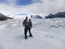
- Looking South along Serra Range. Mt Lubra (L) and Mt Lang (R) etc
Jim
- jimjim
- Athrotaxis cupressoides
- Posts: 110
- Joined: Wed 30 Oct, 2013 9:20 am
- Location: west vic
- Region: Victoria
- Gender: Male
Re: Serra Range Traverse Rosea to Sturgeon
![]() by Explorer_Sam » Fri 26 Jan, 2018 7:07 pm
by Explorer_Sam » Fri 26 Jan, 2018 7:07 pm
jimjim wrote:Hi Sam,
this would be epic and awesome.
In Winter, after any decent rain there will be plenty of water to sniff out so perhaps a food drop would be more appropriate.
I don't know how long the range would take but slow going for sure. It will be a huge advantage if you are comfortable scrambling, as there is lots of rock to negotiate and route finding can be tricky.
Jim
Thanks heaps Jim! I'm certainly comfortable scrambling so that's a bonus. I'm very skeptical about water availability because I've definitely read in the past that there is unlikely to be anything up there. Either way, I could do a water and food drop just to be safe.
That's an awesome shot, by the way.
My next question, what maps would be best for detail on the Serra Range? I have the Southern Grampians map by Spatial Vision but I am wondering if there is something more detailed I could use.
My Blog- Adventure and Nature Writing- www.sambochristie.wordpress.com
- Explorer_Sam
- Athrotaxis cupressoides
- Posts: 313
- Joined: Thu 01 Mar, 2012 8:33 pm
- Location: Maryborough
- Region: Victoria
- Gender: Male
Re: Serra Range Traverse Rosea to Sturgeon
![]() by Eremophila » Wed 31 Jan, 2018 8:48 pm
by Eremophila » Wed 31 Jan, 2018 8:48 pm
Hi Sam,
Be aware the "Serra Terror" is held on June long weekend, if you're keen to avoid lots of people: http://www.dunkeldadventure.com.au/serr ... vent-info/
I think they change their route each year.
Happy to help out with food/water drops or car shuffle, if on a weekend.
Be aware the "Serra Terror" is held on June long weekend, if you're keen to avoid lots of people: http://www.dunkeldadventure.com.au/serr ... vent-info/
I think they change their route each year.
Happy to help out with food/water drops or car shuffle, if on a weekend.
-
Eremophila - Phyllocladus aspleniifolius

- Posts: 931
- Joined: Mon 24 Oct, 2011 5:15 pm
- Location: SW Vic
- Region: Victoria
- Gender: Female
Re: Serra Range Traverse Rosea to Sturgeon
![]() by Bushwakka » Mon 06 Feb, 2023 2:16 pm
by Bushwakka » Mon 06 Feb, 2023 2:16 pm
Hi guys. Not sure if this thread is dead or not but I'm looking at doing the Serra range traverse and am wondering if there was any update on water availability i.e. was it possible to find water along the way of did you do drops? I understand it varies season by season.
Cheers
Cheers
- Bushwakka
- Nothofagus cunninghamii

- Posts: 1
- Joined: Mon 06 Feb, 2023 2:14 pm
- Region: Victoria
- Gender: Female
Re: Serra Range Traverse Rosea to Sturgeon
![]() by CraigVIC » Tue 07 Feb, 2023 10:12 am
by CraigVIC » Tue 07 Feb, 2023 10:12 am
This is a walk that essentially does not exist. There are some barely walked informal tracks on some peaks but they don't constitue a continuous route. Certainly it has been done but I've never been able to find anything like a trip report.
- CraigVIC
- Phyllocladus aspleniifolius
- Posts: 632
- Joined: Tue 24 Oct, 2017 6:20 pm
- Region: Victoria
Re: Serra Range Traverse Rosea to Sturgeon
![]() by scroggin » Tue 07 Feb, 2023 11:34 am
by scroggin » Tue 07 Feb, 2023 11:34 am
There is a trip report in an old Wild magazine that I did have but got rid of all of them (30 odd) in a cleanout a few months ago  .
.
I think the plan was to make it to Teddy Bear Gap from Rosea, but didn't make it that far.
I think the plan was to make it to Teddy Bear Gap from Rosea, but didn't make it that far.
Last edited by scroggin on Wed 08 Feb, 2023 8:16 am, edited 1 time in total.
- scroggin
- Athrotaxis cupressoides
- Posts: 122
- Joined: Mon 28 Oct, 2013 11:52 am
- Region: Victoria
- Gender: Male
Re: Serra Range Traverse Rosea to Sturgeon
![]() by bernieq » Tue 07 Feb, 2023 7:47 pm
by bernieq » Tue 07 Feb, 2023 7:47 pm
This !CraigVIC wrote:This is a walk that essentially does not exist.
Serra - as in serrated. There is a lot of steep up & down. I've walked a few sections as overnight, out & back, walks and it's hard going. There is no water up on the range - in any season.
Much of the roads on either side are MVO so placing a food & water drop becomes quite difficult.
We are responsible for the health of the planet - not it for ours
-
bernieq - Phyllocladus aspleniifolius
- Posts: 724
- Joined: Tue 17 Jan, 2012 3:43 pm
- Region: Victoria
Re: Serra Range Traverse Rosea to Sturgeon
![]() by Baeng72 » Wed 08 Feb, 2023 9:24 am
by Baeng72 » Wed 08 Feb, 2023 9:24 am
This intrigued me. I'm no expert local, so the following is just musings.
I think this would be a challenge.
I got the idea for this from some of the NSW canyoners on how they plan routes. I can't remember any names, but don't blame them if this is nonsense.
If I were planning on doing this, I'd download QGIS, get topo maps from GetLost (free maps - need Grampians, Fyans, Watgania and Thackeray), and then go to Elvis and get elevation data, reproject it to the same projection as GetLost maps (or vice-versa), then using the profile plugin for QGIS, trace out possible paths. The interesting thing about the profile tool is apart from a height profile, you get slope/angle profile. Which can tell you (within the limits of your elevation data) how steep a path might be. But it's not perfect. For Example, Helicopter Spur approaches 100% slope (1 meter flat is 1 meter up), but can't tell you there's rock bands where you are more or less scrambling. It gives something like 60% slope for parts of Stanley Name Spur (which again scrambling), so it doesn't tell if your scrambling or just a steep hill. I'd probably look at Google Earth satellite data of a proposed path.
But it's something I do for a place I've never been, not sure it helps, because I always imagine I'm up to the challenge, then often find I'm not....And the topo maps/elevation data can't really help with vegetation info.
Using the above, this is from Rosea Carpark to Mt Rosea summit (which I've walked in 2019, so can't be hard The 60% slope near the Grand Stairway might be an error going off track a bit with the path or not, I don't remember ).
).
Tracing a potential path after leaving Mt Rosea summit would be where the fun starts, although as an intellectual exercise, I imagine not so much fun in reality - although I've read people report on Dalton Peak hikes, so there's probably tracks that resemble nothing like the path I traced by eyeballing the topo map.
Anyway, just my musings.
I think this would be a challenge.
I got the idea for this from some of the NSW canyoners on how they plan routes. I can't remember any names, but don't blame them if this is nonsense.
If I were planning on doing this, I'd download QGIS, get topo maps from GetLost (free maps - need Grampians, Fyans, Watgania and Thackeray), and then go to Elvis and get elevation data, reproject it to the same projection as GetLost maps (or vice-versa), then using the profile plugin for QGIS, trace out possible paths. The interesting thing about the profile tool is apart from a height profile, you get slope/angle profile. Which can tell you (within the limits of your elevation data) how steep a path might be. But it's not perfect. For Example, Helicopter Spur approaches 100% slope (1 meter flat is 1 meter up), but can't tell you there's rock bands where you are more or less scrambling. It gives something like 60% slope for parts of Stanley Name Spur (which again scrambling), so it doesn't tell if your scrambling or just a steep hill. I'd probably look at Google Earth satellite data of a proposed path.
But it's something I do for a place I've never been, not sure it helps, because I always imagine I'm up to the challenge, then often find I'm not....And the topo maps/elevation data can't really help with vegetation info.
Using the above, this is from Rosea Carpark to Mt Rosea summit (which I've walked in 2019, so can't be hard The 60% slope near the Grand Stairway might be an error going off track a bit with the path or not, I don't remember
- Mt Rosea carprk to Summit Topo
- Mt Rosea carprk to Summit height profile
- SERRA-01-height.png (8.07 KiB) Viewed 8172 times
- Mt Rosea carprk to Summit slope profile
- SERRA-01-slope.png (13.68 KiB) Viewed 8172 times
Tracing a potential path after leaving Mt Rosea summit would be where the fun starts, although as an intellectual exercise, I imagine not so much fun in reality - although I've read people report on Dalton Peak hikes, so there's probably tracks that resemble nothing like the path I traced by eyeballing the topo map.
- Mt Rosea to D'Alton Peak via some bumps (horrible ms-paint stitching together)
- Mt Rosea to D'Alton Peak height profile
- SERRA-02-height.png (11.13 KiB) Viewed 8172 times
- Mt Rosea to D'Alton Peak slop profile
- SERRA-02-slope.png (13.88 KiB) Viewed 8172 times
Anyway, just my musings.
Last edited by Baeng72 on Wed 08 Feb, 2023 9:32 am, edited 1 time in total.
- Baeng72
- Athrotaxis selaginoides

- Posts: 1222
- Joined: Wed 07 Aug, 2019 2:29 pm
- Region: Victoria
- Gender: Male
Re: Serra Range Traverse Rosea to Sturgeon
![]() by Baeng72 » Wed 08 Feb, 2023 9:26 am
by Baeng72 » Wed 08 Feb, 2023 9:26 am
bernieq wrote:Serra - as in serrated. There is a lot of steep up & down. I've walked a few sections as overnight, out & back, walks and it's hard going. There is no water up on the range - in any season.
Serra means Saw in Latin I think. The Spanish word Sierra (saw/jagged mountain range) is from this root word. Hence Sierra Nevada (Snowy [jagged] mountains).
- Baeng72
- Athrotaxis selaginoides
- Posts: 1222
- Joined: Wed 07 Aug, 2019 2:29 pm
- Region: Victoria
- Gender: Male
Re: Serra Range Traverse Rosea to Sturgeon
![]() by AbruptTiger19 » Thu 09 Feb, 2023 8:56 pm
by AbruptTiger19 » Thu 09 Feb, 2023 8:56 pm
According to the wild magazine, it has been done. Now, needless to say I wouldn't even begin to recommend doing this. Making it much past D'alton Peaks alone would be an incredible feat. The only fully tracked peaks of the Serra Range are Mount Rosea, Mount Burchell, Signal Peak, Mount Abrupt, The Piccaninny, and Mount Sturgeon. If you choose to go ahead on the traverse, good luck with the scrub.
- AbruptTiger19
- Nothofagus cunninghamii
- Posts: 6
- Joined: Thu 23 Dec, 2021 7:32 pm
- Region: Victoria
Re: Serra Range Traverse Rosea to Sturgeon
![]() by paidal_chalne_vala » Mon 06 Mar, 2023 8:26 am
by paidal_chalne_vala » Mon 06 Mar, 2023 8:26 am
Al I can see here is type 3 fun possibly type 4 fun if you slip and fall and badly injure yourself.
:-0
:-0
- paidal_chalne_vala
- Lagarostrobos franklinii

- Posts: 2754
- Joined: Sun 22 Jan, 2012 10:30 pm
- ASSOCIATED ORGANISATIONS: VNPA.BTAC.Friends of Baw Baw.Mt.Bogong Club.
- Region: Victoria
- Gender: Male
12 posts
• Page 1 of 1
Who is online
Users browsing this forum: No registered users and 38 guests