Page 1 of 1
When plans change

Posted:
Mon 25 Jan, 2021 9:20 pmby Dexter
I had a walk planned in the prom 29th - 1st... and due to some very unfortunate circumstances with one of my friends, she can't make it along. However she will be back in Melb and free on Sunday the 31st, and since we've taken leave till the 2nd we are wondering about what we could do.
At this stage we are thinking about staying a little closer to Melbourne, perhaps around 2 hours. Staying somewhere as a base camp with car etc for a night, then either doing a smaller over night hike or perhaps just day walks. I had a look at Cathedral Ranges, but those walks look pretty intense! We have done a few overnight walks, but not sure if we are up for some Grade 5 action yet! Any suggestions?
(note that we just did the Beeripmo Walk a couple of weeks back, so something different would be nice).
Re: When plans change
Posted:
Mon 25 Jan, 2021 9:43 pmby Baeng72
2 suggestions:
1. The walk into History (near Warburton). Drive to Starling's Gap campsite, setup tent, walk to the Ada tree and return in a day (or crash at Fed. Mill or Ada No. 2 mill sites and return next day to car if you want an overnighter with possible Lyrebird chorus). Or Drive to Big Pat's Creek, take the gentle stroll Up to Starting's Gap campsite, setup camp, then walk to the other places with a day pack. Return to Big Pat's the day after.
2. Camp either at 'The Gums' in Kinglake NP and drive to walks like Masons Falls circuit/Wombalano Falls/etc. Or camp at Murrundindi Scenic reserve and do Wilhelmena falls or Toolangi as a day walk (or any walk in Kinglake NP because they're all within a shortish drive while camping at Murrundindi).
So camp at 1 of those places and smorgasbord the walks to your liking).
Both campsites cost. Murrundindi is $7 (basicallly on an honors system, but you'll be in the company of trail bikers who may celebrate their trail biking at night), The Gums is very much a 'family's first campsite' affair' and costs $30 if I remember.
Re: When plans change
Posted:
Mon 25 Jan, 2021 9:57 pmby Dexter
Baeng72 wrote:2 suggestions:
1. The walk into History (near Warburton). Drive to Starling's Gap campsite, setup tent, walk to the Ada tree and return in a day (or crash at Fed. Mill or Ada No. 2 mill sites and return next day to car if you want an overnighter with possible Lyrebird chorus). Or Drive to Big Pat's Creek, take the gentle stroll Up to Starting's Gap campsite, setup camp, then walk to the other places with a day pack. Return to Big Pat's the day after.
2. Camp either at 'The Gums' in Kinglake NP and drive to walks like Masons Falls circuit/Wombalano Falls/etc. Or camp at Murrundindi Scenic reserve and do Wilhelmena falls or Toolangi as a day walk (or any walk in Kinglake NP because they're all within a shortish drive while camping at Murrundindi).
So camp at 1 of those places and smorgasbord the walks to your liking).
Both campsites cost. Murrundindi is $7 (basicallly on an honors system, but you'll be in the company of trail bikers who may celebrate their trail biking at night), The Gums is very much a 'family's first campsite' affair' and costs $30 if I remember.
Awesome! Yeah I actually spotted something similar to Option 1 on AllTrails, and was trying to work out a good route using those campsites. I'll go over that one on a map, it might be a goer! Cheers.
Re: When plans change
Posted:
Mon 25 Jan, 2021 11:12 pmby crollsurf
Plan A walk with your friend. Plan B, it's just you. Promise you plan B is a good plan.
Re: When plans change
Posted:
Tue 26 Jan, 2021 12:41 pmby Baeng72
Speaking of plans changing....I was at Gunammatta beach yesterday as the boys love to splash in the surf.
I rolled on my foot in the carpark (there's a big pothole I'll report to Parks so they can fix it), did a bit of a tumble, and lost a bit of skin off my arm and hand, but got up and had a splash in the surf.
The foot started to swell in the evening, but I just assumed a bit bruised.
It got worse by this morning and Hospital says broken metatarsal and need to rest & moonboot for 4 weeks.
So, no planned trip to Prom in two weeks.
I can't take a trick with bushwalking at the moment!
Re: When plans change
Posted:
Tue 26 Jan, 2021 12:48 pmby Dexter
crollsurf wrote:Plan A walk with your friend. Plan B, it's just you. Promise you plan B is a good plan.
Well, it's a group of 3 of us and 1 can't get there on time. So it's more a case of putting that walk on ice until we can all enjoy it together. I'm not super keen walking alone. Mostly because I just prefer to have someone else there to reflect on it, and share the trip with. Otherwise I'd be debriefing with people who weren't there and don't care that much haha. It's hard to explain, but probably the same reason I can't see myself going off to the movies alone. I don't care about being a loner, but just like to discuss it afterwards and have someone to share it with - if that makes sense. I know a lot of people love the solitude and to a certain level I think I probably would too. But if it's a choice between going on the walk there alone, or doing a short trip with friends... I'd rather do the later.
Re: When plans change
Posted:
Tue 26 Jan, 2021 12:52 pmby Dexter
Baeng72 wrote:Speaking of plans changing....I was at Gunammatta beach yesterday as the boys love to splash in the surf.
I rolled on my foot in the carpark (there's a big pothole I'll report to Parks so they can fix it), did a bit of a tumble, and lost a bit of skin off my arm and hand, but got up and had a splash in the surf.
The foot started to swell in the evening, but I just assumed a bit bruised.
It got worse by this morning and Hospital says broken metatarsal and need to rest & moonboot for 4 weeks.
So, no planned trip to Prom in two weeks.
I can't take a trick with bushwalking at the moment!
Oh man! What terrible luck.

I'd imagine a metatarsal break doesn't cause too many complications though? At least you didn't do your ACL or something. Get well soon.
Re: When plans change
Posted:
Tue 26 Jan, 2021 12:54 pmby Baeng72
Thanks!
No complications, it just need time to mend.
Re: When plans change
Posted:
Tue 26 Jan, 2021 1:04 pmby CraigVIC
You could probably modify your trip (depending on bookjngs/availability) and do a shorter version of the prom. It's nice enough that it won't 'ruin' the possibility of coming back later to do the full loop.
Re: When plans change
Posted:
Tue 26 Jan, 2021 1:15 pmby Dexter
CraigVIC wrote:You could probably modify your trip (depending on bookjngs/availability) and do a shorter version of the prom. It's nice enough that it won't 'ruin' the possibility of coming back later to do the full loop.
Yeah we thought about that. But I guess since plans were going to change we decided to have a look around at options. Starling's Gap looks like a cool place to base ourselves. Have to say I don't mind the idea of a nights car camp with a few beers as well

Re: When plans change
Posted:
Tue 26 Jan, 2021 4:07 pmby Staceykate
Cathedral ranges isn't that bad, especially if you are just doing the northern circuit with only a day pack and camping at the parks site at the bottom.
I took a couple of teenagers and some more "newbies" a few weeks ago, and as long as you are fit it should be ok.
Take lunch, heaps of water and start early.
It's hard, but if you've done overnights it's probably not as bad as you think.
Re: When plans change
Posted:
Tue 26 Jan, 2021 10:51 pmby EGM
[quote="Baeng72"]Speaking of plans changing....I was at Gunammatta beach yesterday as the boys love to splash in the surf.
I rolled on my foot in the carpark (there's a big pothole I'll report to Parks so they can fix it), did a bit of a tumble, and lost a bit of skin off my arm and hand, but got up and had a splash in the surf.
The foot started to swell in the evening, but I just assumed a bit bruised.
It got worse by this morning and Hospital says broken metatarsal and need to rest & moonboot for 4 weeks.
So, no planned trip to Prom in two weeks.
I can't take a trick with bushwalking at the moment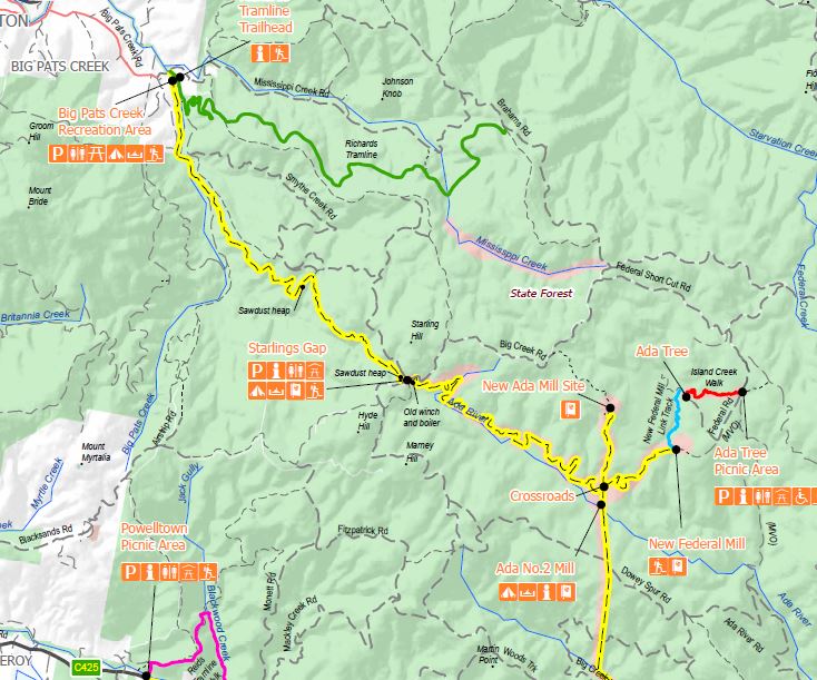
- Walk into history
- WIH.JPG (108.94 KiB) Viewed 16019 times
Re: When plans change
Posted:
Thu 28 Jan, 2021 10:29 amby Dexter
Yeah no worries. I'll carry enough unless I hear differently from someone.
Yeah we will backtrack, usually I prefer loops but everything looks a bit different in reverse
. There looks like theres's a trestle bridge not far off the track that we might check out on the way down. Looks like a pretty interesting place. Thanks again!
Re: When plans change
Posted:
Fri 29 Jan, 2021 8:33 amby indented
I did Starlings to Ada tree and back late December 2019, camped at Ada No2. There's a swampy section with duckboard over it between Starlings and the crossroads, and another perhaps 100m before you get to Ada No2. Both were flowing well but shallow.
Between the crossroads and New Federal Mill site there was a crossing of the Little Ada River which was much more substantial. There were rocks to cross on but appeared to be at least knee deep and strong flow.
Re: When plans change
Posted:
Fri 29 Jan, 2021 8:39 amby ccar
What software / mapping service is this, if you don't mind me asking?
Thanks
Re: When plans change
Posted:
Fri 29 Jan, 2021 8:50 amby Dexter
indented wrote:I did Starlings to Ada tree and back late December 2019, camped at Ada No2. There's a swampy section with duckboard over it between Starlings and the crossroads, and another perhaps 100m before you get to Ada No2. Both were flowing well but shallow.
Between the crossroads and New Federal Mill site there was a crossing of the Little Ada River which was much more substantial. There were rocks to cross on but appeared to be at least knee deep and strong flow.
Thanks for that. Good to know. Might be interesting crossing at the moment given there's been more rain.
ccar wrote:What software / mapping service is this, if you don't mind me asking?
Thanks
I believe it's just the map from this PDF.
https://www.visitwarburton.com.au/sites ... ory_lr.pdf
Re: When plans change
Posted:
Fri 29 Jan, 2021 8:58 amby Baeng72
Dexter is correct, I took a screen grab of the map from that document.
Similar maps available in these documents:
https://www.ffm.vic.gov.au/__data/asset ... istory.pdf,
https://www.ffm.vic.gov.au/__data/asset ... df-map.pdf
Re: When plans change
Posted:
Fri 29 Jan, 2021 9:17 amby ccar
Cheers guys
Re: When plans change
Posted:
Tue 02 Feb, 2021 7:38 amby indented
Spotted a report on Facebook (Hiking & Bushwalking in Victoria group) for Starlings - Ada tree this past weekend. Many downed trees, lots of leeches and the water was above the stepping stones at the Little Ada crossing after the crossroads.
Re: When plans change
Posted:
Tue 02 Feb, 2021 10:04 pmby Dexter
Yeah can confirm all of that. Just got back and saw no one the whole time. It was bliss! Apart from the leeches that is.
I spoke to a couple of maintenance crew at Starlings Gap. They said they haven't got around to doing any clearing for 12 months and asked me how it was. Told them there's a lot of climbing over trees and branches. They said they'd be clearing in the next week or two. Beautiful walk though. Highly recommended.
Sent from my Pixel 3 XL using Tapatalk
Re: When plans change
Posted:
Wed 03 Feb, 2021 9:24 amby Baeng72
Thanks for the update Dexter!
Sounds like you had a good walk.
Re: When plans change
Posted:
Wed 03 Feb, 2021 10:43 amby Dexter
Baeng72 wrote:Thanks for the update Dexter!
Sounds like you had a good walk.
Cheers! We had a great time. We ended up changing our route a little, but plan on going back to do the full 'walk into history'.