Page 1 of 2
Snowy Plains track notes

Posted:
Tue 16 Nov, 2021 1:00 pmby Lophophaps
This thread is for all information about the Snowy Plains in Victoria.
The usual way to Howitt Car Park is via Licola, Tamboritha Saddle and north. From the car park a road drops steeply to the Macalister River, then west to near King Billy. Is it possible to come up Brocks Road, go down to the Macalister and up to the car park? I'm advised that it may be possible to go from Licola via the Macalister to gain access to the car park from the west.
Does anyone know anything about these two options?
Re: Snowy Plains track notes
Posted:
Tue 16 Nov, 2021 2:27 pmby Biggles
Following.
Can't add information (know the roads you are mentioning, but not the links), and familiar with parts of the area N of Licola. This is where my Christmas/NY holidays will be spent, walking, mountain biking and exploring the usual alpine haunts from at/near Guys Hut. Where is the assumed turn-off on Brocks Road? I've travelled that road as far as the Mount Clear Tk on the left. The Knobs Tk??
Re: Snowy Plains track notes
Posted:
Wed 17 Nov, 2021 7:03 amby Xplora
Not sure if Lops is referring to Low Saddle road that runs south from Brocks Road near where the Refrigerator Gap track joins Brocks Road. Low Saddle Road joins up with Mt. Sunday Road and then AAWT to the Berkley River jeep track and down to Rumpff Saddle and to Licola.
The only other two tracks I know off the Howitt Road are very serious 4wd. Calendonia River track and Butcher country.
Re: Snowy Plains track notes
Posted:
Wed 17 Nov, 2021 7:25 amby Baeng72
This might help?
Photos of maps of the offending are, roughly in order of usefulness:
Adventure Map
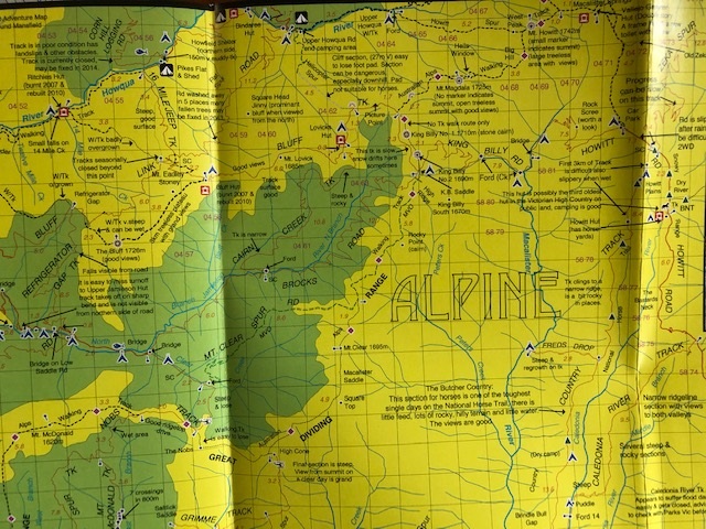
- Adventure map
- Roof.JPG (177.33 KiB) Viewed 18685 times
SV Map
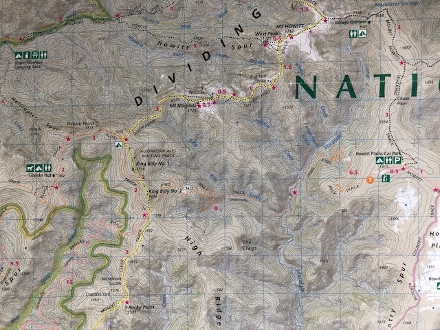
- SV Maps
- SVMaps.JPG (183.66 KiB) Viewed 18685 times
Brookes walking map
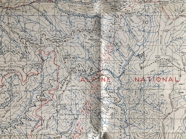
- Brooks
- Brooks.JPG (217.36 KiB) Viewed 18685 times
Re: Snowy Plains track notes
Posted:
Wed 17 Nov, 2021 7:32 amby bernieq
It's called the King Billy Track (from Brock's Rd, in the saddle sth of KB1 to Howitt Rd (ie carpark for Mac Springs)).
Look it up on 4x4 websites - I think you'll find it's drivable with high clearance (but definitely 4x4)
Re: Snowy Plains track notes
Posted:
Wed 17 Nov, 2021 8:02 amby Lophophaps
Thanks. The advice from Licola via the Macalister was uncertain, and I could not see how this could be done. Knowing that King Billy Track is serious 4WD is useful. I have Stuart Brookes Watersheds map ... 1986. At the time they and Algona were often the best maps. My Algona maps on plastic were waterproof, but in time the plastic degrades to small chips.
Re: Snowy Plains track notes
Posted:
Wed 17 Nov, 2021 6:41 pmby paidal_chalne_vala
Al those routes are serious 4 WD only. In Dec. I plan to walk up Brock's road from The Upper Jamieson River near where the winter gate is located on Brock's road and go over KB saddle down to the Mac. River and up to the Howitt Plains and VG hut as a green season fact finding mission for XC BC ski touring access to VG hut at Mac. Springs. I will return via Hell's window and Lovick's hut and Cairn Creek track.
Re: Snowy Plains track notes
Posted:
Thu 18 Nov, 2021 4:31 amby Xplora
paidal_chalne_vala wrote:Al those routes are serious 4 WD only. In Dec. I plan to walk up Brock's road from The Upper Jamieson River near where the winter gate is located on Brock's road and go over KB saddle down to the Mac. River and up to the Howitt Plains and VG hut as a green season fact finding mission for XC BC ski touring access to VG hut at Mac. Springs. I will return via Hell's window and Lovick's hut and Cairn Creek track.
I really don't know why you would do that to get to VG hut in winter when you can go via Magdalla from the King Billys, ski most of the way, and be there a day quicker at the very least. You climb all the way up from the gate near Cairn Creek only to go down to the MacAllister and then back up again. I think if you ever did this in a 4wd you would quickly realise it would not work for good winter access to VG hut but let me know how you go with it.
Re: Snowy Plains track notes
Posted:
Thu 18 Nov, 2021 7:12 amby paidal_chalne_vala
The XC skiing with a heavy pack over Mt. Magdala could become hairy in poor visibility even via the low track. The descent from KB could become tricky for this plodder on planks.
The summit of Mt. Howitt in white season could become an ordeal when it comes to finding the track to VG hut in a white out even with a map compass and GPS. Of course one plans
such ski tours when the weather window is good but the weather can change suddenly up there in white season.
As a bushwalk I want to see what the route I have described is like . The approach from Gorge Gap and the winter gate there on the Howitt road is further but has less up and down. There is no easy way to Mac. Springs in white season.
Re: Snowy Plains track notes
Posted:
Thu 18 Nov, 2021 11:52 amby north-north-west
paidal_chalne_vala wrote:There is no easy way to Mac. Springs in white season.
Helicopter? Not cheap, but quick and easy as long as the weather is decent.
I've looked at the Caledonia/Butcher Country Tracks and even with the Hilux they were much too full on for me. It would not be easy walking, but an interesting trip as long as you get it without the 4WDers.
Re: Snowy Plains track notes
Posted:
Thu 18 Nov, 2021 1:40 pmby Lophophaps
Re: Snowy Plains track notes
Posted:
Thu 18 Nov, 2021 2:32 pmby Baeng72
A whiteout on Howitt looks like a whiteout near Pole 333. Are you recycling photos Lops?

Must be a bit sphincter clenching to be in that situation, with precipitous drops nearby.
Re: Snowy Plains track notes
Posted:
Thu 18 Nov, 2021 3:42 pmby Lophophaps
It's on Magdala and Howitt. I have not been near pole 333 in a whiteout. The most memorable whiteout was on the Etheridge Range on the ridge southish of the hut. Paul was next to me and he vanished, gone in an instant. Either the cornice gave way or he skied off the edge - we never found out. It took about 30 minutes for him to get back to the party. His first words were along the lines that there was no wind where he was.
On Howitt we were very mindful of the big drops on the Crosscut side of the summit. The third picture is when it cleared for a few minutes and we could see the way. That was a difficult day. Skiing up the Bluff was not a good idea. Sidestep, slip on ice. Take the skis off, knee to thigh deep.
Re: Snowy Plains track notes
Posted:
Thu 18 Nov, 2021 3:56 pmby GBW
Yes you wouldn't want to take a wrong turn on Magdala in a whiteout.
You can find videos of all the tracks leading to Howitt Rd on Youtube; King Billy, Macalister River/Butchers/Caledonia River. Very popular with 4WD/trail bike enthusiasts. I think the easiest way is via Brocks and the AAWT but King Billy Track is only 11k to the Howitt carpark and flat from there. Good if the weather is bad. Macalister River/Butchers is part of the BNT onto Dry River Track into the Wonnangatta where the two campers disappeared.
Re: Snowy Plains track notes
Posted:
Thu 18 Nov, 2021 3:59 pmby Baeng72
Lophophaps wrote:It's on Magdala and Howitt. I have not been near pole 333 in a whiteout. The most memorable whiteout was on the Etheridge Range on the ridge southish of the hut. Paul was next to me and he vanished, gone in an instant. Either the cornice gave way or he skied off the edge - we never found out. It took about 30 minutes for him to get back to the party. His first words were along the lines that there was no wind where he was.
The vaguaries of memory, I'd though you'd mentioned a whiteout near Pole 333 and the photo you posted today was similar to the one I vaguely remembered.
Turns out the last photo in the link was near Pole 333.
https://bushwalk.com/forum/viewtopic.ph ... ut#p412331
Re: Snowy Plains track notes
Posted:
Thu 18 Nov, 2021 4:13 pmby GBW
That's the beauty of whiteout photos. You can say they're anywhere you want.
Re: Snowy Plains track notes
Posted:
Thu 18 Nov, 2021 8:33 pmby Lophophaps
GBW wrote:That's the beauty of whiteout photos. You can say they're anywhere you want.
I was wondering how long it would take you to realise that the picture is actually on the Larapinta.
Re: Snowy Plains track notes
Posted:
Fri 19 Nov, 2021 6:17 amby Xplora
paidal_chalne_vala wrote:The XC skiing with a heavy pack over Mt. Magdala could become hairy in poor visibility even via the low track. The descent from KB could become tricky for this plodder on planks.
The summit of Mt. Howitt in white season could become an ordeal when it comes to finding the track to VG hut in a white out even with a map compass and GPS. Of course one plans
such ski tours when the weather window is good but the weather can change suddenly up there in white season.
As a bushwalk I want to see what the route I have described is like . The approach from Gorge Gap and the winter gate there on the Howitt road is further but has less up and down. There is no easy way to Mac. Springs in white season.
So the point is avoiding the possibility of a difficult ski. What do you do once at Mac Springs? Not much easy skiing to be had. I guess once you walk it you will understand what I was trying to advise you. It could be better for you to stay on the Snowy Plains and tour around.
Re: Snowy Plains track notes
Posted:
Fri 19 Nov, 2021 8:37 amby paidal_chalne_vala
Yes, I think you could be right about that. So coming in from Gorge Gap on the Howitt road could be smarter and better for my Nordic skiing ability.
A trip to Kelly's hut & McMichael's hut ( the better of the two huts )
could be even better suited to what I want to do .
Vehicular access
could become the real hurdle using that route. Arbuckle Junction is subject to large snow drifts in winter and early spring and the road area from Tamboritha Saddle to the winter gates at Gorge Gap receives many fallen trees in winter.
Even so I am curious about the route I have described merely as a Bushwalker and will most likely do it anyway just because it covers some terrain( mostly 4 x 4 tracks ) I have not walked in the area.
Re: Snowy Plains track notes
Posted:
Sat 20 Nov, 2021 7:05 amby Xplora
paidal_chalne_vala wrote:Yes, I think you could be right about that. So coming in from Gorge Gap on the Howitt road could be smarter and better for my Nordic skiing ability.
A trip to Kelly's hut & McMichael's hut ( the better of the two huts )
could be even better suited to what I want to do .
Vehicular access
could become the real hurdle using that route. Arbuckle Junction is subject to large snow drifts in winter and early spring and the road area from Tamboritha Saddle to the winter gates at Gorge Gap receives many fallen trees in winter.
That just means you will have the skis on sooner. If the object is to ski tour this would be better than lugging a heavy pack with skis and boots for two days up and down and another two days to return.
paidal_chalne_vala wrote:Even so I am curious about the route I have described merely as a Bushwalker and will most likely do it anyway just because it covers some terrain( mostly 4 x 4 tracks ) I have not walked in the area.
It is not a bushwalk but if you like walking on roads and sharing it with the cars then it may be OK for you. It is all 4wd track. Perhaps my judgement of it is clouded by having driven it many times and you may find it nice but I can think of many other walks that would take up my time before this one. You still have to get over the Crosscut to Speculation. I know the type of skiing you like and cannot see enough at Mac Springs (apart from the 5km in from the Howitt carpark) that would occupy you. The advice is free, the choice is yours.
Re: Snowy Plains track notes
Posted:
Sat 20 Nov, 2021 8:28 amby paidal_chalne_vala
The Bogong High Plains are still my main focus for XC skiing. That large undulating treeless area is my home away from home. I know LOPS loves it too.
Mac. Springs is simply a case of wanting to visit and utilize the hut in white season. The approach from Gorge Gap/ Howitt road would require two proper 4 x 4 vehicles and at least two chainsaws.
I am looking at doing other green season hikes that get away from 4WD tracks including Young's Top and a circuit of Mt. Bogong which would include a return to the dreaded T spur .
Re: Snowy Plains track notes
Posted:
Mon 22 Nov, 2021 9:21 amby CaptainC
I was on the Wellington Plains over last weekend and met a woman who had come from Mt Howitt. She said the road to Mt Howitt is currently suitable only for 4WD due to pot holes etc.
Re: Snowy Plains track notes
Posted:
Mon 22 Nov, 2021 11:29 amby neilmny
Lophophaps wrote:GBW wrote:That's the beauty of whiteout photos. You can say they're anywhere you want.
I was wondering how long it would take you to realise that the picture is actually on the Larapinta.

Re: Snowy Plains track notes
Posted:
Mon 29 Nov, 2021 9:02 amby Lophophaps
Northbound on the AAWT at the Magdala-Lovicks junction the track goes downhill. I'm advised that a short way down that track there's water to the south-east. At the treeline on the south side of Howitt, about 1670 metres, there may be water to the east
Is this water reliable, or might it be just in summer or after substantial precipitation?
Re: Snowy Plains track notes
Posted:
Mon 29 Nov, 2021 5:39 pmby paidal_chalne_vala
The Howitt creek water is signposted as you walk over the summit area of Mt. Howitt. It is a homemade sign.
Some water in the King Billy area is a trickle cum soak which usually runs dry by Xmas each year and is not far from the camp site the The Timbertop groups use. The track near KB 1 where it forks off northwards towards Mt. Magdala on the AAWT is not hard to locate. The School groups have tagged the footpad with markers on tree boughs and tree trunks.
Re: Snowy Plains track notes
Posted:
Sun 02 Jan, 2022 4:03 pmby paidal_chalne_vala
The Howitt Road is SUV/ AWD standard up until it meets the King Billy track.
Then it becomes high clearance 4 x4 access to the Macalister river.
The view of Mt. Magdala from that point is noteworthy . There is a rough camp site of sorts above the road with a parking area at that road junction.
Re: Snowy Plains track notes
Posted:
Sun 13 Feb, 2022 8:47 amby paidal_chalne_vala
Parks Vic. have sent in contractors to Grade the Howitt road. Contact the P.V. Heyfield office for more details before you set off.
Re: Snowy Plains track notes
Posted:
Tue 27 Sep, 2022 7:00 pmby Lophophaps
Open Street Maps have a campsite on Howitt on the AAWT, roughly half way between the summit and the Crosscut junction. There's a track going down to the gully or creek.
https://bushwalk.com/forum/viewtopic.ph ... lit=HowittAs far as I can recall that section is exposed, good enough for a calm night, but that's all. Also, being on the north side of the track is not as good as being on the south side. Is the water reliable? Is there a track to the water? Apart from Stanleys Name Spur, Mac Springs and Magdala, are there any other nearby water sources?
Re: Snowy Plains track notes
Posted:
Wed 28 Sep, 2022 8:19 pmby bernieq
Yes, it's very exposed and not all that great a spot, really. No shade & muddy if wet. Better is amongst a few trees on a knoll 3-400m towards Mac Springs. It's still quite exposed but a great spot in moderate weather.
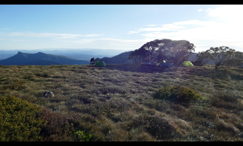
- on Mt Howitt - photo Nov 2021
- Screenshot_20220928-195346_DS photo.jpg (139.43 KiB) Viewed 8135 times
There is the beginnings of a footpad, but not a track, to the spring and it isn't all that reliable. Actually, I've found it unpredictable - sometimes little water when I expected a good flow.
No other water sources that I know (by Magdala, I guess you mean Hellfire Creek).
Re: Snowy Plains track notes
Posted:
Thu 29 Sep, 2022 6:50 amby Lophophaps
Thanks. In fine weather that's a brilliant campsite. Is that east or west of the Crosscut junction? I've camped at the lowest point of the Howitt-Mac Springs track, picture below looking west. It's just below the ridge and is reasonably sheltered, although a strong wind would be interesting. I've also camped in the last stand of trees further west, on the very edge of the Terrible Hollow.
 Viewed 8076 times")
- The low point between Howitt and Mac Springs.