Page 1 of 1
Sandpatch Wilderness Area, Croajingalong NP

Posted:
Tue 16 Aug, 2011 12:55 pmby peregrinator
MartyGwynne wrote on the Find Walking Companions forum:
Hey Happycamper you could try the non track part between Red River and the Benadore River (between Mallacoota and Wingan Inlet). The part I mean is along the coast not the 4WD/walking track. The main part is easy along a great sandy beach (heading from Red River) then you have to diverge inland for some part as the cliffs are un-passable. It took us 5 hours several years ago, very interesting coast line though.
You could also try walking into red river from the highway side as part of an off track which could get you to water.
BUT the scrub is very thick in places and may be very hard to off track it in the route you plan so you will need to have a good escape route not far from where you want to walk (there are lots of very old tracks around in that area).
I'm wondering whether Marty or anyone else can supply more details about this area. I phoned the Mallacoota NP office last March and spoke to Darryl the ranger, who told me that several tracks which were previously management vehicle only haven't been maintained for several years and are overgrown. These include Easby Tk, Red River Tk and Wingan Tk. He also said navigation would be difficult on the walking track east of the Red River to Sand Patch Tk. This conversation occurred however before a large area between Red River and Benedore River had a prescribed burn in autumn this year. (Note that a larger area between Benedore River and Shipwreck Creek had a 2010 prescribed burn. See
http://nremap-sc.nre.vic.gov.au/MapShare.v2/imf.jsp?site=forestexplorer .)
I'm planning a walk for September, so any information would be useful. By the way, when I said to Darryl that burn-offs usually meant I'd stay away for a long time afterwards, he said that the 2010 "low intensity" burn had not done a lot of damage, there was very rapid regrowth, and he thought the landscape looked good. I hope so.
Re: Sandpatch Wilderness Area, Croajingalong NP
Posted:
Tue 16 Aug, 2011 8:16 pmby Out_Walking
Hey there P,
What's your intended walk? I walked from Cape Conron to Mallacoota in June last year and did find the tracks between Wingan Inlet and Sandpatch Point to be overgrown, but at the time I did it they were easily 'doable'. Signs were still in place and I found it wasn't hard to follow although I was using a GPS

Actually, the tracks were marked on the GPS I was using, so it made it even easier for me!
Following this, from Benedore River back to Shipwreck Creek, the area had been burnt when I did it and it was a simple stroll as the 4WD track was clearly visible. I'm not sure if this info is of any use as it's been a year since I did the walk, but it might help you out a little! I was following the track notes in the book 'Walking the Wilderness Coast' by Peter Cook & Chris Dowd which was handy for the walk I did.
Re: Sandpatch Wilderness Area, Croajingalong NP
Posted:
Fri 19 Aug, 2011 9:14 pmby SteveJ
Hi there. I did from Mallacoota to Winghams Inlet last November and it was a pretty easy walk on all levels, the mentioned stretch from Benadore to Red river (about 9kms) was overgrown but fairly easily followed with basic care. I did get a few ticks and water was hard to find at that time but apart from that it is a great walk. It still can get cold at that time of year (ie 2oC one night). We had our packrafts and explored the inlets which was lovely and also made crossing the various estuaries easier but it was not essential.
A brief video I made of that walk that shows a bit of the after effects of the burn, the track etc.
http://www.youtube.com/watch?v=GNjnMNih ... r_embeddedHappy to give you any other info you may need, I walk that part of the world a lot as it is my 'local' area.
Steve
Re: Sandpatch Wilderness Area, Croajingalong NP
Posted:
Thu 25 Aug, 2011 5:20 pmby MartyGwynne
Hello. I had walked this part a long time ago and the 4wd track part was fairly overgrown but as it was an old vehicle track you should be able to follow it easily as the wheel ruts would still be there. Water can be an issue in mid summer but Sep should be fine for you. There was should be good water at the little creek near the benadore end of the track and if Red River is not too high then you should get water at a point about 5 kms up the track from the inlet to where the river gets to the natual rock wall/rapids (if you can walk from the red river inlet at the beach to the camp site without getting wet then the inlet is low enough to get water. If it is higher and you get wet then it will be salty - yuck).
If the scrub near the coast has been burnt then the coast walk may be a little easier but do try to do it at low tide at the benadore end.... we were lucky and scampered across a few dogdy bit between waves on piles of kelp about 2m high.
As Out_Walking said - get the book 'Walking the Wilderness Coast' by Peter Cook & Chris Dowd it is a very good reference and reliable.
You may need a swim accross Wingan at low tide, I have done it as a walk at low tide and a chest high wade at low tide also a well over my head swim (you can normally flag a friendly fisho over to take your gear and or youself across).
PS don't tell anyone else how nice it is in that area otherwise more people will be there. Avatar of me is between easby creek and red river.
Marty
Re: Sandpatch Wilderness Area, Croajingalong NP
Posted:
Thu 25 Aug, 2011 10:11 pmby SteveJ
MartyGwynne wrote:You may need a swim accross Wingan at low tide, I have done it as a walk at low tide and a chest high wade at low tide also a well over my head swim (you can normally flag a friendly fisho over to take your gear and or youself across).
Marty
Or just take a packraft and paddle all the crossings
Re: Sandpatch Wilderness Area, Croajingalong NP
Posted:
Fri 26 Aug, 2011 8:22 pmby MartyGwynne
Yes I must get one of those packrafts, where and how much would one of them be?
I have considered dragging the canoe into the Benadore, before but have not got around to making the trolley for it yet (got the wheels and cradle just need a bit of a frame and time - has to be strong enough for the esky!!!).
Sometimes Wingan is only a knee deep wade, but Mr Murphy would always like to give me a challenge.
Re: Sandpatch Wilderness Area, Croajingalong NP
Posted:
Sun 28 Aug, 2011 6:44 pmby SteveJ
http://www.alpackaraft.com/I use the Alpacka packrafts, they are the pick of them, no Australian supplier so you have to order direct from Alpacka which is a pretty easy deal.
There is actually a canoe stashed in the bush at at leasy two of the esturies that I know of, not a great practice in a wilderness area.
Steve
Re: Sandpatch Wilderness Area, Croajingalong NP
Posted:
Fri 02 Sep, 2011 2:39 pmby MartyGwynne
Thanks Steve. I will see how finances go (just got new car)
I have seen a few old and abandoned inflatables scattered in the scrub before which is a bit frowned upon but would love to find a canoe I will have to do a bit of a search next time.
I know a lot of the locals get dropped off with tinnies or kayaks at the inlets by the "Ab" divers from Mallacoota so that may be where some of them have come from. There is rumoured to be a lot of big perch in those estuaries.
Re: Sandpatch Wilderness Area, Croajingalong NP
Posted:
Tue 06 Sep, 2011 6:35 pmby jcr_au
Marty
I can't offer any wisdom on crossing the inlets as I've only done the Sandpatch walk once. That was 5 years ago in summer in the middle of the drought so the only mouth that was open was Wingan Inlet. I did look up the tide times then & planned my crossing for 9.15 am with a low tide at 9.45. I started out wading across but even at 6'2"it was a swim. I took extra strong garbage bags (industrial grade) everything inside 3 & made 3 trips to get across.
Unfortunately whilst the few of us on this thread know how beautiful it is (& we're not going to tell anyone else) I downloaded my photos to a laptop whilst we continued our holiday down there, and its hard drive fell apart before I got home & could back them up.
We're hoping to be down that way in about 6 - 8 weeks & contemplating doing a day walk in to Red River from Wingan. I didn't go the inland track, but did the beach section, however the headland about 2km on from Wingan was a b$%#%ed to get around with a 30kg pack (drought remember so 1 carried 12 litres water, and then found good water as shown on a bushwalking club map indicated it where the track from the west meets the beach about 500m west of Benadore river).
Is there a better way around that headland that I missed or is that it?
Re: Sandpatch Wilderness Area, Croajingalong NP
Posted:
Fri 16 Sep, 2011 12:09 amby MartyGwynne
Ha it would have been a bit on the hard side but I have only done it with a small day pack and fishing rod with a mate and our two young boys.
Oh, I mean the bit around the point at Wingan Inlet heading to Easby creek. Good scenery though saw some seals swiming along in the waves off the surf.
The track going up over the headland from the Wingan inlet is marked by a post just opposite where we are dripping wet from crossing the Wingan (see previous photos).
So you sort of head away from where you want to go then follow the track - very easy.
Unless you are talking about the headland from Red River to the Benadore then that is a good effort with a 30 kg pack it took us 5 hrs once with only day packs (short cut we thought).
Yes, good water to be found just west of the Benadore river, unless in the height of a dry summer.
Wingan inlet entrance changes all of the time as I have walked across knee deep, chest deep and well over my head (175cms).
Enjoy
Marty.
Re: Sandpatch Wilderness Area, Croajingalong NP
Posted:
Fri 16 Sep, 2011 10:45 amby jcr_au
Thanks Marty.
I've walked on the track over the headland at Wingan a few times when we've had xmas holidays there but, actually there is another headland just before Red River that took me about 1 1/2 hrs with the 30kg.
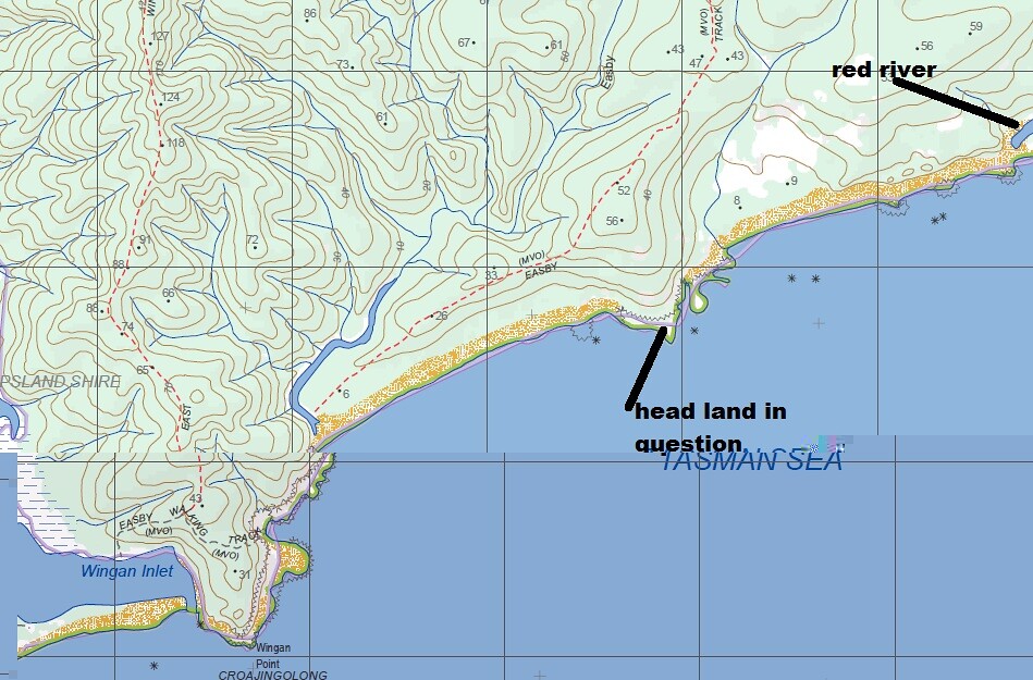 wingan
 by
boo 53, on Flickr
Its this one I was hoping there was an easier way around
(I uploaded in photobucket the 1st time but only part of the map showed up. In Flickr you can only see part of the map here but if you click on it the whole image is visible
Re: Sandpatch Wilderness Area, Croajingalong NP
Posted:
Thu 22 Sep, 2011 3:54 pmby MartyGwynne
Oh that one....
Funny how the bad bits get lost in memory.
I remember walking just in the trees at the top of the rocks as there is a little bit of a foot pad there.
I am sure it only took about 2 hrs to get from Wingan to Red River, maybe a little more but not that long.
Hope that helps JC.
Marty
Re: Sandpatch Wilderness Area, Croajingalong NP
Posted:
Fri 23 Sep, 2011 7:49 pmby jcr_au
Thanks, yes thats exactly what I was after. The footpad wasn't there when I walked it. I did try to push around there but the scrub was too tough. It was up and down large boulders when I did it, well over 1 hr just for that headland.
I've dug the inflatable boat out of the shed to make sure its still ok to use it Wingan, so looking forward to it now.

Re: Sandpatch Wilderness Area, Croajingalong NP
Posted:
Sun 25 Sep, 2011 8:49 pmby MartyGwynne
It was not much of a footpad but certainly made better going along part of it, you still have to hop the rocks a bit but i always think that the higher up you are the easier it is.
Let me know how you go, I think last time I was there was when the avatar photo of me was taken which does show me hopping the rocks some 4 or so years back on that head land!
Another trip I have to do again maybe I will this Jan/Feb.
Re: Sandpatch Wilderness Area, Croajingalong NP
Posted:
Thu 29 Sep, 2011 9:29 pmby SteveJ
Hard to find fresh water at that time of year and the ticks and snakes are full on
Re: Sandpatch Wilderness Area, Croajingalong NP
Posted:
Mon 03 Oct, 2011 4:57 pmby jcr_au
Actually, when I did it last time was January and some people I walked with the last few K's into Shipwreck creek said they'd had some issues with ticks but I'd (read my wife) had liberally treated all my clothes with permethryn and I'd used deet spray where clothing didn't cover & I had no issues at all.
I used the vic mountain tramping club map as well as a vic topo and the club map showed water points. I only tried the one where the track came down onto the beach about 1 km before benedore river and there was good water there in a small waterfall in January in the middle of the drought, so thats not an issue either.
Snakes, well they're everywhere, but if we're just going in to Red River and back we should be on the beach except for THAT headland.
Re: Sandpatch Wilderness Area, Croajingalong NP
Posted:
Tue 04 Oct, 2011 6:16 pmby Bushman Ben
Ticks!? I am thinking of walking from Malacoota to Thurra in the early new year; i.e. first week in 2012, can anybody suggest anything that I should avoid? I was going to do the walk outlined roughly here:
http://walksaustralia.com/pages/croanji ... notes.htmlI generally wear gaiters, and I have good habits for walking (long-time hiker in snake country) and certainly would be very careful along the coast at that time of year, but what kind of preventative measures do I need to take against Ticks? this isn't something I have really had experience with. Obviously there is bug repellent, and permethryn (thanks for those Jcr_au) but are there any others you could suggest or is this pretty sure-fire?
Re: Sandpatch Wilderness Area, Croajingalong NP
Posted:
Fri 07 Oct, 2011 2:30 pmby phan_TOM
Being someone who has grown up with and had many ticks the best advice i can give is to check for them on a regular basis, maybe at lunch time and again once you're settled at camp in the afternoon. They will attach anywhere but prefer around your hairline, back of neck, armpits, groin etc. You should never scratch at them or try to scratch them out, it just annoys them into pumping more venom into you, its best to take a pair of tweezers or one of those specialised tick pulling devices and pull them out quickly and all in one go. If your not careful you can leave the head behind and this lets them get more venom into you...
http://www.otom.com/how-to-remove-a-tick - one of the tick removal tools, I'm sure theres a choice of different ones if you look around but I find a good pair of tweezers work just as well.
some people will have a bad reaction to a tick bitetoo, you can look up lyme disease and anaphylaxis to find out more, could be worhtwhile if you havent had one before and going somewhere where you're likely to get at least one
Re: Sandpatch Wilderness Area, Croajingalong NP
Posted:
Sun 09 Oct, 2011 10:27 pmby SteveJ
The place is filthy with ticks and snakes if you can't handle either then it is not a place to visit. The ticks carry all kinds of nasties too.
Re: Sandpatch Wilderness Area, Croajingalong NP
Posted:
Fri 18 Nov, 2011 11:40 pmby jcr_au
Just an update
We didn't end up getting to red river. We did get to seal creek one day, but the forecast for the next, which was when we were going to do that bit, was for thunderstorms and heavy rain so thought better of it & figure we'd start the drive home.
It turned out that next day was heavily overcast but very little rain. Damn. But we did then spend 2 days doing day walks in the Cape Conran Coastal Park which was very pleasant.
On the way in to Seal creek we came upon this fellow, who was well over 2m. There was a red bellied black near Dock Inlet in Cape Conran as well but he didn't stay to have his photo taken
