Snowy South

Trip reports, stories, track notes. Multiple/large photos are OK in this forum.
Forum rules
Posting large/multiple images in this forum is OK. Please start topic titles with the name of the location or track.

For topics focussed on photos rather than the trip, please consider posting in the 'Gallery' forum instead.

This forum is for posting information about trips you have done, not for requesting information about a track or area.

Snowy South

Postby biggbird » Tue 16 Apr, 2013 1:23 pm

Hi all, been a while since I've posted a trip report!

My partner and I were lucky enough to get to the top of Snowy South a couple of weekends ago, marking our 24th Abel. Still a ways to go there...

After a slightly confusing drive to the start of the Lake Skinner track, which I'm sure we made harder than it had to be, we started walking at around 10:30am. The walk from the carpark to Lake Skinner is a beautiful, relatively gradual uphill climb through fantastic, albeit slippery, rainforest. After reaching the end of the rainforest in around an hour, we continued on through the now more open forest, sloshing through the creek that seemed to have claimed the track until arriving at Lake Skinner around 1.5 hours after setting out from the car. As promised in the Abels, there was a large boulder with an overhang under which we could shelter, which was welcomed when it began to drizzle! The weather thus far hadn't quite been promising, with quite a bit of cloud about and plenty of wind, but had thankfully held up with anything too nasty.

After a brief stop for some lunch and photos at Lake Skinner, we crossed the outlet creek and headed onwards and upwards. I won't give away too many details, as I believe this is technically an off-track area, but the track was relatively easy to follow, if quite steep and slippery in places. We lost it at one point, about halfway up, though I think this must have been at one of the rocks which one has to ascend, with the continuation of the track above not immediately apparent. So we wandered around for a few minutes, becoming increasingly convinced that we had gone wrong somewhere, before turning around and rejoining the path somewhere above where we lost it. It really was a beautiful climb, past Pandanis and over rocks, with the clouds and mist adding a real sense of atmosphere.

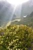
Once the steep climb from the lake to the plateau has been made, taking us around 30 minutes, one can look forward to some lovely walking across a beautiful alpine plateau dotted everywhere by Pandani, Pineapple Grass and Cushion Plants. The track takes a meandering route across the plateau, passing close to a strange little gully about halfway across, as well as a number of small tarns. As soon as you reach the plateau, pleasant views of the rest of the range to the North become apparent.

After 30 minutes or so spent crossing the plateau, we arrived at the boulder field which gives access to the summit. What had previously been a relatively well cairned route now seemed to have petered out, and we were more or less left to our own devices. It's entirely possible that I simply missed the next cairn in the string, but I doubt it would make a significant difference regardless, as one patch of boulders is often much like any other! We opted to continue further to the along to the west to what looked like an easier approach, eventually tackling the final approach from what I supposed to be the Northwest. The climb to the summit was certainly the longest and most taxing section of the walk, taking a solid hour from the Pineapple Grass at the bottom of the field to our eventual emergence at the summit.

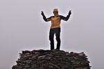
Whilst the summit may not have been terribly exciting in itself, the views we managed with the clouds politely parted were more than enough to make the last hour's tough walking worth it. Shaky arms and sore, stretched out groins were rested while taking in expansive views of the peaks of SW Tas, including The Arthurs (Eastern and Western), Mt Anne prominent in the foreground, Precipitous Bluff to the South and Mt Field to the North. The summit also gave a good view of the saddle between Snowy South and Nevada Peak, which looked like relatively open going, making for what I would imagine as a potentially pleasant 1 or 2 night traverse of the range as a whole.

Having been lucky with the weather to this point, outside of a shower or two and a whole heap of wind, we copped a decent smattering of snow on the way back. Not enough to seriously impair visibility, or at least not for long, the snow showers did make for some interesting boulder hopping on the way down. We elected to take a more direct route towards the plateau in view of the weather coming in, which happened to take us precariously close to a few 3m+ drops between boulders. None of it was really very hairy at all, with plenty of handholds and footholds, but just enough to remind you that you didn't want to fall! It was all fairly smooth sailing after descending from the boulder field, making it back to the car at around 6pm. We were gone longer than expected, having estimated somwhere around 6-6.5 hours, but given our interesting choice of routes across the boulder field, our time probably wasn't too unreasonable. I'd think 6-9 hours a reasonable range, depending on fitness, experience and weather.

Anyhow, after delivering you that nice little wall of text, probably an appropriate time for some photos:

The view across the plateau towards the Nevada Peak ridgeline and Snowy North
Image

A well earned rest at the top, looking North across the range to Nevada Peak
Image

The plateau was home to numerous Pandani, among others
Image

Lovely, open walking across the plateau, with the weather pretending to be kind... It was only a break between snow showers.
Image

Beginning the descent from the plateau towards Lake Skinner
Image

It was a steep and at times slippery ascent, making for just as steep and even more slippery of a descent
Image

Snow coming in over Lake Skinner
Image

In summary, it was a beautiful walk, and one well worth doing! A little effort required to navigate the boulder field, but nothing to trouble somebody without an obscene fear of heights. 24th Abel ticked off and would happily do it again. Thanks for looking :)
biggbird
Phyllocladus aspleniifolius
 
Posts: 763
Joined: Wed 25 Apr, 2012 10:43 am
Region: Tasmania
Gender: Male

Re: Snowy South

Postby tibboh » Tue 16 Apr, 2013 3:47 pm

Thanks for the nice report....brought back some nice memories.
I last did Snowy Sth in Dec last year and had better weather than you from the sounds of it. The acres of soft-underfoot pineapple grass were a pleasant surprise for me, more so than the pretty unimpressive summit. The views though, more than made up for it I agree. I would recommend this walk for early summer for one reason alone, the beautiful warratahs in bloom on the climb up from Lake Skinner.
DSC_6472.JPG
"I'd rather be up a mountain"
User avatar
tibboh
Athrotaxis selaginoides
 
Posts: 1305
Joined: Sat 26 Jan, 2013 3:54 pm
Region: Tasmania
Gender: Male

Re: Snowy South

Postby stepbystep » Tue 16 Apr, 2013 4:50 pm

When I was last there I noticed some Fagus on the shore of Skinner, would be nice right now I'd think. It is an excellent walk as is it's neighbour Nevada.

Thanks for the report bigbird.
The idea of wilderness needs no defense, it only needs defenders ~ Edward Abbey
User avatar
stepbystep
Lagarostrobos franklinii
 
Posts: 7625
Joined: Tue 19 May, 2009 10:19 am
Location: Street urchin
Region: Tasmania
Gender: Male

Re: Snowy South

Postby north-north-west » Tue 16 Apr, 2013 7:10 pm

Hmmmm, I did Snowy South via Nevada (a lovely little mountain, that) from a basecamp at Snowdrift, but the Skinner route sounds like fun. Have to go that way one day.

btw, there's a very obvious cairned pad that runs up to the summit tower from the ridge above Skinner. I bumped into it while summitting. The cairns seemed to lead all the way down, although I didn't follow them very far back. Rockhopping all the way to the summit would be very hard slow work.
"Mit der Dummheit kämpfen Götter selbst vergebens."
User avatar
north-north-west
Lagarostrobos franklinii
 
Posts: 15493
Joined: Thu 14 May, 2009 7:36 pm
Location: The Asylum
ASSOCIATED ORGANISATIONS: Social Misfits Anonymous
Region: Tasmania

Re: Snowy South

Postby biggbird » Wed 17 Apr, 2013 7:30 am

Thanks all for the comments!

Haha yes, rockhopping to the top was definitely slow and arduous, but we got there in the end! Depending on time available, work schedules etc, might see if we can manage to do an overnighter on the range in a couple of weekends' time.

As for the Fagus SBS, we saw a few bushes about, but not a great deal of Autumn colour as yet. Heading to Mt Field next Thursday, so fingers crossed for some more luck there. For someone who has lived in Tasmania all their life, I really haven't seen that much Fagus in its Autumn glory!

That's a lovely shot of the Waratah Tibboh, and I can see how that would definitely add to the experience. Longer days and a better chance of good weather would be nice too, so perhaps it will have to be walked again in Summer :P. The Pineapple Grass was much nicer to walk over than the rocks, but I always feel terrible when walking across anything like that!
biggbird
Phyllocladus aspleniifolius
 
Posts: 763
Joined: Wed 25 Apr, 2012 10:43 am
Region: Tasmania
Gender: Male

Re: Snowy South

Postby tibboh » Wed 17 Apr, 2013 12:53 pm

biggbird wrote:Thanks all for the comments!

The Pineapple Grass was much nicer to walk over than the rocks, but I always feel terrible when walking across anything like that!


Correct me if I'm wrong anybody, but I'm pretty sure the pineapple grass is a very hardy customer and would not suffer too much if you step on it. I as a rule I also try to land on rock or track rather than vegetation. Sometimes however you just can't easily avoid it as you can see below!!
DSC_6540.JPG
"I'd rather be up a mountain"
User avatar
tibboh
Athrotaxis selaginoides
 
Posts: 1305
Joined: Sat 26 Jan, 2013 3:54 pm
Region: Tasmania
Gender: Male

Re: Snowy South

Postby tigercat » Wed 17 Apr, 2013 3:29 pm

The summit boulders must have been slippery in snow.
Wilderness: restful and healing for the mind and spirit
User avatar
tigercat
Athrotaxis selaginoides
 
Posts: 1338
Joined: Thu 29 Mar, 2012 8:21 pm
Region: Tasmania

Re: Snowy South

Postby creeping_moses » Sat 18 May, 2013 12:53 pm

Nice trip, bigbird.

When I was last in here we went the same route as you and camped at the largest group of tarns below Snowy South. We were lucky to enjoy some of the best night sky views I've ever had while camping there; we saw many shooting stars! After this first night we walked from there to Nevada Peak, and onto Snowy North (via Wetpants Peak and Scriveners Cone) and back the same day. It was great going through to Wetpants but got very scrubby after that. Was a long day!
User avatar
creeping_moses
Athrotaxis cupressoides
 
Posts: 272
Joined: Wed 18 May, 2011 9:43 am
Region: Tasmania
Gender: Male

Re: Snowy South

Postby bluewombat » Sun 19 May, 2013 5:12 pm

Hi creeping moses, how was the section between Nevada and Snowy north. Was that scrubby too. Estimated time for that section one way?
bw
Even a long life is short
HPB
User avatar
bluewombat
Athrotaxis cupressoides
 
Posts: 366
Joined: Sun 10 Feb, 2008 3:55 pm
Region: Tasmania

Re: Snowy South

Postby creeping_moses » Sun 19 May, 2013 5:34 pm

Bluewombat: In general, from Nevada to Wetpants its open. If memory is accurate, It gets scrubby very quickly after that and with poor routes, can be a total scrub fight. Picking your line up Snowy North is important as we found there to be many patches of really thick scrub and some not so bad parts. In summer, water is hard to find after Nevada. I think we took about 5 hours from Nevada to Snowy North. Perhaps a little more. We got from Snowy South to Snowy North and back in a full summers day of light. Leaving as the sun came up and returning as it went down.
User avatar
creeping_moses
Athrotaxis cupressoides
 
Posts: 272
Joined: Wed 18 May, 2011 9:43 am
Region: Tasmania
Gender: Male

Re: Snowy South

Postby north-north-west » Tue 21 May, 2013 8:32 pm

creeping_moses wrote:Bluewombat: In general, from Nevada to Wetpants its open. If memory is accurate, It gets scrubby very quickly after that and with poor routes, can be a total scrub fight. Picking your line up Snowy North is important as we found there to be many patches of really thick scrub and some not so bad parts.

The annoying thing is that there are relatively open lines on each side of each intervening lump, but they don't connect - you have to keep dodging left or right on each ridge top to join them. That got old very quickly.
Good walk otherwise.
"Mit der Dummheit kämpfen Götter selbst vergebens."
User avatar
north-north-west
Lagarostrobos franklinii
 
Posts: 15493
Joined: Thu 14 May, 2009 7:36 pm
Location: The Asylum
ASSOCIATED ORGANISATIONS: Social Misfits Anonymous
Region: Tasmania

Re: Snowy South

Postby creeping_moses » Tue 21 May, 2013 8:39 pm

Indeed, NNW.
It's not an easy ridge to walk by any measure.
User avatar
creeping_moses
Athrotaxis cupressoides
 
Posts: 272
Joined: Wed 18 May, 2011 9:43 am
Region: Tasmania
Gender: Male

Re: Snowy South

Postby PeterJ » Wed 22 May, 2013 8:09 pm

creeping_moses wrote:..It's not an easy ridge to walk by any measure.


When I read “creeping_moses” times and conditions from Nevada to Snowy North, I thought my memory of it was a bit easier. However after looking back at my records I realised my memory had faded. It took 4:15 hours from Snowdrift Trans to Snowy North and the report below from “SueoftheSouth” confirms that it was harder and scrubbier than my memory too.

We left camp with daypacks to tackle Snowy North. It was across the plateau, down to the base of Wetpants Peak and then over the top and down the other side. There were quite a few boulders at times making progress quite slow. Then onto Scrivens Cone and down the other side, followed by the plateau walk toward Snowy North, where the plant growth made the going tiring with the ups & downs. It was noon when we stopped at the end of the plateau with Snowy North still looking quite a distance away. Lyn & Clive were turning back so I decided to do the same, as the day would have been pretty long in the hot weather. Walking back was rather hot and we were pleased to be back at the tent around 3.00pm for a cuppa. It was 3 hours later that the others returned, they were very tired and thirsty and said they had struck quite a bit of scrub after leaving us, so we had made the right decision
User avatar
PeterJ
Athrotaxis cupressoides
 
Posts: 428
Joined: Mon 24 Sep, 2007 5:06 pm
Location: Lenah Valley
Region: Tasmania
Gender: Male

Re: Snowy South

Postby north-north-west » Thu 23 May, 2013 6:19 pm

Yeah, I think it took me something like four hours (which was less than I expected), including going over Wetpants and Scrivens on the way up. Return was a similar time despite sidling them on the way back, thanks to tiredness. Although there was enough time for a quick dash up Nevada before din-dins. I like that mountain. :)
"Mit der Dummheit kämpfen Götter selbst vergebens."
User avatar
north-north-west
Lagarostrobos franklinii
 
Posts: 15493
Joined: Thu 14 May, 2009 7:36 pm
Location: The Asylum
ASSOCIATED ORGANISATIONS: Social Misfits Anonymous
Region: Tasmania


Return to TAS Trip Reports & Track Notes

Who is online

Users browsing this forum: No registered users and 4 guests