My young adult son and I planned to spend 7 days walking through the Walls of Jerusalem and immediate surrounds, flying down from Sydney straight after Christmas. We stayed a night in a Launceston hotel before and after the trip, and arranged commercial transport to and from the Walls. Our rough itinerary was to spend time at:
• Wild Dog Creek (2 nights) and explore around the Central Walls area
• Lake Ball or Adelaide (1 night)
• Lake Meston (1-2 nights)
• Junction Lake (1 night or as a side trip from Meston)
• Lake Myrtle (1 night) then exit back down to the Mersey Forest Rd to meet pre-arranged transport
We aimed to be flexible, to allow for weather and so on. What follows is a detailed account of the way that things actually worked out.
Saturday 27/12/08
After flying in to Launceston around 2230 on Boxing Day and spending the night, we enjoyed a hot breakfast at our hotel and were waiting outside by 0830 for transport to the Walls of Jerusalem. We managed to share transport costs with three parties doing the Overland Track, so we had to go to Cradle Mountain with them first. We picked them up from various hotels. One OT lady was going solo after her husband became ill at the last minute and had to cancel. She was a bit apprehensive and I reassured her that she would likely find company on that trip. We stopped at Deloraine for coffee and cake. Picked up some up fresh food for lunch knowing we'd be living on freeze dried meals etc for the next week or so. Got our parks passes at Cradle while the OT participants were unloading. We enjoyed the drive down to WOJ with our driver, an experienced Tassie bushwalker and outdoor activities instructor. He gave us some tips on a couple of out of the way camp sites in case Wild Dog Creek was full.
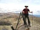
On arrival at the Walls around 1400 the car park was almost full. One group was preparing to start their trip and another was finishing. The weather was fine and quite warm. I didn’t see any signs of vandalism to vehicles. I made sure that we got the two gas canisters and matches I'd arranged. We bade farewell and started up the steep track to Trappers Hut, stopping there for a brief rest and photos. We passed several parties of day trippers who were coming down. I got the impression that the Walls could be busy. They were.
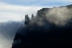
Near the Lake Adelaide/Junction Lake turnoff we spotted an Echidna on a large rock next to the track. It kept us amused while we took photos of it feasting on ants in the cracks and crevices. The balmy weather continued as the splendid Solomons Jewels came into view and we again stopped for photos. A party of four young blokes asked us to photograph them. I noticed that they then drank water directly from the lake, so I guess it’s presumed clean. We arrived at Wild Dog Creek half expecting it to be full. To our surprise almost the entire lower level of platforms was empty, although further up the hill was much busier. We grabbed a vacant platform at the bottom. It’s more exposed there but has a nice view. It took a little while to work out t how to pitch our non-freestanding WE Second Arrow using wires, rocks and guy ropes. The water available to the tent sites here is excellent. Unfortunately we chose a spot that almost required a short day walk to reach the loo. However it was still handy, particularly in the rain. The initial plan was to spend two nights here, allowing us a full day of exploring around the central Walls. In a fit paranoia I decided that I had somehow wasted half a gas canister cooking dinner. This eventually proved untrue but I was very economical with gas from then on.
Sunday 28/12/08
We woke to find that the wonderful weather had gone. It had been replaced with rain and wind. We lingered over breakfast hoping that it might improve. When it became clear that this wasn’t happening we donned wet weather gear and daypacks anyway. We set off up the track through Herods Gate with a vague plan to visit Dixons Kingdom, hopeful of improved weather. It was blustery and raining, the peaks were invisible so it was pointless going up them. Called in to the Pool of Bethesda, which looked quite magical in the rain and mist. Moving on to Dixons Kingdom hut we passed several parties heading back towards Wild Dog Ck. The Walls were very busy around this general area the whole time we were there. The hut was empty, briefly. A saturated young Canadian came in from a tent nearby and started stripping off his wet gear, saying that it was easier to pack up there than in the tent, as they were about to head back down via Lake Adelaide. We thought about having lunch when a party of six arrived looking very wet. They’d taken the deviation from Trappers hut and had camped somewhere in the Wild Dog Creek Valley, and were planning to eventually join the OT via the Never Never. They seemed a little unclear about the route so I lent them my Mersey map. The Canadian’s companion arrived and the hut was now very full. I was grateful when everyone left and we had some space for lunch and to plan our next move. We decided to walk down Jaffa Vale as we would be going that way eventually and might as well find the route through there now with light day packs. A family of day hikers soon arrived followed by a couple asking questions about tracks in the area. Not that I’m the best qualified person to answer; I must look knowledgeable or something. We didn’t have much difficulty getting down to Lake Ball and found the marked track that continues from there. It was still raining. We started back and found a better route that skirted the pencil pine forest. I’m curious as to why there’s a remote area log book in an obscure spot in Jaffa Vale?
The weather started to clear a bit as we returned to Dixons Kingdom. We met another party at the hut who asked about camping there. As we chatted the weather improved markedly and we spontaneously decided to climb Mt Jerusalem. The climb is steep but not difficult. In fact I think it’s probably one of the easiest climbs I’ve done up a Tasmanian peak (of the handful that I’ve done). The summit was very blustery and the weather threatening but we enjoyed some brief sunshine and great views over the Walls and the many lakes of the Central Plateau. We descended in deteriorating weather and paused for photos at several pretty tarns and a Scoparia “garden”. The party we spoke to earlier were now camped some way uphill from the hut with two other tents. We started back to Wild Dog Creek and noticed a group coming down from Solomons Throne. We paused to decide if we should go up but it was now getting late and the weather worsening, with the tops staring to white out again. We decided against it.
Monday 29/12/08
Woke to poor weather again and delayed doing anything to see if it would improve. That clearly wasn’t going to happen so we planned a lunchtime departure for Lake Ball. Again travelled via Dixons Kingdom where a lady insisted on taking our photo as we were now carrying full packs and wearing tarp ponchos to combat the rain. She was amused by these and wanted to know where to buy one. We quickly proceeded down Jaffa Vale and on to Lake Ball Hut.
We decided to stay in the hut that night. It was empty and the wind and rain turned us off camping on the small promontory nearby, which looked very wet and boggy. The hut has no insulation and is very breezy. I used a large garden waste bag to insulate part of the wall beside my sleeping spot. This blocked out much of the cold breeze coming through the gaps. The hut was more comfortable than it looks and we weren’t cold. I’d read about a troublesome possum here so wasn’t surprised to find an enormous brush tail lurking outside the door when I went to collect water for dinner. In a loud voice I asked it to leave but wasn’t convinced that would happen. We kept all food secure but the possum didn’t return during the night.
Tuesday 30/12/08
We had now become used to waking to wet, cold conditions. A sodden party stopped briefly at the hut as we packed up. We headed up the initially steep and rocky route around Lake Ball which soon became much easier. I was a little surprised not to spot any fishermen around any of the lakes on this trip. The weather became intermittently sunny, windy and raining. We were able to stop for photos during the fine patches. Small tarns, Scoparia, cushion plants and a “rock garden” towards the western end of the lake were impressive. We dropped down the short, steep descent to Lake Adelaide.
Wildflowers became abundant as we travelled the length of Lake Adelaide. It climbs up and down like a goat track in some places through here, but overall is not too bad. We attempted to stop for lunch but it bucketed down and we had to abandon the idea, as there’s no real shelter anywhere. We eventually did stop to eat at the pleasant camping area at the southern end of the lake. From there it was wet, wet, wet as we passed through the boggy plain towards Lake Meston. I managed to plant one leg in a bog hole up to the top of my gaiter. To even up the score the other leg found a similar hole a few hundred metres later. We passed through a marshy but picturesque small valley before arriving at the northern end of Lake Meston.
The view from the large campsite here is spectacular, looking over the lake and towards the Mountains of Jupiter. So we decided this would be our base for the next two nights. This location is quite exposed so we made the tent secure and set up our tarp ponchos as an eating and gear storage/drying shelter. The wind started to rise and the rain returned. Overnight the wind became so violent that I was convinced we would be blown off the planet. From the amount of flapping going on I expected that all the guy ropes had come adrift and the tarp poncho shelter long since taken off into the heavens.
Wednesday 31/12/08
Around 0600 my son Andrew peered out of the tent. His voice of disbelief announced that it was snowing. The ground was covered in a good dusting and it was still falling. However the tent, all guy ropes and the shelter were intact and fully secure (thank you WE/STS). The snow eventually cleared and the day produced more strong winds interspersed with rain, and some relatively calm sunny breaks. These gave us a chance for unhindered photography and exploring around the immediate area. After lunch we decided to attempt a quick trip down to Junction Lake and back. After about half an hour we arrived at Meston Hut, so stopped for photos and wrote in the log book. Spotted what we assumed to be the track to Lake Myrtle opposite the door, and noted this for future reference.
We proceeded south towards Junction Lake, passing through initially rocky terrain and crossing a number of small fast flowing creeks. Then on to light open forest on a good track to Lake Youd and Mayfield Flats. We then had some navigation problems but eventually found the correct, though vague, route. We were now less than a kilometre from Junction Lake. However it was getting late and it looked like a snow storm was approaching. We took the safe option and turned back, to give us enough time for a return to camp in daylight and hopefully remain relatively dry. We’d earlier crossed a fast flowing side creek running down from Mt Rogoona. So we used it to replenish our water supply.
Returned to find the campsite invaded by a single party of ten spread across five tents camped only a few metres away. They were friendly but noisy. Their presence removed the splendid solitude we’d enjoyed for the previous 24 hours or so. During dinner it appeared that the wild weather was returning so we retired to the tent to read. I put on the headphones of my MP3 player to drown out the noise from the New Years revellers next door, but they eventually went to bed. The wind had eased from the previous night.
Thursday 1/1/09
We again woke to rain but no snow…yet. The masses left early and we decided to give them a long head start, wherever they were going. We packed up and started for Lake Myrtle. We’d planned that to be the final night’s camp, as transport was arranged to collect us around 1400 tomorrow.
We had lunch at Meston Hut, again noting the track opposite. We attempted to follow it, for a short time. However it seemed to disappear into nothing so we backtracked and tried other “tracks” leading off it with the same result. Where did it go? The track notes I had seemed to indicate that this should be it. However we were wasting a lot of time and the weather was starting to deteriorate again. We knew which direction that we should head and decided to press on; albeit off track. Using compass, map and dead reckoning we scrub-bashed and scrambled upwards. It suddenly starts snowing heavily, the wind is picking up, blowing snow into our faces and it’s becoming hard to see.
We’re now committed, so push on determinedly following a creek, crossing and re-crossing it. Occasionally we find cairns which are partially helpful (at least others have been this way before) but also confusing (so where is the track?). We thought that we heard voices nearby a couple of times, but saw no one and a few cooees didn’t elicit a response. We finally arrived at a high point and there was a lull in the snowstorm. We could clearly identify Lakes Myrtle and Louisa among others. We were heading more or less in the right direction but had actually climbed a good way up Mt Rogoona to just beyond a saddle. We now had to find a way down by sight and instinct, again off track. After much scrub bashing and route finding we finally arrived at Lake Myrtle, which was a quagmire on this particular day.
It was snowing again and we were starting to get quite wet and cold. We still couldn't locate the track but knew it was close by. We meet a party of day walkers, only metres away, who are actually on it. Groan. We jump into the creek separating us. Boots are already wet through, so it matters little. Nothing around Lake Myrtle is now visible through the snow, rain and wind.
We immediately decide to push on to Lake Bill in case the weather doesn't clear, or becomes worse. Can that happen? Probably. The weather briefly improves, but at Lake Bill it starts to snow yet again. We are now wet, tired and cold, and need to warm up. We hurriedly set up camp not far from the track. Once inside the tent, in dry gear, it is surprisingly warm and comfortable. I couldn't be bothered cooking and it's snowing outside anyway. We enjoyed beef jerky and biscuits for dinner. I read briefly then listened to MP3 music and fell asleep.
Friday 2/1/09
Wake to find snow everywhere and it's still falling on and off. Snapped some photos of Lake Bill and Mt Rogoona. We ate breakfast and decided to get moving early. There’s plenty of time as our ride won't meet us before 1400, but the weather hasn’t improved. The thought of putting on wet boots and socks is unattractive but it has to be done.
Finally packed up and armed with gaiters and wet weather gear (again), we take more photos then set off across the now quite boggy Blizzard Plain. The walk across is wet but enjoyable and we stop several times for more photos. Turning around a snow storm seems to be chasing us across the plain. It arrives but is short-lived. We continue on through the button grass, following the sticks with pink ribbon on them, to the edge of plain where the track meets the descent to the Mersey Forest Rd. We take it slowly down the sometimes steep track. There’s no hurry. The ferns and lush foliage are a contrast to the plateau above. It's still wet but much calmer down here. We sign out at the log book near the end of the track.
Arriving at the car park and road we strip off wet boots, socks and gaiters and get into dry(er) camp shoes. It's still cold and blowy with occasional light rain. We put on tarp ponchos to block the wind and rain and have lunch while waiting. I wander down the road and quickly snap a photo of Mt Pelion East in the distance. It looks bleak and is snow-covered, and immediately becomes whited out. Our lift arrives on time and we return to the hotel in Launceston. We spend the rest of the afternoon trying to dry out as much gear as possible. Enjoyed a welcome hot shower followed by a nice meal and a beer in the restaurant. We conduct a post mortem of the trip over dinner.
Saturday 3/1/09
We left at 0540 for an early flight. The metal eyelets in our (still wet) boots set off the airport metal detector and we have to remove them. After two flights, train, bus and taxi we arrived back at home around lunch time 3/1/09. It was now sunny and about 22 degrees.

Echidna feeding on ants near Trappers Hut (and getting plenty of them). He wasn't bothered by our presence.

Solomons Jewels.

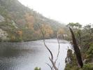
King Davids Peak/West Wall on the way in to Wild Dog Creek campsite. The weather had us fooled.

The ambience of the Pool Of Bethesda in the rain.

Reccy down to Lake Ball in the rain.

Solomons Throne from Jaffa Vale (well it's up there somewhere).

Many lakes and tarns from summit of Mt Jerusalem.

Summit of Mt Jerusalem looking north over Lakes Sidon and Thor etc.

Another from Mt Jerusalem looking back to central Walls area.

Tarn below Mt Jerusalem.

Scoparia near Dixons Kingdom.

Solomons Throne puts in an appearance.

Back to Wild Dog Creek.

Looking up to Herods Gate from Wild Dog Creek. The weather is no better, lets move on.

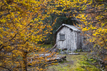
For a change of pace we stayed a night in the tiny and airy Lake Ball Hut.

Lake Ball.

Lake Ball West.

Small Tarn and Cushion Plants - Lake Ball.

Cushion Plants.

Approaching Lake Adelaide.

Marshy but very pretty valley between Lake Adelaide and Lake Meston.

Snowy view from the tent early New Years Eve 2008 - Lake Meston North.

Mountains of Jupiter from Lake Meston.

Blustery conditions at Lake Meston.

Maybe the weather will clear?

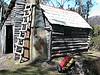
Lake Meston Hut with a couple of unscrupulous looking characters.

Lake Youd.

Scoparia field on Junction Lake track near Lake Youd.

Lake Myrtle and Mt Rogoona New Years Day 2009.

Early morning tent view Lake Bill 2nd January 2009.

Snowy forest around Lake Bill.

Still plenty of snow lying around Lake Bill.

Lake Bill and Mt Rogoona.

The weather chases us across Blizzard Plain.

Button Grass tarn on Blizzard Plain.

Zooming across to Mt Pelion East from Mersey Forest Rd. I walked down the road a bit while waiting for our transport to arrive. From a gap in the trees I managed to snap this just before it became completely whited out. I wonder how the people on the Overland Track were faring.