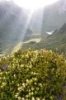
Anyway, I had to park my poor Magna (lowered with sports suspension) halfway up the forestry track, with a 10-15 minute walk to the Gnomon carpark, as it just wasn't coping with the track!! I get to the Gnomon carpark, and couldn't understand the diagonal arrows on the sign, so went down another forestry track for a further 10-15 minutes, where I came to a sign going left for Mt Gnomon and right for Tall Trees Track. So I'm guessing I took the Tall Trees route to the top of Mt Gnomon? Upon coming back down (after reaching the top!) the same way I entered, I realised that there looks to be another entrance.. So is this track on the far left the actual Gnomon track? Pic below..

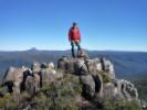
Anyway, on top of Mt Gnomon, I met a local guy who works at an outdoor store who actually served me a few weeks ago!! Small world! Due to my obviously neglected navgation skills, I was going to end the walk with Mt Gnomon. But he assured me Mt Duncan is easier, and because I was unsure about taking the Tall Trees route to Duncan, he suggested to follow the forestry road by foot to come out at the start of the Duncan track. So off I went. 30 minute walk from the Gnomon carpark to the bottom of Duncan, and I headed off up Duncan. Easier my backside!! Both tracks were quite overgrown, but this one (must be from the rain yesterday) was very slippery up the top ten minutes!! But, I got there (the rope helped too! I remember someone on here said it was useless! Damn my short legs!!) and it was beautiful! Is this the trig point of Duncan? Pic below..

So all up it took me around 6 hours, with half hour on top of each to enjoy the view and have a snack!! My favourite moment of the day was seeing my beloved Mt Roland off in the distance of both peaks
Dodgy zoom pic below!!

Thanks to everyone yesterday who replied on my information post!! I loved every bit of it
PS: For those wondering, yes the road is open all the way to Duncan, but definitely needs a 4WD!!