Statistics:
Start Weight: 63.5kg
Finish Weight: 62kg
Start Pack Weight: 38-40kg
Finish Pack Weight: 21.5 kg
Days Spent: 22 days
Days Spent in Tent: 5 days
Days Food Carried: 27 days
Food Carried: 20x Breakfast, 20x Dinner, 20x Lunch, 60x Energy Bars,
15x Misc Dehydrated Fruit, 1kg Chia Seeds (18-20kg)
Food Given to Me: 2 x Lamb Dinner, Dehydrated Rice, Pack of Chapati,
2x 18g Mars Bars, 2x 40g Protein Bars, 1/2 Cucumber,
3x Tea Bags, 100g Salmon, Small Bag Trail Mix,
1/4 Caramel Chocolate Bar, 3 Oreos, 1 Apricot Chew, Tape,
Ink Pen
Food Given Away: 2x Lunch, Berries/Apricots, Fruit Straps, 7x Energy Bars,
4x Dinners
Route:
February 17 - March 10, 2015
Days Before

One month of work & twenty days of food on one table
Ah and on a side note the raw energy bars we made are amazing! One 80g bar has 1550kJ (330cal), 11g protein, 19g fat, 34g carbs, and 16g fiber/sodium!!! My target kJ per day is 16,000kj.

Beautiful jungle energy everywhere we go smile emoticon Thank you so much for the lift from the airport, bringing me to cygnet, and on to the ferry to bruny island. Love and light Celine

A Dutch Eye. One of the beautiful girls whom picked me up upon arriving on Bruny Island, such a rough life
Day 0 : Hitch Bruny Island to Hobart. Stay with friend from forum.

Hitching across "the neck" on Bruny Island
Day 1: Leave Hobart 7:30AM. Arrive at Scotts Peak 12:30pm. Walk to Junction Creek.

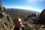
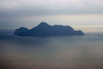
Just arrived hitching to Lake Peddar and get my first glimpse at the Arthur Mountains.
Day 2: Junction Creek up Moraine Alpha to Lake Fortuna. Take a wrong turn on the bluffs NE of Lake Fortuna. Descended into burnt vegetation, ripped tent bag, almost lost cooking pot. Nice introduction to what is to come.

The top of Moraine Alpha looking down on the Arthur Plains
Day 3: Lake Fortuna to Cygnus. Decide to stay in this area for another night. Rope food at Lake Cygnus in case of rats. Go back to Lake Fortuna to retrieve lost socks, go for a swim, and back to Lake Cygnus before sunset.

- Feeling free atop the range.
Day 4: Wake up to a cloudy landscape. Walk to Square Lake, camp on shelf above lake. Climb Procyon Peak for Sunset.

The trail below Mt. Hayes.

Intrigued by everything

Looking down on Lake Neptune

Early morning looking over Lake Cygnus

Looking down over the Arthur Plains

On the way to Lake Oberon straddling Mt. Hayes

Spires off of Mt. Hayes

Looking back at Mt. Hayes

Many of the days the Arthur mountains were shrouded in clouds whilst the Arthur Plains looked to be having perfect weather!


Camping on the shelf above Square Lake

Evening from Pyrocon Peak

Evening from Pyrocon Peak

Evening from the Pyrocon Peak

Evening from the Pyrocon Peak

Sunset from the Pyrocon Peak
Day 5: Walk to Lake Oberon. Spend much of the day atop Mt. Orion. Go for a swim. Relaxing day. Clear night, new moon, great for Astrophotography.

Looking back at Square Lake and the shelf I camped atop the night before.

Classic shot attempt at Lake Oberon

Dinner at Lake Oberon

Sunset at Lake Oberon

The Milky Way over Lake Oberon
Day 6: Clear Morning. Scary start up Mt. Pegasus with heavy pack. Go modular with pack to get through the rock squeeze. Almost descend wrong side of pegasus. Walk to High Moor by Sunset.

Lunch overlooking Lake Uranus

Looking back at the route over Mt. Pegasus and around Lake Uranus


The mirror of Lake Ariel

Sunset from High Moor
Day 7: Wake to high winds and rain. Wait out storm at High Moor until clear weather. Sun out for two hours in the evening.
Day 8: Wake to foggy morning. Shortly into the Beggary Bumps, descend wrong gully 100-200m before realizing it was the wrong direction. Traversed moss covered cliffs and came up the gully with a small rope across. Lost a few hours and felt exhausted. Rope bag before Haven Lake. Meet two other hikers, share dinner and stories. They give me 2x lamb dinners, 1 packet chapati, and half a chocolate bar.

Views from High Moor of Mt. Capricorn

Lake Saturn

The start of The Beggary Bumps

The start of The Beggary Bumps

Within The Beggary Bumps

This was the toughest moment during my trek within the Arthur Mountains. On day eight I traversed a section called the Beggary Bumps. That morning it was quite foggy and I became confused at where I was exactly. I ended up descending around 100-200m down an extremely steep gully in which I wasn't meant to go down. Considering the weight of my pack I didn't think I could climb back up. From there I risked climbing out onto steep moss-covered cliffs with dense vegetation to the point I could barely get through. Luckily I was able to take off my pack, climb up to find the trail, clear a path, and get back on track. I would rarely consider taking a selfie but I suppose I wanted to remember this moment. It was only 11am, yet I had already lost one contact lens, felt exhausted, spent, and quite scared to be honest. I think for the first time I realized I was alone, and how quickly things could turn bad within this environment if I rushed and didnt use the maps/track notes properly.

Lake Mimas and Mt.Shaula

Looking back over the gnarly as Beggary Bumps

Lake Haven

Nice to share dinner and stories with Andy and ??? So sorry I forget names so easily and thank you for the delicious Lamb and gravy dinners, chapati, and chocolate!!
Day 9: Walk to Promonotory Lake. Nice to have a different dinner, lamb and gravy over rice.
Day 10: Wake up high winds and rain. Walk to camping are North of Lake Venus. Spend day in tent during storms. Storms pass shortly before sunset.

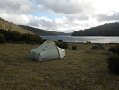
One of my favorite campsites above Lake Venus

Streams above Lake Venus

Sunset above Lake Venus
Day 11: Walk to Lake Rosanne. Rip pants in scrub. Cold night. Rain during the night.

Near West Portal looking back over the Western Arthurs

Near West Portal looking back over the Western Arthurs
Day 12: Wake to beautiful lenticular clouds. Storm hits while on Lucifer Ridge. Decide to take shelter for lunch under rock overhang. Clothes become wet after I decide to go back to Lake Rosanne for water. Build small fireplace once back and get a fire burning despite the rain. Dry most of my clothes and decide to spend the night on the ridge. Pitch tent uneven on top of button grass.

Awake to Lenticular Clouds. Realize now what a warning these are!
Day 13: Spend until 5pm sheltered from the rain in front of a small fire. Rain clears around 4:30 so I pack up and walk to Pass Creek. Pass Creek was flooded, decided to camp on the plains and let the water level drop.

A break in the storm
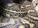
Day 14: Wake to clear skies. Dry gear and let water level drop. Walk to Stuart's Saddle. Almost step on large tiger snake while not wearing gaiters near Lake Leo. Meet two other hikers, share chocolate and stories. Learn of bad weather and possible snow next 3 days.

Awake webbed in on The Arthur Plains

Waking up on the Arthur Plains

Early morning views of the Arthur Plains

Sunset over Lake Leo

Mark and Jeremy. Two great guys I met at Stuarts Saddle. First people I had the gift of conversation with in almost 7 days! They shared the weather forecast with me letting me know the snowstorm and freezing rain was incoming for the next three days. They helped motivate me to continue on in hopes of waiting on the storm. They gave me food, and a much needed ink pen to continue writing in my journal
Day 15: Walk to Goon Moor in hopes of waiting out the storm.

Sunset over Federation Peak viewed from a ridgetop near Goon Moor.

Sunset looking west from Goon Moor over Bathurst Harbor

Sunset over Bathurst Harbor

Panoramic looking west towards Bathurst Harbor
Day 16: Storms at Goon Moor
Day 17: Storms at Goon Moor

Snow in Summer!!

Snow and Pandani
Day 18: Storms at Goon Moor

Sunset with Pandani and Scoparia from near Goon Moor within the Eastern Arthurs.

Sunset with Pandani and Scoparia

Pandani Sunset
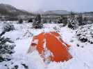
Day 19: Wake to high winds and rain, decide to go back. Walk to Pass Creek. Very wet upon arriving.
Day 20: Clear Weather, slight occasional rain. Walk to Seven-mile Creek.

The Arthur Plains

The road to mushrooms!
Day 21: Clear Weather, slight occasional rain. Walk to Junction Creek.
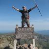
Day 22: Clear Weather, slight occasional rain. Walk out and catch a ride back to Hobart.

Rachel and Andrew - I met them at Junction Creek on Day 21. We walked out the next morning and they gave me a ride back to Hobart

Just me

My first meal. Amazing dirty pizza from La Bella in Hobart, Tasmania!
Days After

My last sunset in Australia

My last night in Hobart overlooking the city
Thoughts:
Most of the advice I was given should have been heeded, however I made due with the gear and weight that I had. My rain gear was not sufficient for this type of environment and my pack was extremely over weight for the first couple of weeks. Although having enough food to go slow was perfect for the time I wanted to spend. I should have had more than one change of clothing in case of getting wet. Having the gear strapped to the outisde of my pack caused a lot of rips and tears to everything. The food I carried turned out to work great although I will have more variety and less food next time. I planned to eat 15,000kj per day but this was impossible for me. My daily eating scedule was, breakfast, lunch, dinner, and 3 energy bars. I rarely could eat all the energy bars per day. Even with the food I gave away and the food given to me I estimate that I had enough food for 27 days. Also during this I was injury free. Never once had to use a band-aid or take any medication. I was also amazed that I lost practically no weight, less than 2kgs! My primary cooking fuel was Petrol, 1 liter, which lasted me 19 days. The Arthur Mountains were completely different than I anticipated. Although spending twenty two days within these mountains are one of the most amazing things that I have ever done. I feel like I learned more during this than any other trek I have attempted. I wish I could have attempted Federation Peak but I think it was wise I didn't push further in foul weather. I can always come back. After this I decided to come back home to the Appalachian Mountains, grab some new gear and head to New Zealand for a year January '16. Thank you to everyone who offered advice and suggestions while I was planning this. A huge thanks to biggbird for the hospitality, taking me rock climbing, and even driving me to the airport. Would love to payback the favor somewhere in the world, thank you both for being such amazing hosts! Also without biggbird I would have had no EPIRB or the sufficient maps I would have needed. I'm sure I left out a lot but here is my rough trip report. I apologize for the fire...If it wasn't out of necessity I would have not had one.
Love and light,
Jordan
http://www.facebook.com/wirednomads