Anyway, I left the visitors centre a bit before 10am, and it was already starting to get warm. 3 minutes into the walk, I saw my first snake of the trip – a large tiger slowly making its way across the wide track. I passed Watersmeet and began heading in a northerly direction up the lake. I wouldn’t say I raced along the shore of Lake St Clair, but it was nonetheless a quickish pace through some nice forest. I did forget how much the track undulates though, making it slightly harder work. It was an absolutely fantastic day. The breeze was light, and the small waves on the lakeside gently lapping against the rocks was a very soothing sound. It took me 2.5 hours to reach Echo Point Hut, where I sat down on the sandy beach, and enjoyed lunch.
- Echo Point
Onwards I went, counting the major creeks as I went. After 3 major creek crossings, I spotted a little waterfall upstream, plus a piece of tape up the slope. It was time to leave the Overland Track behind. I got my GPS out, and began the steep ascent. And boy was it steep! With a 17kg pack on, I was feeling it in the legs, that’s for sure! My progress was halted by an imposing wall of sandstone cliffs. I decide to explore a bit off to the right, and sure enough, came across a breach. It wasn’t going to be easy though. I didn’t bring any rope with me, and while there was tape marked (which alleviated any concerns about it being the wrong route), it did still look rather daunting. Someone had left a piece of rope tied into a loop which could act as a foothold near the base of the climb up, but I chose not to use it, in fear of getting my foot snagged. I took a few deep breaths, grabbed hold of the best placed roots, and went for it. My knee took my weight, as I heaved myself onto a mini ledge about one third of the way up. The next stretch looked even tougher though. It’s hard to explain, but I had to head left once I had reached this point instead of straight up, as slippery vegetation and a lack of handholds prevented me from making a beeline to the top. The handholds were harder to find here (for me anyway). I was starting to feel extremely nervous about the consequences of making a mistake here. But the determination to reach the summit was too strong. I just went for it. I lifted myself up another metre or so, and despite not having my feet in an ideal position, I quickly shifted my hands to a stronger, more comfortable position. This gave me the height I needed to place my foot in the cradle of two roots, and haul my body over the top and onto the leaf litter above. I’m pretty sure I just lay there on the ground for a few minutes, waiting for the nervous feelings in my stomach to fade away. Once they did, I continued on my steep upward trend, passing through two more line of cliffs where the tape was located. These next two were far easier though and I had no issues whatsoever.
- A rather poor photo of the tricky cliff
- cliff.JPG (102.97 KiB) Viewed 18605 times
The vegetation was becoming scrubbier and I had to a lot of ducking and weaving to avoid getting caught on low-lying branches. At times I came within metres of the creek, where some spectacular waterfalls were located. It was hard to photograph though, as they were bathed in sunlight. One final, small cliff awaited. It was barely a cliff to be honest, more just a steep scramble with no handholds, as the roots in the ground looked like they’d be ripped out of the ground if any weight was placed on them. Once that was negotiated, I began to veer away from the stream, and the tape petered out, leaving me amongst the scrub. It wasn’t too thick though, which I was pleasantly surprised about. There were some deep, dense patches, but these were easily avoided. I think the worst I found myself in was some knee deep scoparia and overhanging branches blocking the view ahead. My GPS did an excellent job in keeping me on a bearing for Lake Oenone, and I found myself on some pads, which helped avoid the scrub, but not the cobwebs!
- Taking a break on the climb up
I knew Lake Oenone was close, but every time I saw what appeared to be the top of a ridge, I was left disappointed. It was like coming to false summits in a way. As I walked, there were some outstanding views up to the southern part of My Olympus, and I could also catch glimpses of Mt Ida if I turned around. The scrub began to recede, and I found myself walking across open spongy grass, surrounded by native pines. It was a glorious place, and I eventually reached the shores of Lake Oenone, 2 hours after leaving the Overland Track. I took a well-deserved break in this phenomenal location. I was drenched in sweat, and a swim was extremely tempting, but I admit, I was still being lured by the summit, and there were a lot of mozzies around which eventually had me leaving Lake Oenone after a 15 minute break.
- Lovely area near Lake Oenone
I climbed up to the ridge located north of Oenone. It was pretty open as I climbed up, and I found a pad which followed the narrow ridgeline. The Du Cane range made an appearance, as did Lake Helen and Lake Laura (as well as Lake St Clair obviously). The walking became quite technical, and I lost the pad as I did my best to stick to the ridgeline, but to no avail. The boulders became quite awkward, large and exposed, and it was slow going through this stretch of the walk. The scrub didn’t help either in regards to navigating my way upwards. Once I left the scrub behind, I found myself at the base of the dolerite cliffs, amongst a small boulder field home to some extremely large boulders. A small drift of snow lay in the lowest point, and I managed to find some cairns and the pad, which led me upwards and onto the plateau.
- Lake Oenone, South Olympus and the ridge you climb up
The hardest part of the walk was over. I made a waypoint of the access point on my GPS, and set off for the summit. The further I walked, the less knee high vegetation there was, and it was replaced with tarns and alpine grasses and mosses. It was absolutely spectacular walking, and it wasn’t much longer until I was standing by the small rock cairn at the summit of Mt Olympus, 4 hours after leaving the Overland Track, and a bit over 7 hours since the visitors centre.
A lot of you will be aware of the views from the summit, but they were simply remarkable. South Olympus stood out, as did Cynthia Bay, and the King William Range. Many peaks in the southwest such as The Thumbs were also in sight, as was Loddon Bluff, Mt Rufus, Hugel and Little Hugel. The large mass of Mt Gell dominated the skyline, with Frenchmans Cap easily noticeable. Many peaks in the West Coast Range were on the horizon, while the Cheyne Range and Goulds Sugarloaf lay closer. Mt Byron, Cuvier, Manfred and many peaks in the Eldon Range (High Dome in particular) lay off to the west. The enormous number of peaks in the Du Cane Range were also there to see – Horizontal Hill, The Guardians, Gould, Pine Valley, The Acropolis, Hyperion, Walled Mtn, Macs Mtn, Falling Mtn. I could also see Pelion West, Pelion East, Ossa, Cathedral Mountain and Mt Achilles I believe (perhaps Perrins Bluff). Much of the Walls Of Jerusalem lay there in sight as well – Western Bluff, Mt Jerusalem, Mountains of Jupiter, Traveller Range. And of course, Mt Ida and Lake St Clair were also a wonderful sight.
- Summit rock cairn
- Mt Byron and beyond
I pitched my tent amongst the tarns just below the summit. The tarns may be 1470 or so metres above sea level, but they had been baking in the sun all day, and were quite warm, even with the snow melting into it. The campsite I chose is easily the most wonderful place I have ever had the privilege to pitch my tent. How lucky are we, here in Tassie to have all these locations to visit!? I had dinner, and as the sun began to get low in the horizon, decided to do some exploring around the summit. There were some excellent views down to the Narcissus area, and over on the western slopes, Lake Petrarch and Lamonts Lookout were looking magnificent. Some of the boulders in that area were enormous – I’d say about as big as a car! Once the sun went down, some clouds rolled over, and while the summit wasn’t clouded in, rain was a possibility. I set my alarm for 5:20am, so I could watch the sunrise.
- My campsite
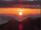
No rain overnight, but the tent was unsurprisingly wet with dew. I’d timed my alarm well, the sun began rising at around 5:35am I think, over South Olympus. It was absolutely glorious, and I managed to film it on my camera to create a time lapse for the video. A bit before 6am, I went back to the tent, and fell asleep again! Sometime before 7:30, I was up again, enjoying breakfast up at the summit rock cairn. With the sun in a different position in the sky, all the Du Cane peaks and Eldon Range mountains looked especially wonderful.
- Sunrise from the summit
I had to leave eventually, but I did my best to put if off as long as possible. I reckon it was a bit before 10am when I left the summit, and headed back the same way I came in. Everything was going as planned apart from the fact the strap on my gaiters (the one which wraps around the bottom of the boot) kept coming off every 15 minutes. It was a real nuisance, especially when you were surrounded by scrub. The only time I had any trouble on the descent was when I reached the lowest cliff. There was no way I could climb down it while wearing my pack. So I left it at the top and climbed down to that small ledge halfway down. I somehow grabbed hold of my pack and managed to keep hold of it as it fell down to my level. I didn’t know what to do from here. One hand was on a root, the other was keeping my pack from tumbling down the cliff. Eventually I just had to do something I really wish I didn’t. I crouched down as low as I could, and dropped the pack down the rest of the cliff. It fell a good 5 metres, before crashing into the ground and rolling a further 5-10 metres. Once I had navigated my way down, I went to inspect the damage. The drink bottles had come flying out and had a few scratches on them, but other than that, my pack and the contents inside had come through unscathed. 10 minutes later, I was back on the Overland Track, and another lunch stop at Echo Point was in order. As I walked back to Fergys Paddock though (as I was going to climb Mt Hugel the next day) I became more and more fatigued, and my feet felt very uncomfortable. Upon inspection that evening, it turns out I had a large bubble blister in between two toes on my right foot, and a hotspot on the back of my left foot. It was also this trip which made me realise that my boots are in real need of being replaced – some rubber is coming off on the bottom and there is almost no grip left on them either! That night I enjoyed a beer at the visitors centre – well deserved if I do say so myself!
- Beer to conclude the walk
In conclusion, Mt Olympus was a demanding, arduous, but extremely beautiful, amazing and outstanding walk. It has definitely been one of the highlights of my time bushwalking in Tasmania.
I made a video of the trip which can be viewed here for those interested: https://www.youtube.com/watch?v=qBg5c5grwz4&t=267s