It continued to rain on and off on the second day, including a few hailstorms while walking up the long hill to Barren Pass. But we were so astounded by the beauty of the forest and the views that the rain and hail didn't bother us at all. The walk between Lakes Vera and Tahune has got to be one of the most beautiful walking days of anywhere. I didn't notice the Huon Pines last time I was there... perhaps I just didn't know what I was looking at last time... it was a long time ago.
We decided not to climb Frenchmans Cap that afternoon, as we were expecting better weather the next morning. We were disappointed. The rain continued on the third day, but cleared to just thick clouds by the afternoon. We spent most of the day at Tahune hut reading books, and eventually climbed to the summit of Frenchmans Cap later in the afternoon. We enjoyed the climb but were a little disappointed by only a brief glimpse of a view between the clouds from the Summit. However the views on the way up were still good.
So on the fourth day, we headed out towards the Irenabyss. Finally the weather had come good... one day later than forecast, but better late than never. Since we had to go right past the mountain again, on the way through, wotrack? climbed the summit again, and this time got the full summit views from the top. I had seen the views before, and having just been up the previous day, and being a lazy sod, I waited for him at the summit turn off, and continued reading my book.
We then made the 1000 metre descent in altitude to the Irenabyss, which is a truly magnificent spot. Incredibly beautiful. Pity I had a splitting headache that afternoon. Never mind. We had a good rest and look around and thoroughly enjoyed just being in such a magnificent part of creation.
We packed everything into large plastic bags, and then into our packs, and then placed our packs themselves into large plastic bags. Tied up, then realised that my pack-hauling rope was a lot shorter than when we took it on the Arthurs. Oops! I'd been pilfering bits of it for my sailboard and other uses over the intervening years. o-oh!
Well we tied a bit of wood to one end, and tried some test throws. Yes, it was just long enough to reach the opposite bank. But we could have to fight the current and swim directly across to the steep bank, and not diagonally across with the current to the easy sandy landing spot.
All this figuring out while standing around near-naked, on the bank of the river. Thank goodness we had good weather for all this stuffing around! We could have frozen our... well... you know.
So wotrack? swam across first, and scrambled up onto the bank. Had to swim fast to get directly across to where the rope would reach without being swept downstream, but he did well. I tossed the across the bit of wood tied to the rope, and just missed his feet, but he was able to grab it. Lowered his pack in, and he pulled it across without problems. Untied the rope, threw it back, I pulled it across, tied it to my pack, threw the other end with the wood back again, took a couple of attempts to get it right this time, then lowerd my pack in and he pulled it across.
Then it was my turn to swim. Well, it was cold. But we were so grateful that it was nowhere near as cold as it could have been. Just a little colder than the 1st Basin in Launceston about a metre below the surface.
We untied the rope, and took off the outer plastic bags, donned out packs and scrambled through the forest to the smaller campsite on the Northern bank of the river. No terribly flat places to pitch a tent, but we found a spot that proved more comfortable to sleep on that it looked.
I won't give much in the way of detail for the last 2 days of the walk, as it involves a lot of off-track walking, in some sensitive areas (and hence would be against forum rules, although it's debatable as the route is well described on both Tasmap maps and in well known books). However, the weather was very good for the last two days. We managed to walk a 9 hour day on the second last day in order to make sure we got out OK on the last day. We knew both days would be tough, with a lot of scrub-bashing.
We avoided Mary Creek Plains (which the route passes through according to the 1:25,000 maps), and instead followed the route marked on the 1:100000 map which passes to the east of the plains. There were a few patches of scrub which were incredibly difficult to get through, but we eventually got most of the way along the ridge before Flat Bluff, and decided we'd better find somewhere to camp. Thankfully there were a few small patches of grass just a bit further on. One was just big enough and flat enough for the tent.
We saw no creeks, lakes, pools or other such water sources for the entire two days north of the Franklin. We sucked water out of yabbie holes using my yabbie straw. We found a group of yabbie holes near the camp site which had enough water to get a mug into, so we were able to collect enough to cook and clean with.
The final walk bit of the walk involved more scrub bashing from the Franklin Dam bulldozer exploration tracks to the Lyell Highway. We couldn't see a thing through the scrub the entire way down the hill, and were getting concerned that we could be heading slightly in the wrong direction by the time we got to the bottom. We eventually came to a fairly open spot and could see that we were very near the bottom, but we couldn't see the road, or even a gap in the trees where the road should have been. o-oh!
We decided to wait to listen for cars, since we'd heard some on the way down. Eventually one came past, and it was clear from the sound that it was only a few metres in front of us that it went past. So we continued on, and by some complete fluke (or perhaps by genius of instinctive navigation) we came out onto the road EXACTLY at the 'Victoria Pass' sign.
Yay!
A quick wash in the Collingwood River on the way to meat pies and pints at the Derwent River pub and then home.
Phew!
A really tough couple of days resulting in scratches all over my arms and knees, and my T-shirt being ripped to shreds in the scrub, but well worth it.
A short selection of the photos wotrack? took are below.
Rugged Ridge Line above Lake Vera
- P1030195.jpg (63.61 KiB) Viewed 19874 times
Me Admiring a Creek and Huon Pines
- P1030210.jpg (185.79 KiB) Viewed 19874 times
King Billy Stagg
- P1030260.jpg (68.16 KiB) Viewed 19874 times
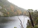
Artichoke Valley
- P1030279.jpg (126.67 KiB) Viewed 19874 times
wotrack? at the Summit Turnoff Sign
- P1030306.jpg (157.46 KiB) Viewed 19874 times
Cushion Plants Pool near the Summit of Frenchmans Cap
- P1030348.jpg (135.61 KiB) Viewed 19874 times
Rock
- P1030374.jpg (143.69 KiB) Viewed 19874 times
wotrack? looking Back to Frechmans Cap from the Irenabyss Track
- P1030394.jpg (124.5 KiB) Viewed 19874 times
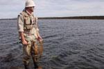
Me Relaxing at the Irenabyss
- P1030400.jpg (135.27 KiB) Viewed 19874 times
The Irenabyss
- P1030417.jpg (123.02 KiB) Viewed 19874 times
The Irenabyss
- P1030419.jpg (153.88 KiB) Viewed 19874 times
The Rocks from which we swam directly across (to the right of the picture)
- P1030407.jpg (142.3 KiB) Viewed 19874 times
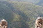
Me any my smelly socks at our rough makeshift 'campsite' on the ridge to the North East of Mary Creek Plains
- P1030456.jpg (110.87 KiB) Viewed 19874 times
Frenchmans Cap Sunset
- P1030457.jpg (38.77 KiB) Viewed 19874 times