Little Fisher River Track to Various Lakes (lots of pics)

Trip reports, stories, track notes. Multiple/large photos are OK in this forum.
Forum rules
Posting large/multiple images in this forum is OK. Please start topic titles with the name of the location or track.

For topics focussed on photos rather than the trip, please consider posting in the 'Gallery' forum instead.

This forum is for posting information about trips you have done, not for requesting information about a track or area.

Little Fisher River Track to Various Lakes (lots of pics)

Postby Son of a Beach » Wed 21 Oct, 2009 2:47 pm

Over the weekend (plus Monday) I walked up the Little Fisher River track with a couple of fly-fishing mates and camped near the southern end of the first of the Long Tarns and explored various other lakes in the area.

The drive in includes driving through a lot of clear-felled forestry area and dodging a huge number of wallabies (for the time of day) jumping around on the road - perhaps they're wondering where their forest went. Then over a very rickety old bridge which I can't imagine passing any engineering tests, and then this wonderful gateway to the "World Heritage Area":
IMG_0043.jpg
Wilderness Gateway
IMG_0043.jpg (62.25 KiB) Viewed 10655 times


The track basically follows the Little Fisher River (not to be confused with the Fisher River or the Fish River, both of which are nearby). About one and a half hours into the walk is Rinadeena Falls on a tributary creek. It's a pretty waterfall which is easily accessible as a day walk, and which you can walk in behind for the full length of the falls from one side to the other with only a few drops of water on your back (some photos of that later):
IMG_0045.jpg
Rinadeena Falls
IMG_0045.jpg (71.95 KiB) Viewed 10655 times


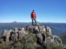
The track is uphill most of the 3 hours to the top of the plateau, with a 20 minute flat stretch about two thirds of the way up, and then finally levels off again just before reaching the Long Tarns, with some great views back down the river valley. The guys got the rods out as soon as they reached the tarns and caught a 3 pound trout very soon. Then the silly sods let it go - only a couple of hours before dinner time too! Unbelievable! They fished their way down the western side of the first long tarn, seeing a lot more fish, but not catching any more, and then being satisfied that it was a good fishing location, decided to set up camp here:
IMG_0059.jpg
Our Camp Site and one of the Long Tarns
IMG_0059.jpg (72.77 KiB) Viewed 10655 times


Although it had been sunny most of the day, it was very cold. I cooked dinner while the other guys continued fishing, and by the time we'd finished dinner (about 8:30pm, I think), they just flaked out in bed, and I was left wondering what to do with the evening. Well, not for long, because there was already frost on my pack, and I was getting very cold, so I hit the sack too.

The next day, we spent wandering about various other lakes, tarns and creeks to the East of the Long Tarns, for the sake of the fly fishing (I just wandered around and waited for them to not catch any fish all day). Some of the lakes we visited included Pencil Pine and Lexie (and one of the guys went over the Gwendy as well, but I needed to get back to camp for lunch by 3pm!). It was a very cold day again, and walking was the only thing that kept me warm. There is some beautiful countryside up there:
IMG_0060.jpg
Small Tarn in the headwaters well above Pencil Pine Tarn, with fly fishermen on either side.
IMG_0060.jpg (37.48 KiB) Viewed 10655 times

IMG_0063.jpg
There were still a few patches of snow around
IMG_0063.jpg (36.24 KiB) Viewed 10655 times


That night the other guys managed to stay up for a few minutes after dinner, while I shot-gunned a few Tim-Tams (they didn't want to participate - how strange!).

The third (and last) day was fantastic weather wise. I ducked over the hill to the Daisy Lakes before breakfast, while one of the other guys fished, and the other one slept in. The Daisy Lakes are beautiful, and I walked right around the Northern lake. Unfortunately, the cloud had not quite lifted off the mountains in the Walls of Jerusalem before I returned to camp, but I got the impression that the view would have been even more impressive if I could see the mountains better.

We then had breakfast, broke camp, and headed back along the Long Tarn to the main track, with the guys fishing all the way along.
IMG_0083.jpg
Long Tarn and Turrana Bluff.
IMG_0083.jpg (45.17 KiB) Viewed 10655 times


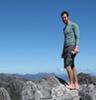
I then realised that the clouds had disappeared completely, and this would be my last chance to get the view I'd missed earlier in the morning. So I dropped the pack and raced back up the ridge again (between Long Tarns and Daisy Lakes). I was not disappointed. The view was spectacular, with what I think was Mt Jerusalem being the dominant peak (I hadn't seen it from that side before), and then the Temple and other peaks in the Walls, and then in the distance (and not shown in this photo) was what I think must be Barn Bluff with its head still in the clouds, which means that Cradle Mtn must have been just out of view behind Clumner Bluff (also not in this photo).
IMG_0086.jpg
View from near the top of ridge between Long Tarns and Daisy Lakes
IMG_0086.jpg (67.01 KiB) Viewed 10655 times

IMG_0092.jpg
Daisy Lakes (North) with Walls of Jerusalem in the Background
IMG_0092.jpg (57.31 KiB) Viewed 10655 times


Coming back down the hill to meet the other guys fishing their way back along the Long Tarn, the view of all the Long Tarns was also breath taking:
IMG_0096.jpg
Long Tarns
IMG_0096.jpg (58.08 KiB) Viewed 10655 times


I caught up with the guys fishing just as they were nearing the end of the Tarns, so they packed up their fishing gear, and we continued on back down the valley of the Little Fisher River. Not far down from the top of the track, is a great little rock ledge lookout over the valley where we stopped to have lunch.
IMG_0101.jpg
Lunch Time Lookout over the Little Fisher River Valley
IMG_0101.jpg (54.7 KiB) Viewed 10655 times


Nearing the waterfall again, one of the guys noticed these tiny pot holes one of which still had its resident pebble get tossed about by passing water, and increase the size of its own hole (presumably):
IMG_0112.jpg
Pebble Pot-Holes
IMG_0112.jpg (78.51 KiB) Viewed 10655 times


We stopped at Rinadeena Falls for afternoon tea again on the way out.
IMG_0113.jpg
From Behind Rinadeena Falls
IMG_0113.jpg (74.52 KiB) Viewed 10655 times

IMG_0117.jpg
Rinadeena Falls
IMG_0117.jpg (52.66 KiB) Viewed 10655 times

IMG_0122.jpg
Cooling the Feet at Rinadeena Falls
IMG_0122.jpg (83.14 KiB) Viewed 10655 times


Apologies for the quality of the photos. I was just using a phone camera.
Son of a Beach
Lagarostrobos franklinii
 
Posts: 7025
Joined: Thu 01 Mar, 2007 7:55 am
ASSOCIATED ORGANISATIONS: Bit Map (NIXANZ)
Region: Tasmania
Gender: Male

Re: Little Fisher River Track to Various Lakes (lots of pics

Postby Son of a Beach » Wed 21 Oct, 2009 2:50 pm

I should point out for the the sake of some readers, that the track up to Long Tarns is mostly easy to follow with only a few spots where it gets a bit vague and easy to miss in the forest. However, after reaching the plateau and the first of the Long Tarns, it's mostly trackless, with just a few vague foot pads around each lake (presumably from the feet of circling fishermen).

So if you plan to explore this area, you'll need to be moderately competent at navigation and off-track walking.

Now I'd better post a more expansive version of the view over Daisy Lakes, since I raved on about it a bit. Click the photo to see it larger.

This is a stitch up job of the view looking over Daisy Lakes (north) to Mt Jerusalem, the Temple and the Walls of Jerusalem, and then Barn Bluff in the far distance still partially obscured by cloud, and Clumner Bluff on the right, presumably just obscuring Cradle Mountain.
Daisy Lakes North.jpg


(I'm not entirely sure I've identified all these mountains correctly, so please feel free to put me straight if I've got them wrong).
Son of a Beach
Lagarostrobos franklinii
 
Posts: 7025
Joined: Thu 01 Mar, 2007 7:55 am
ASSOCIATED ORGANISATIONS: Bit Map (NIXANZ)
Region: Tasmania
Gender: Male

Re: Little Fisher River Track to Various Lakes (lots of pics

Postby eggs » Wed 21 Oct, 2009 2:56 pm

Fascinating - this area is firming up for next January.
And a great camera on your phone!
User avatar
eggs
Lagarostrobos franklinii
 
Posts: 10479
Joined: Fri 23 May, 2008 2:58 pm
Location: Para Vista, South Australia
Region: South Australia

Re: Little Fisher River Track to Various Lakes (lots of pics

Postby Son of a Beach » Wed 21 Oct, 2009 3:03 pm

eggs wrote:Fascinating - this area is firming up for next January.
And a great camera on your phone!


The camera does quite a good job in ideal conditions. Being able to touch the point in the image on the screen that you want to use for focus, exposure, etc, provides a little bit of control. It's appalling at handling anything with high contrast (eg, dappled sunlight in a rainforest), which meant I missed out on some other wise great photo opportunities.
Son of a Beach
Lagarostrobos franklinii
 
Posts: 7025
Joined: Thu 01 Mar, 2007 7:55 am
ASSOCIATED ORGANISATIONS: Bit Map (NIXANZ)
Region: Tasmania
Gender: Male

Re: Little Fisher River Track to Various Lakes (lots of pics

Postby Nick S » Wed 21 Oct, 2009 3:20 pm

I like that first photo - into the ominous dark forest..
Looks like a great weekend trip.
User avatar
Nick S
Phyllocladus aspleniifolius
 
Posts: 624
Joined: Thu 20 Mar, 2008 4:55 pm
Location: Launceston
Region: Tasmania
Gender: Male

Re: Little Fisher River Track to Various Lakes (lots of pics

Postby DaveNoble » Wed 21 Oct, 2009 5:25 pm

Beautiful Country!! I want to go back there......

Dave
DaveNoble
Athrotaxis selaginoides
 
Posts: 1031
Joined: Sun 03 Feb, 2008 3:56 pm

Re: Little Fisher River Track to Various Lakes (lots of pics

Postby flyfisher » Wed 21 Oct, 2009 9:09 pm

Beautiful Country!! I want to go back there......


Yeah, me too Dave. Been walking parts of it for 30 years or more and never get tired of it, but I must explore the southern end more.

ff
If you don't know what I'm talking about, then you need to drink more.
User avatar
flyfisher
Athrotaxis selaginoides
 
Posts: 1532
Joined: Sat 14 Jul, 2007 8:39 pm
Location: hobart
ASSOCIATED ORGANISATIONS: landrover owners club of tasmania
Region: Tasmania

Re: Little Fisher River Track to Various Lakes (lots of pics

Postby billyc89 » Thu 22 Oct, 2009 6:10 pm

Where/how do you access the beginning of the little fisher river track? Is a 4wd necessary to access the road?

Cheers,

Billy
billyc89
Nothofagus cunninghamii
 
Posts: 4
Joined: Mon 12 Oct, 2009 1:30 pm
Region: Tasmania
Gender: Male

Re: Little Fisher River Track to Various Lakes (lots of pics

Postby Son of a Beach » Thu 22 Oct, 2009 7:45 pm

Follow the Mersey Forest Rd to Lake Rowallan. Turn left into Dublin Rd just past the Rowallan dam wall. You've then got to drive through a lot of forestry works past several forestry side roads which are not on the map, and then eventually turn right into Little Fisher Rd (I can't remember if this road had its name on a sign or not, but look out for the sign in the first picture above). Its a little rough, including a bridge that looks rather unsafe. But a two wheel drive is fine for this road.

The carpark at the end of the road is rather small. 4 cars would make it crowded.
Son of a Beach
Lagarostrobos franklinii
 
Posts: 7025
Joined: Thu 01 Mar, 2007 7:55 am
ASSOCIATED ORGANISATIONS: Bit Map (NIXANZ)
Region: Tasmania
Gender: Male

Re: Little Fisher River Track to Various Lakes (lots of pics

Postby sthughes » Fri 23 Oct, 2009 2:12 pm

Awesome - been wanting to go up to that area.
What sort of phone is it - they aren't too bad!
"Don't do today what you can put off 'till tomorrow." (Work that is!)
User avatar
sthughes
Lagarostrobos franklinii
 
Posts: 2427
Joined: Wed 05 Mar, 2008 12:53 pm
Location: Ulverstone
Region: Tasmania
Gender: Male

Re: Little Fisher River Track to Various Lakes (lots of pics

Postby Son of a Beach » Fri 23 Oct, 2009 2:22 pm

sthughes wrote:Awesome - been wanting to go up to that area.
What sort of phone is it - they aren't too bad!


It's a current model iPhone, "iPhone 3GS", purchased to feed my application development hobby. The built in camera is 3 MP (2048 × 1536). I kept the phone in a zip-lock bag (except for when taking photos). I found that the touch screen works perfectly well in the plastic bag. However it does not work with even the thinnest of gloves on, even out of the bag. Nor does it work with my big honker of a nose. It seems to require actual fingertips, but copes fine with a thin plastic bag membrane in between.
Son of a Beach
Lagarostrobos franklinii
 
Posts: 7025
Joined: Thu 01 Mar, 2007 7:55 am
ASSOCIATED ORGANISATIONS: Bit Map (NIXANZ)
Region: Tasmania
Gender: Male


Return to TAS Trip Reports & Track Notes

Who is online

Users browsing this forum: No registered users and 7 guests