Page 1 of 1

Tyndalls, Jan 08

PostPosted: Sun 25 May, 2008 6:46 pm
by eggs
A few photos from a short visit to the Tyndall range in Jan 2008.
The weather was good but some evening cloud came in before a cloudless morning.

TrackUp.JPG
Track in to Mt Tyndall is steep


ViewNorth.JPG
Looking North across the top of Mt Tyndall late afternoon


ViewEast.JPG
View East towards Eldon Peak - note people on the top for scale

Re: Tyndalls, Jan 08

PostPosted: Sun 25 May, 2008 6:52 pm
by eggs
ViewSouth.JPG
Looking from Mt Tyndall over plateau lakes to Geikie


LakeTyndall.JPG
Panorama across Lake Tyndall to Mt Tyndall at sunrise


TowardsGeikie.JPG
One of many tarns on the plateau

Re: Tyndalls, Jan 08

PostPosted: Sun 25 May, 2008 6:57 pm
by eggs
TowardsDucane.JPG
Sunrise looking towards the Ducaine Range


AcrossSedgewick.JPG
Mt Sedgewick with Frenchman's Cap in the distance


LakeTyndallBeach.JPG
The purple beach at Lake Tyndall

Re: Tyndalls, Jan 08

PostPosted: Sun 25 May, 2008 7:01 pm
by eggs
GeikieLake.JPG
Reflections on Lake Tyndall


LakeHuntley.JPG
An awesome drop down to Lake Huntley


HuntleyCliffs.JPG
Looking across the cliffs over Lake Huntley

Re: Tyndalls, Jan 08

PostPosted: Sun 25 May, 2008 8:47 pm
by tasdaz
Fantastic photos and looks like an amazing place to walk.

Re: Tyndalls, Jan 08

PostPosted: Tue 27 May, 2008 1:00 pm
by tasadam
It's photos like these that inspire me to go to such places.
Well done!

Re: Tyndalls, Jan 08

PostPosted: Tue 27 May, 2008 8:07 pm
by flyfisher
It's photos like these that inspire me to go to such places.
Well done!


Yeah me too. Absolutely fabulous shots :D :D

FF

Re: Tyndalls, Jan 08

PostPosted: Tue 27 May, 2008 10:17 pm
by corvus
Wow fantastic checking out my maps and Google Earth ,in you opinion could a couple of reasonably fit experienced 60 + year olds handle this .
corvus.

Re: Tyndalls, Jan 08

PostPosted: Wed 28 May, 2008 12:23 am
by eggs
Being a South Aussie, I have not been to Tasmania much, but 26 years ago I spent 2 months working in a west coast mine.
This part of Tasmania is a mix of overgrown historical remnants and some very tough but beautiful country.
During that stay I got onto Geikie Peak via Lake Margaret township - basically using the various 4 wheel drive roads to start.
Since then the road servicing the Anthony hydro scheme has gone in and more formal tracks have been established onto Mt Murchison and also to Mt Tyndall.

I actually discovered this newer track up Mt Tyndall from the rock climbers that go in to climb the 300m cliffs over Lake Huntley.
The link is http://www.thesarvo.com/confluence/disp ... dall+Range

This is a track complete with registration book.
It leads to the ridge top and then more poorly to the main lake on the plateau. Apart from that you have to find your own way.
Of the few who visit, many do this as a day walk to the top of Mt Tyndall. It would be much easier without heavy packs.
We were not particularly fit when we attempted it (I am 49 years old) and it is a sustained but basic climb of about 600m and we took about 2 hours 30 mins to the ridge top.
The start is a short scrubby bit - and I am told when wet it can be very leech infested. But after that it is a very open walk.
I actually prefer the steep climbs, but you may need a few rest breaks as it is a relentless stretch of always up.
I suspect fit 60 year olds would have little trouble even if they have to take their time.

I must warn that the top is very exposed and can be subject to some terrible west coast weather so try and make sure of a reliable weather report before going - or be prepared with some very good gear. We were not up there long enough, but I hope to go back some time and may try some other spots for camping. Bad weather would also make navigation very difficult as Mt Tyndall itself is a maze of big blocks of rock that you work your way through. Let me know if you need any more info.

I know it was very special weather we had so I will post a few more photos - I hope that is OK.
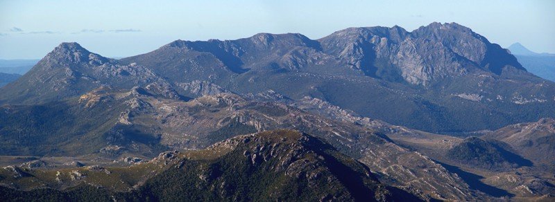
MurchoPan.JPG
Panorama of Mt Murchison from Mt Tyndall
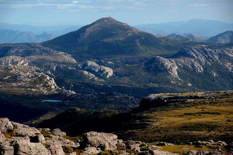

Sedgewick.JPG
Mt Sedgewick in late afternoon light


DawnPonds.JPG
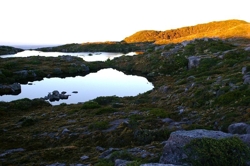
Some more tarns perched on the western edge just on sunrise

Re: Tyndalls, Jan 08

PostPosted: Wed 28 May, 2008 12:37 am
by eggs
MtRead.JPG
Campsite on Lake Tyndall with Mt Read behind - I suspect a west wind would whip through here with little protection.


TyndallForest.JPG
Lake Tyndall reflections of a patch of forest


Lake.JPG
Another lake below Mt Tyndall. Note the rock mazes on the top left

Re: Tyndalls, Jan 08

PostPosted: Wed 28 May, 2008 12:45 am
by eggs
RockPonds.JPG
There were numerous tarns amongst the rock shelves


RockReflections.JPG
And the reflections were good


BivouacCave.JPG
These are some pools above the 300m cliffs of Lake Huntley. Climbers sometimes use a bivouac cave here

Re: Tyndalls, Jan 08

PostPosted: Wed 28 May, 2008 8:34 pm
by corvus
Many thanks eggs I am planning my trip for Summer now ,I have a son who works in Queenstown so I pass the start of this track regularly when I visit and often comment that I would love to go for a walk there.
corvus

Re: Tyndalls, Jan 08

PostPosted: Thu 29 May, 2008 9:48 am
by Mickeymoo
Great shots Eggs I'v been wanting to get up this way for some time but never have, now seeing your photos I will have to make sure I do get up there :D

Re: Tyndalls, Jan 08

PostPosted: Mon 02 Jun, 2008 11:20 am
by PeterJ
corvus wrote:Wow fantastic checking out my maps and Google Earth ,in you opinion could a couple of reasonably fit experienced 60 + year olds handle this .
corvus.


We went there at the end of April and had no difficulty. A steady climb which took us about 2 3/4 hours from the car to camp. One of our party was lucky enough to be 59 whilst the rest were from 63 to 68.

A couple of photos from the walk.
IMG_0827.JPG
View to Lake Huntley
IMG_0827.JPG (138.39 KiB) Viewed 24330 times
IMG_0852.JPG
Fagus on range
IMG_0852.JPG (232.64 KiB) Viewed 24332 times

Re: Tyndalls, Jan 08

PostPosted: Sat 07 Mar, 2009 12:59 pm
by Mp3robbo
Nice pix man, I've been up there myself and have been wanting to go back up there. We went on a cloudless day in April, but didn't have the time to get to the summit, but we got to the edge of Huntley. I've included a couple of pics of my trip. :D 8)

Re: Tyndalls, Jan 08

PostPosted: Mon 09 Mar, 2009 1:09 pm
by eggs
Mp3robbo

welcome to the forum.
I hope you can get back there in good weather again.

Yours is the second time I have seen web photos over Kristy's Pool and we missed it when we were up there.
I presume it is a bit down from the line one would take when going from the top of the cairned track across the back of Mt Tyndall towards Lake Huntley.
Can you remember what the area a bit to the right of your photo was like?
Is it a flat grassed area with rock walls to the north & west?

Brian

Re: Tyndalls, Jan 08

PostPosted: Mon 09 Mar, 2009 2:16 pm
by kanangra
Excellent photos. another for my "to do list"

Re: Tyndalls, Jan 08

PostPosted: Fri 27 Mar, 2009 5:03 pm
by Mp3robbo
eggs wrote:
Can you remember what the area a bit to the right of your photo was like?
Is it a flat grassed area with rock walls to the north & west?

Brian


It was a long time ago and I don't really remember, sorry.

Re: Tyndalls, Jan 08

PostPosted: Tue 16 Jun, 2009 4:12 pm
by eggs
Just a short post script

In the game "Where am I?" something tasadam queried highlighted to me another aspect of this January trip.
That was the fantastic array of alpine herbs at the top of Mt Tyndall.
The entire top of the mountain is a maze of small cushion plants mixed with alpine herbs, and at the time we were there, the Milligan's Mountain Heath was all out in flower. It was everywhere on the plateau (you can pick it in some of the photos above), but very abundant up top. In fact it looked so delicate that we took some care to try and minimise any foot damage. If this spot got a lot of traffic I suspect it would wear fairly quickly. But for now it is quite pristine.

So I am adding a couple more photos from that trip.
This one gives a broader view from the top looking south, and better shows the position of Frenchman's Cap on the left side horizon with the West Coast Range running south, Geikie Peak at the other end of the adjoining plateau, and then going from left to right into the distance, Mts Sedgewick, Lyall is a slight bump, then Owen, Jukes and Sorrell. There are a couple of peaks hidden, and the last and tallest of the West Coast Range is Mt Murchison which is behind, to the North.
IMGP4366bSmall.JPG
Wider view from top of Mt Tyndall looking South - note the Milligan Mountain Heath in flower


There are no large patches of cushion plants, but inumerable tiny patches, and it was also in flower.
IMGP4374Small.JPG
Cushion plant in flower


I have borrowed a photo from another of our party to better show the profusion of flowers.
It is a gradual rise and flat top to this mountain, but it is a huge drop where my son is sitting.
I had to enhance the colour a bit in this photo as it was quite dark when it was taken, but the conglomerate rock which dominates throughout the range is bound together by a very pink material.
PICT0355aSmall.JPG
Looking up to the remnants of the old trig point on Mt Tyndall

Re: Tyndalls, Jan 08

PostPosted: Tue 16 Jun, 2009 4:35 pm
by walkinTas
Blast Eggs! Now I will just have to visit the Tyndalls next January. See what you've done! Another week camping out the the open fresh air all by myself without a care in the world. How will I cope?

:D Is there a track? Do you have GPS points?

Re: Tyndalls, Jan 08

PostPosted: Tue 16 Jun, 2009 4:58 pm
by eggs
This was a long thread, but there was a discussion on access in the middle

"I actually discovered this newer track up Mt Tyndall from the rock climbers that go in to climb the 300m cliffs over Lake Huntley.
The link is http://www.thesarvo.com/confluence/display/thesarvo/Tyndall+Range "

GPS I don't have, but the track is clear up until the top of the initial rise. It is open walking all over Mt Tyndall & the plateau. Just need to be able to see things, as there are some large rock jungles on Mt Tyndall's south slope.

Re: Tyndalls, Jan 08

PostPosted: Tue 16 Jun, 2009 5:59 pm
by walkinTas
Read! Yeah, that's and idea. :lol:

I was so busy looking at the pictures I miss it!

Re: Tyndalls, Jan 08

PostPosted: Thu 19 Nov, 2009 4:51 pm
by eggs
Rather than start a new thread, I thought I would note that the Lake Margaret Power Station appears to have been officially re-opened on 12th Nov.

If any one knows, can they please let us know when we can get walking access back into the old town site and along the tramway.
Great place to tackle Geikie peak - and I suspect it would be great for approaching Mt Sedgewick as well.
I have been along the tramway and ascended up the southern slopes to the top of ridgeline that then runs all the way around to Sedgewick - and it looks very straightforward.