South West Cape circuit trip notes

Trip reports, stories, track notes. Multiple/large photos are OK in this forum.
Forum rules
Posting large/multiple images in this forum is OK. Please start topic titles with the name of the location or track.

For topics focussed on photos rather than the trip, please consider posting in the 'Gallery' forum instead.

This forum is for posting information about trips you have done, not for requesting information about a track or area.

South West Cape circuit trip notes

Postby stuart53 » Sat 24 Mar, 2012 2:55 pm

Just back from doing the South West Cape circuit (Melaleuca – New Harbour – Wilson Bight – Window Pane Bay - Murgab Creek – Horseshoe Inlet – Melaleuca) and have a few comments that might be useful to anyone taking this route. It was a fantastic experience with unparalleled scenery but very physically challenging. We had generally good weather (patchy rain the first two days and heavy rain & wind from Horseshoe Inlet to Melaleuca) and didn't have any serious problems with navigation, feet, equipment failure etc. We're four old *&%$#! and we've done long walks at least once each year for the past decade. This was by far the most difficult. We did eight days in the King Leopold Ranges in the Kimberly in 2010 and the South Coast Track in poor weather in March/April 2011 and this route was harder than either. I know there are much rougher routes in SW Tas but this one is pretty unremitting from the time you leave Wilson Bight to the time you get back to the Port Davey track.

A critical safety issue with this walk is that not many parties do it – the track logs recorded 20 parties in the previous 14 months. That's about one every three weeks. If you get into trouble here you can't expect to wait for someone to come along and help you out. We took a Find-Me-Spot GPS communicator which allowed the folks back home to keep track of our movements and read simple messages about progress. An EPIRB is an alternative although a bit less flexible.

I'll basically ignore the first two days to Wilson Bight as these are on well-defined tracks, carry much more traffic and are within (relatively) easy reach of Melaleuca. Chapman notes that the rocky point on Wilson Bight is difficult to cross at high tide. We found it difficult in very mild sea conditions and I'd suggest that in serious storm conditions crossing this point via the rocks would be impossible. It might be possible to go over the top. On the other hand, in really bad weather you don't want to be on the SW Cape Range, so being cut-off from the start wouldn't be a bad thing.

STU-PANARAMA2.jpg
Dunes at the back of Hidden Bay


Wilson Bight to Window Pane Bay
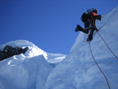
The real challenge starts with the day from Wilson Bight to Window Pane Bay. Chapman calls this a 7 to 9 hour day. We left at 8 am, walked all day with only brief breaks for snacks and drinks and didn't get to WPB until just on dark at 8 pm. I'm sure there are people out there who'll report that this did this section is under 5 hours with a broken ankle and carrying a dead goat but if you look at the SW Cape circuit blogs 12 hour days seem to be a normal experience. We managed the next two sections in pretty much the times Chapman indicates so I don't think we were being especially feeble. There are a couple of points where you can get lost (but while we had to stop and check location twice we didn't stray off the route) and we had generally fine weather. It's a very deceptive route in that it's “only” 15 km and “only” 650 metres at the highest point (although in total it must be more like 800 metres of ascent and descent) but we struggled to manage more than 1.5 km an hour over most of it.

One issue is that there are extensive sections where there is no defined foot track to follow. There's a good track all the way to Mt Karamu but this peters out shortly after you leave the peak and you are then faced with a couple of kilometers of moorland until a track reforms on the climb up onto the main part of the range. In clear weather it's pretty obvious where to go but in bad weather you'd want to do some very careful navigation through this section. There's a clear track along most of the spine of the range and up to the peak but this disappears again on the first part of the descent to WPB. There is a large tarn just after you get up onto the main part of the range as well as the small ones near the peak referred to in the track notes. After you leave the peak there is a well-defined track leading out to the north-west but it's a false lead – the correct route is to the north, but the foot track is difficult to spot even in good weather. The last hour is through forest behind Window Pane Bay and if it gets dark when you're here way-finding could be very difficult. There are a couple of bottles that mark the trail in the forest but some sections are very vague. So, when you're doing this section you need to allow a very full day and have good weather when you're on top of the range.

STU-PANARAMA3~cropped.jpg
Top of the SW Cape Range looking north


Window Pane Bay to Murgab Creek
The next day to Murgab Creek was fairly straightforward. Chapman's notes say that the track behind Faults Bay is faint and hard to follow but we found it very clear. Someone has marked much of this part of the route with plastic rope and bits of craypot. The only difficulty is the last bit – the track notes refer to following the rocky shore but this is a bit more complicated than just walking along rocks. The shore platform is very exposed – we had moderate surf and it was breaking across the shore platform. There are also a couple of deep gulches where for practical purposes there is no shore platform. At the back of the shore platform is a steep rocky cliff around 10 to 15 metres high and there is a track around the upper edge of this. It's exposed in places and there is quite a bit of erosion, and eventually you're forced back into the forest at the second of the gulches. The forest is actually not too bad to pass through and a better route for this last section might be through the forest. Brian lost his dunny trowel somewhere in here and he'd like it back if anyone finds it. The track notes refer to the campsite as being 50 metres up from the outlet but the outlet is now well down to the southern end of the bay. Cross the outlet at the mouth and look for the chain and timber ladder leading up to the campsite. There's a small campsite close to the beach and a larger one with access to the creek further in.

Murgab Creek to Horseshoe Inlet
There is a well-defined track up the first hill behind the dunes at the back of Murgab Creek and this leads north across a series of knolls. It's a very clear track but unfortunately it's not the correct route. This was the only place we got substantially off-route and had to go cross country for a kilometer to pick up the correct route. This track might be a back way to Spain Bay but I suspect it's just a wombat trail that successive groups of walkers have followed in error. The route up the SW Cape range is clearly defined but it disappears on the top of the range. The way down is also well defined but you need to climb the knoll at the edge of the range to pick it up. The same thing happens on the Pasco Range. The route down to Horseshoe Inlet is very clear until the last few hundred meters where it peters out. However the band of scrub at the edge of the inlet isn't too thick. Wading around the inlet is an experience to treasure. The first bit is across a very gluey mud bottom and it's easy to slip on this – walking sticks are a great help. The bottom gets sandier as you proceed, especially after you cross the second of the three creeks. We had a lowish tide and fairly calm weather but elected to swim the first creek (packs in garbage bags) as the prospect of slipping in the mud while wading chest deep around the bar and balancing a pack on your head didn't appeal. In either case you have to strip off and put your pack in a bag, and the swim is not very far. If you swim it's easier to enter and exit this creek nearer the mouth – higher up the eastern bank is pretty steep. The second and third creeks were a reasonably easy wade – there's a stick marking the bar on the second creek. The water in the inlet wasn't too cold and the day was warmish (for SW Tas), although it did rain all the way. We were all pretty chilled by the time we reached the campsite. It's not far around the inlet but it's slow progress, especially early on. In colder weather hypothermia on this section could be a real problem – there are some beaches after the last creek where you could pull out and warm up but a better solution might be to wear waterproof pants to limit the heat loss. Finding the campsite was a bit of a challenge as there's nothing much on the shore that marks it out. It is in tea-tree scrub behind a gravel beach but it's pretty ordinary as campsites go. Again, this is a pretty big day and you'll be glad of that bowl of hot soup.

TAS2012_Panorama.jpg
Heading up onto the SW Cape Range from Murgab Creek


Other than the King Leopolds, this is the most isolated country we've walked through (there's hardly any mud after Wilson Bight!) and that's part of the attraction. The beach campsites are fantastic (especially Wilson Bight and Window Pane Bay), the high level views are stunning, but the country in between is scrubby in places (the term “light scrub” will take on a whole new meaning on the way up to the peak of the SW Cape range) and rough, and the climbs up and down the SW Cape and Pasco ranges are steep. Go and see it for yourself, but don't say you weren't warned.

Brian, Steve, Stu and Tony
Last edited by stuart53 on Mon 16 Apr, 2012 8:38 pm, edited 2 times in total.
User avatar
stuart53
Nothofagus gunnii
Nothofagus gunnii
 
Posts: 18
Joined: Wed 11 Jan, 2012 2:54 pm
Region: Victoria
Gender: Male

Re: South West Cape circuit trip notes

Postby Gippsmick » Sat 31 Mar, 2012 10:31 am

Thanks Stuart. Good notes on the route. I recently completed the circuit in reverse and found much the same thing. Stunning country for sure and an awesome route.
User avatar
Gippsmick
Athrotaxis cupressoides
 
Posts: 113
Joined: Wed 08 Oct, 2008 12:02 pm
Location: East Gippsland - Victoria

Re: South West Cape circuit trip notes

Postby Ranger-Jules 1 » Sat 19 Jan, 2013 10:06 am

We are off to do this walk on Monday the 20th of January. Leaving for Hobart tomorrow on Sunday the 19th. We have all the notes and clues people have given us, but are still concerned about the way around Wilson's everyone reckons that is a difficult point! Also hoping for good enough weather to cross to WPB. A bit nervous, did the South coast track 2 years ago and Overland track last year with some of the Western Arthurs after that. We know it is not an EASY walk. We have trained in the heat in QLD so will be getting some cooler weather down there to contend with. Trying to get to HIdden Bay the first night if possible, our flight is in the morning so should arrive with a lot of daylight. Still very heavy packs can slow you down and crossing hilly country really slows ME down. I am not the fastest walker by far. Do not want to disappoint my husband or our son by being a weakling in the group though! we will give it our best shot and hope for a good outcome. Anymore clues would be greatly appreciated.
Ranger-Jules 1
Nothofagus gunnii
Nothofagus gunnii
 
Posts: 18
Joined: Sat 19 Jan, 2013 9:55 am
Region: Queensland

Re: South West Cape circuit trip notes

Postby tasadam » Sat 19 Jan, 2013 10:31 am

If you want to call me today you are welcome to, you will find my number on my business card.
User avatar
tasadam
Magnus administratio
 
Posts: 5900
Joined: Tue 10 Apr, 2007 6:58 pm
Location: Near Devonport, Tasmania
ASSOCIATED ORGANISATIONS: TasmaniART, Smitten Merino, Macpac
Region: Tasmania
Gender: Male

Re: South West Cape circuit trip notes

Postby tasadam » Sat 19 Jan, 2013 11:46 am

Quick points.
Around Wilsons... Around Wilsons Bight?
Walking around Wilsons Bight is easy enough, made difficult if the tide is high or the seas are pumping, as you may have seen in my gallery.
You arrive at Wilsons Bight, as you approach it, it looks fairly straightforward (though we did see an extraordinary number of leeches between Ketchem Bay and Wilsons Bight).
If the tide is out, the beach parts are easy, just look a nd see whether it appears the sand is wet like the waves have been coming right up - they seem to come in sets, only a problem if the seas are high like 5 metres when we were there last time.
Climbing around the rocky parts is like this - fairly easy unless the seas are huge.
When the seas are big, this turns into this (looks worse than it was, she stayed dry), and this turns into this (we didn't muck around crossing that section of beach and climbing the rocks last time, but this time was casual.
Bear in mind, the seas that day were exceptional, and if they are not high, crossing Wilsons Bight is easy by the standards of what you have achieved to get there. Even if the seas are high, you just take your time and stay high on the rocks.

The track to New Harbour isn't that hilly, you should be able to make good time until the turnoff from the South Coast track, then the hilly bits are very minor so nothing really to worry about there. No water until about half hour beyond the turnoff where you start to head around New Harbour Range - you come to a creek with a short steep pinch on the other side of it - where we had lunch and a nice refreshing drink. Just before you cross this creek is a track leading east (left), takes you 10 metres to the creek where there is better water.

Getting to Hidden Bay on the first night - depends on the time you take to get to New Harbour I guess. When you leave New Harbour the track starts up through a forest and there are a number of fallen trees - a real obstacle course, a bit difficult to climb through the trees with heave packs, but certainly possible, just take care - careful not to slip so as to not put your back out or something. Like you are lying face down on a log sliding over it with your pack going out sideways as you leave the log, can't stand as there is a branch above you... Tests your strength. Only short sections of mucky stuff like this but saps your energy.

Once you are through the first half hour or so from New Harbour towards Hidden Bay, the track is less demanding and you should find getting to Hidden Bay easy enough. Certainly by the time you reach the open ground where you get a view north towards Mt Melaleuca you can do the rest by torchlight if needed (though preferably not).

Crossing South West Cape Range, this time I split it into 2 days and had a high camp - brought about mainly from the heat climbing from Wilson Bight. Wanted a high camp anyhow. Doing it in one day is a demanding day, especially when you chew up a lot of time stopping to take photos... But camping on the range can be interesting if you get some weather. Water can be scarce up there depending on weather.
After we camped on the range, we continued along then down to Window Pane Bay and got a bit of interesting weather - see this video - http://www.youtube.com/watch?v=MRwpIyldyPQ
The pad along the range can be tricky to follow in these conditions - if you find yourself no longer on the pad but walking in the scrub and it doesn't look right, stop and check where you are. Continuing would likely make it pretty difficult.
I was crossing a larger rocky section in these conditions, of course there is no pads on the rocks, and couldn't find the pad on the other side. Continued north along the top of the range as notes suggest, come to a rocky ledge, cannot see through the fog to the ground below, getting off it looked easier to the left than the right. Thick scrub to the left, clearly not correct, pull the map & gps as was curious how far along the range we'd come. Track was about 80 metres to the right (east). No big deal, but continuing through the scrub would have been a bad move.
User avatar
tasadam
Magnus administratio
 
Posts: 5900
Joined: Tue 10 Apr, 2007 6:58 pm
Location: Near Devonport, Tasmania
ASSOCIATED ORGANISATIONS: TasmaniART, Smitten Merino, Macpac
Region: Tasmania
Gender: Male

Re: South West Cape circuit trip notes

Postby stuart53 » Wed 13 Mar, 2013 7:59 pm

Hey Ranger-Jules, how did you go? Did you find Brian's dunny trowel in the scrub at Murgab Creek?
User avatar
stuart53
Nothofagus gunnii
Nothofagus gunnii
 
Posts: 18
Joined: Wed 11 Jan, 2012 2:54 pm
Region: Victoria
Gender: Male

Re: South West Cape circuit trip notes

Postby Ranger-Jules 1 » Fri 15 Mar, 2013 10:07 am

Sorry Stuart, we did not get that far! We started out in overcast weather with the promise of some big rain at some stage. Our flight into Melaleuca was very interesting to say the least. A lot of low cloud impeded the views, but once the Pilot found a hole in the clouds, we spiralled down into Melaleuca. I was thinking what the hell happened here?? One minute we were in the air, next we banked sharply and I did not know if we were up or down or going over. Then I saw hills, and thought, we may hit those hills!! Well we didn't and may I say what a fantastic pilot we had.
Three of us left a very dry hot QLD and we were glad to have done some training in the high humidity(it was hell) as we did get some high humid days with some heat. Still the fresh, clean air of Tasmania was a pleasant change for us.We were not to know at that stage what was in store for Brisbane and QLD! Our first day was to New Harbour,Justin our son, myself and husband John decided to set up camp here in this beautiful spot, even though Justin and I had wanted to go further. Just too hard to pass this lovely place. We were told there was NO mud going to the South west cape!! I think my sister in law was having me on, as there was a lot of mud all the way to Wilson Bight.
Overcast afternoon, but gorgeous sunset. Comfy camp, we set up with tarp just in case of rain. Packs quite heavy, but our weights were pretty good really. John was carrying around 18kgs, Justin 19kgs and I was carrying around 15-16kgs. We have very light weight gear and I dry all our own food. Nice meal of curried lamb and rice. I also do dried fruit and took Adam's advice to use sustagen on big days, and it works! Got a lot of advice before we came on this walk, from a lot of people.

Day 2, we packed up and set off for Ketchem Bay. After arriving at Hidden bay we ran into quite a few walkers heading back to Melaleuca and warned them of the rain coming, as they were doing the South coast track.This is where we got our first "shower" more like a down pour, as we got wind blown into us going to Ketchem bay and it was like a waterfall going down into the bay, we got quite wet here. Our clothes got a bit wet even with the rain coats and our boots were very wet. We had run through water and stayed dry, but rain just runs down your legs through the gaiters into the sock and boots. Not nice! The camp site was cramped with a few tents,so we went back to the rocks and climbed up to Ketchem Hts and set up there. Sun out and all our gear got dry. Fantastic afternoon with great company of others. Swapped some funny stories and enjoyed a beautiful sunset.

Day 3: Headed for WIlson Bight, my fear was rising after hearing all the stories about the rocks and how difficult it can be in big swells etc. The views from the Amy range were fantastic and I loved this bit. Even though it was a bit overgrown, we had no problems even in shorts. We were told we would get very scratched, I think people do not realise we train in areas of Lawyer vine and barbwire vine in QLD, that stuff tears you to pieces, but we usually always wear shorts in any case. Just suffer the cuts and scratches. Leeches in Tassie are so small, but so sneaky. We had quite a few of these, I opened my gaiter at one stage to find about 30 sitting in there, but the rid we used prevented them getting passed my socks, still got one or two on my ankles though! In QLD they are huge and you can usually feel them, as they can really sting. Got to the part where we had to go around the rocks and Justin and John checked it out. THey decided it was safe to go. I had to fight off trillions of march flies while waiting and killed about 20 in one hit. Crossing the rocks I was slow, as some are slippery and Justin carefully guided me across. John was very upset with me when I had finished, saying I was too slow and next time let them take my pack, as he was worried about the swell, at that stage there was none! WOW what a beautiful campsite, but we headed further along the beach to the closest point to Mt Karamu. I tested myself in cold water in the afternoon in the creek, I needed to know if I could stand a swim further on in the trip. I convinced myself I was fine and had an epi pen and had been taking antihistamines for over a week.Justin and I were very excited about our early start the next day for the big push!

Day 4 John awoke me at 3.30am and told me he wanted us to abort the trip as the rain that was coming was worrying him somewhat and he did not want me to swim 3 creeks, as well as the fact he did not know how much rain we could get, we only knew it could be 20mls or much more! He thought we may get trapped somewhere and not knowing the area should pull back and try again some other time. Justin and I were very disappointed of course, but could not argue the fact that we did not know the terrain well enough to push on. Justin and I wanted to push on, but with this dreadful allergy of mine with the cold(urticaria), I could see John's point of view and why he was worried. They kept coming up with ideas of how to keep me dry in the water! Like tying the neo airs together and floating me across. I also was going to wear thermals just to help a bit. I am sure I would have been fine, but at the time you make decisions based on the info you have at hand.
We decided to climb Karamu anyway, so sunrise was coming up over the cape as we climbed up, with considerable lighter packs. Enjoyed the beauty and isolation of this magic place and then turned back. Packed our gear and headed for Hidden bay for the night. I crossed the rocks much more quickly the second time, knowing what ones were slippery etc.
Ran into a young woman when we left Ketchem bay. She was hoping to join someone in doing the Cape. She had done the South Coast track on her own and carried a huge pack, she was tiny!! Such a brave young lady. We set up camp at Hidden bay and waited for the rain! We met her again early next morning going back to Melaleuca and off to Mt Rugby via Horseshoe bay and doing the Port Davey track and having to row those boats alone. I heard later she did it all on her own and just amazed everyone back at Melaleuca. What an awesome young lady, her name is Yolande!

day5, I was really disappointed that the rain had been delayed and we had heard more reports it would be pretty full on. It did finally come, but less than what was predicted and of course you then feel a bit cheated! Still decision had been made, so we carried on with our new plans. We decided to have another night at New Harbour before going to Pt Eric, missing out on our circuit, we all agreed to go on to Pt Eric and do Louisa bay instead, then head back. Good decision. Lovely night at New Harbour and my inner self wished it was our first night again and things would work out for us. Lovely watching the fishing boats around the bay.

Day 6. Left early and walked to Pt Eric. Hot walk today and having done this before, found it a bit tedious. Still we were in beautiful Tasmania and you cannot really complain about that! Pt Eric was gorgeous and we met more walkers coming off the plane that afternoon. Enjoyed the company and chats. You learn a lot from other walkers.
Day 6 , We waited till the tide settled down, before going around the Black rocks. Others went off early only to find they had to wait in any case. Still those waves tried to get us. Found the section to the Red Point hills extremely muddy this time, do not remember it being that muddy last time we did this. Just seemed to be longer than I remember. One group of a family of 3 were struggling with this and seemed very very slow. We had doubts they would be able to complete the whole walk, as time really matters in these things. I know our packs were quite light by this stage, so it was a lot easier for us. We climbed the Red pt Hills and it was very warm indeed. The walk to Louisa Bay was hot, humid and muddy, very very muddy. Seemed like we were walking in one continuous marsh. I was exhausted by the time we got to where we went down a very steep ridge line to the beach. So very very beautiful. My back was so bad I had to get on all fours to get up off the beach, must have looked funny!! Later a group of people came through, they were volunteers doing a weed survey and had come over the headlands! WoW what amazing people live in this part of Australia. I do volunteer work in QLD parks and Wildlife, but doing this in Tassie is way more exciting than what I do. Lovely walk down the beach, and Justin informed me it was 2klms long and after saying I had enough of walking that day, I did 4 more k's! Great night chatting to the other people. We were so tired went to bed early. We rarely saw the Lighthouse going, as we find in Tasmania it just does not seem to get dark early enough!!

Day 7 We packed up and left early for Freney lagoon. Saw this on our way in and decided it was a great place for a camp. Long haul back up Red point hills in hot sunshine and then onto the boggy section to Buoy Creek, the first nights camp of our South Coast trip 2 years ago. Met some American people, a young couple on their way doing the big one. Onto Freney Lagoon, gorgeous place, just when we thought it was too late for anyone to turn up, an older American couple came in. The man was around 6ft 6inches and very large everywhere. His wife was much smaller. We all thought how the hell are they going to make it! They had taken around 5hours plus to arrive from Melaleuca! They said they were going to give themselves 10 days or find someone with a plb!! We thought yeah like someone is going to let that off for you!! They had not really researched it at all. I told his wife that the Overland track would have been a good one to start on, as they had huts and you see more people. They did not like the hut idea thinking you had to stay in them! Shows people need to research more and ask the questions. Still it was their journey and I do think they made it. They told us about the big rain in QLD even though they did not know where QLD was!

day8 Return to Melaleuca and back to Hobart. Met up with the camp hosts and envied them their job. We did not have a lot of time to enjoy the place as the plane arrived early and were asking for us. Fantastic trip out and the pilot took us past Federation peak and asked us if we were doing that next time! I think not! We have done some of the Western Arthurs, the safe bit! Arrived back in Hobart to find out that QLD had copped it again with rain. We needed it, but not that much! Sad to leave Tasmania again, our other son was moving back to QLD from Hobart and we were sad about that as well. Still he did so just in time as my mother passed away not long after he returned, she had been waiting for him to come home. I hate leaving Tasmania each time I visit. I could honestly live down there in spite of the winters. I hate the heat and humidity of where we live and it is affecting my health, but all our loved ones are here, which makes it hard to leave. Cannot wait to go back and finish this walk later in the year, around November-December. Not sure what end to start from next time. Some people suggest it is best to start from Horseshoe bay or get dropped off at Schooner cove and give the Port Davey track a very big miss! Still I am sure someone will give us advice on this before too long. signing off Ranger-Jules 1
Ranger-Jules 1
Nothofagus gunnii
Nothofagus gunnii
 
Posts: 18
Joined: Sat 19 Jan, 2013 9:55 am
Region: Queensland

Re: South West Cape circuit trip notes

Postby tasadam » Fri 15 Mar, 2013 10:49 am

Great report, sorry to hear you didn't complete the circuit but better to err on the side of caution eh.
Surprised you were told no mud to Wilson Bight (wasn't me was it?) you can expect mud on any Tassie walk & think it lucky if you don't get any.
Port Davey track was 90% mud from Horseshoe Inlet to Melaleuca in late December when I was there.
I repeated my walk from 2 years ago, 15 days and again saw no people on our trip.
Must be lucky.

Isn't it magnificent on Mt Karamu?
Standing on the summit facing northeast, hold one arm up along the west coast, another out along the south coast, and you hold Tasmania in your arms - quite an experience. Needs a fine day to really appreciate it.
User avatar
tasadam
Magnus administratio
 
Posts: 5900
Joined: Tue 10 Apr, 2007 6:58 pm
Location: Near Devonport, Tasmania
ASSOCIATED ORGANISATIONS: TasmaniART, Smitten Merino, Macpac
Region: Tasmania
Gender: Male

Re: South West Cape circuit trip notes

Postby stuart53 » Sat 16 Mar, 2013 8:29 pm

Hi Ranger Jules. It's a shame about not getting to complete the circuit but it sounds like the right call under the circumstances. I can't imagine any way to get around the Horsehoe Inlet that doesn't involve being wet for an extended period. You got see SW Cape and Louisa Bay is a pretty good consolation prize. Friends of a friend did the circuit in February, starting from Schooner Bay and coming south down the SW Cape Range to Murgab Creek, so they avoided the Port Davey track mud and the long wade through Horseshoe Inlet.
User avatar
stuart53
Nothofagus gunnii
Nothofagus gunnii
 
Posts: 18
Joined: Wed 11 Jan, 2012 2:54 pm
Region: Victoria
Gender: Male

Re: South West Cape circuit trip notes

Postby Ranger-Jules 1 » Wed 20 Mar, 2013 12:29 pm

It was not you Adam that spoke of NO mud. My sister in law did this to me!! Must have been having a laugh at our expense. Since our try, my brother and sister in law have done it again!! Lucky ducks, they seem to do this frequently. We may try Schooner bay next time and do it in reverse, but I refuse to give up trying to do this circuit, just yet!
While I can walk with a pack on, I will keep trying, I love Tasmania so much, every time I visit, I find it hard to return to QLD. Should have been born there I think. Anyway while we can we will keep coming to Tasmania as often as we can manage. I want to do more walks down there and go back to the Overland track again, Walls of Jerusalem and Western Arthurs perhaps, and also do South coast track again. The wild seas and landscape is just so addictive.
Ranger-Jules 1
Nothofagus gunnii
Nothofagus gunnii
 
Posts: 18
Joined: Sat 19 Jan, 2013 9:55 am
Region: Queensland


Return to TAS Trip Reports & Track Notes

Who is online

Users browsing this forum: No registered users and 7 guests