This week end I first wanted to hike either in Les Ecrins or Le Vercors, but unfortunately that meant crossing the Tour de France path, which sounded like trouble. So instead I decided for the Belledonne massif. Although known for a couple of ski resorts, it's a pretty unpopular region compared to Chartreuse or Vercors : less welcoming, less villages and cheesemakers, wilder and darker. Le Grand Charnier is a 2561 m high peak in the North of Belledonne. It's supposed to offer views towards just about everything, including Mont Blanc. Unfortunately, after a week of 30+° temperatures and blue skies, the clouds were making a comeback for Saturday afternoon. So I decided to start bright and early, as it is a 7h return walk with 1150 m elevation gain.
I started around 7h30, and yet other walkers had the same idea. But it seems they were headed for the refuge and not the summit. The first part is at the foot of the ski resort of Super Collet, following the ski lift. Hence it's a brutal 400 m elevation gain in about 1 km, and a reminder that it was a good idea to start early for the cool temperatures. The cattle nearby meant flies though, which reminded me of Australia lol. At the top of the chair lift, an orientation platform was giving me very nice views (backward to Chartreuse, or right to the South part of Belledonne), and already I could see Le Grand Charnier, which seemed pretty impressive from that distance. The next part was easy : walking on the ridge, with plaques on stones relating the story of the region and the 1968 winter Olympics. Soon though it was back on the wild side. The track went round Le Petit Charnier, and it was about 50 cm wide with a steep slope on the side. I need to mention that in the Alps, the gravel that coats most rocky tracks is a nightmare. Especially when the tracks are themselves tilted toward the slope because of rainfall and erosion. A walking pole for stability is then an absolute must.
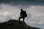
Then the serious things started : an impressive steep climb at the foot of Le Grand Charnier. Probably 600 m elevation gain in less than 1 km. A marmot seemed to be guarding the entrance to that physical challenge, or maybe it was just wishing me good luck. The first part was steep, but rarely required scrambling. But then rocks made their appearance and scrambling was necessary. It wasn't technical rock scrambling at all, but with the altitude and the steepness, it's physical. I wished I hadn't skipped breakfast. Finally the summit cross was in sight. And then the views opened : a good number of peaks near Mont Blanc seemed to shine, although with the gray weather and the heavy winds, it was more intimidating than warmingly beautiful. I tried to identify all the peaks, but I'm still new in the Alps, so appart from Mont Blanc I couldn't recognize much.
The way back was hard as well, because of the slippery gravel, and a wrong foot got me sliding down the grassy slopes for about 15 meters with no control... I was lucky the slope was gentle on that side, and that no rock hurt me. The rain started to fall, despite the forecast predicting there wouldn't be any, and the views started to clog up. It was then a good idea that I opted for the alternative track through the forest, full of blueberry bushes, unfortunately only in flower and not bearing any fruits yet. I decided not to stop for eating my lunch, so it means I did the whole 7h on an empty stomach. I felt dizzy at times, and will definitely not skip breakfast the next time.
This walk is probably in the top3 of my physical challenges, with a dehydration episode in Croajingolong, and a bad chafing episode + tendinitis at the Razorback in the Aussie Alps, but the views and the befriending of that marmot (which are usually very shy) made it definitely worth it. 1000+ m elevation gain walks in Australia are pretty rare (the most famous being Mount Bogong), but here most 5h+ walks have that type of elevation gain, and lots of vertiginous narrow tracks. Bushwalkers beware.
Le Grand Charnier, 2561 m
Forum rules
Posting large/multiple images in this forum is OK. Please start topic titles with the name of the location or track.
For topics focussed on photos rather than the trip, please consider posting in the 'Gallery' forum instead.
This forum is for posting information about trips you have done, not for requesting information about a track or area.
5 posts
• Page 1 of 1
Le Grand Charnier, 2561 m
![]() by Hallu » Mon 21 Jul, 2014 7:46 pm
by Hallu » Mon 21 Jul, 2014 7:46 pm
- Attachments
-
-
- The objective is the highest point on the left, pretty daunting
-
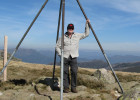
- G'day, mate
-
- Panoramic view from the top
-
Last edited by Hallu on Mon 21 Jul, 2014 9:58 pm, edited 1 time in total.
- Hallu
- Athrotaxis selaginoides

- Posts: 1833
- Joined: Fri 28 Sep, 2012 11:19 am
- Location: Grenoble
- Region: Other Country
Re: Le Grand Charnier, 2561 m
![]() by Travis22 » Mon 21 Jul, 2014 9:04 pm
by Travis22 » Mon 21 Jul, 2014 9:04 pm
Amazing landscape once again Hallu.
Travis.
Travis.
-

Travis22 - Phyllocladus aspleniifolius

- Posts: 685
- Joined: Thu 15 Nov, 2012 7:11 pm
- Region: Victoria
- Gender: Male
Re: Le Grand Charnier, 2561 m
![]() by icefest » Mon 21 Jul, 2014 9:56 pm
by icefest » Mon 21 Jul, 2014 9:56 pm
Incredible story and landscapes.
Thanks for sharing!
Thanks for sharing!
Men wanted for hazardous journey. Low wages, bitter cold, long hours of complete darkness. Safe return doubtful.
-

icefest - Lagarostrobos franklinii

- Posts: 4517
- Joined: Fri 27 May, 2011 11:19 pm
- Location: www.canyoninginvictoria.org
- Region: Victoria
Re: Le Grand Charnier, 2561 m
![]() by naturelover » Mon 04 Aug, 2014 9:37 pm
by naturelover » Mon 04 Aug, 2014 9:37 pm
Loved the pics and story. Thanks. You're so lucky to have such ready access to that magic area, but I know those narrow paths with their slant and deathly drop to the side that you refer to all too well - they terrify me. Give me rocks or a via ferrata with something to hang on to any day.
Where did you begin the walk (i.e., how does one get to the start)?
Where did you begin the walk (i.e., how does one get to the start)?
-
naturelover - Athrotaxis cupressoides

- Posts: 285
- Joined: Mon 23 Apr, 2012 7:07 pm
- Region: Tasmania
- Gender: Female
Re: Le Grand Charnier, 2561 m
![]() by neilmny » Tue 05 Aug, 2014 6:31 pm
by neilmny » Tue 05 Aug, 2014 6:31 pm
Thanks for posting Hallu...beautiful views.
-
neilmny - Lagarostrobos franklinii
- Posts: 2576
- Joined: Fri 03 Aug, 2012 11:19 am
- Region: Victoria
- Gender: Male
5 posts
• Page 1 of 1
Return to International Trip Reports & Track Notes
Who is online
Users browsing this forum: No registered users and 2 guests