Forum rules
Posting large/multiple images in this forum is OK. Please start topic titles with the name of the location or track.For topics focussed on photos rather than the trip, please consider posting in the 'Gallery' forum instead.
This forum is for posting information about trips you have done, not for requesting information about a track or area.
The Jaithmathangs
Thu 09 Jun, 2011 11:08 am
Mt Jaithmathang (pronounced Yit-ma-thang, or,as I heard someone say, Eat My Tongue) is the main peak in a series of rocky peaks - The Jaithmathangs - in the Alpine National Park, not far from Falls Creek. Formerly known as the Niggerheads, the name was changed in January 2009 to recognise the connection between Victoria’s Aboriginal people and the land. The Jaithmathang, along with the Bidawel, Monero-Ngarigo, Gunaikurnai, Taungurung, Mitambuta, Ngarigu-Currawong, Dhudhuroa, Waywurru and Wurrundjeri peoples, are recognised as Traditional Owners of the alpine country.
No-one seems sure where the name Niggerhead came from. As we were descending from Mt Jaithmathang itself, a hiker climbing up told me that the name came from some Aboriginals, told to early settlers, because from a distance the outcrops along the range look like the heads of black fellas. Niggerheads is also a sailing term from the days of the slave trade used to describe reefs of black rock that lie just below the surface, as well as the bollards capped with iron (ex-canon) that are found on many piers. Wherever the name came from, it is not quite suitable in the 21st century.
The walk started at Pretty Valley Pondage, not far from Falls Creek. The weather was fine and there was only about 20 cars plus a couple of mini-buses parked there (it was Easter). The pondage is the end of the road with a locked gate restricting access along the Fainter Fire Trail to walkers only. We filled out the intentions book and followed another party of walkers up the hill through open alpine meadows towards Tawonga Huts, some four and half kilometres away.
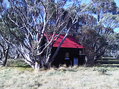
Tawonga Huts and their associated cattle yards were built when cattle grazing was still permitted in the national park. Cattle grazing of course has been stopped since 2006 except for ‘fuel reduction research’. The hut area was crowded with walkers and mountain bikers having lunch. After a quick bite ourselves, we continued along the fire track, which skirts the range’s eastern flank towards The Fainters and Bogong Jack beyond that. The fire trail deteriorated – it would be difficult to get a vehicle along it – but made for pleasant walking. A few groups passed us going the other way having spent a long day hiking out to The Fainters and back or having hiked in from Bogong Jacks.
The Little Plain – a broad saddle between The Fainters and the Jaithmathings – marked the end of the day’s walking and our camp for the night under dead (burnt) snowgums and piles of what I assume was old brumby poo. Water came from a stream running through the open fields and after setting up camp we ate dinner and watched the sun set. Given the number of vehicles and people we passed I was surprised that we managed to camp alone.
Some maps show a track from Little Plain to Mount Jaithmathang across the top of the range. It doesn’t exist. Navigation, however, isn’t difficult and we wandered easily across the grasslands, through some boggy bits, and picked our way from peak to peak along the range for a lovely morning’s walking to the summit of Mount Jaithmathang and our first encounter with other humans (the peak was a busy little lunch stop for half a dozen or so other hikers). From here a track that occasionally resembled a creek returned us to Tawonga Huts and the Fainter Fire Trail, which we then followed back to the start of the walk.
It was a good, easy overnight walk, with no big climbs. We used Bogong Alpine Area Outdoor Recreation Guide Map published by Spatial Vision for navigation. The walk is sort of described in Glenn van der Knijff’s Bushwalks in the Victorian Alps (day 2 of walk 7 in that book).
I have posted some photos on youtube.
http://youtu.be/ZJygpmiYQnI
I also have a blog of this and other trip reports.
http://ian-folly.blogspot.com/
No-one seems sure where the name Niggerhead came from. As we were descending from Mt Jaithmathang itself, a hiker climbing up told me that the name came from some Aboriginals, told to early settlers, because from a distance the outcrops along the range look like the heads of black fellas. Niggerheads is also a sailing term from the days of the slave trade used to describe reefs of black rock that lie just below the surface, as well as the bollards capped with iron (ex-canon) that are found on many piers. Wherever the name came from, it is not quite suitable in the 21st century.
The walk started at Pretty Valley Pondage, not far from Falls Creek. The weather was fine and there was only about 20 cars plus a couple of mini-buses parked there (it was Easter). The pondage is the end of the road with a locked gate restricting access along the Fainter Fire Trail to walkers only. We filled out the intentions book and followed another party of walkers up the hill through open alpine meadows towards Tawonga Huts, some four and half kilometres away.
Tawonga Huts and their associated cattle yards were built when cattle grazing was still permitted in the national park. Cattle grazing of course has been stopped since 2006 except for ‘fuel reduction research’. The hut area was crowded with walkers and mountain bikers having lunch. After a quick bite ourselves, we continued along the fire track, which skirts the range’s eastern flank towards The Fainters and Bogong Jack beyond that. The fire trail deteriorated – it would be difficult to get a vehicle along it – but made for pleasant walking. A few groups passed us going the other way having spent a long day hiking out to The Fainters and back or having hiked in from Bogong Jacks.
The Little Plain – a broad saddle between The Fainters and the Jaithmathings – marked the end of the day’s walking and our camp for the night under dead (burnt) snowgums and piles of what I assume was old brumby poo. Water came from a stream running through the open fields and after setting up camp we ate dinner and watched the sun set. Given the number of vehicles and people we passed I was surprised that we managed to camp alone.
Some maps show a track from Little Plain to Mount Jaithmathang across the top of the range. It doesn’t exist. Navigation, however, isn’t difficult and we wandered easily across the grasslands, through some boggy bits, and picked our way from peak to peak along the range for a lovely morning’s walking to the summit of Mount Jaithmathang and our first encounter with other humans (the peak was a busy little lunch stop for half a dozen or so other hikers). From here a track that occasionally resembled a creek returned us to Tawonga Huts and the Fainter Fire Trail, which we then followed back to the start of the walk.
It was a good, easy overnight walk, with no big climbs. We used Bogong Alpine Area Outdoor Recreation Guide Map published by Spatial Vision for navigation. The walk is sort of described in Glenn van der Knijff’s Bushwalks in the Victorian Alps (day 2 of walk 7 in that book).
I have posted some photos on youtube.
http://youtu.be/ZJygpmiYQnI
I also have a blog of this and other trip reports.
http://ian-folly.blogspot.com/
Re: The Jaithmathangs
Thu 09 Jun, 2011 7:16 pm
You didn't go up to the Fainters?
Re: The Jaithmathangs
Thu 09 Jun, 2011 8:36 pm
The original plan was to camp below the Fainters but we started late and walked slowly and just weren't gunna make it. 
Re: The Jaithmathangs
Thu 09 Jun, 2011 8:51 pm
Pity.
I've been meaning to do that ridge next time I get out there. Probably next summer at this rate.
I've been meaning to do that ridge next time I get out there. Probably next summer at this rate.
Re: The Jaithmathangs
Wed 22 Jun, 2011 2:30 pm
Great pics, I was guiding a group around the high plains myself over Easter, three days of brilliant weather and blue skies.
The walk along the ridge is a classic. Start at Tawonga huts and follow the track up to the summit, then nav your way across the ridgeline from peak to peak. There are more beautiful campsites up there before Little Plain too and a fun finish is to work you way up to the summit of Mt Fainter South before returning to Tawonga Huts via the fire trail. This makes a good day walk from Tawonga though would take longer with full packs.
I was so impressed with this terrain that we ran alpineSAR winter training here 2 years ago and it proved a brilliant venue and proved the worth of snowshoes as opposed to skis in treed, rocky and technical terrain such as this.
Thanks for the post, I enjoyed the memories your words and pics brought back, love this western outlier of the high plains.
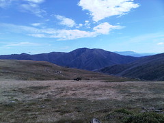
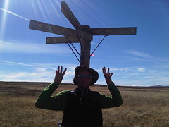
BTW here's a few pics fro our walking over the high plains over Easter:
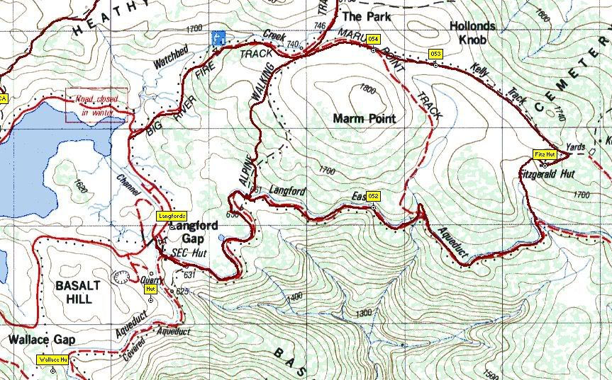
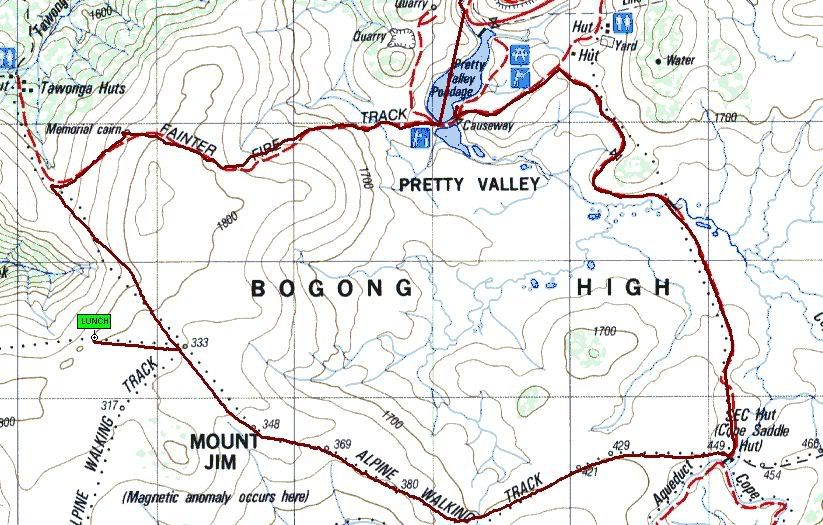
Here are the GPS plots of our walk loops:
1. Heathy Spur to Mt Nelse via Edmonsons and back via Johnstons and Watchbed Creek
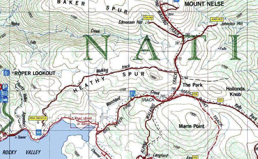
2. Langford Gap to Fitzgeralds Huit via Langford East aqueduct trail and a short off track section to the hut, then back to Langford Gap via the pole line to the Park and the AAWT down the west side of Marm Point back to the aqueduct trail
3. Southern BHP Loop
Pretty Valley to Pole 333 via Ben Cooper Memorial & the pole line then follow the pole line baclk past Mt Jim (say g'day to the brumbies) & Mt Bundara to Cope Saddle, then back to the road intersection on the way down to PV
The walk along the ridge is a classic. Start at Tawonga huts and follow the track up to the summit, then nav your way across the ridgeline from peak to peak. There are more beautiful campsites up there before Little Plain too and a fun finish is to work you way up to the summit of Mt Fainter South before returning to Tawonga Huts via the fire trail. This makes a good day walk from Tawonga though would take longer with full packs.
I was so impressed with this terrain that we ran alpineSAR winter training here 2 years ago and it proved a brilliant venue and proved the worth of snowshoes as opposed to skis in treed, rocky and technical terrain such as this.
Thanks for the post, I enjoyed the memories your words and pics brought back, love this western outlier of the high plains.
BTW here's a few pics fro our walking over the high plains over Easter:
Here are the GPS plots of our walk loops:
1. Heathy Spur to Mt Nelse via Edmonsons and back via Johnstons and Watchbed Creek
2. Langford Gap to Fitzgeralds Huit via Langford East aqueduct trail and a short off track section to the hut, then back to Langford Gap via the pole line to the Park and the AAWT down the west side of Marm Point back to the aqueduct trail
3. Southern BHP Loop
Pretty Valley to Pole 333 via Ben Cooper Memorial & the pole line then follow the pole line baclk past Mt Jim (say g'day to the brumbies) & Mt Bundara to Cope Saddle, then back to the road intersection on the way down to PV
© Bushwalk Australia and contributors 2007-2013.