Having completed a variation on the circuit around Mt Howitt, the Crosscut Saw, Mt Speculation, the Viking, and the Wonnangatta River, I will not write about the overall circuit as this has been done at length by many others. Instead, I will write about an untracked route.
Prior to heading to the area, I had read suggestions and reports that a track once lead up an un-named spur from the Wonnangatta River to Macalister Spring. These assertions were little more than rumours, and wanting to avoid the drudgery of Zeka Spur Track I decided that I would take this route, track or no track.
Prior to reaching the Wonnangatta River, the route from the South Viking was rough and heavily overgrown with regrowth. The majority of the route was trackless but nonetheless straightforward from a navigational perspective: essentially it’s just a matter of following the spur downhill. While the easiest route would be to simply ride the spine of the spur downhill, it is necessary at most times to hand-rail the spine at varying distances to find a path of least resistance through the regrowth.
Most maps show a track following the river’s course that eventually leads up to Catherine Saddle. While I did not seek the top of the trail when I passed through Catherine Saddle earlier the same day and thus cannot state whether it exists higher, I can confirm that it does not exist anymore at the lower levels. With dense vegetation on both banks, I embraced the natural highway of the river and went feet-wet. There were times when evidence of a previous track was seen and followed, but these disappeared into walls of vegetation just as soon as they had appeared out of it. Most of these remnants started and finished corresponding with deeper sections of the river, and I suspect they may now be ‘maintained’ by the deer (that populate the area) as they seek to avoid the deep water. I waded my way up-stream for 4.4km.
 05.pdf
- (2.81 MiB) Downloaded 627 times
The day was coming to a close as I made my way to the base of the un-named spur, and I began contemplating either a squashed night in a confined area near the river or a night on an incline on the spur. I was fortunate to find a perfectly flat and suitably sized area that was both mostly clear of vegetation and immediately above the river bank at the very base of the spur (at 683m elevation). Some long-since cut tree trunks next to it further suggest that the track once existed and perhaps others had used this spot to camp. The location was most convenient; however the proximity to the river and the afternoon’s rains guaranteed plentiful mosquitoes. Thankfully they disappeared shortly after darkness arrived.
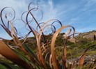
The following morning I commenced my search for a track leading up the spur. Vegetation was as dense as it could be and simply had to be pushed through manually and very slowly. No evidence of a track was found on the lower parts of the spur, and once the vegetation thinned (relatively) above 800m the going was aided in some places by conveniently located and orientated deer tracks.
Navigation up the spur is simple. So long as the spur is followed and the going is steeply uphill, the way is correct. Growing steeper as elevation is gained, virtually all the hard work is over once the 1427m spot-height is reached (GR 717 869). It took me 2:35 to cover the 3.6km distance and 744m elevation gain to this point.
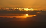
After some short respite in steepness, the 1490 spot-height (GR 715 866) is reached and a small ledge provides clear and expansive views over the Terrible Hollow from the Devil’s Staircase to the Crosscut Saw and round to the spur down from the South Viking to the river.
A small demolished cairn graced the ledge and clearly others have enjoyed this view previously. I suspect (however) that any recent visitors have probably come down from Macalister Springs rather than up from the river. This is because following a short area of further dense vegetation over rocks and dead trees, a faint track emerged. There is no doubt that the areas between the 1427 and 1490 spot-heights would be great places to spend a night (and carrying water down from the spring would be negligible in terms of effort). Once atop and among the snow-gums, the route to the spring is self-evident.
In summary, this un-named spur is not for everyone. It took me 3:42 to cover the 4.8km distance and 966m elevation gain to the top of the spur. To provide comparison, the route up Helicopter Spur from the Howqua River (GR 610 857) to the junction with the AAWT (GR 643 830) is 6.2km with 814m elevation gain, and this took me 2:20. The spur is rough, there is no track, and the vegetation is dense or worse.
One last thing: wear pants or high gaiters. I wore ankle gaiters.