Total ascent: 4652 m
Total descent: 4652 m
Total time: 26:30
The shoulder season can be a surprise when it comes to conditions, and this quick three-day circuit around Mt Bogong and Mt Wills lived up to this expectation in a positive fashion. The days prior to the trip were characterised by weather reports of a cold blast and warnings of up to 60cm of snowfall in the High Country, followed by a few days of fine weather. This was an accurate forecast in the most part, although I am not sure that close to 60cm of snow fell anywhere in the vicinity.
Day One (14 May 2015)
Mountain Creek Campsite – Staircase Spur – Mt Bogong – Quartz Ridge – Timms Spur – Roper’s Hut
Distance: 29.4 km
Ascent: 2311 m
Descent: 1187 m
Time: 7:26
After driving from Melbourne the previous afternoon and camping at Mountain Creek Campsite, I set off at just on 0730. It was 3oC and, although solidly grey, the clouds were higher than Mountain Creek Campsite (~600m) but not as high as Mt Bogong.
The route up Staircase Spur was without surprises as I moved up under the protection afforded by being below the treeline. The first signs of snow were encountered slightly below Bivouac Hut at around 1400m elevation, yet at this stage, it was just a dusting.
Once above the treeline, snow cover was complete and ice dominated most exposed rocks. By the time I moved past Castor and Pollux Outcrops, I had reached the clouds, the wind was increasing, and snow depth was around 30cm. Visibility was low as I made it to the junction with the main shoulder leading to the summit. The summit cairn was not at all visible at this point.
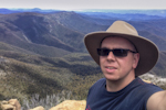
The climb up Staircase Spur necessitated only a long sleeve technical t-shirt, an over-shirt, and softshell pants. Once I made it to the summit after 2:47, the wind was fierce and gloves and jacket became essential. I sheltered in protection on the northern side of the cairn as I donned the extra layers.
Clouds completely shrouded the summit and surrounding areas, yet the wind kept them moving and allowed glimpses to the High Plains through brief gaps. They were visibly covered only at the top with snow.
I would be passing over Mt Bogong again in two days at which time the forecast was for better conditions, so I did not linger long on the summit. Dropping down through Black Saddle and skirting Hooker Plateau I made my way towards Quartz Ridge. The wind remained fierce and the snow remained between 20 – 30 cm deep on the southern faces. Fortunately the going was easy with the snow being well compacted albeit slippery in places. At around 1750m the snow began to slowly thin as I dropped below the clouds again. A short while after I was able to remove my jacket and gloves.
The route down Quartz Ridge was quick and the track was in most parts unobstructed. I reached Bogong Creek Saddle (~1320m) at just on noon after 4:46. The crossing of Big River was not quite as cold as I expected it would be, and then following the fire-track up Timms Spur was fast and easy-going. By the time I had regained most of the lost elevation at Timms Lookout (1800m) and the route ahead was levelling out again, it was time once more for the jacket and gloves to return. It was at this point that again the snow completely covered the ground to around 15cm of depth, and iced-over pools of water dominated the ruts of the fire-track. Fortunately the wind had reduced somewhat.
I reached the junction of Timms Spur and Duane Spur at 1440, 7:09 after starting that morning. From here it was an easy stroll down to the vicinity of Roper’s Hut and my night location.
Reaching my destination at just on 1500 gave me a good few hours of daylight in which to relax and pick the best spot to set camp. I was impressed by the rebuild of Roper’s Hut in the original style, and the surrounding area has bounced back after the fires that destroyed it in 2003. After setting camp, enjoying a hot drink, taking a stroll around the area, and having dinner, I was under my tarp by 1830 for restful night.
The night was breezy, and perhaps outside of the protection provided by the surrounding light vegetation would have been stronger. Clouds remained well past nightfall.
Day two (15 May 2015)
Roper’s Hut – Timmins Lookout – Big River – Frog Track – Mt Wills
Distance: 26.1 km
Ascent: 1302 m
Descent: 1290 m
Time: 10:37
Waking early after an equally early night, I was greeted by a clear sky soon to be graced with a rewarding sun. I was walking by just after 0730 and although cold, the morning was shaping to be a superbly pleasant day.
I retraced my steps of the previous day back to the junction of Duane and Timms Spurs, then rolled over the small knoll to the northeast of Warby Corner. All areas above 1780m remained under snow, however I expected that the day’s sun and forecast temperature of up to 4oC would reduce the cover over low vegetation.
From the small knoll, I surveyed my route ahead and commenced my decent towards the saddle formerly occupied by Batty’s Hut (marked on some maps as Betty’s Hut), also destroyed in the 2003 fires. Once below around 1650m, the vegetation was thick and no definitive remains of the former track to the Batty’s Hut site were identified. Navigation was tree-to-tree on compass bearings, usually through dense scrub, although at times fortuitously aligned animal tracks could be taken for short distances up to 30 or so metres. The animal tracks never cleared the route; they just thinned the vegetation slightly.
At approximately 1115, after 3:45, I reached Timmins Lookout. Pausing shortly to survey the available routes down to Big River, I decided the initial drop would be best made to the southeast rather than the northeast as originally planned. This would increase distance and force me to cross numerous re-entrants as I corrected the route northward once lower, but the initial drop from the lookout seemed safer.
The drop seemed safer, maybe not entirely safe in all weather conditions. Fortunately for me, the north facing route had already had a morning’s worth of direct sunlight and was free of frost. It remained nonetheless steep and unstable underfoot. Going was slow, deliberate, and technically satisfying.
Once down from the steepest and rocky sections, and having dropped approximately 300m of elevation in around 700m of travel, I commenced the correction over repeated re-entrants. The vegetation was significantly denser that that encountered around the Batty’s Hut site, and also particularly more established with stronger, more horizontal, and more overlapping branches. Navigation was again from tree-to-tree as picked on the compass bearing. I aimed for two distinct dog-legs in the river’s course that were south of the river’s junction with Frog Track on the far bank in order to ensure I could then follow the river up-stream and find the junction. It took 2:10 to cover the 2.1km from the point of my correction northwards to Big River.
I was expecting Frog Track at Big River to potentially be difficult to find, however this was not the case. Identifying on the map that it was on the almost perfectly north-south alignment of the river, and almost directly opposite a creek confluence from the west, I located it with ease and was surprised to find it clear and without an overgrown junction with the river. By aiming-off and deliberately needing to follow the river upstream for a short distance, I was able to keep an eye out for a suitable crossing point. Conveniently, I found one almost directly upon the junction. Crossing was colder than the previous day, past the knees in parts, and forcefully firm. I had previously noted that this location had been used by the Murray-Darling Basin Authority to monitor water conditions in 2009 and 2010, and perhaps it is still used for this purpose (as vehicle access would be possible).
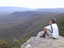
Ascending from the river (920m) was not particularly steep but was rather constant and gentle. Frog Track was in good condition for a vehicle track, although in parts it is not particularly pretty due to being in a state forest rather than a national park. This point notwithstanding, there are several nice views southward over Glen Valley along the route.
One of the reasons for heading towards Mt Wills was to scout some locations for a food cache for the AAWT. I headed north from Big River Saddle for this reason. After returning to the saddle, I hit the steep uphill towards Mt Wills. The lower parts of this climb were taxing on tired legs that had been fatigued by the slow and rhythmless push through vegetation towards Big River earlier in the day. At this stage, the sun was getting quite low in the sky and I estimated my arrival at Mt Wills would be almost exactly at last light. Pushing on, and appreciating the reduced gradient further up, I reached Mt Wills just after last light after 10:37 of walking (and pushing through vegetation). Setting up camp under torchlight, I enjoyed a warm feed and a hot drink under the clearest of clear night skies, and was in my bag and bivy quite soon.