On Tuesday I set off for an overnight hike of the Crinoline and Mt Tamboritha Circuit, starting and finishing at the school camp site on Tamboritha Rd.
The weather was fantastic and I had a great time. It was my first solo overnight trip.
The track heading up to the top of the Crinoline was really easy to follow I was expecting more climbing over rocks but it didnt really happen until the top of the Crinoline and even then there wasn't much.
Coming down off the Crinoline towards Long Hill was a little harder to follow the trail and a few times I ended up going parallel or slightly off track. It was always easy to make sure you were always going in the right direction though.
Looking at my GPS data of where I walked vs where the track was it (the north west corner and either side of Long Hill) was definitely the hardest section of the hike to stay on the path.
I stayed overnight at the rock shelter in a bivy and it was amazing. Im glad I didnt take a tent.
Day 1 I started at about 10am and made it to the shelter at about 6pm I think
The next day started off really foggy but soon I had views looking over low level cloud cover and at mountain peaks which was cool.
The track between the rock shelter and Mt Tamboritha was good with a large section along the northern ridge being a 4x4 track before turning south.
I didnt get much of a view from Mt Tamboritha due to the cloud unfortunately.
The track was on and off again for a little on the way down before it was much better defined for the last few kms down.
Day 2 I started at 7am and was back at the car at 1.30pm
I carried 2 days of water (10L) with me. There was no water in Long Hill Creek. The dam at Little Tamboritha was just a muddy puddle however the dam a little further down still had water. I still had a bit left when I got back.
Saw a couple of snakes on day 2 but nothing alarming.
If your going to do this hike I recommend wearing long pants or high gaiters. Lots of knee high scrub to push through.
Total distance was 34.7km with a couple of side detours and 1804m ascent and descent
Trip Report : Crinoline - Mt Tamboritha Circuit
Forum rules
Posting large/multiple images in this forum is OK. Please start topic titles with the name of the location or track.
For topics focussed on photos rather than the trip, please consider posting in the 'Gallery' forum instead.
This forum is for posting information about trips you have done, not for requesting information about a track or area.
16 posts
• Page 1 of 1
Trip Report : Crinoline - Mt Tamboritha Circuit
![]() by Saintpaul » Fri 12 Mar, 2021 11:06 am
by Saintpaul » Fri 12 Mar, 2021 11:06 am
- Saintpaul
- Nothofagus gunnii

- Posts: 28
- Joined: Wed 03 Feb, 2021 11:02 am
- Region: Victoria
- Gender: Male
Re: Trip Report : Crinoline - Mt Tamboritha Circuit
![]() by CraigVIC » Fri 12 Mar, 2021 11:22 am
by CraigVIC » Fri 12 Mar, 2021 11:22 am
Sounds great SP, any pix of your camp etc?
- CraigVIC
- Phyllocladus aspleniifolius

- Posts: 584
- Joined: Tue 24 Oct, 2017 6:20 pm
- Region: Victoria
Re: Trip Report : Crinoline - Mt Tamboritha Circuit
![]() by Baeng72 » Fri 12 Mar, 2021 11:45 am
by Baeng72 » Fri 12 Mar, 2021 11:45 am
Nice report.
10 liters of water? That'll get you fit.
10 liters of water? That'll get you fit.
- Baeng72
- Athrotaxis selaginoides

- Posts: 1057
- Joined: Wed 07 Aug, 2019 2:29 pm
- Region: Victoria
- Gender: Male
Re: Trip Report : Crinoline - Mt Tamboritha Circuit
![]() by paidal_chalne_vala » Fri 12 Mar, 2021 12:47 pm
by paidal_chalne_vala » Fri 12 Mar, 2021 12:47 pm
Thanks for the trip report.
You did well for someone just getting into this pastime as a solo overnight hiker.
I did this hike in May 2012 using a car shuttle with one car at Tamboritha Saddle and the other at Breakfast Creek campsite.. It was raining a lot that weekend, there was snow on the higher peaks and the creek on Long Hill was flowing.
Carting 10 L. of water does
not sound like fun to me.
Generally October is a good time to walk this route when water will be flowing in the creek on Long Hill and the water fall off the escarpment is quite a spectacle. From the Rock Shelter to the Long Hill Camp site and on to the edge of Long Hill going anti clockwise you should keep the escarpment on your right but it does involves some bush bashing and navigation.
Last edited by paidal_chalne_vala on Fri 12 Mar, 2021 10:26 pm, edited 1 time in total.
- paidal_chalne_vala
- Lagarostrobos franklinii

- Posts: 2469
- Joined: Sun 22 Jan, 2012 10:30 pm
- ASSOCIATED ORGANISATIONS: VNPA.BTAC.Friends of Baw Baw.Mt.Bogong Club.
- Region: Victoria
- Gender: Male
Re: Trip Report : Crinoline - Mt Tamboritha Circuit
![]() by Saintpaul » Fri 12 Mar, 2021 1:53 pm
by Saintpaul » Fri 12 Mar, 2021 1:53 pm
Baeng72 wrote:Nice report.
10 liters of water? That'll get you fit.
I was travelling fairly light. Total weight was 21kg and it only got lighter as I went. Lol
- Saintpaul
- Nothofagus gunnii
- Posts: 28
- Joined: Wed 03 Feb, 2021 11:02 am
- Region: Victoria
- Gender: Male
Re: Trip Report : Crinoline - Mt Tamboritha Circuit
![]() by Saintpaul » Fri 12 Mar, 2021 1:54 pm
by Saintpaul » Fri 12 Mar, 2021 1:54 pm
CraigVIC wrote:Sounds great SP, any pix of your camp etc?
I did take some photos. I just have to figure out how to post them.
- Saintpaul
- Nothofagus gunnii
- Posts: 28
- Joined: Wed 03 Feb, 2021 11:02 am
- Region: Victoria
- Gender: Male
Re: Trip Report : Crinoline - Mt Tamboritha Circuit
![]() by bigkev » Fri 12 Mar, 2021 4:54 pm
by bigkev » Fri 12 Mar, 2021 4:54 pm
Thanks for the report Saint Paul... very informative.
-
bigkev - Athrotaxis cupressoides

- Posts: 444
- Joined: Sat 30 Jun, 2012 6:44 pm
- Region: Victoria
- Gender: Male
Re: Trip Report : Crinoline - Mt Tamboritha Circuit
![]() by paidal_chalne_vala » Sat 13 Mar, 2021 8:12 am
by paidal_chalne_vala » Sat 13 Mar, 2021 8:12 am
I have never been able to work out how to post photos on this website. The WWW Ski forum is much simpler to operate so my trip reports are all there now.
- paidal_chalne_vala
- Lagarostrobos franklinii
- Posts: 2469
- Joined: Sun 22 Jan, 2012 10:30 pm
- ASSOCIATED ORGANISATIONS: VNPA.BTAC.Friends of Baw Baw.Mt.Bogong Club.
- Region: Victoria
- Gender: Male
Re: Trip Report : Crinoline - Mt Tamboritha Circuit
![]() by CraigVIC » Sat 13 Mar, 2021 8:38 am
by CraigVIC » Sat 13 Mar, 2021 8:38 am
Saintpaul wrote:CraigVIC wrote:Sounds great SP, any pix of your camp etc?
I did take some photos. I just have to figure out how to post them.
If you are posting from your phone and your pictures are there too then just use the choose file button and then the add the file button on the post a reply page. If the pictures are too big and you get an error you can make them smaller using an app like Resizer (android) before choosing them.
- CraigVIC
- Phyllocladus aspleniifolius
- Posts: 584
- Joined: Tue 24 Oct, 2017 6:20 pm
- Region: Victoria
Re: Trip Report : Crinoline - Mt Tamboritha Circuit
![]() by Saintpaul » Sat 13 Mar, 2021 9:24 am
by Saintpaul » Sat 13 Mar, 2021 9:24 am
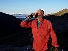
Lets give this a try

The view south from The Crinoline

Looking back at the Crinoline

One of the Many views

The Rock Shelter

Camp for the night

Morning View from the Rock Shelter

Nothing but clouds from the top of Mt Tamboritha
The view south from The Crinoline
Looking back at the Crinoline
One of the Many views
The Rock Shelter
Camp for the night
Morning View from the Rock Shelter
Nothing but clouds from the top of Mt Tamboritha
- Saintpaul
- Nothofagus gunnii
- Posts: 28
- Joined: Wed 03 Feb, 2021 11:02 am
- Region: Victoria
- Gender: Male
Re: Trip Report : Crinoline - Mt Tamboritha Circuit
![]() by CraigVIC » Sat 13 Mar, 2021 10:05 am
by CraigVIC » Sat 13 Mar, 2021 10:05 am
Looks great, thanks for the report.
- CraigVIC
- Phyllocladus aspleniifolius
- Posts: 584
- Joined: Tue 24 Oct, 2017 6:20 pm
- Region: Victoria
Re: Trip Report : Crinoline - Mt Tamboritha Circuit
![]() by Baeng72 » Sat 13 Mar, 2021 2:32 pm
by Baeng72 » Sat 13 Mar, 2021 2:32 pm
Nice photos. Now I know why they call it the Crinoline.

- Baeng72
- Athrotaxis selaginoides
- Posts: 1057
- Joined: Wed 07 Aug, 2019 2:29 pm
- Region: Victoria
- Gender: Male
Re: Trip Report : Crinoline - Mt Tamboritha Circuit
![]() by paidal_chalne_vala » Sat 13 Mar, 2021 3:18 pm
by paidal_chalne_vala » Sat 13 Mar, 2021 3:18 pm
Nice Photos. I love that part of Victoria  .
.
- paidal_chalne_vala
- Lagarostrobos franklinii
- Posts: 2469
- Joined: Sun 22 Jan, 2012 10:30 pm
- ASSOCIATED ORGANISATIONS: VNPA.BTAC.Friends of Baw Baw.Mt.Bogong Club.
- Region: Victoria
- Gender: Male
Re: Trip Report : Crinoline - Mt Tamboritha Circuit
![]() by Avatar » Sat 13 Mar, 2021 8:36 pm
by Avatar » Sat 13 Mar, 2021 8:36 pm
How to upload images to your reply:
Use the Upload Attachment tab at bottom of Post a Reply to upload the image(s) then click Add the file then position the cursor and click Place inline:
Use the Upload Attachment tab at bottom of Post a Reply to upload the image(s) then click Add the file then position the cursor and click Place inline:
- Capture.JPG (24.11 KiB) Viewed 18202 times
- Capture2.JPG (15.17 KiB) Viewed 18202 times
-

Avatar - Athrotaxis cupressoides
- Posts: 279
- Joined: Sun 07 Jul, 2013 5:21 pm
- Location: NE Melbourne
- Region: Victoria
Re: Trip Report : Crinoline - Mt Tamboritha Circuit
![]() by oldsalt671 » Mon 31 Oct, 2022 5:41 pm
by oldsalt671 » Mon 31 Oct, 2022 5:41 pm
We completed this circuit clockwise over the first two days of the Cup Weekend (Oct 29/30) 2022. Given the floods in Victoria at the time, there was no shortage of water.
Some pics from the trip annotated to reflect the notes below: https://www.flickr.com/gp/62993514@N06/1T7v482Fx0
We used the GPX track from Trail Hiking Australia. For the most part, it is still pretty accurate https://www.trailhiking.com.au/hikes/mount-ligar-and-mount-tamboritha/
Notes as follows:
Day 1
- We drove up Friday night and camped at the site adjacent to the MGS buildings near Breakfast Creek
- We departed at 8:00m from the track sign
- The track up the Crinoline was in good condition. It is a steep climb and certainly got the heart pumping-
- The Long Hill Creek Falls were quite spectacular even from a distance due to the recent rain
- Getting up onto the Crinoline was relatively straightforward. There was a single bench that required a bit of a scramble
- We followed the cairns off the top. There was a bench on the way down that we took our packs off and lowered them down, but nothing too difficult
- Heading down, we found a stone arrow that pointed us to the right, this sets you up for a descent down the scree slope. It is steep but did not require any rock scrambling
-The rocky ridge that leads to the climb up to the falls was very slippery due to the rain as it is covered in lichen and moss.
- Once past the falls, the track climbs up and levels off. There is a large cairn that marks the track into the camps near Long Hill Creek. Someone has also cut a "W" into the tree where the track starts. It was around 1:30 pm when we arrived
- It was raining, so we set up the fly and went down to the creek to get water for a cooked lunch. There was kind of a track down to the creek, but it wasn't very distinct.
- We departed for the rock shelter around 4:00 pm. The track was generally pretty good. We passed lots of good campsites. There was plenty of pink tape to mark the way in some of the thickly wooded sections. Some of the tape looked very new.
- We arrived at the Rock Shelter around 6:00 pm. You need to backtrack 30-40 m from the cairn above the rock shelter and head down. There may be a better way, not sure. There was one guy who had set up a small tent and was camped there.
- From the rock shelter, the track becomes quite rocky, and the vegetation is a bit more scraggly. Quite different to the approach to the Rock Shelter. We were happy to arrive at the camp at the start of the vehicle track up to Mt Tamboritha at around 7 pm. We figured we were done for the day, so set up the tents. Quite rocky so used some large rocks for deadman anchors where we couldn't get pegs in
Day 2
- The next day, we set off at around 8 am, the route climbs from the camp and follows the vehicle track but is quite fast. We passed the next decent campsite ater about 50 minutes and arrived at the Mt Tamboritha turn-off at around 9:30. Reached the summit around 10:00am
- Easy hiking across the top. The only mildly challenging bit in terms of navigation was after the final climb (Knolls 1202 1196 1195). You come to a reasonably open alpine meadow. We followed this down but didn't see a lot of markers. There is a steep drop off to the left, and we ended up traversing around to the right staying at the same elevation, in the open, and avoiding the temptation to bush bash. This route leads us back onto the ridge, and we found a marker at the top of the trail. We started the main descent around 12:15 pm The trail was open and quite clear and well-defined.
- The descent is a thigh burner and a little slower than I expected. We were back at the car around 2:30 pm
Cheers
Nigel
Last edited by oldsalt671 on Tue 01 Nov, 2022 11:06 am, edited 1 time in total.
- oldsalt671
- Nothofagus gunnii
- Posts: 17
- Joined: Tue 15 Mar, 2016 3:39 pm
- ASSOCIATED ORGANISATIONS: The Carnot Group, Scouts Victoria
- Region: Victoria
- Gender: Male
Re: Trip Report : Crinoline - Mt Tamboritha Circuit
![]() by paidal_chalne_vala » Tue 01 Nov, 2022 8:57 am
by paidal_chalne_vala » Tue 01 Nov, 2022 8:57 am
Well done. I will have to trek that particular route in spring in the future. BTAC did some track work on that route in Jan. 2022.
I Liked the photos too.
I Liked the photos too.
- paidal_chalne_vala
- Lagarostrobos franklinii
- Posts: 2469
- Joined: Sun 22 Jan, 2012 10:30 pm
- ASSOCIATED ORGANISATIONS: VNPA.BTAC.Friends of Baw Baw.Mt.Bogong Club.
- Region: Victoria
- Gender: Male
16 posts
• Page 1 of 1
Return to VIC Trip Reports & Track Notes
Who is online
Users browsing this forum: No registered users and 4 guests