The Winburndale Range had grabbed my attention on the satellite images with its series of impressive escarpments running in an almost perfectly straight line. The fact that I’d never even heard of this place — despite it being located just over the Great Dividing Range on the way to Bathurst — only piqued my interest more.
A little research revealed a truly unique place full of contradictions: a mountain range topped with river stones; sub-alpine forests perched among the dry plains of the central west; and a row of conglomerate cliffs bursting out of the earth at a 45 degree angle.
Much of the range falls within Winburndale Nature Reserve. Because the primary aim of the park is the protection of diverse flora and fauna, rather than human recreation, there is very little promotion of the area, with low impact activities like bushwalking all that is allowed.
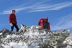
My plan was to traverse as much of the rocky escarpments as possible, including what looked like an impressive knife-edge ridge. I also wanted to check out a couple interesting creeks as they carved deep chasms through the range.
My full trip report, with a large selection of photos, is here: https://fatcanyoners.org/2020/02/26/winburndale/