2015 wasn’t a good year for the outdoors, at least in our family. We got stuck in that proverbial hamster wheel of work, school, concerts, and gigs. So my wife, and a good friend of ours, “L”, planned to take our kids on a 3 day trip visiting some of the main peaks in the Kosciuszko Main Range loop. Normally with a big trip planned, I end up doing a lot of research online and offline, but in this case, the year was so hectic, we were still scrambling putting things together a couple days before the trip. In anycase, the bags were finally packed, the fuel tank filled, and a couple days after Christmas, we hit the road. We were going to spent 3 days in the Kosciuszko National Park and then a few more days at the Jindabyne Big4.
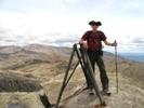
- Walking back down from Mt Twynam
- 01.Twynam.Descent.jpg (282.24 KiB) Viewed 12780 times
We were bringing our mountain bikes with us. L had worked out a deal with a Jindabyne store to hold our bikes while we were walking. Because of the drive, the bike drop, and the desire to start walking by 1300, we left the Melbourne area at 0400. The upside of leaving at this ungodly hour was that the road was mostly traffic free, pretty much all the way to Jindabyne! We ended up having a quick lunch and coffee at Jindabyne, and it was almost 1400 before we actually shouldered our packs and headed up (actually down) the Main Range Track. Any nerves or uncertainty about the trip was gone as we put one foot in front of the other.
We walk a lot with L and his daughters. On this trip only his younger daughter came. She and my older son usually end up setting quite the cracking pace. I’ve called them the “lead pack” in this story. On the climb up to Blue Lake, they were often far ahead and out of sight. They have been “trained” however, to regularly stop and wait for the slower “old folks”.
- Towards Mt Lee and getting very windy and cold
- 02.To.Mt.Lee.jpg (281.6 KiB) Viewed 12780 times
We left our packs somewhere in between Carruthers Peak and the junction to Blue Lake. We headed in a northerly direction, towards the point marked 2136 on the SV Kozzy map. I believe one of the many blogs out there calls this “Mt Dubious”. It was just the first day and we were still fresh. If this had been the third day, I would probably have said forget about this nameless peak! From there, we headed east towards Mt Twynam. Back in April, we had planned a day walk up to Twynam. At Blue Lake, we decided to go up to Carruthers instead because of the heavy fog that day. On this day, I wished that we had gone up to Twynam, because getting there and back was a big detour. In any case, we were soon at the summit trig point taking our obligatory summit photos, and were soon heading back down to our packs.
- Kosciuszko Daisies?
- 03.Kozzy.Daisies.jpg (246.22 KiB) Viewed 12780 times
We picked up our packs and headed up the Main Range Track towards Carruthers Peak. When we walked up to Carruthers in April, it was so foggy that we couldn’t see much more than 10-15 feet in front of us. The only thing we really saw was the summit marker on the peak. Imagine our delight when we saw what we were missing that first time around. The stunning steep slopes viewed from the top of Carruthers is simply magnificent. However, it was now getting quite cold and very windy so we didn’t hang around for long. My little one was also rapidly tiring, so after a few quick photos, we trudged on towards Mt Lee.
It was very, very windy on that final ridge towards Mt Lee, the little one wasn’t enjoying the walk any more, he wanted to go home. But he soldiered on and we were soon on the southwest shoulder of the Mt Lee, which fortunately was relatively sheltered from the winds. By this time, we had about 45 more minutes of sunlight, so the tents were hurriedly stood up, dinner cooked and inhaled, and everyone bundled into their warm sleeping bags. We weren’t more than 50m off the track, it wasn’t ideal. But the sun was almost setting and we planned to move on at first light. My little one spent the night with my wife in my little 1.5 man tent, and after a warm hot chocolate, was soon fast asleep. It was cold that night but fortunately not windy. I normally sleep without a jacket but in the middle of that night I had to put one on. A very bright moon illuminated the tents, and all too soon, the night sky gave way to an ever brightening sky.
- Tents near Mt Lee
- 04.Mt.Lee.jpg (356.03 KiB) Viewed 12780 times
My mom’s family name is Lee, so before the sun rose, I trudged up to the summit to take a few photos. I looked back on our tents and they looked warm and cosy, so I headed back down to boil up water for coffee and breakfast. It may not have been a fitful night’s sleep, but everyone was re-energized and in good spirits, so we were soon heading south on the Main Range Track to Muellers Pass.
I do pride myself on being halfway decent in map reading, so it is still a bitter pill to swallow when writing this paragraph. Maybe the excuse is even the lack of research and planning put into this trip. As we approached the Northcote Pass, we were all taken in with the dramatic beauty of the trail snaking around the side on the mountain pass, and with Lake Albina. My wife’s two main to-dos for this trip was to see Lake Albina and brumbies. So we spent some time taking numerous photos, and just soaking in the views. We were soon at Muellers Pass, thinking about where to pitch the tents, and the walk ahead of us. Those who know this particular region like the back of your hands - yes I can hear you - are undoubtedly saying - dude… you missed Mt Northcote. I photocopied the relevant section of the SV Kozzy Map, listed the Top 12 peaks in order of height on the back, and laminated that as the main map. I have absolutely no idea how I forgot, in fact I didn’t remember till the walk back to the car on the Summit Walk the following day. Other than Carruthers, this might have been the easiest to tick off. It pains me to write this.
- Lake Albina... and I need more Gingko...
- 05.Lake.Albina.jpg (349.63 KiB) Viewed 12780 times