Warren it sounds like quite an adventure. I've been thinking of redoing one of the classic Blue Mts. MTB rides from Katoomba to Mittagong via Yerranderie. It's been years since I did that. Good luck with the training and planning.
K.
A Few Autumn Walks.
Forum rules
Please keep the width of embedded images (using [img] [/img] tags) in this forum to no more than 800 pixels wide (this will avoid them being clipped without notice by most users' window sizes). Attached images can be any resolution so long as the file size is no more than 1 MB (attachments will be displayed by the forums as thumbnails no larger than 800 pixels linked to the full-size image).
Please include a description of the pictures' content so that readers know what they're all about.
For topics focussed on narrative rather than the photos, please consider posting in one of the 'Trip Report' forums instead.
40 posts
• Page 2 of 2 • 1, 2
Re: A Few Autumn Walks.
![]() by kanangra » Sun 23 May, 2010 1:18 pm
by kanangra » Sun 23 May, 2010 1:18 pm
- kanangra
- Athrotaxis selaginoides

- Posts: 1338
- Joined: Sun 25 May, 2008 3:52 pm
Re: A Few Autumn Walks.
![]() by WarrenH » Wed 02 Jun, 2010 11:09 pm
by WarrenH » Wed 02 Jun, 2010 11:09 pm
kanangra wrote: I've been thinking of redoing one of the classic Blue Mts. MTB rides from Katoomba to Mittagong via Yerranderie.
K.
Kanangra, that was what I was trying to do on my second-last trip to Kanangra Boyd and Yerranderie (in late February). Find a crossing at either end of Burragorang. I was thwarted by the huge total no go zone, and the threats of heavy fines everywhere ... $11,000. I though that I could do a reccy on the Scotts Main Range or find a way along the Burns Creek track towards the Jooriland Plateau and the Wanganderry Tablelands and then after crossing the Wollondilly upstream from Burragorang take the eastern shore track until it joins the Sheehy Creek Track. It is possible if one is not caught. If you could do the ride at night the cameras in the bush would'nt see me ... I mean you. The only way I think that trip is possible, legally, is by joining the BNT at Mount Werong, going through to Waiborough and then heading to the Wollondilly River Road then back to Mittagong. It is a good route and bike friendly and no hidden cameras ... I think.
In late February I took these shots on that route. It took me three days and I suffered mild dehydration, the heat was bad. I drank heaps of powdered Gatorade and fresh water, there was plenty of water dripping off every overhang. When I got home I slept for 16 hours straight. I hope that you like the shots.
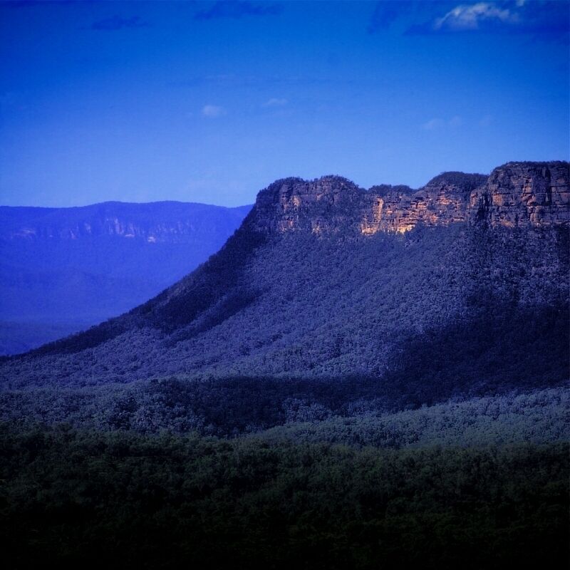
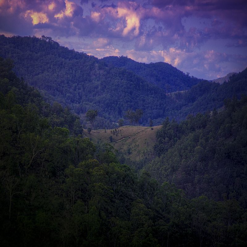
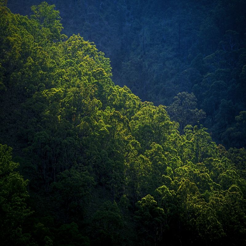
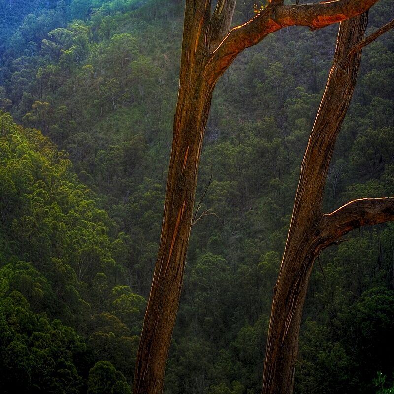
One of the best rides that I've done, but one the hardest, I'm getting too old for this shi(p)t. I'm finding that I walk more than I ride nowadays, but then I always have. I certainly walk up the hills ... why else would a push-bike be called a push-bike?
Warren.
Last edited by WarrenH on Thu 03 Jun, 2010 7:27 pm, edited 2 times in total.
- WarrenH
- Phyllocladus aspleniifolius

- Posts: 991
- Joined: Thu 07 Jan, 2010 6:54 pm
- Region: Australian Capital Territory
Re: A Few Autumn Walks.
![]() by kanangra » Thu 03 Jun, 2010 2:25 pm
by kanangra » Thu 03 Jun, 2010 2:25 pm
Mate I love the shots. Years ago when I was young and reckless we took the road up beside the lake to exit at Picton. It was the best ride I have ever done. We'd left Scotts MR early that morning and ridden via Yerranderie and the sheepwalk to the Wollondilly which we crossed before heading up the lake as the sun was setting. Finally exited via Picton.
There us another way out that is virtually legal but the Woll. xing is difficult. It is from the Wanganderry Tableland off the wombeyan Caves Rd. From the back of there the track descends past an old mine to the river. Once across it leads to the abandoned homestead and sheds of Jooriland. From there a no. of possibilities exist for the route into Yerranderie. One I particularly like is up over Mt Egan although this is very hard on the bike and entails much pushing. Once you join up with the fire road on the other side it is smooth riding back to the stock route into Yerranderie. If you go the other way it leads out to Cockpit Ck and a very difficult descent back to the Woll.
K.
- kanangra
- Athrotaxis selaginoides
- Posts: 1338
- Joined: Sun 25 May, 2008 3:52 pm
Re: A Few Autumn Walks.
![]() by WarrenH » Thu 03 Jun, 2010 4:29 pm
by WarrenH » Thu 03 Jun, 2010 4:29 pm
"We'd left Scotts MR early that morning and ridden via Yerranderie ..."
Kanangra, I originally went to Yerranderie and I was going to ride along Scotts until I could dump the bike in the bush somewhere near Burn's Gap or further along Scotts and try to suss-out Axehead. I wanted shots of the Blue Breaks. The rule was no bikes beyond Yerranderie, most disappointing. The caretaker was helpful and gave me some good stealthy advice but the three Parks Rangers standing in front of the green building had me targeted. They were very friendly but gave me the impression that they are not always that friendly. Then when I'd packed up and I was saying goodbye to the caretaker (Mick?) and I told him I was going to do the BNT at Mount Werong, those rangers put the fear of God into me so I'm leaving, he said, "They weren't Park Rangers they were park day labourers, they were fixing a gate, a tree fell on it (or something similar). I thought that they were only hanging around to slap a ticket on my bike or on my forehead ... again, most disappointing.
" ... and the sheepwalk to the Wollondilly which we crossed before heading up the lake as the sun was setting. Finally exited via Picton."
After the failed Blue Breaks episode that was my intended route past the old mine and then up Sheehy's Creek Road. I was going to disassemble the bike, straighten the bars and remove the pedals and attach the frame to the webbing on the outside of my pack and walk with a wheel in each hand until I got out of the no-go bike zone and rebuild the bike. At that stage the signs had regressed to no-go People Zones. I had had the aggressive NSWP&W signage up to my dolly's wax.
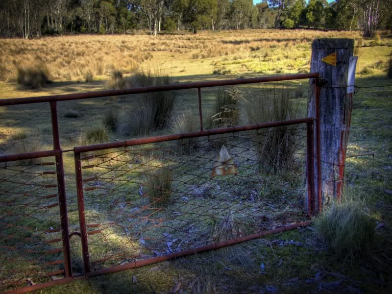
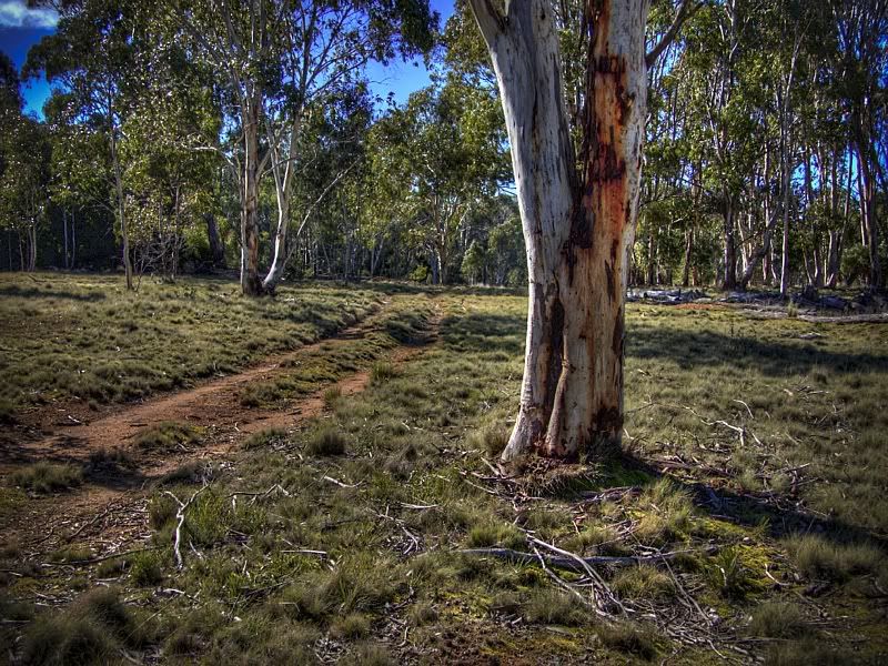
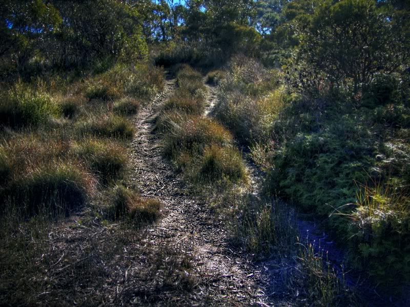
The Mount Werong BNT was the saving grace route, I wasn't far off losing the plot with the sign pollution at that stage in the National Park. Signs, signs everywhere a sign, playing with my head and fcuknig my mind (stolen from an old pleasing poem). The BNT was lots of grassy double tracks and wonderful to ride, I knew the track because I'd reccy'd it last year. Three shots from the reccy taken with my crappy little pocket camera.
The classic gate where the BNT leaves on the Oberon-Colong Stock Route (heading South) has such humble welcoming signs. The track towards Mount Werong then further-on to Mount Armstrong.
Warren.
PS, "I've been thinking of redoing one of the classic Blue Mts. MTB rides from Katoomba to Mittagong via Yerranderie." ... I like being in the Southern Blue Mountains.
Kanangra, I originally went to Yerranderie and I was going to ride along Scotts until I could dump the bike in the bush somewhere near Burn's Gap or further along Scotts and try to suss-out Axehead. I wanted shots of the Blue Breaks. The rule was no bikes beyond Yerranderie, most disappointing. The caretaker was helpful and gave me some good stealthy advice but the three Parks Rangers standing in front of the green building had me targeted. They were very friendly but gave me the impression that they are not always that friendly. Then when I'd packed up and I was saying goodbye to the caretaker (Mick?) and I told him I was going to do the BNT at Mount Werong, those rangers put the fear of God into me so I'm leaving, he said, "They weren't Park Rangers they were park day labourers, they were fixing a gate, a tree fell on it (or something similar). I thought that they were only hanging around to slap a ticket on my bike or on my forehead ... again, most disappointing.
" ... and the sheepwalk to the Wollondilly which we crossed before heading up the lake as the sun was setting. Finally exited via Picton."
After the failed Blue Breaks episode that was my intended route past the old mine and then up Sheehy's Creek Road. I was going to disassemble the bike, straighten the bars and remove the pedals and attach the frame to the webbing on the outside of my pack and walk with a wheel in each hand until I got out of the no-go bike zone and rebuild the bike. At that stage the signs had regressed to no-go People Zones. I had had the aggressive NSWP&W signage up to my dolly's wax.
The Mount Werong BNT was the saving grace route, I wasn't far off losing the plot with the sign pollution at that stage in the National Park. Signs, signs everywhere a sign, playing with my head and fcuknig my mind (stolen from an old pleasing poem). The BNT was lots of grassy double tracks and wonderful to ride, I knew the track because I'd reccy'd it last year. Three shots from the reccy taken with my crappy little pocket camera.
The classic gate where the BNT leaves on the Oberon-Colong Stock Route (heading South) has such humble welcoming signs. The track towards Mount Werong then further-on to Mount Armstrong.
Warren.
PS, "I've been thinking of redoing one of the classic Blue Mts. MTB rides from Katoomba to Mittagong via Yerranderie." ... I like being in the Southern Blue Mountains.
Last edited by WarrenH on Thu 03 Jun, 2010 7:29 pm, edited 1 time in total.
- WarrenH
- Phyllocladus aspleniifolius
- Posts: 991
- Joined: Thu 07 Jan, 2010 6:54 pm
- Region: Australian Capital Territory
Re: A Few Autumn Walks.
![]() by WarrenH » Thu 03 Jun, 2010 7:01 pm
by WarrenH » Thu 03 Jun, 2010 7:01 pm
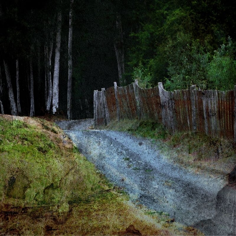
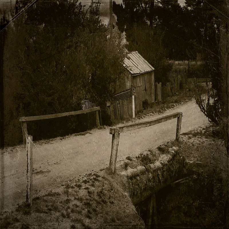
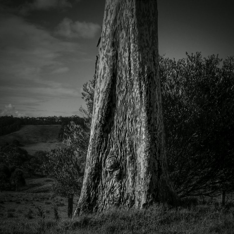
Autumn is over. It was a nice Autumn. Lots of rain. These are my three favourite shots from this Autumn past. The retro look suits.
I walked up an erosion gully off the Turon River and found a nice little town (again) surrounded by a dry forest of Box, Kurrajong and Inland Scribblies (and some Monterey Pines, planted by a Bernard Otto Holterman).
The Spotted Gum. Sunnyside Road, Mystery Bay, NSW South Coast. I photographed this giant tree on my way to climbing Gulaga. Gulaga is slippery.
Warren.
- WarrenH
- Phyllocladus aspleniifolius
- Posts: 991
- Joined: Thu 07 Jan, 2010 6:54 pm
- Region: Australian Capital Territory
Re: A Few Autumn Walks.
![]() by kanangra » Fri 04 Jun, 2010 1:25 pm
by kanangra » Fri 04 Jun, 2010 1:25 pm
Love your work. that B&W looks as if it was taken in the 1870's. Love the look of that track from Mt werong. will have to check that out.
K.
K.
- kanangra
- Athrotaxis selaginoides
- Posts: 1338
- Joined: Sun 25 May, 2008 3:52 pm
Re: A Few Autumn Walks.
![]() by iandsmith » Wed 20 Oct, 2010 8:35 pm
by iandsmith » Wed 20 Oct, 2010 8:35 pm
Some fascinating stuff there fellas. I'm a big fan of stepbystep's image - loved it! Some others, like the orchard tree lines and the fence line in that almost-sepia image were also wonderful. Found some of the others a little overworked in photoshop or similar which ruined them a little for me although WarrenH's first image is captivating.
Thanks for sharing fellas. I'll see if I can dig up a couple to add.
Mmm, okay, I know the Armidale shots aren't exactly what you guys normally expect but; I was walking and it was autumn.
Cheers all
Thanks for sharing fellas. I'll see if I can dig up a couple to add.
Mmm, okay, I know the Armidale shots aren't exactly what you guys normally expect but; I was walking and it was autumn.
Cheers all
- Attachments
-
- St. Mary's and St. Joseph's - Armidale
-
- St. Peters Cathedral - Armidale
-
- Superb Wren in eclipse plumage at Newnes. This bird got really close to the fire making it easy to take his picture
- Bird - male Superb Wren in eclipse plumage (4).jpg (91.45 KiB) Viewed 7840 times
-
- Lidsdale, where this pic was taken, is on the plateau just before you drop into the Wolgan River Valley
-
- This is a waterfall that seldom runs on the National Pass Trail and is indicative of how wet it has been this year
- np6.jpg (267.83 KiB) Viewed 7840 times
-
iandsmith - Athrotaxis cupressoides

- Posts: 366
- Joined: Thu 22 Jan, 2009 3:27 pm
- Location: Newcastle
Re: A Few Autumn Walks.
![]() by manda » Mon 27 Feb, 2012 3:10 pm
by manda » Mon 27 Feb, 2012 3:10 pm
Is it possible to get more information on the Pickering Creek Travelling stock route...?
Is it mentioned in "The Long Paddock"?
We live in on the Far South Coast of NSW and have walked in the area around Little Drom....but have never heard of this stock route...or any travelling stock routes in the area.....
Thanks..Manda
Is it mentioned in "The Long Paddock"?
We live in on the Far South Coast of NSW and have walked in the area around Little Drom....but have never heard of this stock route...or any travelling stock routes in the area.....
Thanks..Manda
- manda
- Nothofagus cunninghamii

- Posts: 2
- Joined: Mon 27 Feb, 2012 2:54 pm
- Region: New South Wales
- Gender: Female
Re: A Few Autumn Walks.
![]() by WarrenH » Tue 28 Feb, 2012 6:22 am
by WarrenH » Tue 28 Feb, 2012 6:22 am
manda wrote:Is it possible to get more information on the Pickering Creek Travelling stock route...?
Sorry, Pickering Creek is the wrong name, I meant to type Pittman's Creek which is a Travelling Stock Reserve not a Travelling Stock Route. On the South Coast no Travelling Stock Routes remain, thanks to the short sighted, cash strapped NSW State governments. The Long Paddock is a directory and atlas of the Travelling Stock Routes and Reserves and has basic information like, the size of the Reserve, what water is found on a Reserve, and is it from a dam, creek, river, lake, spring, mill, tank, trough or bore.
There are about 64 TSReserves still on the South Coast. The TS Reserves are the old drover's and shepherd's campsites and stock watering points. For the best info and access for the SE TSReserves contact the LHPA South East Region Rangers ... http://www.lhpa.org.au/districts/southeast It is wise not to enter a TSReserve before finding out if it is being leased to an adjoining property, or a stock permit has been issued. You will still be given permission to enter by a LHPA Ranger but not raise the ire of the farmer or wake up in the morning surrounded by 1,000 cows that were unloaded at night.
Just over the coastal ranges in the Monaro LHPA Region, there are 104 TS Reserves. There's no shortage of places to visit. I particularly like the TSRs because they are the original vegetation of Australia. Apiarists can apply for a Bee Keepers Permit to place their hives on a TSR because of the unique and relatively undisturbed plant communities.
The closest fair dinkum TSRoute to the South Coast is the historic Boorowa Track that starts (or terminates) at Coffee's Bridge over the Boorowa River on Rugby Road, 8 kilometres NE of the town of Boorowa. Boorowa is North of Yass, a fair distance from the coast. The Boorowa Travelling Stock Route eventually joins the Monteagle TSRoute, which can be followed into Queensland along several possible interconnected TSRoutes, eventually reaching the Gulf of Carpentaria.
The next closest routes to the South Coast are relatively short (only 30-40 kilometres long). East of Tumut, East of Tumbarumba and East of Wagga Wagga. In western NSW many of the big routes still remain and can be followed into Queensland. The Stock Route Network in Queensland is still in its entirety, 73,000 kilometres of routes. In Victoria they don't have a TSR&R network. Graziers apply for road-side grazing permits or they let the cows loose in National Parks.
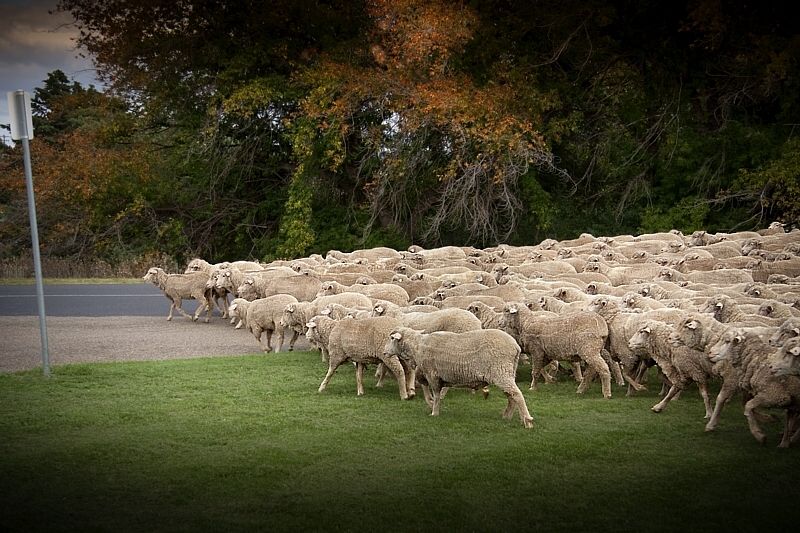
This is an Autumn shot from last Autumn when I was on the BNT and called into Adaminaby ... the sheep walk.
Warren.
- WarrenH
- Phyllocladus aspleniifolius
- Posts: 991
- Joined: Thu 07 Jan, 2010 6:54 pm
- Region: Australian Capital Territory
Re: A Few Autumn Walks.
![]() by manda » Tue 28 Feb, 2012 1:44 pm
by manda » Tue 28 Feb, 2012 1:44 pm
Thanks for all that Info. Warren....
We shall certainly do some more research before heading out along or into any stock reserves.....
We usually stick to the forestry tracks...but seeing your picture of Little Drom. took our notice as we have been able to explore it several times(with permission of owners)...it is a magical place.
Thanks for sharing your photos...they are inspiring.
Manda
- manda
- Nothofagus cunninghamii
- Posts: 2
- Joined: Mon 27 Feb, 2012 2:54 pm
- Region: New South Wales
- Gender: Female
40 posts
• Page 2 of 2 • 1, 2
Who is online
Users browsing this forum: No registered users and 25 guests