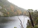
Watersmeet

Cool fungi

Cool fungi (crop)

A stream on the side of the track towards Shadow Lake

Sticking out from nowhere - looked pretty cool.

Coral fern and snow

Interesting bark

Stripped

Mossy stuff

Sunrise at Shadow Lake, towards Rufus

Sunrise at Shadow Lake, towards Little Hugel

Sunrise at Shadow Lake, towards Little Hugel

Sunrise at Shadow Lake, towards Hugel

Sunrise at Shadow Lake, towards Rufus and Hugel

Sunrise at Shadow Lake, towards Hugel

Sunrise at Shadow Lake - Little Hugel

Sunrise at Shadow Lake, towards Hugel

A HDR image comprising several photos including the one above, enhancing the frost on the other side of the lake.

Sunrise at Shadow Lake, towards Hugel

Frost on the side of the track

Tarns on the plateau between Little Hugel and Hugel

Tarns on the plateau between Little Hugel and Hugel

Tarns on the plateau between Little Hugel and Hugel

Tarns on the plateau between Little Hugel and Hugel

Tarns on the plateau between Little Hugel and Hugel

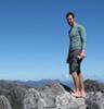
Summit of Hugel

Mt Rufus from Mt Hugel

Looking down on the upper reaches of the catchment for the Franklin River.

Looking down on the upper reaches of the catchment for the Franklin River.

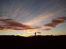
Sunset at Shadow Lake

Sunset at Shadow Lake

Sunset at Shadow Lake

Sunset at Shadow Lake

Hope you enjoyed