Unfortunately, we ran into some trouble early... Here's a tip, if you too want to do this walk from the Collinsvale side; take the Myrtle Forest Track, not the Myrtle Forest Trail...
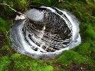
It was about an hour along the trail before we decided that the track notes had said we were definitely supposed to be walking next to a creek, and not in it. Safe to say that we probably should have paid a little more attention, but oh well, at least it took us to this lovely little creek:

So after heading back to the picnic area, having a bit of a break and de-leeching (4 total, including the one that was trying his hardest to get into my mouth...), we headed up the track.
Within 5 or so minutes, one's greeted by this lovely little set of falls:

So if you don't see them within the first little while, turn around, because you've probably gone the wrong way!
A steady uphill climb for an hour or so, zig-zagging across the face of the hill with lovely views of collins cap through the trees eventually brought us onto the east-west firetrail. We quickly found the hut and decided to have a snack (and attempt to dry my shoes from the aforementioned creek walk!). Pretty sure we were having the most colourful scroggin ever consumed in the Tassie bush...


After that, it was a short walk along the firetrail to find the start of the ascent to CB, though reading the abels book again, it sounds as though there's a track which leaves directly from the hut.
The climb up CB was fairly pleasant, and quite well marked, with a few small boulder fields like this one to contend with

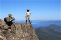
The summit/climb also gave great views back towards Mt Wellington

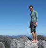
We reached the top of CB at somewhere around 1345, and given our 2hr sidetrip earlier, had to reconsider our goals for the day. Immediately after we discovered our wrong turn, we though we'd only be able to do CB, but Trestle Mtn looked so inviting from the top of CB that we just couldn't resist, so off we headed back down the fire trail!
This one shows Trestle to the left, and Mt Marian to the right

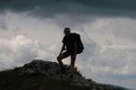
It probably took us 1 1/2 hours or so to make it from CB to the summit of TM, mostly along the E-W fire trail, but again, the views were worth it


So after summiting TM, it was back down to the fire trail, taking a left onto the Collins Cap track, which we eventually used to rejoin the Myrtle Forest Track, and headed back down to the car in the dark at about 1730! All in all, 9 hours of our time well spent, even if it was frustrating knowing that we probably could have done Mt Marian too. I guess that's just an excuse to come back and do it from the big bend next time instead!
Anyway, my apologies for the photo dump, but I find things are much more interesting when you can see what someone's talking about!
I'll leave you with one last photo, which was originally actually taken as two separate panoramas, but whilst I was editing them, I saw that they would probably fit together as one! Here's the result:

(If you want to see this, or any of the others larger, feel free to have a look at my Flickr, the link for which you will find in my signature!)
Thanks for looking guys and girls.