Hi there, Just wondering if anyone had any more info about walking to mt cougal from the Tallebudgera Valley - is there any obvious track to follow? & where you start from? Or if anyone has any other info on walks in the Talley Valley? Really enjoyed reading all these posts & checking out the pics. Magic part of the world.
Cheers,
Jane.
Mt Cougal/Springbrook
Forum rules
Queensland specific bushwalking discussion. Please avoid publishing details of access to sensitive areas with no tracks.
Queensland specific bushwalking discussion. Please avoid publishing details of access to sensitive areas with no tracks.
139 posts
• Page 2 of 5 • 1, 2, 3, 4, 5
Re: Mt Cougal/Springbrook
![]() by footstomp » Wed 28 Dec, 2011 8:23 pm
by footstomp » Wed 28 Dec, 2011 8:23 pm
- footstomp
- Nothofagus cunninghamii

- Posts: 1
- Joined: Wed 28 Dec, 2011 8:16 pm
- Region: Queensland
- Gender: Female
Re: Mt Cougal/Springbrook
![]() by tomh » Fri 30 Dec, 2011 3:11 pm
by tomh » Fri 30 Dec, 2011 3:11 pm
No obvious track from Tallebudgera valley to the Cougals Jane - in fact the only obvious track to the Cougals is from the end of the Garden of Eden Road (off Tomewin Road) following the border fence to East Cougal then a little less obvious to West Cougal.
- tomh
- Athrotaxis cupressoides

- Posts: 158
- Joined: Wed 02 Jun, 2010 3:44 pm
- Region: Queensland
- Gender: Male
Re: Mt Cougal/Springbrook
![]() by firstTimeCaller » Mon 06 Feb, 2012 2:40 pm
by firstTimeCaller » Mon 06 Feb, 2012 2:40 pm
I've not done the full track but if you are interested I put our walk from Garden of Eden Rd to Mt Cougal East here....
http://en.wikiloc.com/wikiloc/view.do?id=1187641
If/when we manage to do the full track I'll do another post.
Cheers
http://en.wikiloc.com/wikiloc/view.do?id=1187641
If/when we manage to do the full track I'll do another post.
Cheers
- firstTimeCaller
- Nothofagus gunnii

- Posts: 10
- Joined: Sun 05 Feb, 2012 2:39 pm
- Region: Queensland
- Gender: Male
Re: Mt Cougal/Springbrook
![]() by tas-man » Mon 06 Feb, 2012 10:11 pm
by tas-man » Mon 06 Feb, 2012 10:11 pm
While looking through my map cabinet, I found a photocopy of the article I mentioned earlier in this topic written by Harley Smith in the mid 1970's for the UQBWC annual magazine "Heybob." Much may have changed in respect to the access routes to the various features, but there may be sufficient information to whet the appetite for some exploration of the region.
"The world reveals itself to those who travel on foot."
Werner Herzog
Werner Herzog
-

tas-man - Athrotaxis selaginoides

- Posts: 1479
- Joined: Mon 03 Sep, 2007 8:55 pm
- Location: Riverside
- Region: Tasmania
- Gender: Male
Re: Mt Cougal/Springbrook
![]() by tas-man » Mon 06 Feb, 2012 10:28 pm
by tas-man » Mon 06 Feb, 2012 10:28 pm
"The world reveals itself to those who travel on foot."
Werner Herzog
Werner Herzog
-
tas-man - Athrotaxis selaginoides
- Posts: 1479
- Joined: Mon 03 Sep, 2007 8:55 pm
- Location: Riverside
- Region: Tasmania
- Gender: Male
Re: Mt Cougal/Springbrook
![]() by tas-man » Mon 06 Feb, 2012 10:37 pm
by tas-man » Mon 06 Feb, 2012 10:37 pm
"The world reveals itself to those who travel on foot."
Werner Herzog
Werner Herzog
-
tas-man - Athrotaxis selaginoides
- Posts: 1479
- Joined: Mon 03 Sep, 2007 8:55 pm
- Location: Riverside
- Region: Tasmania
- Gender: Male
- firstTimeCaller
- Nothofagus gunnii
- Posts: 10
- Joined: Sun 05 Feb, 2012 2:39 pm
- Region: Queensland
- Gender: Male
Re: Mt Cougal/Springbrook
![]() by firstTimeCaller » Mon 09 Jul, 2012 12:36 pm
by firstTimeCaller » Mon 09 Jul, 2012 12:36 pm
We had an attempt of doing the "Cream Track" from the end of Tallebugera Creek Rd to Springbrook on the weekend. We were put off by the big "Private Property" signs at the gate at end of the road. So instead of going over the gate, we headed from the carpark @ (-28.217106,153.321997) approx 100m back down the road where we could cross the creek and headed up a ridge that ran approx WNW. It as a bit overgrown and steep but seemed to be some sort of an old track there. It was a nice walk but we didn't have a lot of time and turned around @ (-28.213671,153.316029). It looked as through you could continue up the track. I had a GPS app running on my phone so was able to look at our track on returning home.
It's probably worth noting that the end of road and gate is @ (-28.217106,153.321997), while google maps has the road running another approx 1km up the valley.
I think the correct way to do the cream track is to head over the "private property" gate at the end of the road.
Can anyone confirm this? Were you shot at?
- firstTimeCaller
- Nothofagus gunnii
- Posts: 10
- Joined: Sun 05 Feb, 2012 2:39 pm
- Region: Queensland
- Gender: Male
Re: Mt Cougal/Springbrook
![]() by Haribolman » Tue 10 Jul, 2012 7:07 pm
by Haribolman » Tue 10 Jul, 2012 7:07 pm
I've just joined this forum in order to comment on this thread, so this is my first post. Having lived in Currumbin Valley for more than 25 years, I'm fairly familiar with the area. I was researching a walk I took a few years ago when I came across this thread. It's in the Mt Cougall area, but it's not accessed from the Garden of Eden Rd.
About 12 years ago or so, I took a very early morning summer drive to the end of Currumbin Valley, just past Camp Eden and decided to walk along the tourist track in the Mt Cougall section of the Springbrook National Park towards the abandoned timber mill. However, I noticed a track that came off the left of the main walking track and went steeply uphill. I decided to explore and was amazed to discover a phone line very crudely strung through the trees along the track. This got my curiousity and I continued walking uphill, following the phone line through the bush. After some time I was getting quite high up the hill. Imagine my surprise to discover an abandoned house, sitting in the bush, with seemingly no means of getting to it other than this very steep track up a hill. I walked quietly around the outside of the house, only to discover another couple of houses further in the distance on the top edge of this hill.
I discovered years later that the houses were built by squatters, and discovered by a drug spotter plane flying over the valley. Aparently they are on land owned by Canp Eden and the phone line was to communicate between them and the Camp. The houses had no electricity or running water, but were offered to Camp Eden teachers for very little rent. A friend who has stayed at Camp Eden in more recent years tells me that the first walk she was taken on was to the abandoned houses!
It's possible to see what looks like them on Google maps, but even easier to see them on Nearmap. It does look like you could access them from the Garden of Eden road too!
- Haribolman
- Nothofagus gunnii
- Posts: 13
- Joined: Wed 20 Jun, 2012 8:42 pm
- Region: Queensland
- Gender: Male
Re: Mt Cougal/Springbrook
![]() by Haribolman » Tue 10 Jul, 2012 7:25 pm
by Haribolman » Tue 10 Jul, 2012 7:25 pm
firstTimeCaller wrote:We had an attempt of doing the "Cream Track" from the end of Tallebugera Creek Rd to Springbrook on the weekend. It was a nice walk but we didn't have a lot of time and turned around @ (-28.213671,153.316029). It looked as through you could continue up the track.
I think the correct way to do the cream track is to head over the "private property" gate at the end of the road.
Can anyone confirm this? Were you shot at?
According to this website https://sites.google.com/site/halwalks/ ... pringbrook you were in the right area, but needed to be slightly further south. If you look on Nearmap, you'll clearly see the banana plantation referred to, and you need to be to the south of it to find the ridge to Springbrook.
- Haribolman
- Nothofagus gunnii
- Posts: 13
- Joined: Wed 20 Jun, 2012 8:42 pm
- Region: Queensland
- Gender: Male
Re: Mt Cougal/Springbrook
![]() by firstTimeCaller » Wed 11 Jul, 2012 8:56 am
by firstTimeCaller » Wed 11 Jul, 2012 8:56 am
Thanks. Wow...nearmap resolution is great. You can see the individual banana trees in the banana plantation. I agree with your "further south" assessment. We will have to have another crack at it heading over the gate.
I think the "Private Property" signs might be slightly misleading. I had a look at the property boundaries on http://gis.qld.gov.au/iqed/map/ and there is definitely a easement/right-of-way/road reserve heading up to Springbrook so I feel a bit more comfortable about jumping the gate. Nearmap actually has Springbrook Rd connecting to Tallebugera Rd over the course of what I suppose is the Cream track. Slightly misleading for motorists but handy for walkers.
Also of note, there is a mention of the Cream Track in this document - http://www.goldcoast.qld.gov.au/attachm ... stions.pdf which describes possible new tracks to be opened up for bushwalking.
- firstTimeCaller
- Nothofagus gunnii
- Posts: 10
- Joined: Sun 05 Feb, 2012 2:39 pm
- Region: Queensland
- Gender: Male
Re: Mt Cougal/Springbrook
![]() by Haribolman » Thu 12 Jul, 2012 6:41 pm
by Haribolman » Thu 12 Jul, 2012 6:41 pm
firstTimeCaller wrote:Thanks. Wow...nearmap resolution is great. You can see the individual banana trees in the banana plantation. I agree with your "further south" assessment. We will have to have another crack at it heading over the gate.
I think the "Private Property" signs might be slightly misleading. I had a look at the property boundaries on http://gis.qld.gov.au/iqed/map/ and there is definitely a easement/right-of-way/road reserve heading up to Springbrook so I feel a bit more comfortable about jumping the gate. Nearmap actually has Springbrook Rd connecting to Tallebugera Rd over the course of what I suppose is the Cream track. Slightly misleading for motorists but handy for walkers.
Also of note, there is a mention of the Cream Track in this document - http://www.goldcoast.qld.gov.au/attachm ... stions.pdf which describes possible new tracks to be opened up for bushwalking.
Yes, Nearmap can sometimes blow Google maps away for resolution...pity it has no streetview!
The pdf you referenced is interesting because it is ten years old it still lists the walk to Bilbrough lookout at Springbrook as useable. That track has been closed for a few years now at least. I walked it once and would love to do it again, but am not sure if I should try!
As for the Cream Track, I'm not much for ignoring Private Proerty signs (in some parts of Australia, ignore them at your risk!).
For those attempting to access Mt Cougall (other than the Border fence) it's interesting that there is a Mt Cougall Rd coming off Tallebudgera Creek Rd, which heads in the general direction of Mt Cougall, but ends up being private property. Nearmap also clearly shows the track that continues from the end of Ryan's Rd to the top of a nearby mountain. (This track is very hard to see on Google maps).
And finally, considering how many times I see a map showing a road continuing where there is none, I find it interesting that Nearmap correctly shows Dalton Rd stopping where it does. This is significant because when the Dalton Rd estate was opened many years ago, it was planned to continue much further up and around the mountain to the left (I clearly remember the map outside the sales office) but was abandoned due to land slides. To this day the road upruptley stops whilst going uphill with an armco barrier across it, rather than a planned cul-de-sac! This is the one time a map should have shown the original road's intended path and didn't! Arrgghh!!!
- Haribolman
- Nothofagus gunnii
- Posts: 13
- Joined: Wed 20 Jun, 2012 8:42 pm
- Region: Queensland
- Gender: Male
Re: Mt Cougal/Springbrook
![]() by Haribolman » Fri 20 Jul, 2012 8:57 pm
by Haribolman » Fri 20 Jul, 2012 8:57 pm
Haribolman wrote:About 12 years ago or so, I took a very early morning summer drive to the end of Currumbin Valley, just past Camp Eden and decided to walk along the tourist track in the Mt Cougall section of the Springbrook National Park towards the abandoned timber mill. However, I noticed a track that came off the left of the main walking track and went steeply uphill. I decided to explore and was amazed to discover a phone line very crudely strung through the trees along the track. This got my curiousity and I continued walking uphill, following the phone line through the bush. After some time I was getting quite high up the hill. Imagine my surprise to discover an abandoned house, sitting in the bush, with seemingly no means of getting to it other than this very steep track up a hill. I walked quietly around the outside of the house, only to discover another couple of houses further in the distance on the top edge of this hill.
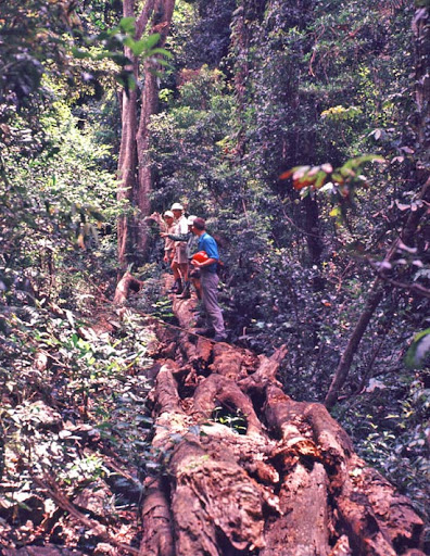
Well, we decided to walk up the Mt Cougall track today to see how accurate my memory of the old abandoned houses were. I also took a camera this time and recorded the walk on my GPS so I could see where we got to!
The track is as steep as I remember, but much more overgrown than it was last time I walked it. The phone line is still strung through the trees as you get higher up the hill. But it has been downed and broken by falling branches in one section. There's an old fenced enclosure (sort of like a horse corral) beside the track which is harder to see now that all the bush has grown around it. What I remember as the first old house you pass has now been reduced to a crumbling mess of iron wall and roof sheets, almost hidden by the surrounding bush. It no longer resembles a house, rather an abandoned shed. Nearby is a small dam, an old motorbike in the bush and several old water tanks and an old rock wall. I could no longer see the other houses in the distance (as I could many years ago), but I walked further this time and reached a dirt road that the map seems to show as being very close to the Garden of Eden Road, which runs along the border.
So it seems we almost walked to the border, reaching a height of 400 metres. We were high enough to get good photos of Mt Cougall through the trees. It's impossible to see the shed on Nearmap due to the tree coverings.
- Haribolman
- Nothofagus gunnii
- Posts: 13
- Joined: Wed 20 Jun, 2012 8:42 pm
- Region: Queensland
- Gender: Male
Re: Mt Cougal/Springbrook
![]() by tas-man » Sat 21 Jul, 2012 10:06 am
by tas-man » Sat 21 Jul, 2012 10:06 am
Haribolman wrote:<snip>We were high enough to get good photos of Mt Cougall through the trees.
Looking forward to seeing some of your photos of Mt Cougal and this area
"The world reveals itself to those who travel on foot."
Werner Herzog
Werner Herzog
-
tas-man - Athrotaxis selaginoides
- Posts: 1479
- Joined: Mon 03 Sep, 2007 8:55 pm
- Location: Riverside
- Region: Tasmania
- Gender: Male
Re: Mt Cougal/Springbrook
![]() by tas-man » Sat 21 Jul, 2012 10:38 am
by tas-man » Sat 21 Jul, 2012 10:38 am
I just did a search for "Harley Smith" to see if there were any references to Harley who wrote the Heybob article posted earlier in this thread, and was interested to find that there is a park on the corner of Tallebudgera Creek Road and Araluen Road named "Harley Smith Reserve." Do any of you in the region know the background story to this park? I assume it must have been donated to the council by the Smith family at some time.
"The world reveals itself to those who travel on foot."
Werner Herzog
Werner Herzog
-
tas-man - Athrotaxis selaginoides
- Posts: 1479
- Joined: Mon 03 Sep, 2007 8:55 pm
- Location: Riverside
- Region: Tasmania
- Gender: Male
Re: Mt Cougal/Springbrook
![]() by Haribolman » Sun 22 Jul, 2012 9:13 pm
by Haribolman » Sun 22 Jul, 2012 9:13 pm
tas-man wrote:Looking forward to seeing some of your photos of Mt Cougal and this area
- Mt Cougall through the trees
- Fallen tree
- Steep uphill walk!
- Phone lines through trees
- The end of the line!
- Haribolman
- Nothofagus gunnii
- Posts: 13
- Joined: Wed 20 Jun, 2012 8:42 pm
- Region: Queensland
- Gender: Male
Re: Mt Cougal/Springbrook
![]() by Haribolman » Sun 22 Jul, 2012 9:31 pm
by Haribolman » Sun 22 Jul, 2012 9:31 pm
- Hidden "horse corral" fence
- The crumbling shed that once resembled a building!
- Rock wall in the bush!
- The road I walked to. This is close to the Garden of Eden Road.
- The old building has almost totally collapsed.
I think the strangest thing is that I'd remembered the old building as looking like a liveable house. But upon seeing it again, it simply looks like a derelict shed. I can't imagine it ever looking like a house. Memory, eh? All other things were correct in my memory, the phone line through the trees, the horse corral fence to the left of the track, the small dam to the right. And I rememer the track meandering closely past the side of the building, but why did the building look like a house in my memory?
Also, because of the growth of the bush, it's no longer possible to see the other two houses across the edge of the ridge. However, if I'd walked up the dirt road I would have come upon them. But by this stage I decided I was most likely on someone's property and they may not appreciate it!
- Haribolman
- Nothofagus gunnii
- Posts: 13
- Joined: Wed 20 Jun, 2012 8:42 pm
- Region: Queensland
- Gender: Male
Re: Mt Cougal/Springbrook
![]() by tas-man » Mon 23 Jul, 2012 1:32 pm
by tas-man » Mon 23 Jul, 2012 1:32 pm
firstTimeCaller wrote:We had an attempt of doing the "Cream Track" from the end of Tallebugera Creek Rd to Springbrook on the weekend. We were put off by the big "Private Property" signs at the gate at end of the road. So instead of going over the gate, we headed from the carpark @ (-28.217106,153.321997) approx 100m back down the road where we could cross the creek and headed up a ridge that ran approx WNW. It as a bit overgrown and steep but seemed to be some sort of an old track there. It was a nice walk but we didn't have a lot of time and turned around @ (-28.213671,153.316029). It looked as through you could continue up the track. I had a GPS app running on my phone so was able to look at our track on returning home.
It's probably worth noting that the end of road and gate is @ (-28.217106,153.321997), while google maps has the road running another approx 1km up the valley. I think the correct way to do the cream track is to head over the "private property" gate at the end of the road.
Can anyone confirm this? Were you shot at?
I found my old 1971 Springbrook National Park map that I had used on my walk up the Cream Track in November 1974, and have scanned the section showing the route I followed marked in blue biro. The track mostly follows a gazetted road reserve that existed when this map was published, but this would need to be checked on current titles records and maps before assuming that public access is still permitted. I have some slides of the walk that might be of interest, so will keep looking for them.
"The world reveals itself to those who travel on foot."
Werner Herzog
Werner Herzog
-
tas-man - Athrotaxis selaginoides
- Posts: 1479
- Joined: Mon 03 Sep, 2007 8:55 pm
- Location: Riverside
- Region: Tasmania
- Gender: Male
Re: Mt Cougal/Springbrook
![]() by firstTimeCaller » Mon 23 Jul, 2012 2:34 pm
by firstTimeCaller » Mon 23 Jul, 2012 2:34 pm
That's a beautiful old map.
Here's the property boundaries that I've pulled of the government website. It looks like the road reserve follows roughly the same course as you've marked on your track.
Here's the property boundaries that I've pulled of the government website. It looks like the road reserve follows roughly the same course as you've marked on your track.
- Attachments
-
- firstTimeCaller
- Nothofagus gunnii
- Posts: 10
- Joined: Sun 05 Feb, 2012 2:39 pm
- Region: Queensland
- Gender: Male
Re: Mt Cougal/Springbrook
![]() by Haribolman » Tue 24 Jul, 2012 3:25 pm
by Haribolman » Tue 24 Jul, 2012 3:25 pm
tas-man wrote:I just did a search for "Harley Smith" to see if there were any references to Harley who wrote the Heybob article posted earlier in this thread, and was interested to find that there is a park on the corner of Tallebudgera Creek Road and Araluen Road named "Harley Smith Reserve." Do any of you in the region know the background story to this park?
Unless I'm mistaken, the reserve in the photo was an area used for camping back in the 80's. Beyond the carpark the road runs over a small bridge and continues winding up a steep hill for quite some time. It used to have a gate where the bridge is. And a name on the gate, similar to "Biassians", whom I believe owned the property at the time.
Talking about stories of the region, nearby is a street called Petsch's Creek Rd. Back in the early 80's my friend and I were there one day photographing our cars. We parked them just off the street in front of an old abandoned farm house. Whilst taking photos an old man road up the street on a bicycle and questioned why we were there. He seemed extremely paranoid, accusing us of being there to case the place for drugs. He ranted and raved about the governement and it was clear he didn't have all his marbles. We told him we'd leave and he rode off.
But before we could pack up a younger man driving a truck stopped and he also questioned us suspiciously about why we were there. He told us we shouldn't be there and we decided that it was best we leave straight away. He drove off and my mate and I just shook our heads in amazement at the crazies living in that street.
This would be the end of the story if it wasn't for a conversation I had with the local postie of that area a number of year later. I told him that some of the people in that street were nutters and he told me the following. Apparently the two people we met were father and son and they owned a very large portion of the land in Petsch's Creek Rd. One of them went mad and shot the other and then I think he killed himself. I just don't recall if it was father shot son (more likely) or son shot father. After the deaths the land was sold and subdivided and contains many acreage lots today.
Interestingly, the old farmhouse remains!! It's still sitting there, at the front of someone's block, just off the side of the road, surrounded by mature bushy trees. Why it was never torn down I don't understand.
- Haribolman
- Nothofagus gunnii
- Posts: 13
- Joined: Wed 20 Jun, 2012 8:42 pm
- Region: Queensland
- Gender: Male
Re: Mt Cougal/Springbrook
![]() by tas-man » Tue 24 Jul, 2012 4:07 pm
by tas-man » Tue 24 Jul, 2012 4:07 pm
Thanks Haribolman for your photos - I can smell the rainforest!
Firstimecaller, I plotted your GPS co-ords in Google Earth and you were following a road reserve that probably was developed years ago as access to banana plantations on the eastern face of these ridges. I remember discussions with Harley Smith about the history of this area, and the valley was subdivided into farm lots after the Second World War for Soldier Settlers to clear and work, but most failed to make a go of it, and farms were consolidated as time passed. I have marked up the Cream Track route and your route on a Google Maps aerial view to show the difference. I am still looking for my old slides as I remember taking a photos of the well preserved trackwork in the rainforest just below the Springbrook plateau is reached, and the track cutting through the final ridge top that was an impressive bit of pick and shovel work.
Firstimecaller, I plotted your GPS co-ords in Google Earth and you were following a road reserve that probably was developed years ago as access to banana plantations on the eastern face of these ridges. I remember discussions with Harley Smith about the history of this area, and the valley was subdivided into farm lots after the Second World War for Soldier Settlers to clear and work, but most failed to make a go of it, and farms were consolidated as time passed. I have marked up the Cream Track route and your route on a Google Maps aerial view to show the difference. I am still looking for my old slides as I remember taking a photos of the well preserved trackwork in the rainforest just below the Springbrook plateau is reached, and the track cutting through the final ridge top that was an impressive bit of pick and shovel work.
"The world reveals itself to those who travel on foot."
Werner Herzog
Werner Herzog
-
tas-man - Athrotaxis selaginoides
- Posts: 1479
- Joined: Mon 03 Sep, 2007 8:55 pm
- Location: Riverside
- Region: Tasmania
- Gender: Male
Re: Mt Cougal/Springbrook
![]() by tas-man » Thu 09 Aug, 2012 9:56 am
by tas-man » Thu 09 Aug, 2012 9:56 am
I have found some of the old slides from my trip up the Cream Track in November 1974 and will post a few for your amusement. The location of the old house on top of Springbrook is still identifiable on Google Earth but the open pasture in my photos has now been largely covered by regrowth.
- Our campsite on Tallebudgera Creek on the Smith's property. Their farmhouse "Beechwoods" is in the background, but today no longer visible from the road due to vegetation growth.
- This was the last causeway crossing on Tallebudgera Creek Road. The parking area today at the end of the road before the Private Property sign is just a bit further to the right. The tree on the left is still there, and the power poles, but the house on the left doesn't seem to match with the ones now there in Google Maps.
- Rock hopping up Tallebudgera Creek - like the vintage walking gear!
"The world reveals itself to those who travel on foot."
Werner Herzog
Werner Herzog
-
tas-man - Athrotaxis selaginoides
- Posts: 1479
- Joined: Mon 03 Sep, 2007 8:55 pm
- Location: Riverside
- Region: Tasmania
- Gender: Male
Re: Mt Cougal/Springbrook
![]() by tas-man » Thu 09 Aug, 2012 10:07 am
by tas-man » Thu 09 Aug, 2012 10:07 am
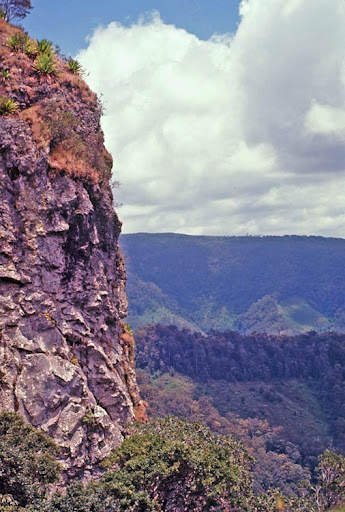
Here are a few more photos from the top of Springbrook.
- View from old farmhouse on top of Springbrook.
- The old farmhouse on top of Springbrook.
- Looking South East to Boyd's Butte and East Peak of Mt Cougal from old farmhouse.
"The world reveals itself to those who travel on foot."
Werner Herzog
Werner Herzog
-
tas-man - Athrotaxis selaginoides
- Posts: 1479
- Joined: Mon 03 Sep, 2007 8:55 pm
- Location: Riverside
- Region: Tasmania
- Gender: Male
Re: Mt Cougal/Springbrook
![]() by firstTimeCaller » Thu 09 Aug, 2012 11:21 am
by firstTimeCaller » Thu 09 Aug, 2012 11:21 am
Nice gear! We had another attempt 2 weeks ago and made it about 3/4 of the way up - about half way between the top of the bananas and the ridge line. Will be attempting the full distance ASAP. Once we make it the whole way, I'll post some pics and GPS logs.
- firstTimeCaller
- Nothofagus gunnii
- Posts: 10
- Joined: Sun 05 Feb, 2012 2:39 pm
- Region: Queensland
- Gender: Male
Re: Mt Cougal/Springbrook
![]() by gentlemanbushwalker » Wed 15 Aug, 2012 10:34 pm
by gentlemanbushwalker » Wed 15 Aug, 2012 10:34 pm
Hi all,
Have been watching this thread for quite some time and decided to register because of it.
Really enjoyed seeing some of the old material and tas-mans great photos of the area!
Cougal is a fantastic place and I have been up east peak a few times now. Have been across the ridge and halfway up the west peak but refused to go any further without ropes and a stronger sense of balance...
Have also been to Boyd's Butte - 2 out of the 3 'peaks', the furthest north looks fairly technical. Anyone who has been there recently might share my view that it seems to be eroding somewhat - there were some very large, unstable rocks on our last walk in 2011.
I am looking forward to finding out more about the cream track. Have wandered around a little across the river from the car park where the road gets closed off but couldn't find anything.
The idea of having a track from Garden of Eden road to Springbrook Plateau is very exciting. When I was on the west peak there was a track going down the mountain to the west, pretty well defined as I remember, though I haven't the faintest where it goes. Google maps shows a road going from currrumbin creek road, north of Boyd's, through to tallebudgerra valley, but this is a not accurate as the road of sorts stops halfway through from the currumbin side. Great way to access the ridge and Boyd's however, and sure as hell quicker than walking up from the sawmill!
The old fire track with the telephone that heads up from the sawmill area does end on private property so far as I know. Taking a left at the end of that track will put you at the gate you have to jump to start the main Cougal walk. From what I can gather the owners have been quite accommodating for bushwalkers, as I think the start of the Cougal track is actually their property before it turns into National Park and they have been nice enough to put signs up.
- gentlemanbushwalker
- Nothofagus cunninghamii
- Posts: 8
- Joined: Wed 15 Aug, 2012 9:57 pm
- Region: Queensland
Re: Mt Cougal/Springbrook
![]() by Haribolman » Fri 17 Aug, 2012 8:58 pm
by Haribolman » Fri 17 Aug, 2012 8:58 pm
gentlemanbushwalker wrote:The old fire track with the telephone that heads up from the sawmill area does end on private property so far as I know. Taking a left at the end of that track will put you at the gate you have to jump to start the main Cougal walk. From what I can gather the owners have been quite accommodating for bushwalkers, as I think the start of the Cougal track is actually their property before it turns into National Park and they have been nice enough to put signs up.
Greetings...good to read from someone who knows the area well.
It seems my deductions were correct. The dirt road I walked to (shown in one of the photos) seemed to lead back to the gate where the Garden of Eden Rd is. I didn't realise the track was an old fire track, but halfway up the track there's a long disused gate swung permanently open at about the spot on the map where the National Park becomes private property. The beginning of the track is not actually at the sawmill, but down at the edge of the carpark itself.
And there's a track leading off to Camp Eden a little while up the fire track, but I have not yet walked it.
Seeing as you know the area, had you heard the story about the squatters shacks built there many years ago?
- Haribolman
- Nothofagus gunnii
- Posts: 13
- Joined: Wed 20 Jun, 2012 8:42 pm
- Region: Queensland
- Gender: Male
Re: Mt Cougal/Springbrook
![]() by gentlemanbushwalker » Sat 18 Aug, 2012 1:00 am
by gentlemanbushwalker » Sat 18 Aug, 2012 1:00 am
Have been along the camp eden tracks once by mistake and once by necessity (doing a round trip and had to get down to the creek at camp eden - Ran out of water and dehydrated, rookie mistake!). Didn't know the story until I read your post so good to find out some local history thanks Haribolman. The track where the gate is will also lead you via camp eden flying fox up to garden of eden road, seems that they own the property however. Last time I was on the fire trail (mid-2011) there was a classic old Honda Moped rusting away and a dam full of water aswell. The shack in you picture was just still standing so must have only recently fallen over.
- gentlemanbushwalker
- Nothofagus cunninghamii
- Posts: 8
- Joined: Wed 15 Aug, 2012 9:57 pm
- Region: Queensland
Re: Mt Cougal/Springbrook
![]() by tecais » Sat 18 Aug, 2012 2:28 am
by tecais » Sat 18 Aug, 2012 2:28 am
I too have been following this thread with some interest. Tasman's thorough documentation and pictures are a fascinating glimpse back in time.
Some may be interested to know Bert Salmon climbed the Cougal Twins on August 12, 1931 with Jean Easton, Nora Dimes, Eddie ?, Eric ? and Harry Payne.
Not to hijack the thread, but much later in 1964 we climbed all three pinnacles of Boyd's Butte but never made it to the Cougals. Even then the Butte was a crumbling pile of loose blocks embedded in a dirt matrix so perhaps little has changed.
We didn't use ropes and found the north pinnacle to be the most perilous, involving a scrabble up vertical dirt on the south arete.
Don't remember much about our approach route except we came up the north ridge then descended the west flank to the creek. The descent was was some of the worst bush bashing I have ever done through dense lantana.
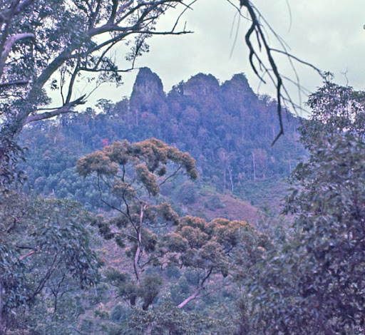
Some representative pictures:

Some may be interested to know Bert Salmon climbed the Cougal Twins on August 12, 1931 with Jean Easton, Nora Dimes, Eddie ?, Eric ? and Harry Payne.
Not to hijack the thread, but much later in 1964 we climbed all three pinnacles of Boyd's Butte but never made it to the Cougals. Even then the Butte was a crumbling pile of loose blocks embedded in a dirt matrix so perhaps little has changed.
We didn't use ropes and found the north pinnacle to be the most perilous, involving a scrabble up vertical dirt on the south arete.
Don't remember much about our approach route except we came up the north ridge then descended the west flank to the creek. The descent was was some of the worst bush bashing I have ever done through dense lantana.
Some representative pictures:
- tecais
- Nothofagus gunnii
- Posts: 23
- Joined: Tue 07 Dec, 2010 10:15 am
- Location: Arizona
- Region: Other Country
Re: Mt Cougal/Springbrook
![]() by Haribolman » Sun 19 Aug, 2012 11:10 am
by Haribolman » Sun 19 Aug, 2012 11:10 am
gentlemanbushwalker wrote: Last time I was on the fire trail (mid-2011) there was a classic old Honda Moped rusting away and a dam full of water aswell. The shack in you picture was just still standing so must have only recently fallen over.
Dam is still full of water, the old Honda is still rusting away and the shack won't last much longer!!
- Haribolman
- Nothofagus gunnii
- Posts: 13
- Joined: Wed 20 Jun, 2012 8:42 pm
- Region: Queensland
- Gender: Male
Re: Mt Cougal/Springbrook
![]() by tas-man » Mon 20 Aug, 2012 8:42 am
by tas-man » Mon 20 Aug, 2012 8:42 am
Pteropus wrote:<snip> Please keep the old photos coming<snip>
Another Instamatic slide from my first BBW trip to Mt Cougal has surfaced. This was our campsite on Cougal Creek next to the wheel tracks at front of photo then called Proud's Road on my 1971 Springbrook National Park map. Current maps name this road Mt Cougal Road, and the tree the tent is pitched under is still there! Mt Cougal of course is in the background.
I had a look on Google Earth to find this campsite and was interested to see that the tree our tent is pitched under is still there in the grassy flats beside Cougal Creek.
- Even better image from NearMap from August 2012
Last edited by tas-man on Thu 13 Sep, 2012 10:22 am, edited 3 times in total.
"The world reveals itself to those who travel on foot."
Werner Herzog
Werner Herzog
-
tas-man - Athrotaxis selaginoides
- Posts: 1479
- Joined: Mon 03 Sep, 2007 8:55 pm
- Location: Riverside
- Region: Tasmania
- Gender: Male
139 posts
• Page 2 of 5 • 1, 2, 3, 4, 5
Who is online
Users browsing this forum: No registered users and 31 guests