Contours Aus - anyone got them in Hobart?
Wed 31 Jul, 2013 4:19 pm
I'm just thinking about a 1 week Central Plateau trip early September.
Been looking at OSM + Shonkymaps + Contours Aus 1.21 (20m contours for Tas). Looks like the 5m contours would be better coz of the gently undulating nature of parts of the Plateau.
Anyone in Hobart that I could grab a copy of the 5m Contours Aus from? ... I'm assuming that they aren't copyright ... please set me right if that's wrong.
 dq.
dq.
Been looking at OSM + Shonkymaps + Contours Aus 1.21 (20m contours for Tas). Looks like the 5m contours would be better coz of the gently undulating nature of parts of the Plateau.
Anyone in Hobart that I could grab a copy of the 5m Contours Aus from? ... I'm assuming that they aren't copyright ... please set me right if that's wrong.
Re: Contours Aus - anyone got them in Hobart?
Thu 01 Aug, 2013 7:05 pm
5m are extrapolated so you may as well use 20m
Re: Contours Aus - anyone got them in Hobart?
Thu 01 Aug, 2013 8:36 pm
some would disagree
seen this discussion: http://www.gpsaustralia.net/forums/showthread.php?t=7074&s=3f05127e0ca3f195075046b812e7be7e&p=34547#post34547 ?
seen this discussion: http://www.gpsaustralia.net/forums/showthread.php?t=7074&s=3f05127e0ca3f195075046b812e7be7e&p=34547#post34547 ?
Re: Contours Aus - anyone got them in Hobart?
Thu 01 Aug, 2013 9:08 pm
DonQx wrote:some would disagree
seen this discussion: http://www.gpsaustralia.net/forums/showthread.php?t=7074&s=3f05127e0ca3f195075046b812e7be7e&p=34547#post34547 ?
The base data for Contours Australia comes from the NASA SRTM data that for Australia uses 3 arc (90 metre) measurements. Found out that the Government has access to 1 arc measurement but this is or maybe was for sale only to commercial users and government departments so it is likely that some commercial maps use this. The basic issue with Contours Australia 5M is they convey a degree of precision that they simply do not have. You see nice slopes rather than cliffs. Also they slow down a GPS and result in screen clutter. The one arc set stand a better chance of picking the high points and the extrapolation would be better but I have no idea what commercial products use them. They still would be only "true" thirty metre data. Also I think Tasmap has their own data from years of measurement so nothing can be a Tasmap for find a cliff but they are still guesstimates.
But if you are ever up in Launceston I have them so you can as well. They are around 2GB for Australia. I am working on downloading them direct from NASA in any level needed but as usual struck the geek language barrier. Hopefully some nice German will help me out what I am doing wrong.
Cheers
Re: Contours Aus - anyone got them in Hobart?
Thu 01 Aug, 2013 11:06 pm
Ent wrote:Found out that the Government has access to 1 arc measurement but this is or maybe was for sale only to commercial users and government departments so it is likely that some commercial maps use this.
I suspect that's what OzTopo licensed, hence the much higher cost for their map.
Re: Contours Aus - anyone got them in Hobart?
Fri 02 Aug, 2013 7:38 am
Thx for the explanations Ent & GG, thx for the offer too .
Re. "... German will help me out what I am doing wrong" ... my German is good, my GPS/IT skills not so good ... let me know if I can help.
Have just managed to generate a few Custom Maps that work on my Oregon 450. Not brilliant work, fairly rough even, but could be good enuf for my purposes. 2 KMZ files based on TasMap 1:25,000 covering the area between Lake Ada & the Walls, each ~1MB.
Happy to email them to anyone interested.
dq.
Re. "... German will help me out what I am doing wrong" ... my German is good, my GPS/IT skills not so good ... let me know if I can help.
Have just managed to generate a few Custom Maps that work on my Oregon 450. Not brilliant work, fairly rough even, but could be good enuf for my purposes. 2 KMZ files based on TasMap 1:25,000 covering the area between Lake Ada & the Walls, each ~1MB.
Happy to email them to anyone interested.
Re: Contours Aus - anyone got them in Hobart?
Fri 02 Aug, 2013 10:49 pm
Ent wrote: Hopefully some nice German will help me out what I am doing wrong.
I'm fluent in German too, I still speak it with my parents. Shoot me a PM if you need any help.
My IT skills are only halfway decent though, from the sounds of what you are doing, not that good.
I'm happy to help though.
Re: Contours Aus - anyone got them in Hobart?
Tue 20 Aug, 2013 6:21 pm
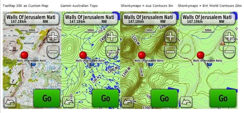
Got the Aus Contours 5m from a fellow walking club member in Hobart.
Here's a quick comparo of different map / contours combos on my Oregon 450.
Here's a quick comparo of different map / contours combos on my Oregon 450.
Re: Contours Aus - anyone got them in Hobart?
Thu 22 Aug, 2013 9:44 am
Interesting comparison. I would be curious to see the Ent_World img as that area has had a bit of OSM mapping done and might be better than Shonkymaps. Just out of curiosity what was your process for loading the Ent_World contours on your Garmin.
Cheers
Cheers
Re: Contours Aus - anyone got them in Hobart?
Thu 22 Aug, 2013 4:21 pm
yes, been thinking that I should have added your full Ent World into the comparo, sorry for not having done that yet, will try tonite
simply copied your img file to the GPS, it then shows with 2 entries in map setup, one of them is contours only
simply copied your img file to the GPS, it then shows with 2 entries in map setup, one of them is contours only
Re: Contours Aus - anyone got them in Hobart?
Thu 22 Aug, 2013 5:47 pm
here are 2 more sets
- GPS Oregon 450 Dixon's Kingdom Maps & Contours 2.jpg (92.15 KiB) Viewed 28492 times
Re: Contours Aus - anyone got them in Hobart?
Fri 23 Aug, 2013 11:59 am
Hi
Thanks for that. Interesting comparing the sets.
Shonky comes from the 1:250,000 data set released by the Federal Government to the public and then refined. Ent_World is OSM data overlaid by SRTM three second (ninety metre) contour data extrapolated to twenty metres. Garmin I am not sure what it uses for contours, tend to think it might be a subset of the SRTM data but maybe the one second (thirty metre) version. The lakes and waterways appear to come from radar mapping as often swamps will show up as bodies of water. Tasmap use land radar with ten metre actual resolution so have by far the best contour data. Lakes for Tasmap I think come from tracing aircraft photographs so should be light years in front of Bing for clarity but having said that Bing is very good at times with huts and tent platforms visible.
For contours and vegetation Tasmap is the best but for an overview Ent_World is not too bad assuming that the tracks have been entered. Garmin is frustrating as generally very good on water features but not a walking track to be found.
Cheers
Re: Contours Aus - anyone got them in Hobart?
Fri 23 Aug, 2013 7:45 pm
Would it be possible to create an OSM map set that has a transparent background to overlay on the Garmin maps? So say an OSM set that does not have the rivers and lakes etc, but does have the tracks, mountains peaks etc to supplement the areas of the Garmin Maps that are lacking?
Re: Contours Aus - anyone got them in Hobart?
Sat 24 Aug, 2013 12:17 pm
sthughes wrote:Would it be possible to create an OSM map set that has a transparent background to overlay on the Garmin maps? So say an OSM set that does not have the rivers and lakes etc, but does have the tracks, mountains peaks etc to supplement the areas of the Garmin Maps that are lacking?
I overlaid the Contours 5M over Gamin's map on my 62S and it worked but that is rather different than OSM data. It might be possible of OSM data can be made transparent but might strike issues as you are using two maps rather than merely contours so have problems with index and routing conflicting. It means that extracts of OSM data will need to be stripped of everything but tracks and huts. Mountains will be a challenge as Garmin has them but in the wrong place and with the wrong names. I will put it on my too do list.
Cheers
Re: Contours Aus - anyone got them in Hobart?
Sun 25 Aug, 2013 4:48 pm
Also got a screenshot of an older OzTopo version from a friend to throw in for comparison ... here's the lot, side by side
- 2013-08-25 2b.jpg (45.81 KiB) Viewed 28395 times
Re: Contours Aus - anyone got them in Hobart?
Sun 25 Aug, 2013 5:51 pm
And there is more! Following sthughes request I extracted from OSM the highway=path, tourism=alpine_hut and tourism=wilderness_hut and proving once again I am a crummy namer call the result, wait for it, Entrails. It is a transparent img so can be overlaid on Garmin maps. Here is the result on my Garmin 62s.
The img has been uploaded onto Ent_World.
Cheers
- Entrails overlaid over Garmin maps.
- Entrails.jpg (26.12 KiB) Viewed 28386 times
The img has been uploaded onto Ent_World.
Cheers
Re: Contours Aus - anyone got them in Hobart?
Sun 25 Aug, 2013 6:31 pm
what a champ!
ta
dq.
ta
Re: Contours Aus - anyone got them in Hobart?
Sun 22 Sep, 2013 7:28 pm
Ent wrote:DonQx wrote:some would disagree
seen this discussion: http://www.gpsaustralia.net/forums/showthread.php?t=7074&s=3f05127e0ca3f195075046b812e7be7e&p=34547#post34547 ?
The base data for Contours Australia comes from the NASA SRTM data that for Australia uses 3 arc (90 metre) measurements. Found out that the Government has access to 1 arc measurement but this is or maybe was for sale only to commercial users and government departments so it is likely that some commercial maps use this. The basic issue with Contours Australia 5M is they convey a degree of precision that they simply do not have. You see nice slopes rather than cliffs. Also they slow down a GPS and result in screen clutter. The one arc set stand a better chance of picking the high points and the extrapolation would be better but I have no idea what commercial products use them. They still would be only "true" thirty metre data. Also I think Tasmap has their own data from years of measurement so nothing can be a Tasmap for find a cliff but they are still guesstimates.
But if you are ever up in Launceston I have them so you can as well. They are around 2GB for Australia. I am working on downloading them direct from NASA in any level needed but as usual struck the geek language barrier. Hopefully some nice German will help me out what I am doing wrong.
. . . .
The basic issue with Contours Australia 5M is they convey a degree of precision that they simply do not have. You see nice slopes rather than cliffs
I also have the 1sec SRTM HDEM data but just doing a quick conversion to vector contours will land you with some crazy data. Any product finalised for on-ground use takes time and effort in ground truthing before it can be useful.
The truth is that beyond a certain scale- asking for topographic data is only armchair bushwalking anyway.
I'm as big a map geek as anyone here (made a career of it) but I still feel that if you cant read the landscape and navigate through it (with a map and compass only for when it's blind or for broad perspective) you shouldn't be out there.
Do you need to know the true extent to the nearest 5 metre of every hill and hummock? Are you planning your walk to the nearest 100m? Are you using a GPS because you expect better accuracy than map or track notes? Are you GPS reading because you can't follow a map / read the landscape? Will the resolution of your data that affect your walk? Can you use vegetation growth, footprint patterns and scats to guess a route?
Venturing beyond the NPWS groomed walking trails requires a degree of skill and the best thing you can do is let go of any reliance mapping/modelling/implied safety and learn your surroundings.
Tassie topo maps are 1:25,000 which is as good as anywhere in Aus (better than most) and as good as you need for anything short of minutia biological surveys or treasure hunting.
More of an issue than resolution is currency. But that's another issue.
You need to be sure you have enough physical capability in reserve to compensate for inaccuracies in your mapping and then some. Don't plan your walk to match exactly your abilities. You will always find the world more challenging than the model. Your GPS won't predict the weather nor factor the condition of the track or your pack weight and can never factor in your overall capability.
Hi-res mapping is great for desktop modelling and tracking past walks (guilty
http://www.brisbanetimes.com.au/travel/travel-news/taking-the-most-direct-route-to-straddie-20120315-1v85m.html
Sorry for the rant - if it applies to you you'll probably ignore it and if it doesn't you'll probably agree and move on.
cheers
Steve
Re: Contours Aus - anyone got them in Hobart?
Mon 23 Sep, 2013 5:29 am
totally agree! thx for your thoughts, nicely stated
Used to run bushnavigation courses for years, based on the "use your grey matter" and habit of "constant thought & observation" philosophy.
Re.
No, bUUUt ... in some more undulating areas, like the Plateau, I wouldn't mind having contours a bit better than 20m based on varying degrees of guesswork. Unlikely to happen in a hurry I presume, but would be nice to end up with fairly good say 10m contours at some stage in the future.
dq.
Used to run bushnavigation courses for years, based on the "use your grey matter" and habit of "constant thought & observation" philosophy.
Re.
Do you need to know the true extent to the nearest 5 metre of every hill and hummock?
No, bUUUt ... in some more undulating areas, like the Plateau, I wouldn't mind having contours a bit better than 20m based on varying degrees of guesswork. Unlikely to happen in a hurry I presume, but would be nice to end up with fairly good say 10m contours at some stage in the future.
dq.
Re: Contours Aus - anyone got them in Hobart?
Mon 23 Sep, 2013 8:31 pm
Back from three day trip up Dixon Track and on to Lake Field then back to the top of Meander Falls. Visibility at the falls often down to ten metres so made experimental path finding challenging and would loved to have had better contours but we gave up on that idea and tracked along and came down a Cained scree field to join up with the Meander Track.
Beauty of OSM and GPS is much easier feature recognition and route planning to dodge scree and creeks. Also to have escape routes if rivers flood as what happened with a local bushwalking club. As always weather can turn and easy walk into a nightmare and no map or device can solve that issue but can give you other options. The better the information the better the options.
The 1 second contours? Are they open source and would you be prepared to share them?
Cheers
Re: Contours Aus - anyone got them in Hobart?
Thu 26 Sep, 2013 10:24 pm
DonQx wrote:totally agree! thx for your thoughts, nicely stated
Used to run bushnavigation courses for years, based on the "use your grey matter" and habit of "constant thought & observation" philosophy.
Re.Do you need to know the true extent to the nearest 5 metre of every hill and hummock?
No, bUUUt ... in some more undulating areas, like the Plateau, I wouldn't mind having contours a bit better than 20m based on varying degrees of guesswork. Unlikely to happen in a hurry I presume, but would be nice to end up with fairly good say 10m contours at some stage in the future.
dq.
DonKee (Oops) Don Qx (sorry)
Not disagreeing with you and am glad you're not a noobee expecting "more data will make the walk easier". I constantly obsess over sourcing better resolution data, but usually only post-walk.
And of course what I meant was "Can you use vegetation growth, footprint patterns and scats and experience and common sense to guess a route" if a map is ambiguous?
PS I like yr avatar.
How do you go around wind farms?
cheers
Steve
Re: Contours Aus - anyone got them in Hobart?
Fri 27 Sep, 2013 12:48 pm
HEE- HAWWH!
Wind farms? ... we have our moments ...
dq.

Wind farms? ... we have our moments ...
Re: Contours Aus - anyone got them in Hobart?
Fri 27 Sep, 2013 1:39 pm
What is the background to that etching?
Re: Contours Aus - anyone got them in Hobart?
Sat 28 Sep, 2013 5:44 am
the novel
http://en.wikipedia.org/wiki/Don_Quixote
Don Quixote ... fully titled The Ingenious Gentleman Don Quixote of La Mancha
http://en.wikipedia.org/wiki/Don_Quixote
Re: Contours Aus - anyone got them in Hobart?
Mon 07 Oct, 2013 2:55 pm
DonQx wrote:HEE- HAWWH!
Wind farms? ... we have our moments ...
Finally! I understand the source of all the complaints!
http://www.telegraph.co.uk/health/healthnews/5963049/Wind-turbines-cause-heart-problems-headaches-and-nausea-claims-doctor.html
Steve
© Bushwalk Australia and contributors 2007-2013.