Forum rules
Tasmania specific bushwalking discussion. Please avoid publishing details of access to sensitive areas with no tracks.Lake Bill Track to Meston
Thu 19 Dec, 2013 10:49 am
Looking for some information on the Lake Bill Track thru to Meston. We are walking in January - can anyone let me know the condition of the track - is it easy to follow?
(I have a map and the track is marked)
Also what is the rough time to walk from Mersey Forest Road to Meston on the track - 5 hours?
I have also heard that camping at Lake Myrtle is good?
Any advice appreciated.
(I have a map and the track is marked)
Also what is the rough time to walk from Mersey Forest Road to Meston on the track - 5 hours?
I have also heard that camping at Lake Myrtle is good?
Any advice appreciated.
Re: Lake Bill Track to Meston
Thu 19 Dec, 2013 11:30 am
I got back yesterday from a walk to Mt Spurling via the Lake Myrtle (Bill) track. It is a very good, easy to follow track. Negligible mud, a brief stretch of button grass just before Lake Bill where the track is less well defined but there's an occasional stick/pole to assist. It took us 3 hours to reach Lake Myrtle at a slow to moderate pace. Very good grassy campsites at Lake Myrtle. We didn't continue directly to Lake Meston as we camped on top of Mt Rogoona, but on the return it took about 1.25 hours to walk from Meston Hut to Lake Myrtle, so 5 hours total seems a good estimate.
Re: Lake Bill Track to Meston
Thu 19 Dec, 2013 11:47 am
Great thanks for the information. Is the trip to top of Mt Rogoona worth while? How long did it take you from the track up to the top? I understand there is no track but do you have any advice on the route?
Re: Lake Bill Track to Meston
Thu 19 Dec, 2013 12:24 pm
Is the trip to top of Mt Rogoona worth while
Definitely in my view.
You look straight down on Lake Myrtle, and the rest of the view is spectacular IMO.
I would recommend that and whilst I can't give you a time it's not that difficult from memory - time or energy wise.
We camped on Rogoona many years back - gorgeous. Well isn't it all back there!
Others will chime in and give you times.
I'd say its a must if you are going past.
Re: Lake Bill Track to Meston
Thu 19 Dec, 2013 12:32 pm
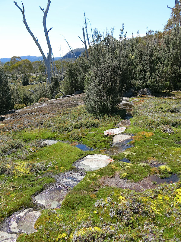
As Taswegian said, definitely worthwhile with lovely views down onto Lake Myrtle and to many nearby peaks. There are two turn offs to the summit. The first is only 10-15 minutes from Lake Myrtle - this route is the best option if approaching from the north with the intention of camping on the summit. It took us about 1.5 hours from there to the summit.
The second turn off is on top of the saddle before starting the descent to Lake Meston.
The photo below shows the main track immediately before the first turn off. After passing through these bushes, look for cairns heading away from the main track on the right:
This is the second turn off at the top the saddle - note the cairn in the middle of the track:

Lake Myrtle from summit:

The second turn off is on top of the saddle before starting the descent to Lake Meston.
The photo below shows the main track immediately before the first turn off. After passing through these bushes, look for cairns heading away from the main track on the right:
This is the second turn off at the top the saddle - note the cairn in the middle of the track:
Lake Myrtle from summit:
Re: Lake Bill Track to Meston
Thu 19 Dec, 2013 5:04 pm
Glad you made the effort to camp on top Rohjoe - it is an amazing place to spend a night.
Re: Lake Bill Track to Meston
Thu 19 Dec, 2013 9:05 pm
It is indeed a very special place to pitch a tent. I was mindful of your suggestion as we headed in Pazzar, and luckily we had plenty of time to reach the summit. 
© Bushwalk Australia and contributors 2007-2013.