Tasman National Park

Tasmania specific bushwalking discussion.
Forum rules
Tasmania specific bushwalking discussion. Please avoid publishing details of access to sensitive areas with no tracks.

Tasman National Park

Postby PeterJ » Fri 01 Jan, 2016 6:52 pm

I have been a supporter of PWS over many years and spent a considerable amount of time and effort in volunteer work on parks. It therefore gives me no pleasure at all to write this complaint about the access to Mount Fortescue and the camping platform for the Cape Pillar walk.

With regard to the Three Capes track I have in general supported the concept and in fact met with Stuart Lennox the then Three Capes project manager in 2007 and worked out what I thought were some acceptable options for existing walkers to Cape Pillar area. At his request I then put this in writing.
However, I was on a walk in the area this week and quite frankly I am disgusted with what PWS has done, and I do not get upset easily. The PWS website currently has under Tasman Peninsula a walk listed to Mount Fortescue via Hauy track, but when I got to the junction with the Cape Hauy track, there was a sign said no entry (due to the spurious excuse of phytophthora). Below is the extract from your website as at time of writing.

On web site http://www.parks.tas.gov.au/index.aspx?base=3876
Mt Fortescue Track
(6-7 hours return)
This track takes walkers to the 490 metre Mt Fortescue and provides excellent views of the rugged coastline. The track commences at Fortescue Bay. Follow the Cape Hauy Track (see above) for about one hour to a low spur where a sign marks the Mt Fortescue Track, which leads off to the right
.

By and large most walkers coming from the Retakunna hut will have reached or be close to the Cape Hauy junction by the time anyone wishing to go to Mount Fortescue reach that point.

I say that the phytophthora is a spurious excuse for stopping people. The very susceptible Banksia marginata is in very good health all the way along the Hauy track, which suggests that the argument is quite spurious and only being used as an excuse no one could come up with a reason that would be acceptable. In any event is not beyond the wit of PWS to construct a better scrub down station or chemical treatment entry gate to replace the very basic one currently existing. How can walkers going one way be not a threat but those the other are? This is all more ridiculous because walkers can start from the exact same Fortescue Bay spot and walk to the Mount Fortescue by the prescribed route, but presumably do not pose a risk of bringing phytophthora that way.

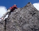
Denying people access to the spectacular cliff lookouts 10-15 minutes up the track, is simply an appalling situation It is truly ridiculous and from observation many other people probably thought the same as several parties (9 people noticed in short period of time) ignored the sign and proceeded up the track. In other words, a walk of under 3 hours return or trip 6:30 to be able to get views from the same point by the designated route.

The other irritant is the placing of the non 3 Capes walker’s campsite at a stupid location. I wonder if whoever decided that spot has ever done an overnight walk to the area. It is about 2 hours walk to the junction with the only designated non 3 capes walker campsite at Wughalee Falls on Retakunna Creek and then 20 minutes downhill to get there (in the opposite direction to where you want to go). From the junction it is about 30 minutes to Lunchtime Creek. The name of the creek should tell you something.

It seems to me that PWS has decided to get nasty to local or non 3 Capes walkers and I feel that it is a real slap in the face to those walkers like myself who have always been happy to share the area. It leaves me quite disgusted with PWS.
IMG_1863 Tunnel Cave.JPG
View 10-15 minutes up the track being denied easy access
IMG_1863 Tunnel Cave.JPG (297.43 KiB) Viewed 9798 times
User avatar
PeterJ
Athrotaxis cupressoides
 
Posts: 428
Joined: Mon 24 Sep, 2007 5:06 pm
Location: Lenah Valley
Region: Tasmania
Gender: Male

Re: Tasman National Park

Postby Beeper » Fri 01 Jan, 2016 9:51 pm

Looks as though the information on the PWS website is not up to date in this area. There seems to be a lot of pages and associated maps on recreation that need some serious revision.
Beeper
Atherosperma moschatum
 
Posts: 76
Joined: Mon 16 Mar, 2009 5:53 pm
Region: Tasmania

Re: Tasman National Park

Postby tastrax » Sat 02 Jan, 2016 4:36 pm

OK Peter, lets give PWS a hand here. How far along the Mt Fortescue Track do you think you should be able to go on a daywalk from Fortescue Bay? (assuming we can get over the Phytophthora issue which I know nothing about at this stage). What is a reasonable location for the "No Day tripping beyond this point? Which square in the attached image?

HowFarAlong.JPG
How far ?
Cheers - Phil

OSM Mapper
User avatar
tastrax
Lagarostrobos franklinii
 
Posts: 2032
Joined: Fri 28 Mar, 2008 6:25 pm
Location: What3words - epic.constable.downplayed
ASSOCIATED ORGANISATIONS: RETIRED! - Parks and Wildlife Service
Region: Tasmania

Re: Tasman National Park

Postby PeterJ » Sat 02 Jan, 2016 5:41 pm

tastrax wrote:.... How far along the Mt Fortescue Track do you think you should be able to go on a daywalk from Fortescue Bay?


The walk should go to the top as described in the PWS website description, which is AGD66 578531 5219457 or square 54.
User avatar
PeterJ
Athrotaxis cupressoides
 
Posts: 428
Joined: Mon 24 Sep, 2007 5:06 pm
Location: Lenah Valley
Region: Tasmania
Gender: Male

Re: Tasman National Park

Postby pazzar » Sat 02 Jan, 2016 8:57 pm

How long is a day walk though? I don't think it can be limited to just a point on a map.

I'm not well read on the ins and outs of the new rules, but I was under the impression that the whole park would still be open for day walks. Surely that means that I could go for a walk for 12 hours (or 24 I guess!), which would get me well past that point on the track if I wished to do so. If this is not the case, then we need a definitive statement outlining exactly what can and cannot be done.

Does this also impact on the Cape Pillar track? If I wanted to walk or run this as a day trip, am I breaking rules in order to do this? I don't want to lose this part of the state as a walking destination, but I will never pay money to complete a hut based walk.
"It's not what you look at that matters, it's what you see."
User avatar
pazzar
Lagarostrobos franklinii
 
Posts: 2657
Joined: Thu 09 Jul, 2009 5:22 pm
Location: Hobart
Region: Tasmania
Gender: Male

Re: Tasman National Park

Postby DanShell » Sat 02 Jan, 2016 10:06 pm

At the moment the track must be walked in an anti clockwise direction.
You can walk the whole track in a day if you wish but you must enter it via the inland track.
If you want to go to the top of mount fortescue you can't do it from the Hauy end.
We walked into the camp ground at Whugalee via the inland track late one afternoon and then went down to cape pillar and walked out over mount fortescue all the following day because the thought of getting eaten alive by the mozzies another night a Whugalee was enough to make us walk the 30 kays out on the second day.
The track no longer goes up over fortescue via Whugalee falls it goes around them to go over the mountain but not before you must walk through one of the mini towns they have built.
User avatar
DanShell
Athrotaxis selaginoides
 
Posts: 1200
Joined: Mon 18 Mar, 2013 11:23 am
Location: Central
Region: Tasmania
Gender: Male

Re: Tasman National Park

Postby Happy Wanderer » Sun 03 Jan, 2016 8:31 am

The Phytophthera argument for closing access to Mt Fortescue from the Cape Hauy track doesn't add up. If the pathogen is on the Cape Hauy track, restricting access towards Mt Fortescue still means the entire Cape Hauy track is exposed. If it is on the Mt Fortescue track, restricting access one way only still means that Three Capes walkers will spread it along the Mt Fortescue track and onto the Cape Hauy track where it will be spread along the length of that track. Along with other contributors here, I suspect this may be a red herring designed to deflect day walkers from using their long-established access to Mt Fortescue from the Cape Hauy track.
Happy Wanderer
Nothofagus gunnii
Nothofagus gunnii
 
Posts: 17
Joined: Mon 04 Mar, 2013 2:39 pm
Region: Tasmania
Gender: Female

Re: Tasman National Park

Postby tastrax » Sun 03 Jan, 2016 12:45 pm

In general the idea with simple Phytophthora management is to ensure that walkers are first walking in "clean zones" before walking into "infected zones". There is also a desire to prevent spread into new catchments/watersheds. If the Cape Hauy area is infected but not out towards Mt Fortescue or the cape then I can understand why they want a restricted walk direction.

Has anyone read this document in details? I haven't but it may give some clues?

http://dpipwe.tas.gov.au/Documents/Inte ... elines.pdf

Unfortunately Phytophthora infection data is not on LIST maps as far as I can see.
Cheers - Phil

OSM Mapper
User avatar
tastrax
Lagarostrobos franklinii
 
Posts: 2032
Joined: Fri 28 Mar, 2008 6:25 pm
Location: What3words - epic.constable.downplayed
ASSOCIATED ORGANISATIONS: RETIRED! - Parks and Wildlife Service
Region: Tasmania

Re: Tasman National Park

Postby tastrax » Sun 03 Jan, 2016 12:55 pm

Does all this also mesh with the Phytophthora Management Plan for the Tasman National Park

http://www.parks.tas.gov.au/file.aspx?id=25673
Cheers - Phil

OSM Mapper
User avatar
tastrax
Lagarostrobos franklinii
 
Posts: 2032
Joined: Fri 28 Mar, 2008 6:25 pm
Location: What3words - epic.constable.downplayed
ASSOCIATED ORGANISATIONS: RETIRED! - Parks and Wildlife Service
Region: Tasmania

Re: Tasman National Park

Postby tastrax » Sun 03 Jan, 2016 4:01 pm

If the real reason for one way travel is because of Phytophthora, then these are the documents that you will need to pick through and make a case that there is no threat of Phytophthora ingress by walkers going to Mt Fortescue from the Cape Hauy track. You may also be able to make a case of further travel as well depending on what is in them.
Cheers - Phil

OSM Mapper
User avatar
tastrax
Lagarostrobos franklinii
 
Posts: 2032
Joined: Fri 28 Mar, 2008 6:25 pm
Location: What3words - epic.constable.downplayed
ASSOCIATED ORGANISATIONS: RETIRED! - Parks and Wildlife Service
Region: Tasmania

Re: Tasman National Park

Postby PeterJ » Mon 04 Jan, 2016 8:19 am

I have read what seemed to be the appropriate parts of the Phytophthora Management Plan for which tastrax provide the link.

Basically it indicates that a “small area near Cape Hauy only” and that the management actions for protect uninfected communities is for “Sections of track through high susceptible coastal heathland to be hardened”, which has already been done.
User avatar
PeterJ
Athrotaxis cupressoides
 
Posts: 428
Joined: Mon 24 Sep, 2007 5:06 pm
Location: Lenah Valley
Region: Tasmania
Gender: Male

Re: Tasman National Park

Postby daywalkertas » Thu 07 Jan, 2016 7:24 pm

Excellent post PeterJ, agree with all you have posted.

Over the years I have walked all sections of this track (old/new) with the exception of the Retakunna jct to Cape Pillar section.

Parks seem to be missing the point with their engagement with some of their greatest supporters ie the Tasmanian day walking community whom by and large have supported the Three Capes concept, albeit with consistent re-assurances that our legacy rights of access would not be diminished.

Let's cut to the chase, the one way system is more to do with commercialisation than phytophthora management. Reading back through all the documentation, Parks have part justified the expense of the track by stating the width and quality would eliminate the need for passing walkers to step off the track.

A case in point is the 'new' access to Arthurs Peak from Fortescue via the original Cape Pillar track via the original Arthurs Peak ( unmaintained and de-marked) thence return on part of Three Capes to Retakunna Jct and back on original Cape Pillar track or via new Mount Fortescue section. How could phytophthoral management be reduced by two way traffic over the section from Retakunna jct to Arthurs Peak rather than potential dragging of infection over an old boggy and unmaintained track?

Parks are scrambling to make good their assurances that camping pads would be provided in existing locations for overnight walkers.

Let's hope common sense prevails, we may even be offered commercial access to the Denmans Cove ferry and bus return to Port Arthur, thus providing some extra revenue to Parks and assisting their cost problem.
daywalkertas
Nothofagus cunninghamii
 
Posts: 2
Joined: Thu 07 Jan, 2016 6:49 pm
Region: Tasmania
Gender: Male


Return to Tasmania

Who is online

Users browsing this forum: No registered users and 57 guests