Forum rules
Forum rulesThis is a place to share fair and systematic reviews of gear. Share the good, bad and ugly as well as including how you tested it and reviewed the gear. This is not the place to carry on about a bit of gear that failed, sometimes good gear has a lemon - this is more about systematic reviews. Although this can be a way to help gear manufactures with feedback, this is not the place to hassle them or ask for money back.
Start each thread with
[tag]Brand, product, RRP in AUD. The tags have two parts the type of gear and type of testing/review. eg
[Sleeping bag | Unboxing] Kmart Summit Hooded $29
[Stove | Field test]Jetboil, flash $150
Suggested review types. Unboxing, field test, 1 year on, stress test, teardown.
If someone else has already reviewed the same product in a similar method then please use the initial thread to include your review. Please note if the gear was provide to you for free, loan, discount or if you paid full RRP.
Garmin's topo map accuracy (or lack of)
Fri 19 Feb, 2016 3:22 pm
Re: Garmin's topo map accuracy (or lack of)
Fri 19 Feb, 2016 6:31 pm
Woah. I would love to see a similar comparison for OSM.
Sent from my SM-N9005 using Tapatalk
Sent from my SM-N9005 using Tapatalk
Re: Garmin's topo map accuracy (or lack of)
Fri 19 Feb, 2016 8:20 pm
Strider wrote:Woah. I would love to see a similar comparison for OSM.
Sent from my SM-N9005 using Tapatalk
OSM has no contour data.
Open cycle Map uses SRTM data which is as bad (or worse).
Andrewa's maps use Australian 25k topo contours and are by far the best.
Have a look at Garmins topo of tas - all the peak names are moved off by a couple of km.
Re: Garmin's topo map accuracy (or lack of)
Sat 20 Feb, 2016 8:03 am
Ah yes, of course. I am using Andrewa's maps with the 10m intervals and have found them extremely accurate to date 
Sent from my SM-N9005 using Tapatalk
Sent from my SM-N9005 using Tapatalk
Re: Garmin's topo map accuracy (or lack of)
Wed 24 Feb, 2016 7:09 pm
Strider wrote: I would love to see a similar comparison for OSM.
Here you go - comparing the same locations as per Wild's article but comparing my Garmin V4 and Andrew's OSM. For ease of reference I have also linked the Wild comparison. Apologies for the different scales - I already had the NSW OSM on my android tablet so used Orux for the screencaps instead of copying to my Garmin Oregon.
Wild's Capertree:
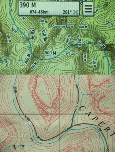 Bigger version http://wild.com.au/wp-content/uploads/2 ... arison.jpg
Keithy's V4/OSM:
Wilds Wolgan
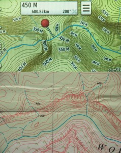 Bigger http://wild.com.au/wp-content/uploads/2 ... Wolgan.jpg
Keithy's V4/OSM:
Wild's Colo River
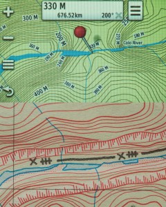 Bigger http://wild.com.au/wp-content/uploads/2016/02/Colo.jpg
Keithy's V4/OSM:
There definitely is some contour errors that appear introduced in the V5 that were not present in the V4. But the comparison with the NSW OSM that andrewp compiled is pretty sparse and obviously equally incorrect when comparing with the NSW 1:25000 1977 topo that Wild illustrates. I've found the VIC OSM to be pretty good with contours and hydro as per state sources.
I would be curious to hear Garmin's response. Without people reporting this, there could be introduced errors due to contour smoothing models used. You can that the OSM topos don't apply smoothing and the hydro courses are missing or inaccurately located on the OSM as well.
FWIW I've not seen cliff markings on any vector topo maps yet. I've seen them on scanned digital topo maps. And in some markets Garmin uses scanned topo maps - like the UK Discoverer GB series which uses scanned Ordance Survey maps.
Re: Garmin's topo map accuracy (or lack of)
Thu 25 Feb, 2016 12:51 pm
keithy wrote:FWIW I've not seen cliff markings on any vector topo maps yet.
Now you have! This screenshot is from OsmAnd with the contours plugin, on a Samsung Galaxy Note 3.
OsmAnd uses Open Street Map data and, unlike many apps, does render the clifflines. Admittedly, the cliff markings are rudimentary and the contours are not great. But hey, those things are only going to get better, and this is a genuine offline vector map that displays both contours and clifflines.
Re: Garmin's topo map accuracy (or lack of)
Thu 25 Feb, 2016 4:51 pm
ribuck wrote:Now you have! This screenshot is from OsmAnd with the contours plugin, on a Samsung Galaxy Note 3.
I should have been clearer in that I meant I haven't seen cliff renderings in Garmin formatted IMG vector maps.
I also have bought OSMAnd+ to support the developer, but don't use it much as it doesn't support IMG map files. I didn't buy the Contours and Map shading add-in pack though.
I know that Oruxmaps that I am using can also display cliff renderings in mapsforge map formats. I have the Tobias' Elevate 3 theme http://www.openandromaps.org/en/legend/ ... hike-theme that shows the cliff and rock faces as:
 .
. But I've not used mapsforge maps in a while - I'll have to grab the Aust OSM mapsforge again and see if it shows cliff renderings.
On your OSMAnd can you go to the Colo Rivers Gorges as per the Wild article and see if it displays the cliff faces? (56H KJ707213) (WGS84) or 33.2229 S 150.5395 E.
Another question, to save me installing OSMAnd+ and downloading maps to check, with OSMAnd can you now enter UTM/MGRS grid references? When I had it installed I couldn't find a way to do this.
Re: Garmin's topo map accuracy (or lack of)
Thu 25 Feb, 2016 9:19 pm
Hi Keithy,
OsmAnd doesn't display any clifflines along the Colo river, simply because none are present in the OSM database. So if anyone is looking for a mapping project...
Also I don't know any way to enter a grid reference into OsmAnd. You need to convert the grid reference to Lat/Lon first.
OsmAnd doesn't display any clifflines along the Colo river, simply because none are present in the OSM database. So if anyone is looking for a mapping project...
Also I don't know any way to enter a grid reference into OsmAnd. You need to convert the grid reference to Lat/Lon first.
© Bushwalk Australia and contributors 2007-2013.