Forum rules
Only administrators may post new topics to this forum. Registered users can post replies.Re: GAME: Where Am I? (Continued)
Fri 04 Dec, 2009 2:03 pm
ff
Re: GAME: Where Am I? (Continued)
Fri 04 Dec, 2009 2:05 pm
My only time to Frenchmans & look at the conditions we got, terrible
There wasn't even a breath of wind to cool ourselves by.
over to you...
Re: GAME: Where Am I? (Continued)
Fri 04 Dec, 2009 2:40 pm
Re: GAME: Where Am I? (Continued)
Fri 04 Dec, 2009 2:45 pm
i entered a pic sorta like that in the comp couple of months ago
Re: GAME: Where Am I? (Continued)
Fri 04 Dec, 2009 3:00 pm
ff
Re: GAME: Where Am I? (Continued)
Fri 04 Dec, 2009 3:11 pm
Re: GAME: Where Am I? (Continued)
Fri 04 Dec, 2009 3:40 pm
Never seen Anne from around Gretna.....hmmmm interesting....
Hows about, the Jubilee range? Mt Jubilee?
Re: GAME: Where Am I? (Continued)
Fri 04 Dec, 2009 4:22 pm
ff
Re: GAME: Where Am I? (Continued)
Fri 04 Dec, 2009 4:27 pm
Re: GAME: Where Am I? (Continued)
Fri 04 Dec, 2009 4:40 pm
Maybe Tanina Bluff or Taylors Tier?
Re: GAME: Where Am I? (Continued)
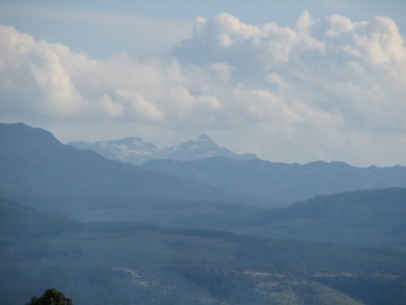
Fri 04 Dec, 2009 4:51 pm
I was driving through from Elderslie and noticed a track heading off uphill into a plantation so went for a sticky.
We drove to a knob 753m elevation about 1k nw of Tanina bluff. Better than expected view but Mt. Anne was far away and only a compact digital so not a real good pic.
Still thought it worth a quick snap. The Snowy range is also quite visible from there.
Your go sbs , well done.
ff
Re: GAME: Where Am I? (Continued)
Fri 04 Dec, 2009 5:04 pm
Thanks to Google Earth for that one! I can see the road NW of Tanina
This is tourist central, a great spot though.....most people face the other way!
sbs
- Attachments
-
Re: GAME: Where Am I? (Continued)
Fri 04 Dec, 2009 9:39 pm
a clue, a photo from a protein rich forum member was posted from the same spot, you could almost stitch this one to it....
nighty night
Re: GAME: Where Am I? (Continued)
Sat 05 Dec, 2009 8:58 pm
But another lovely weekend dawns and it is a little quiet again.
Being protein rich I thought I should put up the panorama to help...
Re: GAME: Where Am I? (Continued)
Sat 05 Dec, 2009 9:17 pm
Very quiet this weekend, you've been away a while, walking I hope?
Re: GAME: Where Am I? (Continued)
Sat 05 Dec, 2009 9:20 pm
need to get a new batch in January - woohoo
Re: GAME: Where Am I? (Continued)
Sun 06 Dec, 2009 6:03 am
NE Ridge of Anne, hey eggs - I'm hoping for the same trip sometime in Jan also....can't wait.
If someone gets it, just carry on....it's a great short walk.
Re: GAME: Where Am I? (Continued)
Sun 06 Dec, 2009 6:28 am
I remember the discussion about the person in the foreground on the left.
Re: GAME: Where Am I? (Continued)
Sun 06 Dec, 2009 8:33 pm
I'm sure someone has been somewhere far more enticing this weekend.....so let's see a photo and keep the game going.....
Where were you?
Re: GAME: Where Am I? (Continued)
Sun 06 Dec, 2009 9:23 pm
So where is it from
ff
Re: GAME: Where Am I? (Continued)
Mon 07 Dec, 2009 7:05 am
I took a drive up from the Midlands Highway, through Interlaken and out via Golden Valley, and have gone through via Bothwell a couple of times.
I suspect there is a lake with a fishing line dangling in it if you were facing the other way
In short, Dunno.
Re: GAME: Where Am I? (Continued)
Mon 07 Dec, 2009 8:44 am
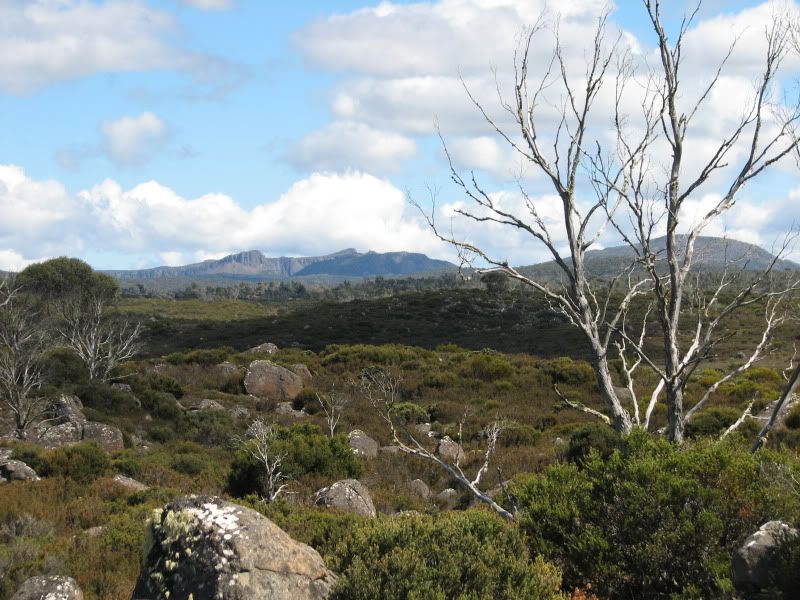
We are booked for a 5 day walk through here in early Jan, so this one is a good photo for setting the scene.
The peaks at the back are Solomons Throne, King Davids Peak [I used to call it the Western Wall??] the Temple & Mt Jerusalem
Now I just need to look at a map to work back on the angles.
Re: GAME: Where Am I? (Continued)
Mon 07 Dec, 2009 11:59 am
eggs wrote:The peaks at the back are Solomons Throne, King Davids Peak [I used to call it the Western Wall??] the Temple & Mt Jerusalem
Now I just need to look at a map to work back on the angles.
Of course, I can recognise King Davids Peak & Solomons Throne, I'm always forgetting how close things appear via the straight line.
Maybe around Talleh lagoons or Lake Fanny?
Re: GAME: Where Am I? (Continued)
Mon 07 Dec, 2009 8:48 pm
Its an area I've been to heaps of times for fishing, I love it out there.
Your go mate.
ff
Re: GAME: Where Am I? (Continued)
Mon 07 Dec, 2009 8:52 pm
Re: GAME: Where Am I? (Continued)
Mon 07 Dec, 2009 9:01 pm
Just take the road from Liawenee to Lake Augusta and follow it to the car park at Lake Ada, then walk the old four wheel drive track which heads towards the WOJ.
Plenty of nice camp spots at places like Lake Fanny, Talleh Lagoons etc. Pillans and Ada 25k maps show tracks, huts etc. Check it out!
ff
Re: GAME: Where Am I? (Continued)
Mon 07 Dec, 2009 10:05 pm
flyfisher wrote:Do yourself a favour Adam, go and have a look. In January all the wildflowers will be out and there are heaps of mini gardens out there with lots of photo opportunities.
Just take the road from Liawenee to Lake Augusta and follow it to the car park at Lake Ada, then walk the old four wheel drive track which heads towards the WOJ.
Plenty of nice camp spots at places like Lake Fanny, Talleh Lagoons etc. Pillans and Ada 25k maps show tracks, huts etc. Check it out!
ff
That does a lot to put me in the picture of where the photo was... Which is good because I was too lazy to pull the map out.
Thanks.
Yes, I know of the road but haven't been down it any more than a few hundred metres at Liawenee.
Must do that one day.
Re: GAME: Where Am I? (Continued)
Tue 08 Dec, 2009 7:40 am
Back online - anyone else just lose BWT for half an hour?
I too haven't had time for a sticky down that road from Liawenee, looks like great country.
This one is from a great walk not far from home, slightly off track, just name the feature I'm close too.
sbs
- Attachments
-
Re: GAME: Where Am I? (Continued)
Tue 08 Dec, 2009 8:06 am
Looks like you're too high up for Silver Falls to be close.
Re: GAME: Where Am I? (Continued)
Tue 08 Dec, 2009 8:09 am
the rocks are perfectly identified, but not The Springs or Silver Falls
© Bushwalk Australia and contributors 2007-2013.