It will probably take quite a while for full details to be discovered and information gathered on how much damage the Western Tiers sustained during the recent floods. I thought I would start the ball rolling by letting you know what I have heard from locals or gone and looked at myself. Please feel free to add your own knowledge as further things come to light.
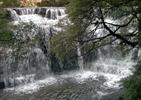
- There have been at least seven large landslips on the Western Tiers face in the last fortnight, from Mother Cummings Peak to Western Bluff. Some of these are in areas that will not affect walkers. At least one track is completely destroyed and possibly even the feature that track went to - namely Westmoreland Falls - the locals have not yet been able to determine if the falls still exist or in fact exactly where the creek goes now as a whole new gorge has been created. Several creeks have changed their courses as the usual karst system creeks that flow underground have been clogged with debris and silt - some possibly permanently.
- The wet caves system may have significant damage (could someone with more info let us know)
- Stone Hut, Bastion Cascades, etc, right through to Meander Falls and Dixons Track is not currently accessible as both bridges have been destroyed on the access road. Not sure how long they will take to fix this, but unless there is still a need to access logging coups it may not be a priority. This also begs the question of how all these tracks have fared considering the damage downstream, uprooted trees, completely changed watercourses, masses of debris that came down the mountains.
- At least two of the landslips are visible from Deloraine i.e. they are several hundred metres wide and quite long! One of the most siginifcant is visible from South Mole Creek Rd and appears to be in the vicinity of Western Creek track, maybe somewhere to the left - starts at approx. 800 metres elevation and it is at least 500metres or more long and I'm not sure what it has taken with it, track or roadwise - I will hopefully investigate next week. It looks like it may well have reached Western Creek itself.
As more information comes to light I will add here - hopefully others will do the same. There may be significant track work to be done, if anyone is interested in helping.
There are some interesting articles on the ABC website and an old report about previous landslips in the area by Laurie Goldsworthy on the internet if anyone is feeling like a good read.
Western Tiers Damage to tracks
Forum rules
Tasmania specific bushwalking discussion. Please avoid publishing details of access to sensitive areas with no tracks.
Tasmania specific bushwalking discussion. Please avoid publishing details of access to sensitive areas with no tracks.
8 posts
• Page 1 of 1
Western Tiers Damage to tracks
![]() by whiskeylover » Thu 27 Jan, 2011 6:06 am
by whiskeylover » Thu 27 Jan, 2011 6:06 am
medicinal purposes only of course
-
whiskeylover - Athrotaxis cupressoides

- Posts: 178
- Joined: Fri 27 Jun, 2008 8:05 pm
- Location: Deloraine
- Region: Tasmania
Re: Western Tiers Damage to tracks
![]() by whiskeylover » Thu 27 Jan, 2011 6:28 am
by whiskeylover » Thu 27 Jan, 2011 6:28 am
A not very good phone picture of the first bridge out (Smoko Creek I think)
The second bridge is also gone but the picnic ground and buildings are all still intact.
The second bridge is also gone but the picnic ground and buildings are all still intact.
medicinal purposes only of course
-
whiskeylover - Athrotaxis cupressoides
- Posts: 178
- Joined: Fri 27 Jun, 2008 8:05 pm
- Location: Deloraine
- Region: Tasmania
Re: Western Tiers Damage to tracks
![]() by Bap » Thu 27 Jan, 2011 6:41 am
by Bap » Thu 27 Jan, 2011 6:41 am
Last Week I drove up Westrope Road where the Western Creek Bridge is down. I walked up to Syds Track to Ironstone Mt then back down the Western Creek Track both of which are in top condition with hardly any damage to either track.
It is easier to go down a hill than up, but the view is much better at the top.
-

Bap - Phyllocladus aspleniifolius

- Posts: 549
- Joined: Thu 25 Mar, 2010 8:26 pm
- Location: Hobart
- Region: Tasmania
- Gender: Male
Re: Western Tiers Damage to tracks
![]() by Thomas » Thu 27 Jan, 2011 2:55 pm
by Thomas » Thu 27 Jan, 2011 2:55 pm
Hey Whiskeylover....
To add a little info....
On Sunday 23rd January, myself & another 5 persons completed a day walk to Lake Nameless via Higgs Track. I do plan on a full report very soon, but will say that for parties using Higgs Track please be advised that the old log bridge over Dale Brook Creek has been washed away...rock hopping is needed to cross. Water levels had returned to normal when we were there.
As for Higgs track ascent to the plateau, it has sustained a little damage in places. The water has cut quite a path approximately half way up.
Apart from that, it seems to have faired reasonably well. Track is still easily usable.
As stated, i will post a report soon with some pics. Hope this info has been helpful...
Regards,
Thomas
-

Thomas - Athrotaxis cupressoides
- Posts: 130
- Joined: Wed 14 Jul, 2010 8:41 am
- Region: Tasmania
- Gender: Male
Re: Western Tiers Damage to tracks
![]() by GerryDuke » Thu 27 Jan, 2011 5:21 pm
by GerryDuke » Thu 27 Jan, 2011 5:21 pm
Thanks Whiskylover. It is scary what might have happened up there. I tried to ring the local parks office last week but didn't get an answer at the time.
http://www.parks.tas.gov.au/index.aspx? ... intID=2165
Gerry
http://www.parks.tas.gov.au/index.aspx? ... intID=2165
Gerry
-
GerryDuke - Athrotaxis cupressoides
- Posts: 427
- Joined: Sun 18 May, 2008 12:04 am
- Location: KINGSTON BEACH, TASMANIA
- Region: Tasmania
- Gender: Male
Re: Western Tiers Damage to tracks
![]() by taswegian » Fri 28 Jan, 2011 6:45 pm
by taswegian » Fri 28 Jan, 2011 6:45 pm
here's a bit from ABC
http://www.abc.net.au/rural/tas/content/2011/01/s3120414.htm
http://www.abc.net.au/rural/tas/content/2011/01/s3120414.htm
-
taswegian - Phyllocladus aspleniifolius
- Posts: 899
- Joined: Tue 27 Jul, 2010 8:34 pm
- Region: Tasmania
- Gender: Male
Re: Western Tiers Damage to tracks
![]() by shazcol » Sun 30 Jan, 2011 7:17 pm
by shazcol » Sun 30 Jan, 2011 7:17 pm
Had a drive out that way today. Worth a trip to look at some of the damage and where the water has been and undermined and moved bridges and changed the route of creeks. About seven landslips on the tiers are very visible. A very large one to the South of the Parsons track start is huge.
Damaged bridge on Westrope Road. Looking underneath it has been undermined by the water and one end of the log that holds it is sitting on a small rock up in the air. The other end of that log has just had everything under it washed away. The bridge has quite a lean now.
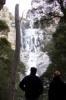
It must still be possible to get into the Meander Falls area by other means as these three vehicles are on the Meander Falls side, after both washed away bridges. I hope we can find it soon to save a bit of boring walk on the old road.
Quite a bit of damage at Wet Caves where what was Westmorland falls came gushing across the paddocks and made a couple of new entries into the cave area. A lot of fences in that area have debris on them.
Damaged bridge on Westrope Road. Looking underneath it has been undermined by the water and one end of the log that holds it is sitting on a small rock up in the air. The other end of that log has just had everything under it washed away. The bridge has quite a lean now.
- Western Creek Bridge out
- WesternCreekBridge2.jpg (21.8 KiB) Viewed 4407 times
- Western Creek Bridge on a lean
- WesternCreekBridge.jpg (64.1 KiB) Viewed 4407 times
It must still be possible to get into the Meander Falls area by other means as these three vehicles are on the Meander Falls side, after both washed away bridges. I hope we can find it soon to save a bit of boring walk on the old road.
- Meander second bridge
- MeanderSecondBridge.jpg (53.73 KiB) Viewed 4407 times
Quite a bit of damage at Wet Caves where what was Westmorland falls came gushing across the paddocks and made a couple of new entries into the cave area. A lot of fences in that area have debris on them.
If common sense is so common, why don't you see more of it?
-

shazcol - Athrotaxis cupressoides
- Posts: 459
- Joined: Mon 11 Jun, 2007 9:25 pm
- Location: Launceston
- Region: Tasmania
Re: Western Tiers Damage to tracks
![]() by whiskeylover » Thu 03 Feb, 2011 9:58 am
by whiskeylover » Thu 03 Feb, 2011 9:58 am
Yes, it is still possible, preferably with 4WD to access the Meander Falls and Split Rock tracks, but I am in two minds about posting details here as the track we used has a couple of short sections that would deteriorate quickly with much use, especially if people do it in a 2wd which would currently be possible with care. I have heard that Greg Hall MLC has said there is no money available to replace the bridges, but I'm hoping to lobby for a bit of gravel to be dumped on this other access. That and a couple of signs to show the way would be all it would take.
The Apex Hut and surrounds is fine. The suspension bridge on the split rock track is also fine, just has a couple of saplings wedged up against it, but not enough to damage it. Amazing how the river looks cleaned out - all the overhanging shrubbery gone, boulders in different places and banks undercut. Haven't had time to actually go up any of the tracks.
Unfortunately the Quarry Road which gives you access to Bastion Cascades, Stone Hut Circuit is in between the two washed out bridges so a mountain bike would probably be the best option there now, to get you up to the start of the track, (nice steep hill in there too). Smoko Creek is easily crossable, although you might get your feet wet.
No time to check out the other tracks and accesses at the moment - maybe next week.
medicinal purposes only of course
-
whiskeylover - Athrotaxis cupressoides
- Posts: 178
- Joined: Fri 27 Jun, 2008 8:05 pm
- Location: Deloraine
- Region: Tasmania
8 posts
• Page 1 of 1
Who is online
Users browsing this forum: No registered users and 33 guests