Forum rules
Tasmania specific bushwalking discussion. Please avoid publishing details of access to sensitive areas with no tracks.Mt Solitary, SW Tasmania
Wed 05 Jan, 2011 4:07 pm
I am in the process of planning a kayak/walk to this summit. Can anyone give me some info on paddling times/best route to island and summit/walking time/anything????
I have heard it's a little snakey, and have read this account http://www.wildtigertasmania.com/2006/0 ... -trip.html interesting to see wildtiger format has changed, I thought this site was no longer being updated?
Any help much appreciated....
- Attachments
-
Re: Mt Solitary, SW Tasmania
Wed 05 Jan, 2011 4:18 pm
Re: Mt Solitary, SW Tasmania
Wed 05 Jan, 2011 4:58 pm
Re: Mt Solitary, SW Tasmania
Thu 06 Jan, 2011 2:18 pm
Re: Mt Solitary, SW Tasmania
Thu 06 Jan, 2011 2:27 pm
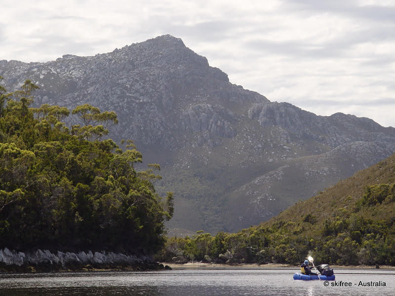
Is that Mt Rugby??
Packrafts are cool, but they are fairly expensive.
Re: Mt Solitary, SW Tasmania
Thu 06 Jan, 2011 3:16 pm
Re: Mt Solitary, SW Tasmania
Thu 06 Jan, 2011 3:25 pm
Yeh im considering taking my 3 man raft for an overnighter if nothing else comes up by next summer...
Re: Mt Solitary, SW Tasmania
Thu 06 Jan, 2011 3:38 pm
The ridge we went up was pretty good, but the trick we found on descent was don't stick to the ridgeline. Stay to the western side of the ridgeline on the way up and you stay clear of some crud.There is also a bit of scunge in the plains area.
IIRC it took about 3.5 hours, and I was not fit at the time. I recall 2:02 up, and less down.
- Attachments
-
- Capture.JPG (213.57 KiB) Viewed 11222 times
Re: Mt Solitary, SW Tasmania
Thu 06 Jan, 2011 4:01 pm
Times equate to other beta.
Nice pic of Rugby Wander - mid to late Feb for me
Re: Mt Solitary, SW Tasmania
Sat 08 Jan, 2011 8:37 am
Re: Mt Solitary, SW Tasmania
Sat 08 Jan, 2011 12:08 pm
All I really want to know now is where people have launched their kayaks from and their approximate paddling times.
I'm assuming Scotts Peak Dam would be the logical spot, many thanks.
Re: Mt Solitary, SW Tasmania
Mon 24 Jan, 2011 1:01 pm
I measure the water leg to be about 8 km's from the Scotts Peak Dam boat ramp to the southern side of Solitary (roughly one of the bays you highlighted). From my experience at Lake St Clair it would take me about 2 hours to paddle. All predicated of course on conditions on the water being reasonable - minimal to no wind.
Cheers
Andrew
Re: Mt Solitary, SW Tasmania
Mon 24 Jan, 2011 2:00 pm
abowen wrote:All predicated of course on conditions on the water being reasonable - minimal to no wind.
Andrew
We are talking about Pedder here..... Still it does happen, just not often, or all day. At least if/when the wind does pick up later in the day it'll be a tailwind....
Re: Mt Solitary, SW Tasmania
Tue 25 Jan, 2011 9:08 am
abowen wrote:Hi Dan,
I measure the water leg to be about 8 km's from the Scotts Peak Dam boat ramp to the southern side of Solitary (roughly one of the bays you highlighted). From my experience at Lake St Clair it would take me about 2 hours to paddle. All predicated of course on conditions on the water being reasonable - minimal to no wind.
Cheers
Andrew
Those times equate closely to what I have heard, about 7-8 hrs round trip with lunch up top and some breaks there may just be time to duck up Scotts Peak on the way back
Re: Mt Solitary, SW Tasmania
Wed 26 Jan, 2011 1:07 pm
i'm plannin a trip that way too.... seen this?: viewtopic.php?f=15&t=5739&p=68551&hilit=kayak#p68551
have fun... be good to hear how ya go!
Re: Mt Solitary, SW Tasmania
Sun 30 Jan, 2011 12:11 pm
We just got back from there, nothing really to add. Scotts Peak best place to launch, more sheltered than Edgar. We looked to see if there was an old 4WD track opposite Anne to launch from but could not find it. A couple of hours paddling over there into the wind.We went up on the ridge to the right of Oli's pic but back down the ridge Oli went up on, its better, clearer, more direct. Only saw 2 whip snakes, although I did nearly tread on one! 7-8 hours for the day sounds about right. We camped there so all was done at an easy pace.
Enjoy!
Amanda
Re: Mt Solitary, SW Tasmania
Sun 30 Jan, 2011 12:33 pm
Last piece to the puzzle....had heard conflicting stories about paddling times and we have a small flotilla organised, so assume we will have a slowish pace, will be happy if we can all do it within 10hrs.
Heard you and Jez got a kayak, new adventures hey?
Thanks again!
Re: Mt Solitary, SW Tasmania
Sun 30 Jan, 2011 1:10 pm
Re: Mt Solitary, SW Tasmania
Thu 24 Feb, 2011 1:26 pm
Will attempt again as a 'flashwalk' sometime. I'm afraid it won't be until next season though.....
Re: Mt Solitary, SW Tasmania
Thu 24 Feb, 2011 1:46 pm
Re: Mt Solitary, SW Tasmania
Thu 24 Feb, 2011 2:05 pm
Liamy77 wrote:damn.... better luck then i hope
Yup thought booking a date in mid-Feb would give us some hope, but alas it was not meant to be!
Re: Mt Solitary, SW Tasmania
Thu 24 Feb, 2011 2:27 pm
Re: Mt Solitary, SW Tasmania
Thu 17 Mar, 2011 1:22 am
Amanda wrote:<Snip>I'll put some photos up at some stage.
Look forward to seeing your photos from Solitary, Amanda
Re: Mt Solitary, SW Tasmania
Mon 27 Feb, 2012 9:02 am
- Attachments
-
- Mt Solitary from Scotts Peak shoreline
-
- On the way up with The Barrier Islands
-
- 180 degree summit view
Re: Mt Solitary, SW Tasmania
Mon 27 Feb, 2012 2:17 pm
Re: Mt Solitary, SW Tasmania
Mon 27 Feb, 2012 2:32 pm
- Attachments
-
Re: Mt Solitary, SW Tasmania
Mon 27 Feb, 2012 2:46 pm
The profiles of the Arthurs and Franklands are well captured in both panoramas from this viewpoint on Mt Solitary - a worthwhile destination.
How long did your water crossing take each way?
Re: Mt Solitary, SW Tasmania
Mon 27 Feb, 2012 2:54 pm
wander wrote:Mt Solitary would be an ideal trip for the Packraft.
Nope
Re: Mt Solitary, SW Tasmania
Mon 27 Feb, 2012 3:01 pm
frenchy_84 wrote:wander wrote:Mt Solitary would be an ideal trip for the Packraft.
Nope
Hahaha speaking from experience there!! Even made my poor boat look fast!!
Re: Mt Solitary, SW Tasmania
Mon 27 Feb, 2012 3:03 pm
tas-man wrote:Thanks stepbystep - magnificent!
The profiles of the Arthurs and Franklands are well captured in both panoramas from this viewpoint on Mt Solitary - a worthwhile destination.
How long did your water crossing take each way?
Good question....thinking....
We paddled into a strong NE headwind on the East side of Scotts Peak, with a break on Scotts Peak (maybe 2.5hrs) and then with a strong NW tailwind we flew hom on the Western side in between an hour and an hour and a half... In mild conditions I'd say 2 hours each way.
We were a bit preoccupied by the Derwent Valley fire, you can see in the other panorama
- Attachments
-
© Bushwalk Australia and contributors 2007-2013.