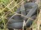
(Continuing track report from previous post)Another image from the section from Kent Creek:
I then walked the 4 km along a 4WD track to Shanty Hollow. Got there at nightfall.
The next day I followed the 4WD track up to Mt Dawson. Nice spot.
Next came Dawsons Ridge to Snowy Bluff. This was very challenging, due mostly to the thick vegetation that was present over most of the route. A machete would not have been out of place! Mostly I just crashed through and hoped my gaiters would take care of things that sting, scratch and bite (which they did - although the shock cord was torn out from under both).
Samuel L. Jackson would have some choice words to describe this stuff!
Snowy Bluff when I got there was a great place for a rest, but to be honest I was a little underwhelmed. Maybe I was just tired and cranky.

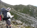
Heading back along Dawson's ridge I tried taking a route roughly along a 1300-1320 contour, well below the ridge top, and found this to be much easier going, with less vegetation to battle with. There are some great views to be had from the ridge top, but it's quite hard yakka up there.
It was a relief to get back to Mt Dawson. I was also very thirsty - I only took 2 litres of water for the day, when I really needed closer to 4 litres, particularly given the warm conditions (high 20s). A lesson learned. The little creek near Shanty Hollow was a welcome sight!
It was a long day - I had left camp at 9am and returned around 8pm - 11 hours, for a trip that is suggested to take up to 6.5 hours. I am probably not the fastest walker around, but I would still recommend to anyone heading to Snow Bluff that you should allow plenty of time for each stage.
The next day basically required me to head back down to Moroka Gorge and out. All went well until I made a nav error and headed up the wrong creek, bush bashing all the way. It was 40 mins before I realised my mistake. I couldn't stomach back-tracking through the thick vegetation, so I did a wide traverse. The new route was easier, but longer - it was 2 hours before I got back on track. (My iPhone 3GS with MudMaps app was invaluable throughout the hike and was vital in this off-route stage.)
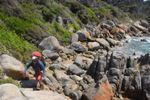
I made my way back to First Falls where a swim in the cold water there did much to put the world right again.