Forum rules
Tasmania specific bushwalking discussion. Please avoid publishing details of access to sensitive areas with no tracks.Mt Vandyke
Mon 16 May, 2011 8:51 am
Does anyone know of the three blocks on this summit, which is the highest? One is more easterly, one northerly and the other more southern. I followed the pad out to these on Saturday (in the snow) and it seemed the pad leads towards the most easterly, but it didn't look the highest. Unfortunately I couldn't check with my GPS. Batteries went flat and I didn't want to hang around to change over to new ones - way too cold and I was pretty wet by that stage after pushing through snow covered scrub coming from the Mt Claude/ Mt Vandyke saddle. I didn't attempt to climb the north south blocks - too much ice on the conglomerate and I was on my own.
Andrew
Andrew
Re: Mt Vandyke
Mon 16 May, 2011 8:55 am
Hi Andrew. I just went up the one with the cairn on it.
Re: Mt Vandyke
Mon 16 May, 2011 9:05 am
A few years since I was there, I went to the easterly top as it was the most obvious summit and the path led there (no snow to hide the path).
Re: Mt Vandyke
Mon 16 May, 2011 9:43 am
Does this answer your query?
With recreational grade GPS you may well find those heights reversed.
Those GPS are to be read with a fair amount of 'tongue in cheek' when it comes to elevations.
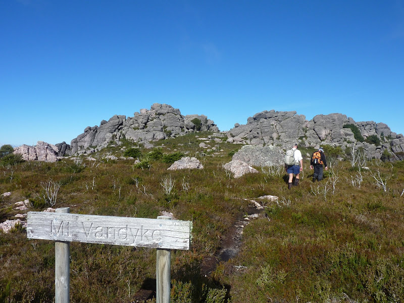
- Vandyke.jpg (77.21 KiB) Viewed 3202 times
I couldn't check with my GPS
With recreational grade GPS you may well find those heights reversed.
Those GPS are to be read with a fair amount of 'tongue in cheek' when it comes to elevations.
Re: Mt Vandyke
Mon 16 May, 2011 5:33 pm
Mark,
I didn't see any cairn on top of any? Two were covered in snow and the most easterly was full of ice. Have to go back when it is drier.
Cheers
Andrew
I didn't see any cairn on top of any? Two were covered in snow and the most easterly was full of ice. Have to go back when it is drier.
Cheers
Andrew
Re: Mt Vandyke
Mon 16 May, 2011 6:03 pm
There's a simple solution to this: when in doubt, climb them all.
Re: Mt Vandyke
Tue 17 May, 2011 5:25 pm
Hi Mark,
I walked (well actually almost walked - chalk up a victory to the weather) to Mt Roland summitt on Sunday, Mt Roland has "triangle" at summit - I'm sure there is a more technical name for this though, and according to Day Walks Tasmania (John Chapman) Mt Roland (northern most peak) is the highest at 1223m with Vandyke @ 1084 m and Mt Claude (southern peak) accordingly to the printed guide available at the walker's reg. hut has the cairns and this is slightly smaller again.
Cheers
Steve
Re: Mt Vandyke
Tue 17 May, 2011 7:00 pm
Mt Roland is definitly the highest point . In fact from the top on clear days you can look over the other 2 and see Cradle. That triangle you refer to is known as
the trig point. Hopefully your next attempt will be in better weather. Cheers Chris
the trig point. Hopefully your next attempt will be in better weather. Cheers Chris
Re: Mt Vandyke
Tue 17 May, 2011 7:19 pm
Thanks Chris,
I am looking forward to the challenge.
Cheers
Steve
I am looking forward to the challenge.
Cheers
Steve
Re: Mt Vandyke
Tue 17 May, 2011 8:57 pm
Pretty sure the eastern point marked as 1084m on maps is the high point and is also listed as the top on the PB list. The top rock with the cairn is to the left in this picture (you can't actually see the cairn in this view) and is quite close to the main traverse track. I agree it would not be much fun scrambling over the conglomerate boulders if they were icy. 
Cheers,
Rohan
Cheers,
Rohan
Re: Mt Vandyke
Tue 24 May, 2011 4:59 pm
Thanks Rowan,
All were covered in snow and ice when I was last there. The cairn I didn't see as it just looked like a snowy lump from the signpost. I climbed the middle bump to near the top before bailing out. Have to go back and do it again, I guess.
Cheers
Andrew
All were covered in snow and ice when I was last there. The cairn I didn't see as it just looked like a snowy lump from the signpost. I climbed the middle bump to near the top before bailing out. Have to go back and do it again, I guess.
Cheers
Andrew
© Bushwalk Australia and contributors 2007-2013.