Putty Beach, Box Head, Lobster Beach to Pretty Beach
Darkinjung & Guringai Country

3 h to 3 h 30 min

4.3 km
oneway

↑ 177 m
↓ -180 m

Moderate track
This walk is a great one way walk to do after spending some time at Putty Beach. The walk uses Hawke Head Drive to head along the ridge to Box Head. The headland has superb views over Broken Bay to Barrenjoey Headland and out to sea. Lobster Beach is another great beach in the area with views over to Woy Woy. A great walk from beach to beach. Let us begin by acknowledging the Darkinjung & Guringai people, Traditional Custodians of the land on which we travel today, and pay our respects to their Elders past and present. 
Show all
Putty Beach headland west. | Photo by admin
Hawke Head Drive beginning. | Photo by admin
Woy Woy from Hawke Head Drive. | Photo by admin
Track to Box Head. | Photo by admin
Box Head lookout over Broken Bay to Barrenjoey Headland. | Photo by admin
Stairs down to Lobster Beach. | Photo by admin
Lobster Beach south. | Photo by admin
Track to Road. | Photo by admin
Pretty Beach access track from road. | Photo by admin
Downloads GPX PDF

+
-
Safer Bushwalks
Tips on staying safe on track
Before you start any bushwalk ensure you;
• Tell someone you trust where you are going and what to do if you are overdue
• Have adequate equipment, supplies, skills & knowledge for the whole journey
• Consider the impact of weather forecasts, park/track closures & fire dangers
• Can respond to emergencies & call for help at any point
• Are healthy and fit enough for this journey
If not, change plans and stay safe. It is okay to delay and ask people for help.
+
-
Getting There
Transport options and directions
Start (-33.5310757,151.3608407)
Mode Car (There is free parking available.)
DirectionsFrom Wards Hill Road
  • Turn on to The Scenic Road then drive for 910 m
  • Turn left onto Beach Drive and drive for another 470 m
  • Continue onto Beach Drive and drive for another 95 m
  • Turn left and drive for another 35 m
Finish (-33.5298623,151.3414048)
Mode (end) Car Shuttle   Car   (There is free parking available.)
+
-
Track Notes
Turn by turn instructions & maps
Getting started
From the beach, this walk heads up the hill along a stony path, to the car park behind the beach.
From the car park, this walk walks onto Beach Drive and turns right to head up and away from the beach, to the intersection with The Scenic Road. A short distance up the hill, this walk soon takes the first left onto Nukara Ave. The walk continues up Nukara Ave to the second road on the left, Hawke Head Drive.....
Turn map Directions & comments
Start.
Find the car park at the start.
After another 25 m turn right, to head along Beach Drive.
After another 95 m (at the intersection of Beach Drive & Grandview Crescent) continue straight, to head along Beach Drive (a highway|tertiary).
After another 430 m (at the intersection of Beach Drive & Masson Lane) continue straight, to head along Beach Drive.
After another 30 m (at the intersection of The Scenic Road & Beach Drive) turn left, to head along Killcare Road.
After another 15 m (at the intersection of Killcare Road & Nukara Avenue) turn left, to head along Nukara Avenue (a residential road).
After another 55 m (at the intersection of Nukara Avenue & Grandview Crescent) veer right, to head along Nukara Avenue.
After another 65 m (at the intersection of Nukara Avenue & Hawke Head Drive) continue straight, to head along Hawke Head Drive.
After another 830 m (at the intersection of Old Wagstaffe Trail & Hawke Head Drive) continue straight, to head along Hawke Head Drive.
After another 285 m (at the intersection of Hawke Head Drive & Killcare Trail) continue straight, to head along Hawke Head Drive.
After another 730 m head through/around the gate.
After another 95 m turn right, to head along Hawke Head Drive.
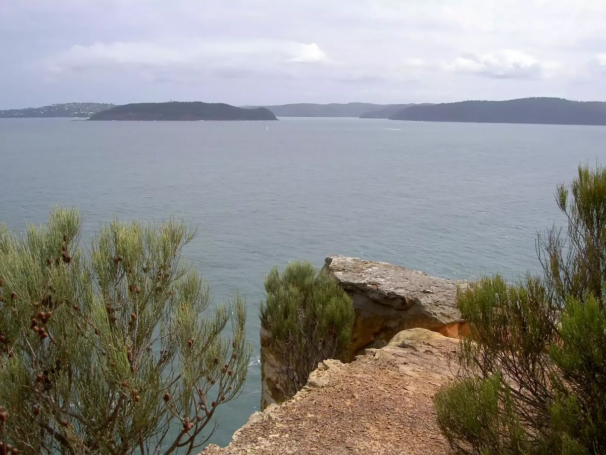
The starting point of an optional sidetrip. Side trip to Box Head for great ocean views. To start this optional side trip veer left here. On returning from this side trip continue straight when you get back to this intersection. Details below.
After another 35 m (at the intersection of Flannel Flower Walking Track & Hawke Head Drive) turn right, to head along Flannel Flower Walking Track (a walking track).
After another 1.2 km turn left.
After another 125 m head down the steps (about 55 m long)
After another 75 m come to the viewpoint (on your right).
Then pass a seat (on your right).
After another 8 m head down the steps
After another 50 m come to the end.
About 50 m past the end is "Lobster beach".
Lobster beach
Lobster beach

Lobster Beach, Bouddi National Park, is a 300m long, west-facing beach on Broken Bay. The beach, backed by a steep hill and edged by rocky shores, provides westerly views over Broken Bay to Pearl and Ocean beaches. The beach has toilet and garbage facilities just above the sand.
+
-
Lobster Beach, Bouddi National Park, is a 300m long, west-facing beach on Broken Bay. The beach, backed by a steep hill and edged by rocky shores, provides westerly views over Broken Bay to Pearl and Ocean beaches. The beach has toilet and garbage facilities just above the sand.


Side trip to Box Head for great ocean views.
Turn map Directions & comments
At the intersection of Hawke Head Drive & Flannel Flower Walking Track Start heading along Hawke Head Drive (a vehicle track).
After another 55 m (at the intersection of Hawke Head Drive & Tallow Beach Trail) continue straight.
After another 410 m come to the viewpoint (45 m on your right).
After another 265 m come to the viewpoint (10 m on your left).
After another 680 m come to "Box Head".
Box Head
Box Head

Box Head is the northern entrance to Broken Bay, and has panoramic views over the Pacific Ocean, Barrenjoey Headland, Lion Island and the rest of the bay. Box Head is an unfenced area with no other facilities. The track to the headland makes it reasonably accessible, with some great views along the way and stunning views from the point.
+
-
Box Head is the northern entrance to Broken Bay, and has panoramic views over the Pacific Ocean, Barrenjoey Headland, Lion Island and the rest of the bay. Box Head is an unfenced area with no other facilities. The track to the headland makes it reasonably accessible, with some great views along the way and stunning views from the point.

The end.
Turn around and retrace your steps back the 1.4 km to the main route.
+
-
Terrain
Know the Hills, grading & facilities

Putty Beach, Box Head, Lobster Beach to Pretty Beach


Grading
Class 3/6
Moderate track
Length 4.3 km
Time 3 h to 3 h 30 min
Quality of track Formed track, with some branches and other obstacles (3/6)
Gradient Short steep hills (3/6)
Signage Directional signs along the way (3/6)
Infrastructure Limited facilities, not all cliffs are fenced (3/6)
Experience Required No experience required (1/6)
Weather Weather generally has little impact on safety (1/6)

Some facilities on route
Seat: There is one 4.2 km from the start.


Order of key facilities on route
ItemFrom StartName & link to notes
Seat
4.2 km[seat]
+
-
Articles
Discover more details to thrive on track
+
-
Reviews & Feedback
Share your experience
+
-
Weather & Alerts
Check forecasts & closures
Show Full Weather
Alerts and Closures
Show all alerts
Show all alerts
Show all alerts
+
-
Other Journeys
Discover nearby and similar journeys
Some of the information and maps on this page was generated using data from the awesome © OpenStreetMap contributors.
Please see how you can embed some widgets, access data and other stuff to that might be helpful.