I am never sure where to put a "track update" so if this is the wrong spot, someone please point me to the right spot.
Walked into Hidden Valley and up Mount Sturgiss from Sassafras. The road into the parking area is a bit lumpy, bumpy but passable in 2WD car. Did not go out to Folly Point but met a woman who had been out there for three nights and she had done some clearing of the trail but reported that it was hard to follow in spots.
The track to Hidden Valley and Styles Creek definitely has it's moments. Up to Quilty's turnoff and down the valley along Kilpatrick Creek is pretty reasonable - lots of toppled trees, regrowth but no real drama. Where the track climbs out of Kilpatrick Creek and traverses flat ground to the Hidden Valley turn at around 700 metres the track is really overgrown with acacia. If you are lucky you will manage to stay on it, but we lost it multiple times and the bushwacking to "refind" the track is pretty slow going - dense acacia with thorny vines throughout.
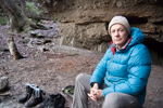
The camp at Hidden Valley turn and the few little campsites before that are quite overgrown with acacia but we did have a good camp about 100 metres from the Hidden Valley turn with water from a creek nearby. Finding the tree marking Hidden Valley took some time and we almost immediately lost the track heading towards Hidden Valley. We picked it up again near the cliff line where it contours north. No real sign of any track in Hidden Valley but walking along the west side was fine. Dark Brothers cave seems to be marked wrong on the topo map. If the big cave with obvious camping is Dark Brothers cave it is about 300 to 400 metres north of where it is marked on the topo map.
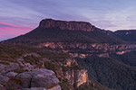
The chain scrambling up Sturgiss is a bit rusty and held in by a couple of rusty carrots, but seemed OK. Fantastic views from Sturgiss.
Hidden Valley track after fires
Forum rules
Posting large/multiple images in this forum is OK. Please start topic titles with the name of the location or track.
For topics focussed on photos rather than the trip, please consider posting in the 'Gallery' forum instead.
This forum is for posting information about trips you have done, not for requesting information about a track or area.
11 posts
• Page 1 of 1
Hidden Valley track after fires
![]() by sandym » Thu 18 Nov, 2021 6:32 am
by sandym » Thu 18 Nov, 2021 6:32 am
- sandym
- Phyllocladus aspleniifolius

- Posts: 521
- Joined: Wed 19 Sep, 2012 7:34 pm
- Region: New South Wales
- Gender: Female
Re: Hidden Valley track after fires
![]() by FionaShedden » Thu 18 Nov, 2021 8:32 am
by FionaShedden » Thu 18 Nov, 2021 8:32 am
Thanks Sandy M, I was wondering how this track looked now. We walked it just prior to the fires and it was a little indistinct in places even then, particularly in the bit from HV turn down to Styles Creek. You certainly even then had to be focussed the whole time ( although at least it was relatively easy walking even if you did take a bypass). Sounds like that is more difficult now.
Great to hear about conditions up there!
Great to hear about conditions up there!
- FionaShedden
- Atherosperma moschatum

- Posts: 54
- Joined: Wed 20 Sep, 2017 9:55 pm
- Region: New South Wales
- Gender: Female
Re: Hidden Valley track after fires
![]() by rwildman » Sat 01 Jan, 2022 1:05 pm
by rwildman » Sat 01 Jan, 2022 1:05 pm
The regrowth has even been mentioned on the NPWS website as a general warning for bushwalkers and from my few excursions in the last couple of months, they are absolutely correct. We went down to Claydon's Creek, or rather attempted to, and could only get 3.5 kms along what was left of a track before meeting the immovable object - tobacco plants with interspersed hardenbergia and lawyer vine. So its everywhere now and will probably take either more bushwalkers going back to bashing tracks through or the canopy returning and killing off the temporary growth like the acacia and the tobacco plants. Or probably a bit of both.
But I also wonder if that Sassafras entrance is being used less and less. The road in has deteriorated badly over the years and the 7kms road bash to Newhaven Gap (11kms to Camp Rock) has put walkers off for a while. Hopefully the CMW are still maintaining the Folly Point track. When I was in Tasmania down the south west cape area, I met two guys who took it upon themselves to walk in with $50 garden saws (the fold up type) and cleared whole swathes of the indistinct track down the west coast. Maybe we need to start emulating their example.
But I also wonder if that Sassafras entrance is being used less and less. The road in has deteriorated badly over the years and the 7kms road bash to Newhaven Gap (11kms to Camp Rock) has put walkers off for a while. Hopefully the CMW are still maintaining the Folly Point track. When I was in Tasmania down the south west cape area, I met two guys who took it upon themselves to walk in with $50 garden saws (the fold up type) and cleared whole swathes of the indistinct track down the west coast. Maybe we need to start emulating their example.
-
rwildman - Nothofagus gunnii

- Posts: 43
- Joined: Fri 06 Jul, 2012 10:39 pm
- Location: Summer Hill NSW
- Region: New South Wales
- Gender: Male
Re: Hidden Valley track after fires
![]() by sandym » Sat 01 Jan, 2022 6:07 pm
by sandym » Sat 01 Jan, 2022 6:07 pm
Not first hand report but when we walked out we met a lady who had walked out to Folly Point with some trail clearing tools. She reported that the Folly Point track was hard to find in places. Must be just me, but I enjoyed the "road bash" to Camp Rock.
- sandym
- Phyllocladus aspleniifolius
- Posts: 521
- Joined: Wed 19 Sep, 2012 7:34 pm
- Region: New South Wales
- Gender: Female
Re: Hidden Valley track after fires
![]() by tom_brennan » Tue 04 Jan, 2022 11:32 am
by tom_brennan » Tue 04 Jan, 2022 11:32 am
rwildman wrote:The regrowth has even been mentioned on the NPWS website as a general warning for bushwalkers and from my few excursions in the last couple of months, they are absolutely correct. We went down to Claydon's Creek, or rather attempted to, and could only get 3.5 kms along what was left of a track before meeting the immovable object - tobacco plants with interspersed hardenbergia and lawyer vine. So its everywhere now and will probably take either more bushwalkers going back to bashing tracks through or the canopy returning and killing off the temporary growth like the acacia and the tobacco plants. Or probably a bit of both.
I assume the "tobacco plants" are the native Incense Plant (Calomeria amaranthoides). This is a biennial. It popped up everywhere after the fire, and it's in flower at the moment, so I'd expect a massive die-off this winter.
https://bushwalk.com/forum/viewtopic.php?f=36&t=38808
Bushwalking NSW - http://bushwalkingnsw.com
-
tom_brennan - Athrotaxis selaginoides

- Posts: 1366
- Joined: Wed 29 Sep, 2010 9:21 am
- Location: Sydney
- Region: New South Wales
- Gender: Male
Re: Hidden Valley track after fires
![]() by Huntsman247 » Tue 04 Jan, 2022 2:42 pm
by Huntsman247 » Tue 04 Jan, 2022 2:42 pm
Just got back from a bit of a circuit. Folly point track is pretty good except the bit where you come down that steep rock slab, cross the creek and proceed up the hill which is now just overgrown. The campsite has got a bit of vegetation growing through it too.
Quite a bit of weeds from watsons down into the valley. Met a some people and read some logbook notes complaining about it being bad but it really was pretty tame compared to the area between styles camp site and the firetrail. Everything in between that area is becoming so over grown it's not enjoyable walking. Track between styles and the turn of to the borra borra site is pretty hard to follow.
Seems like very few people visit these days. Understandably, the fire damage is pretty severe in the area and styles campsite was looking so sad I decided to keep moving and exit a day earlier. Styles ck has also got an algae bloom going atm. I don't think that's really healthy either.
-
Huntsman247 - Phyllocladus aspleniifolius
- Posts: 587
- Joined: Wed 22 Mar, 2017 10:07 pm
- Region: New South Wales
- Gender: Male
Re: Hidden Valley track after fires
![]() by Walk_fat boy_walk » Tue 04 Jan, 2022 5:17 pm
by Walk_fat boy_walk » Tue 04 Jan, 2022 5:17 pm
How did you link folly pt and styles? Did you end up dropping into the valley and coming up sentinel hill or just cut across via sluice box falls?Huntsman247 wrote:Just got back from a bit of a circuit. Folly point track is pretty good except the bit where you come down that steep rock slab, cross the creek and proceed up the hill which is now just overgrown. The campsite has got a bit of vegetation growing through it too.
Quite a bit of weeds from watsons down into the valley. Met a some people and read some logbook notes complaining about it being bad but it really was pretty tame compared to the area between styles camp site and the firetrail. Everything in between that area is becoming so over grown it's not enjoyable walking. Track between styles and the turn of to the borra borra site is pretty hard to follow.
Seems like very few people visit these days. Understandably, the fire damage is pretty severe in the area and styles campsite was looking so sad I decided to keep moving and exit a day earlier. Styles ck has also got an algae bloom going atm. I don't think that's really healthy either.
Sent from my SM-G977B using Tapatalk
- Walk_fat boy_walk
- Lagarostrobos franklinii

- Posts: 2102
- Joined: Sat 21 Nov, 2009 6:59 am
- Gender: Male
Re: Hidden Valley track after fires
![]() by rwildman » Tue 04 Jan, 2022 8:25 pm
by rwildman » Tue 04 Jan, 2022 8:25 pm
Walk_fat boy_walk: How did you link folly pt and styles? Did you end up dropping into the valley and coming up sentinel hill or just cut across via sluice box falls?
You can go up the ridge above Crooked Falls then follow round under the cliff on Mt Tarn until the step up onto Mt Tarn is available and then on to Mt Houghton. Did it many, many years ago.
You can go up the ridge above Crooked Falls then follow round under the cliff on Mt Tarn until the step up onto Mt Tarn is available and then on to Mt Houghton. Did it many, many years ago.
-
rwildman - Nothofagus gunnii
- Posts: 43
- Joined: Fri 06 Jul, 2012 10:39 pm
- Location: Summer Hill NSW
- Region: New South Wales
- Gender: Male
Re: Hidden Valley track after fires
![]() by Huntsman247 » Wed 05 Jan, 2022 7:03 am
by Huntsman247 » Wed 05 Jan, 2022 7:03 am
I did neither of those options. I followed Hollands around sentinel hill and took a spur that goes straight up between Haughton and Sturgiss and puts you very close to the walking track.
Steep enough to give anything in the ettrema a run for its money and very overgrown. Worst bush wack I've done. 4hrs to cover that 900m spur. Turns out there are cliffs too at the top that you need to skirt around somewhat.
Steep enough to give anything in the ettrema a run for its money and very overgrown. Worst bush wack I've done. 4hrs to cover that 900m spur. Turns out there are cliffs too at the top that you need to skirt around somewhat.
-
Huntsman247 - Phyllocladus aspleniifolius
- Posts: 587
- Joined: Wed 22 Mar, 2017 10:07 pm
- Region: New South Wales
- Gender: Male
Re: Hidden Valley track after fires
![]() by Walk_fat boy_walk » Wed 05 Jan, 2022 8:15 am
by Walk_fat boy_walk » Wed 05 Jan, 2022 8:15 am
rwildman wrote:Walk_fat boy_walk: How did you link folly pt and styles? Did you end up dropping into the valley and coming up sentinel hill or just cut across via sluice box falls?
You can go up the ridge above Crooked Falls then follow round under the cliff on Mt Tarn until the step up onto Mt Tarn is available and then on to Mt Houghton. Did it many, many years ago.
Thanks, yeh I'm yet to do the bit from the falls up onto Mt Tarn... I believe there's a decent cave there too? Was particularly interested to see if he'd done the ridge over Sentinel Hill (I think was proposed in another thread) as I've often looked at that hill from a distance and thought while not much of a hill, it's right in the middle of everything and I'd imagine there'd be some pretty good 360 degree views?
- Walk_fat boy_walk
- Lagarostrobos franklinii
- Posts: 2102
- Joined: Sat 21 Nov, 2009 6:59 am
- Gender: Male
Re: Hidden Valley track after fires
![]() by Huntsman247 » Thu 06 Jan, 2022 12:17 pm
by Huntsman247 » Thu 06 Jan, 2022 12:17 pm
360 degree views of lantana. LolWalk_fat boy_walk wrote:rwildman wrote:Walk_fat boy_walk: How did you link folly pt and styles? Did you end up dropping into the valley and coming up sentinel hill or just cut across via sluice box falls?
You can go up the ridge above Crooked Falls then follow round under the cliff on Mt Tarn until the step up onto Mt Tarn is available and then on to Mt Houghton. Did it many, many years ago.
Thanks, yeh I'm yet to do the bit from the falls up onto Mt Tarn... I believe there's a decent cave there too? Was particularly interested to see if he'd done the ridge over Sentinel Hill (I think was proposed in another thread) as I've often looked at that hill from a distance and thought while not much of a hill, it's right in the middle of everything and I'd imagine there'd be some pretty good 360 degree views?
Exiting via Mount Tarn was really scrubby before the fires between the top of crooked falls and tarn. Is a nice CC though.
-
Huntsman247 - Phyllocladus aspleniifolius
- Posts: 587
- Joined: Wed 22 Mar, 2017 10:07 pm
- Region: New South Wales
- Gender: Male
11 posts
• Page 1 of 1
Return to NSW & ACT Trip Reports & Track Notes
Who is online
Users browsing this forum: No registered users and 10 guests