Hi all,
I am intresting in walking the Norfolk Ranges does any one have any information or tips on this matter
Cheers
Matt
Norfolk Range
Forum rules
Tasmania specific bushwalking discussion. Please avoid publishing details of access to sensitive areas with no tracks.
Tasmania specific bushwalking discussion. Please avoid publishing details of access to sensitive areas with no tracks.
12 posts
• Page 1 of 1
Norfolk Range
![]() by mattanitah » Sun 04 Jan, 2009 9:28 am
by mattanitah » Sun 04 Jan, 2009 9:28 am
-
mattanitah - Nothofagus gunnii

- Posts: 17
- Joined: Tue 02 Dec, 2008 3:02 am
- Location: Marrawah
- Region: Tasmania
Re: Norfolk Range
![]() by MrCAMEL » Sun 04 Jan, 2009 5:19 pm
by MrCAMEL » Sun 04 Jan, 2009 5:19 pm
I have also been trying to find out things about the range as well. But, there really isn't (probably is somewhere I cannot find) much written about it. I have seen on the Launceston Walking Club website they have had a few walks in the range this year. So I assume they could answer questions about the places they visited.
I don't think there would be much water out there. As you it would obviously be pretty windy. The southern parts are (were a couple of months ago) pretty bare from the fire last year. I don't really konw anything, someone will. I will ask some old people around town and see what they say
I don't think there would be much water out there. As you it would obviously be pretty windy. The southern parts are (were a couple of months ago) pretty bare from the fire last year. I don't really konw anything, someone will. I will ask some old people around town and see what they say
Vrilen Snyson Racing: Finding us all a Vrilen
Asparagus: Experience the versatility
Asparagus: Experience the versatility
-

MrCAMEL - Athrotaxis cupressoides

- Posts: 104
- Joined: Fri 18 Jul, 2008 11:10 pm
- Location: Mongol Land
- Region: Other Country
Re: Norfolk Range
![]() by mattanitah » Mon 05 Jan, 2009 11:40 am
by mattanitah » Mon 05 Jan, 2009 11:40 am
I am going to speak to a guy in the next couple of days who crossed the norfolk range and finished up at sandy cape, I will let you know any info I find out
cheers
Matt
cheers
Matt
-
mattanitah - Nothofagus gunnii
- Posts: 17
- Joined: Tue 02 Dec, 2008 3:02 am
- Location: Marrawah
- Region: Tasmania
Re: Norfolk Range
![]() by Son of a Beach » Mon 05 Jan, 2009 12:01 pm
by Son of a Beach » Mon 05 Jan, 2009 12:01 pm
mattanitah wrote:...finished up at sandy cape
That's a long way from anywhere to be finishing up at.
- Son of a Beach
- Lagarostrobos franklinii

- Posts: 6930
- Joined: Thu 01 Mar, 2007 7:55 am
- ASSOCIATED ORGANISATIONS: Bit Map (NIXANZ)
- Region: Tasmania
- Gender: Male
Re: Norfolk Range
![]() by mattanitah » Mon 05 Jan, 2009 12:29 pm
by mattanitah » Mon 05 Jan, 2009 12:29 pm
Yeah they had some guys on 4 wheelers organised to pick them up.....
I was not intrested in this walk I would just like to reach the different peaks along the range

I was not intrested in this walk I would just like to reach the different peaks along the range
-
mattanitah - Nothofagus gunnii
- Posts: 17
- Joined: Tue 02 Dec, 2008 3:02 am
- Location: Marrawah
- Region: Tasmania
Re: Norfolk Range
![]() by tastrekker » Mon 05 Jan, 2009 8:50 pm
by tastrekker » Mon 05 Jan, 2009 8:50 pm
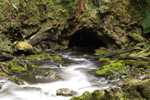
Unfortunately, I have not walked in this area much at all. Therefore, I will give some answers that are based upon the information available online via the LIST (http://www.thelist.tas.gov.au). The benefit of the LIST is that you can switch between the 1:250,000, 1:100,000 and 1:25,000 topographic maps as background imagery and add layers to provide information about roads and walking tracks, etc. E.g. The 1:25,000 maps of the Norfolk Range are too old to show the "Road to Nowhere" (aka Heemskirk Road, aka Tarkine Road, aka Western Explorer, etc). The road layer on the LIST is kept very well up to date.
Looking at the map, there appears to be a track up Mt Hazelton, the northern most peak in the range. Bob Brown wrote a book called "Tarkine Trails" before 'the road' was built. In it, he describes walks to Mt Donaldson, The Longback, Mt Sunday and Mt Balfour which are in the vicinity of the Norfolk Range. These walk descriptions combined with the new road could give some tips about walking in the area.
I was quite interested in the Norfolk Range until the road was built. Now, sadly, the road would appear as a windy white ribbon of quartzite as it snakes its way along the ridge tops just east of the range for most of its length. As it was built very cheaply and in a huge hurry, the quickest and easiest route was along the subtle ridges through the boggy plains. This was great for drainage but not so good in terms of hiding the visual impact of the road.
To finish, I'll quote one bit of Bob's book which is actually a quote from Jorgen Jorgensen describing his 'walk' through the Donaldson River ravine: "Fallen trees in every direction interrupted our march, and it is a question whether ever human beings civilised or savage had ever visited this savage looking country. Be this as it may, all about us appeared well calculated to arrest the progress of the traveller, sternly forbidding man to traverse those places which nature has selected for its own silent and awful repose."
P.S. Mattanitah, I think your last post here has blown your cover. You are just a mad peak bagger who is attempting to scavenge a few measly points out of the Norfolk Range to count towards the Tasmanian Tramp's "Peak Baggers Guide to Tasmania."
P.P.S Perhaps it takes one to know one.
-

tastrekker - Athrotaxis cupressoides
- Posts: 499
- Joined: Thu 20 Sep, 2007 9:04 pm
- Location: Lenah Valley
- Region: Tasmania
- Gender: Male
Re: Norfolk Range
![]() by MrCAMEL » Mon 05 Jan, 2009 9:22 pm
by MrCAMEL » Mon 05 Jan, 2009 9:22 pm
Just a handful of weeks ago I tried to go up Mr Hazelton. I wrote a little bit in here about it
viewtopic.php?f=24&t=825
I know from my short time up high(ish), I could not see any road. But it seems the road is never far away from the mountains.
Seeing as I bought my first tent and Santa got me a lot of new gear, I will, when possible have an extended look in the area, just for fun and to see what goes on, in the near future. And it will be good
Vrilen Snyson Racing: Finding us all a Vrilen
Asparagus: Experience the versatility
Asparagus: Experience the versatility
-
MrCAMEL - Athrotaxis cupressoides
- Posts: 104
- Joined: Fri 18 Jul, 2008 11:10 pm
- Location: Mongol Land
- Region: Other Country
Re: Norfolk Range
![]() by Pedro » Tue 06 Jan, 2009 8:11 am
by Pedro » Tue 06 Jan, 2009 8:11 am
Did a walk from Pieman Heads to the Arthur River along the beach back in the very late 60's. Somewhere south of Sandy Head (maybe Lagoon River), we headed inland and climbed Mt Norfolk. It wasn't far from the coast, but though it looked like a flat, open walk, it turned out to be less than simple. Lots of scrub, with nasty steep sided little gullies cutting across the plain. I think it took a couple of days in and back to the coast. We found a track up the mountain and drums of fuel and other junk on the top - it was obviously being used by helicopters as an exploration base.
- Andrew Boon and Pat Flanagan near the top of Mt Norfolk
- Junk all over the summit area
- Camping on the way back to the coast
-

Pedro - Atherosperma moschatum

- Posts: 84
- Joined: Thu 01 May, 2008 9:02 pm
- Region: Tasmania
Re: Norfolk Range
![]() by paulpeakbagger » Thu 08 Jan, 2009 1:25 pm
by paulpeakbagger » Thu 08 Jan, 2009 1:25 pm
I have climbed all the major peaks of the Norfolk Range - Balfour, Frankland, Hazelton, Lily, West Bluff, Mabel, Norfolk, Helen, Edith, Hadmar, Vero and Sunday.
There is a track to the summit of Balfour and also one to the summit of Hazelton though the last bit is indistinct following the fire. Edith and Hadmar are relatively easy walks across the burnt plains.
All the rest are scrubby in places and Mt Sunday requires an overnight trip.
I have not visited the area since the most recent fires.
Contact me for details.
Paul
- paulpeakbagger
- Nothofagus cunninghamii

- Posts: 8
- Joined: Thu 09 Oct, 2008 12:58 pm
- Region: Tasmania
Re: Norfolk Range
![]() by Moilatene » Sat 06 Jun, 2015 11:50 am
by Moilatene » Sat 06 Jun, 2015 11:50 am
Paul, do you have any advice re approach to Mt Sunday from all those years ago? Apparently an old 4WD track approaches from the Pieman. Has anyone approached it from the Western Explorer (east approach), crossing the Toner then heading over the pass between Vero and Hadmar?
Cheers.
Cheers.
-
Moilatene - Nothofagus cunninghamii
- Posts: 2
- Joined: Thu 04 Jun, 2015 12:51 pm
- Region: Tasmania
- Gender: Female
Re: Norfolk Range
![]() by Osik » Mon 08 Jun, 2015 8:00 pm
by Osik » Mon 08 Jun, 2015 8:00 pm
Evening all, if you haven't already, I'd highly recommend picking up a copy of Bob Brown's ''tarkine trails' it's about 20 years old so things may have changed a little but a priceless resource nonetheless. Library has copies.
Edit, sorry, just read tastrekkers post : See above!
Edit, sorry, just read tastrekkers post : See above!
-

Osik - Athrotaxis cupressoides
- Posts: 372
- Joined: Sun 23 May, 2010 3:26 pm
- Location: NT Top End
- Region: Northern Territory
- Gender: Male
Re: Norfolk Range
![]() by Moilatene » Mon 08 Jun, 2015 8:58 pm
by Moilatene » Mon 08 Jun, 2015 8:58 pm
Osik
A revised edition is being worked on as we speak. Will be a fantastic resource promoting the wonderful bushwalking potential of this region.
A revised edition is being worked on as we speak. Will be a fantastic resource promoting the wonderful bushwalking potential of this region.
-
Moilatene - Nothofagus cunninghamii
- Posts: 2
- Joined: Thu 04 Jun, 2015 12:51 pm
- Region: Tasmania
- Gender: Female
12 posts
• Page 1 of 1
Who is online
Users browsing this forum: seakar and 99 guests